The Dictionary of Polish Place Names (Nazwy Miejscowe Polski) explains the origin of place names in Poland and details how the place name changed over time.
Volume IX of Nazwy Miejscowe Polski lists one place called Pomaski Wielkie. This entry is for a village which belongs to the Szwelice parish.
Nazwy Miejscowe Polski indicates that Pomaski Wielkie was in the Szelków Gmina, Ostrołęka Voivodeship in the years 1975-1998 and was located 5.5 kilometers southwest of Maków Mazowiecki. Mentions of the village include: “The Duke gave Strachenycze to the said Pomaskys, heirs of Wełen, 10 manors around his area; heir of Pomasky in (1414-25) 1456, Pomasky in 1427, Pomasky in 1436 and 1539, Pomasky in 1483, Pomassky in 1495, Pomaski in 1514, Pomaski in 1582, Pomaski w. in 1783, Pomaski wielkie in 1827, Pomaski Wielkie in 1887, and Pomaski Wielkie, -mask -kich, pomaskowski in 1971.
The name of the village of Pomaski comes from the personal name Pomaska (: pomazać ‘to anoint’), in the first person plural. From the 18th century, the name appears with a differentiating element: the adjective wielki [great]. Pomaski is the name of a so-called noble district in the area of which villages with the following names were established: Pomaski-Jałbrzyki, Pomaski-Kownaty, Pomaski-Michały, Pomaski-Sikuty, Pomaski-Zelki (today Zelki Dąbrowne) and Pomaski Wielkie.
Source: Rymut, Kazimierz and Barbara Czopek-Kopciuch, eds., Nazwy Miejscowe Polski (Place Names of Poland) – Krakow 2013, Volume IX, pages 136-137.
Click the link for a PDF copy of the Nazwy Miejscowe Polski entry for Pomaski Wielkie. Translated from the Polish, the entry reads:
Pomaski Wielkie, a village in the Ostrołęka voivodeship, Szelków gmina, 5.5 kilometers southwest of Maków Mazowiecki: “The Duke gave Strachenycze to the said Pomaskys, heirs of Wełen, 10 manors around his area; heir of Pomasky (1414-25) 1456 SHGMz (MK 3, 86 and 109); Pomasky 1427 MkM I nr 535; Pomasky 1436, 1539 Matr IV/1, nr 6365; Pomasky 1483 SHGMz (MK 6, 162); Pomassky 1495 SHGMz (Ep. 15, 49v-50); Pomaski 1514 SHGMz (PT 1, 88); Pomaski 1582 ŹDz XVI 392; Pomaski w. 1783 MpPerMz; Pomaski wielkie 1827 Tabella II 107; Pomaski Wielkie 1887 SG VIII 737; Pomaski Wielkie, -mask -kich, pomaskowski 1971 UN 129, 49. – From the personal name Pomaska (: pomazać ‘to anoint’), in the first person plural, compare the first record. From the 18th century, the name appears with a differentiating element from the adjective wielki [great]. Pomaski is the name of a so-called noble district in the area of which villages with the following names were established: Pomaski-Jałbrzyki, Pomaski-Kownaty, Pomaski-Michały, Pomaski-Sikuty, Pomaski-Zelki (today Zelki Dąbrowne) and Pomaski Wielkie. Lithuanian: ZMaz 303. Urszula Bijak
The Dictionary of Polish Place Names (Nazwy Miejscowe Polski) explains the origin of place names in Poland and details how the place name changed over time.
Volume IX of Nazwy Miejscowe Polski lists one place called Pomaski-Sikuty. This entry is for a village which is now known as Pomaski Małe and which belongs to the Szwelice parish.
Nazwy Miejscowe Polski indicates that Pomaski-Sikuty was in the Szelków Gmina, Ostrołęka Voivodeship in the years 1975-1998 and was located 5.5 kilometers southwest of Maków Mazowiecki. Mentions of the village include Pomaski Michałi in 1582, [Pomaski-Michały (Michałki), Pomaski-Sikuty], Pomaski Sikuty in 1783, Pomaski sikuty in 1827, Pomaski Sikuty in 1839, Pomaski Sikuty in 1887, Pomaski-Sikuty, -mask -kut, sikucki in 1971, Pomaski-Sikuty, -mask-Sikut in 1982, and Pomaski Male, -sek -łych, pomaskowski in 1996.
In the 16th century, the village was called Pomaski-Michały. See below for the first part; the second part is from the personal name Michał in the plural. From the 18th century, the second part changed to Sikuty, from the settlement name Sikuta in the plural.
Source: Rymut, Kazimierz and Barbara Czopek-Kopciuch, eds., Nazwy Miejscowe Polski (Place Names of Poland) – Krakow 2013, Volume IX, page 136.
Click the link for a PDF copy of the Nazwy Miejscowe Polski entry for Pomaski-Sikuty. Translated from the Polish, the entry reads:
Pomaski-Sikuty, today Pomaski Małe, a village in the Ostrołęka voivodeship, Szelków gmina, 5.5 kilometers southwest of Maków Mazowiecki: Pomaski Michałi 1582 ŹDz XVI 392; [Pomaski-Michały (Michałki), Pomaski-Sikuty] XVI AtMz 206; Pomaski Sikuty 1783 MpPerMz; Pomaski sikuty 1827 Tabella II 107; Pomaski Sikuty 1839 MpKwat IV 2; Pomaski Sikuty 1887 SG VIII 737; Pomaski-Sikuty, -mask -kut, sikucki 1971 UN 129, 49; Pomaski-Sikuty, -mask-Sikut 1982 WUN III 16; Pomaski Małe, -sek -łych, pomaskowski 1996 MPol no. 79, item 713. – In the 16th century, Pomaski-Michały; see below for the first part, the second part is from the personal name Michał, in the plural. From the 18th century, the second part changed to Sikuty, from the settlement name Sikuta SSNO V 75, in the plural. Lithuanian: ZMaz 303. Urszula Bijak
The Dictionary of Polish Place Names (Nazwy Miejscowe Polski) explains the origin of place names in Poland and details how the place name changed over time.
Volume IX of Nazwy Miejscowe Polski lists one place called Pomaski-Kownaty. This entry is for a hamlet, formerly a village, which belonged to the Szwelice parish. Listings for Pomaski-Kownaty were found until 1967.
Nazwy Miejscowe Polski indicates that Pomaski-Kownaty was in the Szelków Gmina, Ostrołęka Voivodeship in the years 1975-1998 and was located 6 kilometers southwest of Maków Mazowiecki. Mentions of the village include Cownaczsky’s mórg in 1448, Slasske borders, Cownaczske and Swyelyczske in 1467, Kownathy in 1487, Cownathy in 1511, Pomaski Kownathi in 1582, Pomaski in 1783-84, Pomaski Kownaty in 1827, Pomaski Kownaty in 1839, Pomaski Kownaty in 1887, and Pomaski-Kownaty in 1967.
Pomaski-Kownaty was formerly named Kownaty from the name of a settlement called Kownata, in the 1st person plural. From the 16th century, the village was called Pomaski-Kownaty. See Pomaski Wielkie about the first part of the name.
Source: Rymut, Kazimierz and Barbara Czopek-Kopciuch, eds., Nazwy Miejscowe Polski (Place Names of Poland) – Krakow 2013, Volume IX, page 136.
Click the link for a PDF copy of the Nazwy Miejscowe Polski entry for Pomaski-Kownaty. Translated from the Polish, the entry reads:
Pomaski-Kownaty, the hamlet was listed until 1967, formerly a village, Ostrołęka voivodeship, Szwelice gmina [in the years 1975-1998], 6 kilometes southwest of Maków Mazowiecki: Cownaczsky’s mórg [a mórg is an area of land; Gerald Ortell’s book on Polish Parish Records states that in the Russian partition 1 mórg = 1.388 acres] 1448 SHGMz(MK 4, 84); Slasske borders, Cownaczske and Swyelyczske 1467 SHGMz(MK 5, 86); Kownathy 1487 SHGMz(Ep. Il, 274v); Cownathy 1511 SHGMz(Ep. 149, 161v); Pomaski Kownathi 1582 ŹDz XVI 392; Pomaski 1783-84 RejKor 517; Pomaski Kownaty 1827 Tabella II 107; Pomaski Kownaty 1839 MpKwat IV 2; Pomaski Kownaty 1887 SG VIII 737; Pomaski-Kownaty 1967 SM 899. – Formerly named Kownaty, from the name of a settlement Kownata SSNO III 115, in the 1st person plural. From the 16th century, Pomaski-Kownaty; see Pomaski Wielkie about the first part. Lithuanian.: ZMaz 303. Urszula Bijak
The Dictionary of Polish Place Names (Nazwy Miejscowe Polski) explains the origin of place names in Poland and details how the place name changed over time.
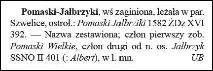
Volume IX of Nazwy Miejscowe Polski lists one place called Pomaski-Jałbrzyki. This entry is for a vanished village which belonged to the Szwelice parish. Pomaski-Jałbrzyki would have been in the Ostrołęka Voivodeship in the years 1975-1998. The only mention of the village was as Pomaski Jalbrziki in 1582.
The name was a compound. For the first part see Pomaski Wielkie; the second part was from the name of a settlement Jałbrzyk in the 1st half of the 16th century.
Source: Rymut, Kazimierz and Barbara Czopek-Kopciuch, eds., Nazwy Miejscowe Polski (Place Names of Poland) – Krakow 2013, Volume IX, page 136.
Click the link for a PDF copy of the Nazwy Miejscowe Polski entry for Pomaski-Jałbrzyki. Translated rom the Polish, the entry reads:
Pomaski-Jałbrzyki, a vanished village, was located in the parish of Szwelice, Ostrołęka voivodeship: Pomaski Jalbrziki 1582 ŹDz XVI 392. – The name is a compound; the first part see Pomaski Wielkie, the second part from the name of a settlement Jałbrzyk SSNO II 401 (: Albert), in the 1st half of the 16th century. Urszula Bijak
The Dictionary of Polish Place Names (Nazwy Miejscowe Polski) explains the origin of place names in Poland and details how the place name changed over time.
Volume IX of Nazwy Miejscowe Polski lists one places called Pomaski-Głódki. This entry is for a village currently in the Masovian Voivodeship, which belongs to the Szwelice parish.
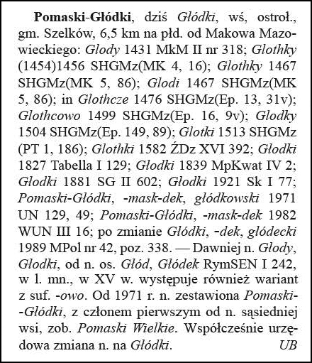
Nazwy Miejscowe Polski indicates that Pomaski-Głódki was in the Szelków Gmina, Ostrołęka Voivodeship in the years 1975-1998. Mentions of the village include Głody in 1431, Glothky in (1454) 1456, Glothky in 1467, Glodi in 1467, in Glothcze in 1476, Glothcowo in 1499, Glodky in 1504, Glotki in 1513, Glothki in 1582, Głodki in 1827, Głodki in 1839, Głodki in 1881, Głodki in 1921, Pomaski-Głódki, -mask-dek, glódkowski in 1971, Pomaski-Glódki, -mask-dek in 1982, and after the change Glódki, -dek, glódecki in 1989.
Formerly named Głody, Głodki, from the name of a settlement Głód, Glódek. In the plural form, in the 15th century a variant with the suffix -owo also appeared. In 1971, the name was combined as Pomaski-Glódki, with the first part from the name of the neighboring village Pomaski Wielkie. Currently, the official name is Glódki.
Source: Rymut, Kazimierz and Barbara Czopek-Kopciuch, eds., Nazwy Miejscowe Polski (Place Names of Poland) – Krakow 2013, Volume IX, page 136.
Click the link for a PDF copy of the Nazwy Miejscowe Polski entry for Pomaski-Głódki. Translated rom the Polish, the entry reads:
Pomaski-Głódki, today Glódki, a village in the Ostrołęka voivodeship, Szelków gmina, 6.5 km south of Maków Mazowiecki: Głody 1431 MkM II no. 318; Glothky (1454) 1456 SHGMz (MK 4, 16); Glothky 1467 SHGMz (MK 5, 86); Glodi 1467 SHGMz (MK 5, 86); in Glothcze 1476 SHGMz (Ep. 13, 31v); Glothcowo 1499 SHGMz (Ep. 16, 9v); Glodky 1504 SHGMz (Ep. 149, 89); Glotki 1513 SHGMz (PT 1, 186); Glothki 1582 ŹDzXVI 392; Głodki 1827 Tabella I 129; Głodki 1839 MpKwat IV 2; Głodki 1881 SG II 602; Głodki 1921 Sk I 77; Pomaski-Głódki, -mask-dek, glódkowski 1971 UN 129, 49; Pomaski-Glódki, -mask-dek 1982 WUN III 16; after the change Glódki, -dek, glódecki 1989 MPol no. 42, item 338. – Formerly named Głody, Głodki, from the name of a settlement Głód, Glódek RymSEN I 242, in the plural form, in the 15th century a variant with the suffix -owo also appears. Since 1971, the name has been combined as Pomaski-Glódki, with the first part from the name of the neighboring village, see Pomaski Wielkie. Currently, the official name change is to Glódki. Urszula Bijak
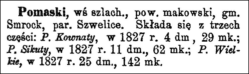
The Słownik Geograficzny Królestwa Polskiego i Innych Krajów Słowiańskich (Geographical Dictionary of the Kingdom of Poland and other Slavonic Countries) includes one entry for the Polish village of Pomaski currently in Maków Powiat, belonging to the parish of Szwelice.
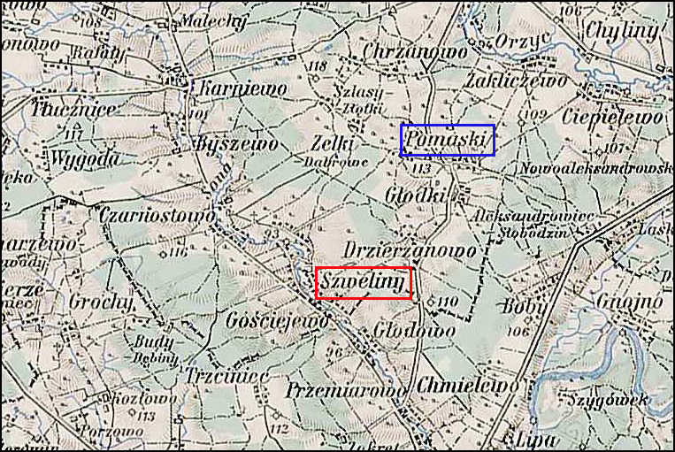
Pomaski and Surrounding Area – 1910
Third Military Mapping Survey of Austria-Hungary (ELTE Faculty of Informatics, Institute of Cartography and Geoinformatics); digital images, Lazarus ELTE (http://lazarus.elte.hu/hun/digkonyv/topo/200e/39-53.jpg: accessed 20 December 2025)
Source: Chlebowski, Bronisław and Władysław Walewski, eds., Słownik Geograficzny Królestwa Polskiego i Innych Krajów Słowiańskich (Geographical Dictionary of the Kingdom of Poland and other Slavonic Countries) – Warsaw 1887, Volume VIII, page 737.
Click on the link for a PDF copy of the the Słownik Geograficzny entry for Pomaski. Translated from the Polish, the entry reads:
Pomaski, a noble village in Maków powiat, Smrock gmina, Szwelice parish. It consists of three parts: Pomaski Kownaty, with 4 houses and 29 inhabitants in 1827; Pomaski Sikuty, with 11 houses and 62 inhabitants in 1827; and Pomaski Wielkie, with 25 houses and 142 inhabitants in 1827.
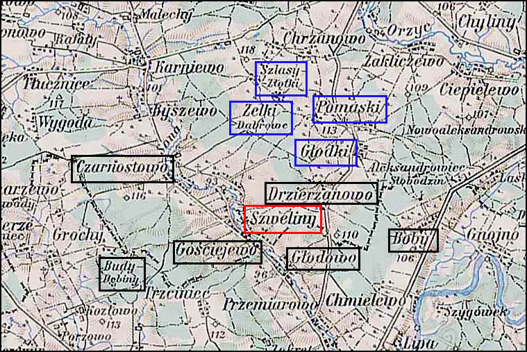
The Słownik Geograficzny Królestwa Polskiego i Innych Krajów Słowiańskich (Geographical Dictionary of the Kingdom of Poland and other Slavonic Countries) includes one entry for the Polish village of Szwelice currently in Maków Powiat. Szwelice was the local parish and, at the time the Słownik Geograficzny was written, was an ecclesiastical village owned by the local bishop.
In the map below, the village of Szwelice is indicated by a red box. Villages belonging to the local bishop and part of the parish of Szwelice are indicated by black boxes. Villages owned by the lesser nobility and part of the parish of Szwelice are indicated by blue boxes.
Szwelice and Surrounding Area – 1910
Third Military Mapping Survey of Austria-Hungary (ELTE Faculty of Informatics, Institute of Cartography and Geoinformatics); digital images, Lazarus ELTE (http://lazarus.elte.hu/hun/digkonyv/topo/200e/39-53.jpg: accessed 20 December 2025)
Source: Chlebowski, Bronisław, ed., Słownik Geograficzny Królestwa Polskiego i Innych Krajów Słowiańskich (Geographical Dictionary of the Kingdom of Poland and other Slavonic Countries) – Warsaw 1892, Volume XII, pages 89-90.
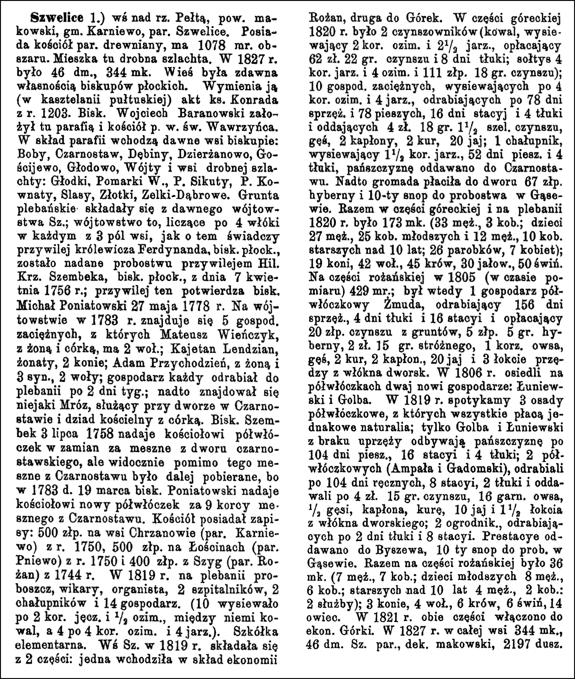
Click on the link for a PDF copy of the the Słownik Geograficzny entries for Szwelice. Translated from the Polish, the entry for Szwelice reads:
Szwelice 1.) a village on the Pełta River, Maków powiat, Karniewo gmina, Szwelice parish. It has a wooden parish church and covers an area of 1078 mórgs [Gerald Ortell’s book on Polish Parish Records states that in the Russian partition 1 mórg = 1.388 acres]. It is inhabited by minor nobility. In 1827, there were 46 houses and 344 inhabitants. The village was historically owned by the bishops of Płock. It is mentioned (in the Pułtusk castellany) in a document of Duke Konrad from 1203. Bishop Wojciech Baranowski founded the parish and the church of Św. Wawrzyniec [St. Lawrence] here. The parish includes villages formerly governed by the local bishop: Boby, Czarnostaw, Dębiny, Dzierżanowo, Dościjewo, Głodowo, Wójty, and villages of minor nobility: Głodki, Pomarki Wielkie., Pomaski Sikuty, Pomaski Kownaty, Slasy, Złotki, and Zelki-Dąbrowe. The parish lands consisted of the former Szwelice jurisdiction; this jurisdiction, comprising 4 włóki [1 włóka = 30 mórgs] in each of the 3 fields of the village, as evidenced by the privilege of Prince Ferdinand, Bishop of Płock, was granted to the parish by a privilege of Hilary Krzysztof Szembek, Bishop of Płock, dated April 7, 1756; this privilege was confirmed by Bishop Michał Poniatowski on May 27, 1778. In 1783, the jurisdiction had 5 tenant farmers, of whom Mateusz Wieńczyk with his wife and daughter, had 2 oxen; Kajetan Lendzian, married, 2 horses; Adam Przychodzień with his wife and 3 sons, 2 oxen; each farmer worked 2 days a week for the rectory; Furthermore, there was a certain Mróz, a servant at the manor in Czarostaw, and a church sexton with his daughter. Bishop Szembek, on July 3, 1758, granted the church ½ włóka of land in exchange for tithes from the Czarostaw manor, but apparently, despite this, tithes from Czarostaw continued to be collected, because on March 19, 1783, Bishop Poniatowski granted the church another ½ włóka of land for 9 bushels of tithes from Czarnostaw [now called Czarnostów]. The church possessed endowments: 500 Polish zlotys in the village of Chrzanowo (Karniewo parish) from the year 1750, 500 Polish zlotys in Łościn (Pniewo parish) from 1750, and 400 Polish zlotys from Szygi (Rożan parish) from 1744. In 1819, the rectory housed the parish priest, vicar, organist, 2 hospital attendants, 2 cottagers, and 14 farmers. (10 sowed 2 bushels of barley and ½ bushel of winter grain each, including the blacksmith, and 4 sowed 4 bushels of winter grain and 4 bushels of spring grain each). There was an elementary school. In 1819, he village of Szwelice consisted of 2 parts: one was part of the Rożan estate, the other belonged to Górki. In the Górki part in 1820 there were 2 tenants (a blacksmith, sowing 2 bushels of winter grain and 2 1/3 bushels of spring grain, paying 62 złoty and 22 groszy in rent and 8 days of labor; the village headman sowing 4 bushels of spring grain and 4 bushels of winter grain and 111 złoty and 18 groszy in rent); 10 hired farmers, sowing 4 bushels of winter grain each, and 4 cottagers, working 78 days with a team of horses and 78 days on foot, 16 days of station work and 4 days of threshing, and paying 4 zloty 18 groszy 1½ shillings in rent, a goose, 2 capons, 2 chickens, 20 eggs; 1 cottager, sowing 1½ korzec [bushel] of grain, 52 days on foot and 4 days of threshing, the serfs were sent to Czarnostaw [Czarnostaw is now Czarnostowo] to perform forced labor. In addition, the community paid 67 Polish złoty in winter tax to the manor and 1/10 sheaf to the rectory in Gąsewo. In total, in the Górecki part and at the rectory in 1820 there were 173 inhabitants (33 men, 3 women; 27 boys, 25 girls younger than 10 years old; and 12 boys, 10 girls older than 10 years old; 26 farmhands, 7 women); 19 horses, 42 oxen, 45 cows, 30 heifers, 50 pigs. In the Rożański part in 1805 (at the time of the survey) there were 429 mórgs; at that time there was one ½ włóka farmer, Żmuda, working 156 days with a team of horses, 4 days of threshing and 16 days of station work and paying 20 Polish złoty in rent for the land, 5 Polish złoty 5 groszy in winter tax, 2 złoty 15 groszy in watchman’s fee, 1 korzec of oats, a goose, 2 chickens, 2 capons, 20 eggs and 3 cubits of yarn from the manor’s fiber.In 1806, two new farmers settled on the ½ włóka plots: Łuniewski and Golba. In 1819, we find three ½ włóka settlements, all of which pay the same in kind; only Golba and Łuniewski, due to a lack of harnesses, performed serf labor for 104 days on foot, covering 16 stages and 4 threshing sessions; two ½ włóka tenants (Ampała and Gadomski) worked 104 days of manual labor, 8 stages, 2 threshing sessions, and paid 4 złoty and 15 groszy in rent, 16 measures of oats, ½ goose, a capon, a hen, 10 eggs, and 1 ½ cubits of flax from the manor; two gardeners worked 2 days of threshing and 8 stages. Services were rendered to Byszewo, and 10 sheaves were given to the parish priest in Gąsewo. In total, the Rożan part of the village had 36 inhabitants (7 men, 7 women; 8 younger children, 6 older children over 10 years old; 2 servants); 3 horses, 4 oxen, 6 cows, 6 pigs, 14 sheep. In 1821, both parts were incorporated into the Górki estate. In 1827, the entire village had 344 inhabitants and 46 houses. Parish of Szwelice, Maków deanery, 2197 souls.
The Dictionary of Polish Place Names (Nazwy Miejscowe Polski) explains the origin of place names in Poland and details how the place name changed over time.
Volume II of Nazwy Miejscowe Polski lists four places called Daniłowo. This entry is for a village currently in the Masovian Voivodeship, which belongs to the Szelków parish.
Nazwy Miejscowe Polski indicates that Daniłowo was in the Szelków Gmina, Ostrołęka Voivodeship in the years 1975-1998. Mentions of the village include Daniłowo in 1827, Daniłowo in 1839, Daniłowo, village in 1880, Daniłowo in 1921, Daniłowo, village in 1967, and Daniłowo, -wa in 1980.
Daniłowo is currently a part of the village of Smrock-Kolonia.
Source: Rymut, Kazimierz, ed., Nazwy Miejscowe Polski (Place Names of Poland) – Krakow 1997, Volume II, page 261.
Click the link for a PDF copy of the Nazwy Miejscowe Polski entry for Danilowo. Translated rom the Polish, the entry reads:
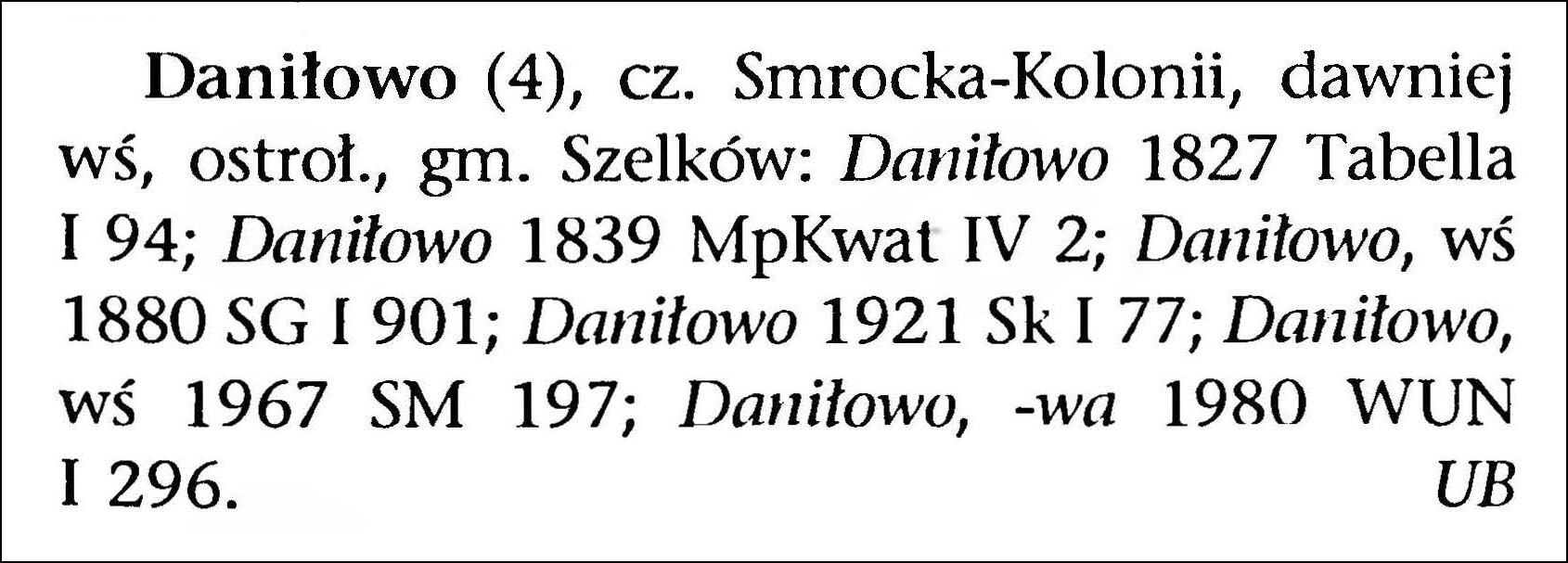
Daniłowo (4), part of Smrock-Kolonia, formerly a village, Ostrołęka voivodeship, Szelków gmina: Daniłowo 1827 Tabella I 94; Daniłowo 1839 MpKwat IV 2; Daniłowo, village 1880 SG I 901; Daniłowo 1921 Sk I 77; Daniłowo, village 1967 SM 197; Daniłowo, -wa 1980 WUN I 296. Urszula Bijak
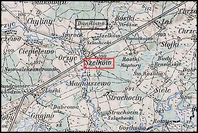
The Słownik Geograficzny Królestwa Polskiego i Innych Krajów Słowiańskich (Geographical Dictionary of the Kingdom of Poland and other Slavonic Countries) includes seven entries for Polish villages called Daniłowo. Two of these entries describe the village of Daniłowo in Maków Powiat, the village that belongs to Szelków parish.
Daniłowo and Surrounding Area – 1910
Third Military Mapping Survey of Austria-Hungary (ELTE Faculty of Informatics, Institute of Cartography and Geoinformatics); digital images, Lazarus ELTE (http://lazarus.elte.hu/hun/digkonyv/topo/200e/39-53.jpg: accessed 20 December 2025)
Source: Sulmierski, Filip, Bronisław Chlebowski, and Władysław Walewski, eds., Słownik Geograficzny Królestwa Polskiego i Innych Krajów Słowiańskich (Geographical Dictionary of the Kingdom of Poland and other Slavonic Countries) – Warsaw 1880, Volume I, page 901.
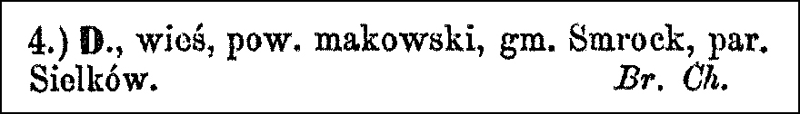
Click on the link for a PDF copy of the the Słownik Geograficzny entries for Daniłowo. Translated from the Polish, the first entry for Daniłowo (Szelków parish) reads:
4.) Daniłowo, a village in Maków powiat, Smrock gmina, Szelków parish. Bronisław Chlebowski
Translated from the Polish, the second entry for Daniłowo (Szelków parish) reads:
Daniłowo, a village in Maków powiat. A village belonging to the bishops of Płock. In 1578, Mateusz Piotrowicz, the village headman, paid taxes here on one łan (a unit of land area) and two homesteads.
The Dictionary of Polish Place Names (Nazwy Miejscowe Polski) explains the origin of place names in Poland and details how the place name changed over time.
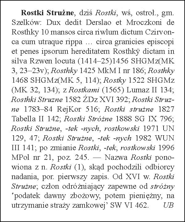
Volume XI of Nazwy Miejscowe Polski lists one place called Rostki-Strużne. This entry is for a village currently in the Masovian Voivodeship and which belongs to the Szelków parish. Today, the village of Rostki-Strużne is known simply as Rostki.
Nazwy Miejscowe Polski indicates that Rostki-Strużne was in the Szelków Gmina, Ostrołęka Voivodeship in the years 1975-1998. Mentions of the village include “Dux gave Derslao and Mroczko of Rosthky 10 manses around the stream called Czirvonca with both banks… near the bishop’s boundaries and next to their inherited land called Rosthky in the Rzwen forest” in (1414–25), Rosthky in 1425, Rosthky in 1468, Rostky in 1522, with Rostki in (1565), Rosthki Struzne in 1582, Rostki Struzne in 1783–84, Rostki strużne in 1827, Rostki Stróżne in 1888, Rostki Strużne, -tek -nych, rostkowski in 1971, Rostki Strużne, -tek -nych in 1982, after the name change Rostki, -tek, rostkowski in 1996.
The name Rostki is a repetition of the name Rostki (a village 8.5 kilometers northwest of Nasielsk) from where the recipients of the grant originated. From the 16th century, Rostki Strużne; the distinguishing element probably comes from stróżny “an old grain tax, later a monetary tax, for the maintenance of the castle guard’.
Source: Rymut, Kazimierz, Barbara Czopek-Kopciuch, and Urszula Bijak, eds., Nazwy Miejscowe Polski (Place Names of Poland) – Krakow 2005, Volume XI, page 90.
Click the link for a PDF copy of the Nazwy Miejscowe Polski entry for Rostki-Strużne. Translated rom the Polish, the entry reads:
Rostki Strużne, now Rostki, village, Ostrołęka voivodeship, Szelków gmina: Dux gave Derslao and Mroczko of Rosthky 10 manses around the stream called Czirvonca with both banks… near the bishop’s boundaries and next to their inherited land called Rosthky in the Rzwen forest (1414–25) 1456 SHGMz (MK 3, 23–23v); Rosthky 1425 MkM I no. 186; Rosthky 1468 SHGMz (MK 5, 114); Rostky 1522 SHGMz (MK 32, 134); with Rostki (1565) Lumaz II 134; Rosthki Struzne 1582 ŹDz XVI 392; Rostki Struzne 1783–84 RejKor 516; Rostki strużne 1827 Tabella II 142; Rostki Stróżne 1888 SG IX 796; Rostki Strużne, -tek -nych, rostkowski 1971 UN 129, 47; Rostki Strużne, -tek -nych 1982 WUN III 141; after the change Rostki, -tek, rostkowski 1996 MPol no. 21, item 245. – The name Rostki is a repetition of the name Rostki (1), from where the recipients of the grant originated, see the first record. From the 16th century, Rostki Strużne; the distinguishing element probably comes from stróżny “an old grain tax, later a monetary tax, for the maintenance of the castle guard” SW VI 462. Urszula Bijak


