
The following parishes were part of the Kolno Powiat at the beginning of the 20th Century: Borkowo, Burzyn, Dobryjałowo, Jedwabne, Kolno, Kuzie, Leman, Lipniki, Łyse, Mały Płock, Poryte, Przytuły, Romany, Stawiski, Turośl, Zalas, and Zbójna.
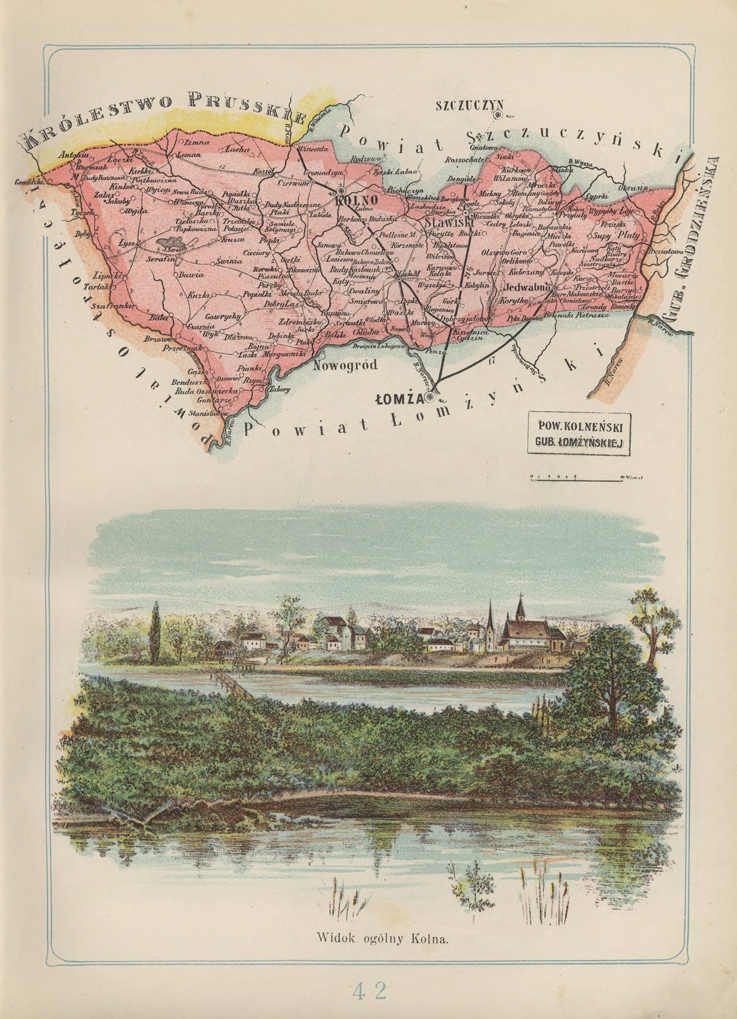
Józef Michał Bazewicz, Atlas geograficzny ilustrowany Królestwa Polskiego (Litografia B. A. Bukaty, Warsaw, 1907); digital images, Mapywig (http://igrek.amzp.pl/details.php?id=11767093 : accessed 13 Nov 2021).
The administrative structure of the parishes of Borkowo (NOTE: The parish church in Borkowo was established in 1918, separated from the parish of Mały Płock), Kolno and Mały Płock can be described as follows:
- 01 Jul 1569-03 Oct 1795: Village, Łomża Ziemia, Masovia Voivodeship, Province of Greater Poland, Polish-Lithuanian Commonwealth
- 04 Oct 1795-08 Jul 1807: Village, Kammerdepartement Białystok, Province of New East Prussia, Kingdom of Prussia
- 09 Jul 1807-08 Jun 1815: Village, Łomża Powiat, Łomża Department, Duchy of Warsaw
- 09 Jun 1815-15 Jan 1816: Village, Łomża Powiat, Łomża Department, Congress Kingdom of Poland
- 16 Jan 1816-06 Mar 1837: Village, Łomża Obwód, Augustów Voivodeship, Congress Kingdom of Poland
- 07 Mar 1837-10 Oct 1842: Village, Łomża Obwód, Augustów Gubernia, Congress Kingdom of Poland
- 11 Oct 1842 – 30 Dec 1866: Village, Łomża Powiat, Augustów Gubernia, Congress Kingdom of Poland
- 31 Dec 1866-23 Aug 1915: Village, Kolno Powiat, Łomża Gubernia, Congress Kingdom of Poland
- 24 Aug 1915-10 Nov 1918: Village, Łomża Powiat, General Government of Warsaw, German Empire
- 11 Nov 1918-31 Mar 1938: Village, Kolno Powiat, Białystok Voivodeship, Second Polish Republic
- 01 Apr 1938-03 Dec 1939: Village, Kolno Powiat, Warsaw Voivodeship, Second Polish Republic
- 04 Dec 1939-21 Jul 1941: Village, Białystok Oblast, Byelorussian SSR, USSR
- 22 Jul 1941-19 Sep 1944: Village, Bezirk Bialystok, German Reich
- 20 Sep 1944-15 Aug 1945: Village, Grodno Oblast, Byelorussian SSR, USSR
- 16 Aug 1945-18 Feb 1947: Village, Białystok Voivodeship, Provisional Government of National Unity
- 19 Feb 1947-21 Jul 1952: Village, Kolno Powiat, Białystok Voivodeship, Republic of Poland
- 22 Jul 1952-31 May 1975: Village, Kolno Powiat, Białystok Voivodeship, Polish People’s Republic
- 01 Jun 1975-30 Dec 1989: Village, Łomża Voivodeship, Polish People’s Republic
- 31 Dec 1989-30 Dec 1998: Village, Łomża Voivodeship, Third Polish Republic
- 31 Dec 1998-Present: Village, Kolno Powiat, Podlaskie Voivodeship, Third Polish Republic
The administrative structure of the parishes of Poryte, and Stawiski can be described as follows:
- 01 Jul 1569-03 Oct 1795: Village, Łomża Ziemia, Masovia Voivodeship, Province of Greater Poland, Polish-Lithuanian Commonwealth
- 04 Oct 1795-08 Jul 1807: Village, Kammerdepartement Białystok, Province of New East Prussia, Kingdom of Prussia
- 09 Jul 1807-08 Jun 1815: Village, Biebrza Powiat, Łomża Department, Duchy of Warsaw
- 09 Jun 1815-15 Jan 1816: Village, Biebrza Powiat, Łomża Department, Congress Kingdom of Poland
- 16 Jan 1816-06 Mar 1837: Village, Augustów Obwód, Augustów Voivodeship, Congress Kingdom of Poland
- 07 Mar 1837-10 Oct 1842: Village, Łomża Obwód, Augustów Gubernia, Congress Kingdom of Poland
- 11 Oct 1842 – 30 Dec 1866: Village, Łomża Powiat, Augustów Gubernia, Congress Kingdom of Poland
- 31 Dec 1866-23 Aug 1915: Village, Kolno Powiat, Łomża Gubernia, Congress Kingdom of Poland
- 24 Aug 1915-10 Nov 1918: Village, Łomża Powiat, General Government of Warsaw, German Empire
- 11 Nov 1918-31 Mar 1938: Village, Kolno Powiat, Białystok Voivodeship, Second Polish Republic
- 01 Apr 1938-07 Oct 1939: Village, Kolno Powiat, Warsaw Voivodeship, Second Polish Republic
- 04 Dec 1939-21 Jul 1941: Village, Białystok Oblast, Byelorussian SSR, USSR
- 22 Jul 1941-19 Sep 1944: Village, Bezirk Bialystok, German Reich
- 20 Sep 1944-15 Aug 1945: Village, Grodno Oblast, Byelorussian SSR, USSR
- 16 Aug 1945-18 Feb 1947: Village, Białystok Voivodeship, Provisional Government of National Unity
- 19 Feb 1947-21 Jul 1952: Village, Kolno Powiat, Białystok Voivodeship, Republic of Poland
- 22 Jul 1952-31 May 1975: Village, Kolno Powiat, Białystok Voivodeship, Polish People’s Republic
- 01 Jun 1975-30 Dec 1989: Village, Łomża Voivodeship, Polish People’s Republic
- 31 Dec 1989-30 Dec 1998: Village, Łomża Voivodeship, Third Polish Republic
- 31 Dec 1998-Present: Village, Kolno Powiat, Podlaskie Voivodeship, Third Polish Republic
The administrative structure of the parish of Romany can be described as follows:
- 01 Jul 1569-03 Oct 1795: Village, Wizna Ziemia, Masovia Voivodeship, Province of Greater Poland, Polish-Lithuanian Commonwealth
- 04 Oct 1795-08 Jul 1807: Village, Kammerdepartement Białystok, Province of New East Prussia, Kingdom of Prussia
- 09 Jul 1807-08 Jun 1815: Village, Biebrza Powiat, Łomża Department, Duchy of Warsaw
- 09 Jun 1815-15 Jan 1816: Village, Biebrza Powiat, Łomża Department, Congress Kingdom of Poland
- 16 Jan 1816-06 Mar 1837: Village, Augustów Obwód, Augustów Voivodeship, Congress Kingdom of Poland
- 07 Mar 1837-10 Oct 1842: Village, Łomża Obwód, Augustów Gubernia, Congress Kingdom of Poland
- 11 Oct 1842 – 30 Dec 1866: Village, Łomża Powiat, Augustów Gubernia, Congress Kingdom of Poland
- 31 Dec 1866-23 Aug 1915: Village, Kolno Powiat, Łomża Gubernia, Congress Kingdom of Poland
- 24 Aug 1915-10 Nov 1918: Village, Łomża Powiat, General Government of Warsaw, German Empire
- 11 Nov 1918-31 Mar 1938: Village, Kolno Powiat, Białystok Voivodeship, Second Polish Republic
- 01 Apr 1938-07 Oct 1939: Village, Kolno Powiat, Warsaw Voivodeship, Second Polish Republic
- 04 Dec 1939-21 Jul 1941: Village, Białystok Oblast, Byelorussian SSR, USSR
- 22 Jul 1941-19 Sep 1944: Village, Bezirk Bialystok, German Reich
- 20 Sep 1944-15 Aug 1945: Village, Grodno Oblast, Byelorussian SSR, USSR
- 16 Aug 1945-18 Feb 1947: Village, Białystok Voivodeship, Provisional Government of National Unity
- 19 Feb 1947-21 Jul 1952: Village, Kolno Powiat, Białystok Voivodeship, Republic of Poland
- 22 Jul 1952-31 May 1975: Village, Kolno Powiat, Białystok Voivodeship, Polish People’s Republic
- 01 Jun 1975-30 Dec 1989: Village, Łomża Voivodeship, Polish People’s Republic
- 31 Dec 1989-30 Dec 1998: Village, Łomża Voivodeship, Third Polish Republic
- 31 Dec 1998-Present: Village, Kolno Powiat, Podlaskie Voivodeship, Third Polish Republic
The administrative structure of the parish of Zbójna can be described as follows (NOTE: the parish of Zbójna was established in 1892. Prior to that, Zbójna belonged to the Nowogród parish):
- 01 Jul 1569-03 Oct 1795: Village, Łomża Ziemia, Masovia Voivodeship, Province of Greater Poland, Polish-Lithuanian Commonwealth
- 04 Oct 1795-08 Jul 1807: Village, Kammerdepartement Białystok, Province of New East Prussia, Kingdom of Prussia
- 09 Jul 1807-08 Jun 1815: Village, Łomża Powiat, Łomża Department, Duchy of Warsaw
- 09 Jun 1815-15 Jan 1816: Village, Łomża Powiat, Łomża Department, Congress Kingdom of Poland
- 16 Jan 1816-06 Mar 1837: Village, Łomża Obwód, Augustów Voivodeship, Congress Kingdom of Poland
- 07 Mar 1837-10 Oct 1842: Village, Łomża Obwód, Augustów Gubernia, Congress Kingdom of Poland
- 11 Oct 1842 – 30 Dec 1866: Village, Łomża Powiat, Augustów Gubernia, Congress Kingdom of Poland
- 31 Dec 1866-23 Aug 1915: Village, Kolno Powiat, Łomża Gubernia, Congress Kingdom of Poland
- 24 Aug 1915-10 Nov 1918: Village, Łomża Powiat, General Government of Warsaw, German Empire
- 11 Nov 1918-31 Mar 1938: Village, Kolno Powiat, Białystok Voivodeship, Second Polish Republic
- 01 Apr 1938-07 Oct 1939: Village, Kolno Powiat, Warsaw Voivodeship, Second Polish Republic
- 04 Dec 1939-21 Jul 1941: Village, Białystok Oblast, Byelorussian SSR, USSR
- 22 Jul 1941-19 Sep 1944: Village, Bezirk Bialystok, German Reich
- 20 Sep 1944-15 Aug 1945: Village, Grodno Oblast, Byelorussian SSR, USSR
- 16 Aug 1945-18 Feb 1947: Village, Białystok Voivodeship, Provisional Government of National Unity
- 19 Feb 1947-21 Jul 1952: Village, Łomża Powiat, Białystok Voivodeship, Republic of Poland
- 22 Jul 1952-31 May 1975: Village, Łomża Powiat, Białystok Voivodeship, Polish People’s Republic
- 01 Jun 1975-30 Dec 1989: Village, Łomża Voivodeship, Polish People’s Republic
- 31 Dec 1989-30 Dec 1998: Village, Łomża Voivodeship, Third Polish Republic
- 31 Dec 1998-Present: Village, Łomża Powiat, Podlaskie Voivodeship, Third Polish Republic
The administrative structure of the parishes of Burzyn, Dobryjałowo, Jedwabne, and Przytuły can be described as follows:
- 01 Jul 1569-03 Oct 1795: Village, Wizna Ziemia, Masovia Voivodeship, Province of Greater Poland, Polish-Lithuanian Commonwealth
- 04 Oct 1795-08 Jul 1807: Village, Kammerdepartement Białystok, Province of New East Prussia, Kingdom of Prussia
- 09 Jul 1807-08 Jun 1815: Village, Biebrza Powiat, Łomża Department, Duchy of Warsaw
- 09 Jun 1815-15 Jan 1816: Village, Biebrza Powiat, Łomża Department, Congress Kingdom of Poland
- 16 Jan 1816-06 Mar 1837: Village, Augustów Obwód, Augustów Voivodeship, Congress Kingdom of Poland
- 07 Mar 1837-10 Oct 1842: Village, Łomża Obwód, Augustów Gubernia, Congress Kingdom of Poland
- 11 Oct 1842 – 30 Dec 1866: Village, Łomża Powiat, Augustów Gubernia, Congress Kingdom of Poland
- 31 Dec 1866-23 Aug 1915: Village, Kolno Powiat, Łomża Gubernia, Congress Kingdom of Poland
- 24 Aug 1915-10 Nov 1918: Village, Łomża Powiat, General Government of Warsaw, German Empire
- 11 Nov 1918-31 Mar 1938: Village, Kolno Powiat, Białystok Voivodeship, Second Polish Republic
- 01 Apr 1938-07 Oct 1939: Village, Kolno Powiat, Warsaw Voivodeship, Second Polish Republic
- 04 Dec 1939-21 Jul 1941: Village, Białystok Oblast, Byelorussian SSR, USSR
- 22 Jul 1941-19 Sep 1944: Village, Bezirk Bialystok, German Reich
- 20 Sep 1944-15 Aug 1945: Village, Grodno Oblast, Byelorussian SSR, USSR
- 16 Aug 1945-18 Feb 1947: Village, Białystok Voivodeship, Provisional Government of National Unity
- 19 Feb 1947-21 Jul 1952: Village, Łomża Powiat, Białystok Voivodeship, Republic of Poland
- 22 Jul 1952-31 May 1975: Village, Łomża Powiat, Białystok Voivodeship, Polish People’s Republic
- 01 Jun 1975-30 Dec 1989: Village, Łomża Voivodeship, Polish People’s Republic
- 31 Dec 1989-30 Dec 1998: Village, Łomża Voivodeship, Third Polish Republic
- 31 Dec 1998-Present: Village, Łomża Powiat, Podlaskie Voivodeship, Third Polish Republic
The administrative structure of the parishes of Kuzie (established on 01 Nov 1921), Leman (established on 22 Jun 1906), Lipniki, Łyse, Turośl and Zalas (established on 01 Apr 1903) can be described as follows:
- 01 Jul 1569-03 Oct 1795: Village, Łomża Ziemia, Masovia Voivodeship, Province of Greater Poland, Polish-Lithuanian Commonwealth
- 04 Oct 1795-08 Jul 1807: Village, Kammerdepartement Białystok, Province of New East Prussia, Kingdom of Prussia
- 09 Jul 1807-08 Jun 1815: Village, Łomża Powiat, Łomża Department, Duchy of Warsaw
- 09 Jun 1815-15 Jan 1816: Village, Łomża Powiat, Łomża Department, Congress Kingdom of Poland
- 16 Jan 1816-06 Mar 1837: Village, Łomża Obwód, Augustów Voivodeship, Congress Kingdom of Poland
- 07 Mar 1837-10 Oct 1842: Village, Łomża Obwód, Augustów Gubernia, Congress Kingdom of Poland
- 11 Oct 1842 – 30 Dec 1866: Village, Łomża Powiat, Augustów Gubernia, Congress Kingdom of Poland
- 31 Dec 1866-23 Aug 1915: Village, Kolno Powiat, Łomża Gubernia, Congress Kingdom of Poland
- 24 Aug 1915-10 Nov 1918: Village, Łomża Powiat, General Government of Warsaw, German Empire
- 11 Nov 1918-31 Mar 1938: Village, Kolno Powiat, Białystok Voivodeship, Second Polish Republic
- 01 Apr 1938-07 Oct 1939: Village, Kolno Powiat, Warsaw Voivodeship, Second Polish Republic
- 04 Dec 1939-21 Jul 1941: Village, Białystok Oblast, Byelorussian SSR, USSR
- 22 Jul 1941-19 Sep 1944: Village, Bezirk Bialystok, German Reich
- 20 Sep 1944-15 Aug 1945: Village, Grodno Oblast, Byelorussian SSR, USSR
- 16 Aug 1945-18 Feb 1947: Village, Białystok Voivodeship, Provisional Government of National Unity
- 19 Feb 1947-21 Jul 1952: Village, Kolno Powiat, Białystok Voivodeship, Republic of Poland
- 22 Jul 1952-31 May 1975: Village, Kolno Powiat, Białystok Voivodeship, Polish People’s Republic
- 01 Jun 1975-30 Dec 1989: Village, Ostrołęka Voivodeship, Polish People’s Republic
- 31 Dec 1989-30 Dec 1998: Village, Ostrołęka Voivodeship, Third Polish Republic
- 31 Dec 1998-Present: Village, Ostrołęka Powiat, Mazowieckie Voivodeship, Third Polish Republic
Copyright © 2021-2026 by Stephen J. Danko


