
After the Napoleonic Wars in Europe, a group of ambassadors from Europe met in Vienna in May 1814 to settle the borders of the European states. The Final Act of the Congress of Vienna was signed on 09 June 1815 and gave Russia most of the Duchy of Warsaw, which was renamed the Kingdom of Poland. Herein, the Kingdom of Poland created by the Congress of Vienna is referred to as the Congress Kingdom of Poland to distinguish it from the Kingdom of Poland that existed under the Piast (1025-1385) and Jagellon (1385-1569) dynasties.
Officially, the Congress Kingdom of Poland was allowed to have a significant amount of political autonomy, although the real political authority lay in the hands of the Russian Empire.
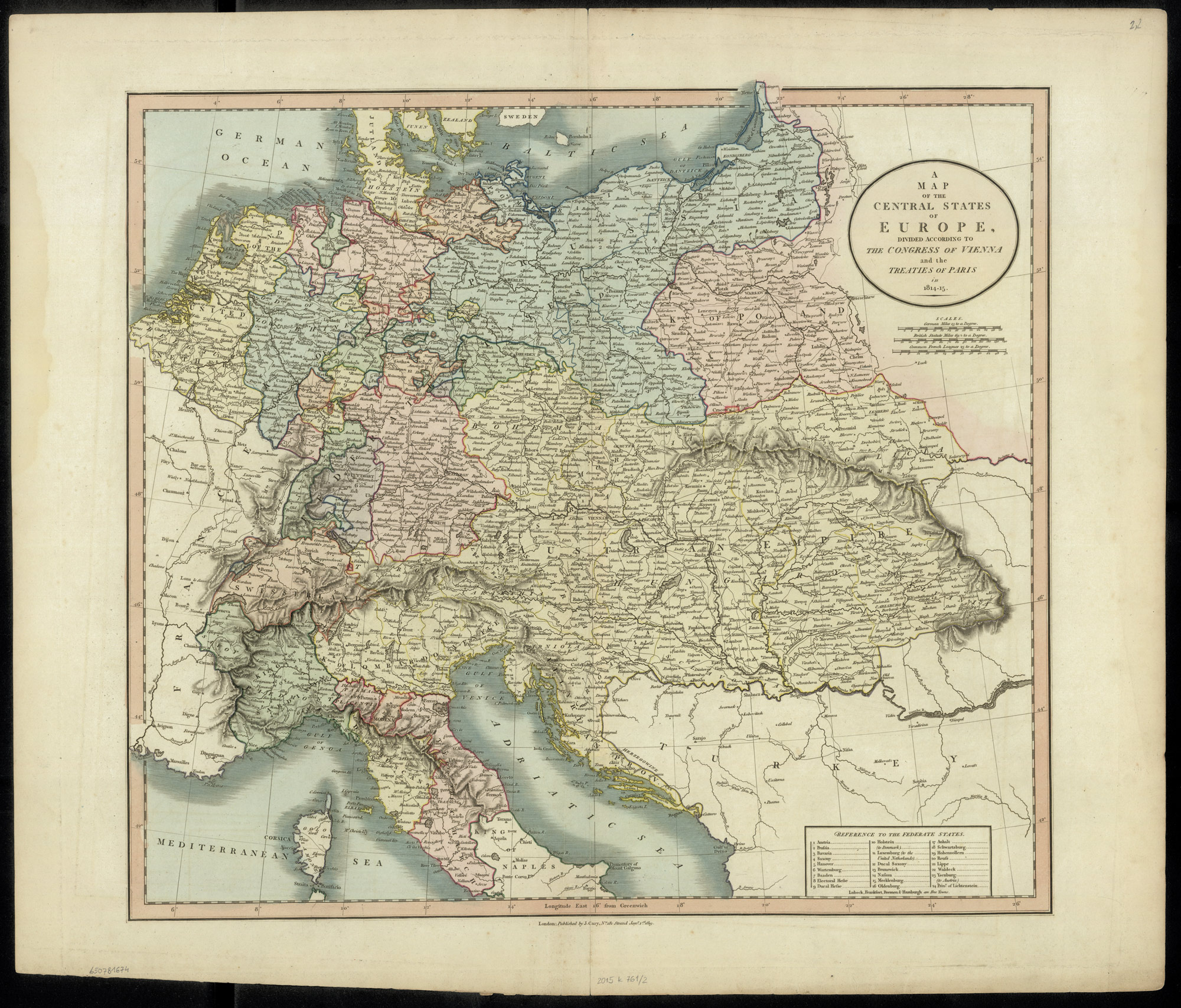
John Cary, A Map of the Central States of Europe, Divided According to the Congress of Vienna and the Treaties of Paris in 1814-1815 (J. Cary, Engraver & Map seller, London, England, 1819); digital images, Polona Digital Library (http://polona.pl/item/47509069/ : accessed 06 January 2019).
The administrative structure of the Congress Kingdom of Poland changed several times during its existence. Initially divided into Departments (a vestige of the administrative structure of the Duchy of Warsaw), the Congress Kingdom of Poland was reformed into more traditional voivodeships, obwóds, and powiats on 16 January 1816.
On 07 March 1837, voivodeships were renamed gubernias to further integrate the administrative structure of the Congress Kingdom of Poland into the administrative structure of the Russian Empire.
On 15 Jun 1841, the Krakow Gubernia was renamed the Kielce Gubernia and, effective 10 Nov 1942, powiats were renamed okręgs, and obwóds were renamed powiats.
During the period of 1815-1844, the administrative divisions of the Congress Kingdom of Poland changed as follows:
09 June 1815
- Bydgoszcz Department (Powiats: Brześć, Bydgoszcz, Chełmno, Inowrocław, Kamień, Kowal, Michałowo, Radziejów, Toruń, Wałecki)
- Kalisz Department (Powiats: Częstochowa, Kalisz, Konin, Odolanów, Ostrzeszów, Piotrków, Radomsko, Sieradz, Szadeck, Warta, Wieluń)
- Kraków Department (Powiats: Hebdów, Jędrzejów, Kraków, Krzeszowice, Lelowska, Miechów, Olkusz, Pilica, Stopnica, Szydłów, Skalbmierz)
- Łomża Department (Powiats: Biebrza, Dąbrowa, Kalwaria, Łomża, Mariampol, Tykocin, Wigry)
- Lublin Department (Powiats: Chełm, Hrubiezów, Kazimierz, Kraśnik, Lubartów, Lublin, Tomaszów, Tarnogród, Zamość)
- Płock Department (Powiats: Lipno, Mława, Ostrołęka, Przasnysz, Pułtusk, Wyszogród)
- Poznań Department (Powiats: Babimost, Gniezno, Kościan, Krobia, Krotoszyn, Międzyrzecz, Oborniki, Powidz, Poznań, Pyzdry, Środa, Śrem, Wągrowiec, Wschowa)
- Radom Department (Powiats: Kielce, Końskie, Kozienice, Opatów, Opoczno, Radom, Sandomierz, Solec, Staszów, Szydłowiec)
- Siedlce Department (Biała, Garwolin, Łosice, Łuków, Radzyń, Siedlce, Węgrów, Żelechów, Włodawa)
- Warsaw Department (Powiats: Błonie, Brzeziny, Czersk, Gostynin, Łęczyca, Orłów, Rawa, Siennica, Sochaczew, Stanisławów, Warsaw, Zgierz)
16 January 1816
- Augustów Voivodeship (Obwóds: Augustów, Kalwaria, Łomża, Mariampol, and Sejny)
- Kalisz Voivodeship (Obwóds: Kalisz, Konin, Piotrków, Sieradz, and Wielun)
- Kraków Voivodeship (Obwóds: Kielce, Miechów, Olkusz, and Stopnica)
- Lublin Voivodeship (Obwóds: Hrubieszów, Janów, Krasnystaw,and Lublin)
- Masovian Voivodeship (Obwóds: Brześć, Kutno, Łęczyca, Łowicz, Minsk, and Warszawa)
- Płock Voivodeship (Obwóds: Lipno, Mława, Ostrołęka, Płock, Przasnysz, and Pułtusk)
- Podlaski Voivodeship (Obwóds: Biała, Łuków, Siedlce, and Radzyń)
- Sandomierz Voivodeship (Obwóds: Końskie, Opatów, Radom, and Sandomierz)
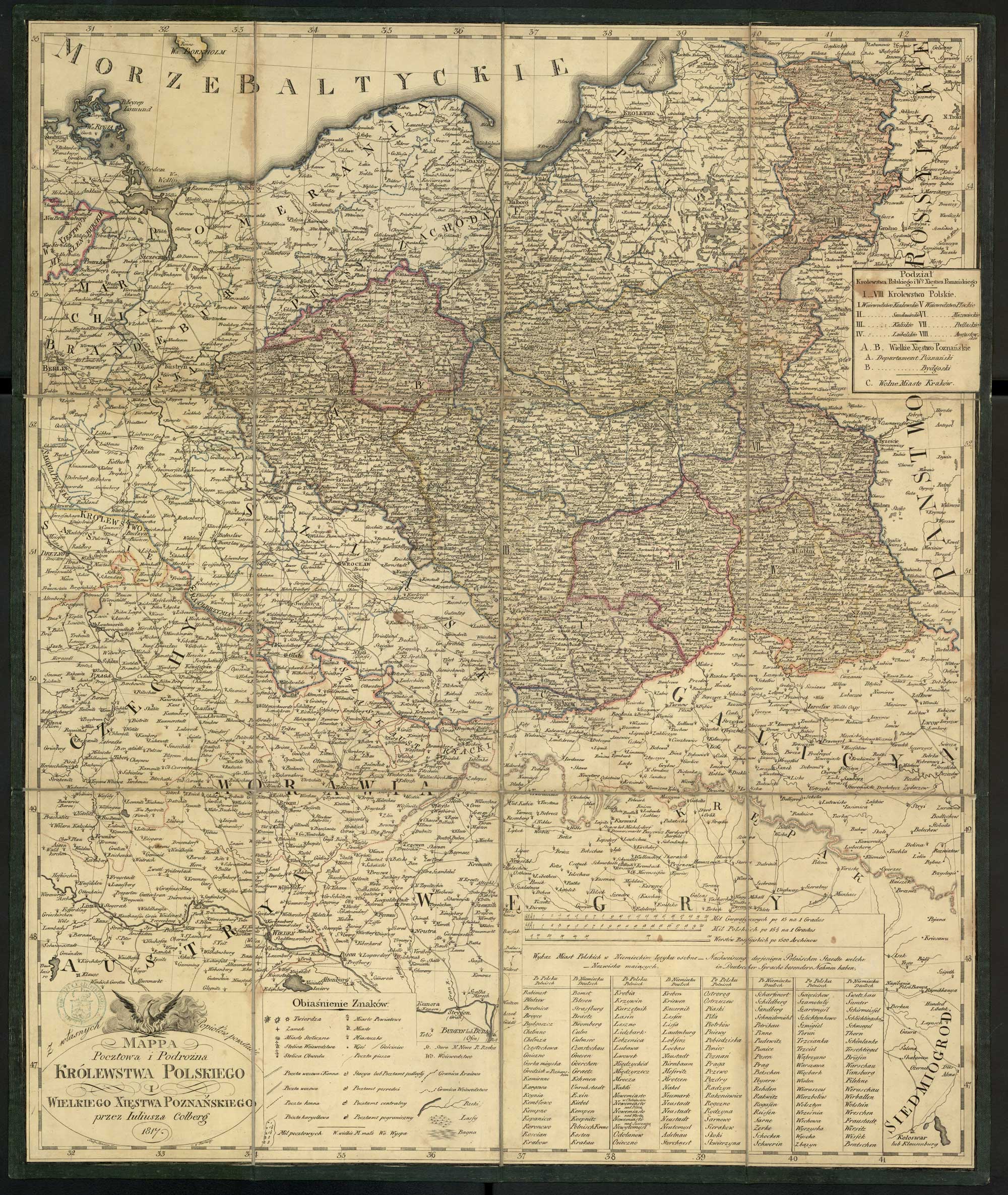
Juliusz Kolberg, Mappa Pocztowa i Podrożna Królestwa Polskiego i Wielkiego Xsięstwa Poznańskiego (Publisher unknown, Place unknown, 1817); digital images, Polona Digital Library (http://polona.pl/item/32506788/ : accessed 06 January 2019).
07 March 1837
- Augustów Gubernia (Obwóds: Augustów, Kalwaria, Łomża, Mariampol, and Sejny)
- Kalisz Gubernia (Obwóds: Kalisz, Konin, Piotrków, Sieradz, and Wielun)
- Kraków Gubernia (Obwóds: Kielce, Miechów, Olkusz, and Stopnica)
- Lublin Gubernia (Obwóds: Hrubieszów, Janów, Krasnystaw,and Lublin)
- Masovian Gubernia (Obwóds: Brześć, Kutno, Łęczyca, Łowicz, Minsk, and Warszawa)
- Płock Gubernia (Obwóds: Lipno, Mława, Ostrołęka, Płock, Przasnysz, and Pułtusk)
- Podlaski Gubernia (Obwóds: Biała, Łuków, Siedlce, and Radzyń)
- Sandomierz Gubernia (Obwóds: Końskie, Opatów, Radom, and Sandomierz)
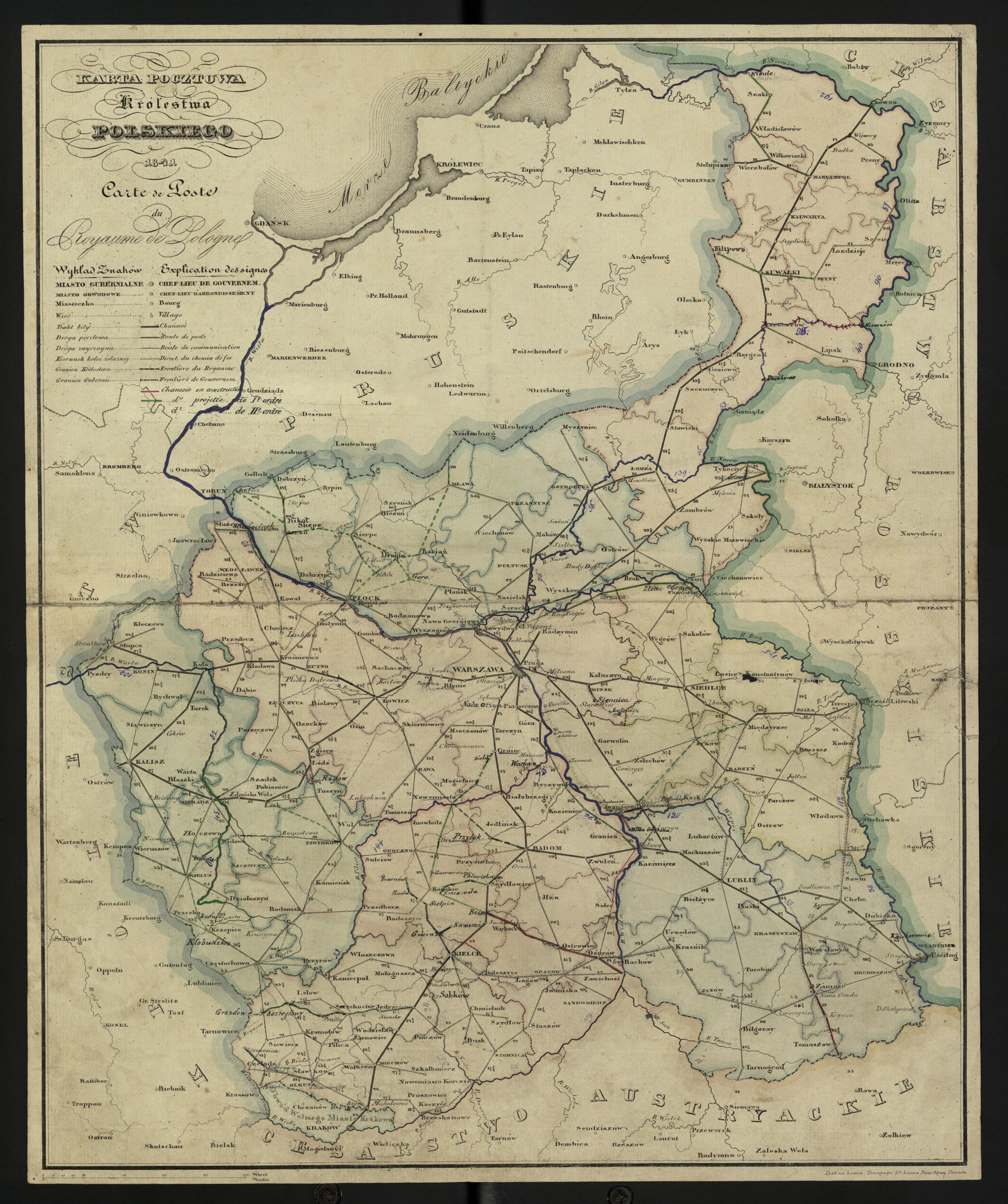
Congress Kingdom of Poland – 1841
Author unknown, Karta Pocztowa Królestwa Polskiego (Publisher unknown, Place unknown, 1841); digital images, Polona Digital Library (http://polona.pl/item/7957788/ : accessed 06 January 2019).
15 Jun 1841
- Augustów Gubernia (Obwóds: Augustów, Kalwaria, Łomża, Mariampol, and Sejny)
- Kalisz Gubernia (Obwóds: Kalisz, Konin, Piotrków, Sieradz, and Wielun)
- Kielce Gubernia (Obwóds: Kielce, Miechów, Olkusz, and Stopnica)
- Lublin Gubernia (Obwóds: Hrubieszów, Janów, Krasnystaw,and Lublin)
- Masovian Gubernia (Obwóds: Brześć, Kutno, Łęczyca, Łowicz, Minsk, and Warszawa)
- Płock Gubernia (Obwóds: Lipno, Mława, Ostrołęka, Płock, Przasnysz, and Pułtusk)
- Podlaski Gubernia (Obwóds: Biała, Łuków, Siedlce, and Radzyń)
- Sandomierz Gubernia (Obwóds: Końskie, Opatów, Radom, and Sandomierz)
10 Nov 1842
- Augustów Gubernia (Powiats: Augustów, Kalwaria, Łomża, Mariampol, and Sejny)
- Kalisz Gubernia (Powiats: Kalisz, Konin, Piotrków, Sieradz, and Wielun)
- Kielce Gubernia (Powiats: Kielce, Miechów, Olkusz, and Stopnica)
- Lublin Gubernia (Powiats: Hrubieszów, Janów, Krasnystaw,and Lublin)
- Masovian Gubernia (Powiats: Brześć, Kutno, Łęczyca, Łowicz, Minsk, and Warszawa)
- Płock Gubernia (Powiats: Lipno, Mława, Ostrołęka, Płock, Przasnysz, and Pułtusk)
- Podlaski Gubernia (Powiats: Biała, Łuków, Siedlce, and Radzyń)
- Sandomierz Gubernia (Powiats: Końskie, Opatów, Radom, and Sandomierz)
REFERENCES
Trzebiński, Wojciech, and Adam Borkiewicz. 1956. Podziały administracyjne Królestwa Polskiego w okresie 1815-1918 r.: (zarys historyczny). Warszawa: Polska Akademia Nauk. Instytut Geografii. Image copy. Digital Repository of Scientific Institutes (http://rcin.org.pl/publication/50581 : 2019).
Borkiewicz, Adam Józef. 1956. Podziały administracyjne Królestwa Polskiego w okresie 1815-1918 r.: mapy. Warszawa: Polska Akademia Nauk. Instytut Geografii. Image copy. Digital Repository of Scientific Institutes (http://rcin.org.pl/publication/50583 : 2019).
Copyright © 2019-2026 by Stephen J. Danko


