
The following parishes were part of the Mława Powiat at the beginning of the 20th Century: Bogurzyn, Dąbrowa, Stare Dłutowo, Grzebsk, Janowiec, Kuczbork, Kuklin, Lipowiec Kościelny, Lubowidz, Łęg, Mława, Mława-Wólka, Radzanów, Sarnowo, Stupsk, Strzegowo, Szreńsk, Szydłowo, Unierzyż, Wieczfnia Kościelna, Wojnówka, Wyszyny Kościelne, Zgliczyn, Zielona, Zieluń, Żmijewo Kościelne, and Żurominek.
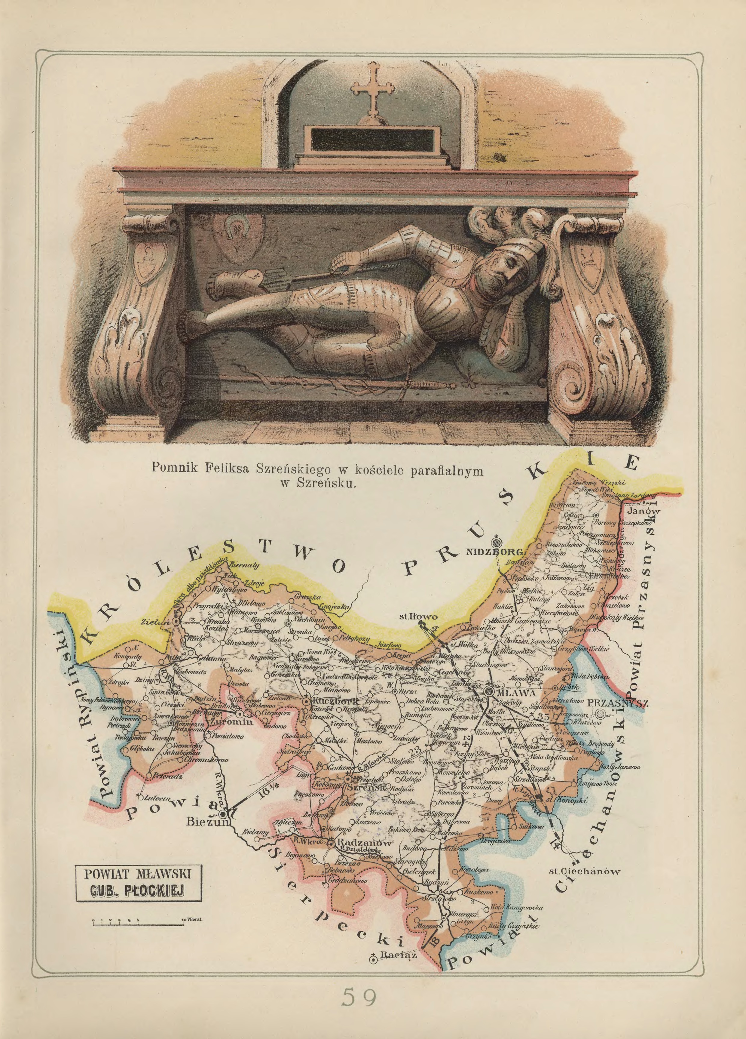
Mława Powiat in the Płock Gubernia – 1907
Józef Michał Bazewicz, Atlas geograficzny ilustrowany Królestwa Polskiego (Litografia B. A. Bukaty, Warsaw, 1907); digital images, Mapywig (http://igrek.amzp.pl/details.php?id=11767110 : accessed 02 February 2019).
The administrative structure of the parishes of Bogurzyn, Dąbrowa, Grzebsk, Kuklin, Lipowiec Kościelny, Łęg, Mława, Mława-Wólka (established 28 Jan 1912) Radzanów, Stupsk, Strzegowo, Szreńsk, Szydłowo, Unierzyż, Wieczfnia Kościelna, Wojnówka, Wyszyny Kościelne, Zgliczyn, Żmijewo Kościelne, and Żurominek can be described as follows:
- 01 Jul 1569-03 Oct 1795: Village, Zawkrze Ziemia, Płock Voivodeship, Crown of the Kingdom of Poland, Polish-Lithuanian Commonwealth
- 04 Oct 1795-08 Jul 1807: Village, Kammerdepartement Płock, Province of New East Prussia, Kingdom of Prussia
- 09 Jul 1807-08 Jun 1815: Village, Mława Powiat, Płock Department, Duchy of Warsaw
- 09 Jun 1815-15 Jan 1816: Village, Mława Powiat, Płock Department, Congress Kingdom of Poland
- 16 Jan 1816-06 Mar 1837: Village, Mława Obwód, Płock Voivodeship, Congress Kingdom of Poland
- 07 Mar 1837-10 Nov 1842: Village, Mława Obwód, Płock Gubernia, Congress Kingdom of Poland
- 11 Nov 1842-17 Oct 1915: Village, Mława Powiat, Płock Gubernia, Congress Kingdom of Poland
- 18 Oct 1915-10 Nov 1918: Village, Mława Powiat, General Government of Warsaw, German Empire
- 11 Nov 1918-31 Aug 1939: Village, Mława Powiat, Warsaw Voivodeship, Second Polish Republic
- 01 Sep 1939-27 Jun 1945: Village, Landkreis Mielau, Regierungsbezirk Zichenau, Province of East Prussia, German Reich
- 28 Jun 1945-21 Jul 1952: Village, Mława Powiat, Warsaw Voivodeship, Republic of Poland
- 22 Jul 1952-31 May 1975: Village, Mława Powiat, Warsaw Voivodeship, Polish People’s Republic
- 01 Jun 1975-30 Dec 1989: Village, Ciechanów Voivodeship, Polish People’s Republic
- 31 Dec 1989-30 Dec 1998: Village, Ciechanów Voivodeship, Third Polish Republic
- 31 Dec 1998-Present: Village, Mława Powiat, Masovian Voivodeship, Third Polish Republic
The administrative structure of the parish of Janowiec can be described as follows:
- 01 Jul 1569-03 Oct 1795: Village, Zawkrze Ziemia, Płock Voivodeship, Crown of the Kingdom of Poland, Polish-Lithuanian Commonwealth
- 04 Oct 1795-08 Jul 1807: Village, Kammerdepartement Płock, Province of New East Prussia, Kingdom of Prussia
- 09 Jul 1807-08 Jun 1815: Village, Mława Powiat, Płock Department, Duchy of Warsaw
- 09 Jun 1815-15 Jan 1816: Village, Mława Powiat, Płock Department, Congress Kingdom of Poland
- 16 Jan 1816-06 Mar 1837: Village, Mława Obwód, Płock Voivodeship, Congress Kingdom of Poland
- 07 Mar 1837-10 Nov 1842: Village, Mława Obwód, Płock Gubernia, Congress Kingdom of Poland
- 11 Nov 1842-17 Oct 1915: Village, Mława Powiat, Płock Gubernia, Congress Kingdom of Poland
- 18 Oct 1915-10 Nov 1918: Village, Mława Powiat, General Government of Warsaw, German Empire
- 11 Nov 1918-31 Aug 1939: Village, Mława Powiat, Warsaw Voivodeship, Second Polish Republic
- 01 Sep 1939-27 Jun 1945: Village, Landkreis Mielau, Regierungsbezirk Zichenau, Province of East Prussia, German Reich
- 28 Jun 1945-21 Jul 1952: Village, Mława Powiat, Warsaw Voivodeship, Republic of Poland
- 22 Jul 1952-31 May 1975: Village, Mława Powiat, Warsaw Voivodeship, Polish People’s Republic
- 01 Jun 1975-30 Dec 1989: Village, Olstyn Voivodeship, Polish People’s Republic
- 31 Dec 1989-30 Dec 1998: Village, Olsztyn Voivodeship, Third Polish Republic
- 31 Dec 1998-Present: Village, Nidzica Powiat, Warmian-Masurian Voivodeship, Third Polish Republic
The administrative structure of the parishes of Kuczbork, Lubowidz, Sarnowo, Zielona, and Zieluń can be described as follows:
- 01 Jul 1569-03 Oct 1795: Village, Zawkrze Ziemia, Płock Voivodeship, Crown of the Kingdom of Poland, Polish-Lithuanian Commonwealth
- 04 Oct 1795-08 Jul 1807: Village, Kammerdepartement Płock, Province of New East Prussia, Kingdom of Prussia
- 09 Jul 1807-08 Jun 1815: Village, Mława Powiat, Płock Department, Duchy of Warsaw
- 09 Jun 1815-15 Jan 1816: Village, Mława Powiat, Płock Department, Congress Kingdom of Poland
- 16 Jan 1816-06 Mar 1837: Village, Mława Obwód, Płock Voivodeship, Congress Kingdom of Poland
- 07 Mar 1837-10 Nov 1842: Village, Mława Obwód, Płock Gubernia, Congress Kingdom of Poland
- 11 Nov 1842-17 Oct 1915: Village, Mława Powiat, Płock Gubernia, Congress Kingdom of Poland
- 18 Oct 1915-10 Nov 1918: Village, Mława Powiat, General Government of Warsaw, German Empire
- 11 Nov 1918-31 Aug 1939: Village, Mława Powiat, Warsaw Voivodeship, Second Polish Republic
- 01 Sep 1939-27 Jun 1945: Village, Landkreis Mielau, Regierungsbezirk Zichenau, Province of East Prussia, German Reich
- 28 Jun 1945-21 Jul 1952: Village, Mława Powiat, Warsaw Voivodeship, Republic of Poland
- 22 Jul 1952-31 May 1975: Village, Mława Powiat, Warsaw Voivodeship, Polish People’s Republic
- 01 Jun 1975-30 Dec 1989: Village, Ciechanów Voivodeship, Polish People’s Republic
- 31 Dec 1989-30 Dec 1998: Village, Ciechanów Voivodeship, Third Polish Republic
- 31 Dec 1998-Present: Village, Żuromin Powiat, Masovian Voivodeship, Third Polish Republic
The administrative structure of the parish of Stare Dłutowo can be described as follows:
- 01 Jul 1569-22 Jan 1793: Village, Zawkrze Ziemia, Płock Voivodeship, Crown of the Kingdom of Poland, Polish-Lithuanian Commonwealth
- 23 Jan 1793-08 Jul 1807: Village, Kammerdepartement Płock, Province of New East Prussia, Kingdom of Prussia
- 09 Jul 1807-08 Jun 1815: Village, Mława Powiat, Płock Department, Duchy of Warsaw
- 09 Jun 1815-15 Jan 1816: Village, Mława Powiat, Płock Department, Congress Kingdom of Poland
- 16 Jan 1816-06 Mar 1837: Village, Mława Obwód, Płock Voivodeship, Congress Kingdom of Poland
- 07 Mar 1837-10 Nov 1842: Village, Mława Obwód, Płock Gubernia, Congress Kingdom of Poland
- 11 Nov 1842-17 Oct 1915: Village, Mława Powiat, Płock Gubernia, Congress Kingdom of Poland
- 18 Oct 1915-10 Nov 1918: Village, Mława Powiat, General Government of Warsaw, German Empire
- 11 Nov 1918-31 Aug 1939: Village, Mława Powiat, Warsaw Voivodeship, Second Polish Republic
- 01 Sep 1939-27 Jun 1945: Village, Landkreis Mielau, Regierungsbezirk Zichenau, Province of East Prussia, German Reich
- 28 Jun 1945-21 Jul 1952: Village, Mława Powiat, Warsaw Voivodeship, Republic of Poland
- 22 Jul 1952-31 May 1975: Village, Mława Powiat, Warsaw Voivodeship, Polish People’s Republic
- 01 Jun 1975-30 Dec 1989: Village, Ciechanów Voivodeship, Polish People’s Republic
- 31 Dec 1989-30 Dec 1998: Village, Ciechanów Voivodeship, Third Polish Republic
- 31 Dec 1998-Present: Village, Działdowo Powiat, Warmia-Masuria Voivodeship, Third Polish Republic
Copyright © 2019 by Stephen J. Danko


