
In 1845, for the “general good of the country”, the borders of six gubernias in the Congress Kingdom of Poland were changed. The Kalisz Gubernia and the Masovian Gubernia were combined to form the Warsaw Gubernia with its seat in Warsaw. The Podlaski Gubernia and the Lublin Gubernia were combined to form the Lublin Gubernia with its seat in Lublin. The Sandomierz Gubernia and the Kielce Gubernia were combined to form the Radom Gubernia with its seat in Radom. The Augustów Gubernia remained unchanged with its seat in Suwalki, and the Płock Gubernia remained unchanged with its seat in Płock. The eight gubernias that had existed in the Congress Kingdom of Poland had been reduced to five.
01 January 1845
From 01 January 1845 until 30 December 1866, the administrative divisions of the Congress Kingdom of Poland were as follows:
- Augustów Gubernia (Powiats: Augustów, Kalwaria, Łomża, Mariampol, and Sejny)
- Lublin Gubernia (Powiats: Biała, Hrubieszów, Janów, Krasnystaw, Lublin, Łuków, Siedlce, and Radzyń)
- Płock Gubernia (Powiats: Lipno, Mława, Ostrołęka, Płock, Przasnysz, and Pułtusk)
- Radom Gubernia (Powiats: Kielce, Koński, Miechów, Olkusz, Opatów, Radom, Sandomierz, and Stopnica)
- Warsaw Gubernia (Powiats: Brześć, Kalisz, Konin, Kutno, Łęczyca, Łowicz, Minsk, Piotrków, Sieradz, Warsaw, and Wielun)
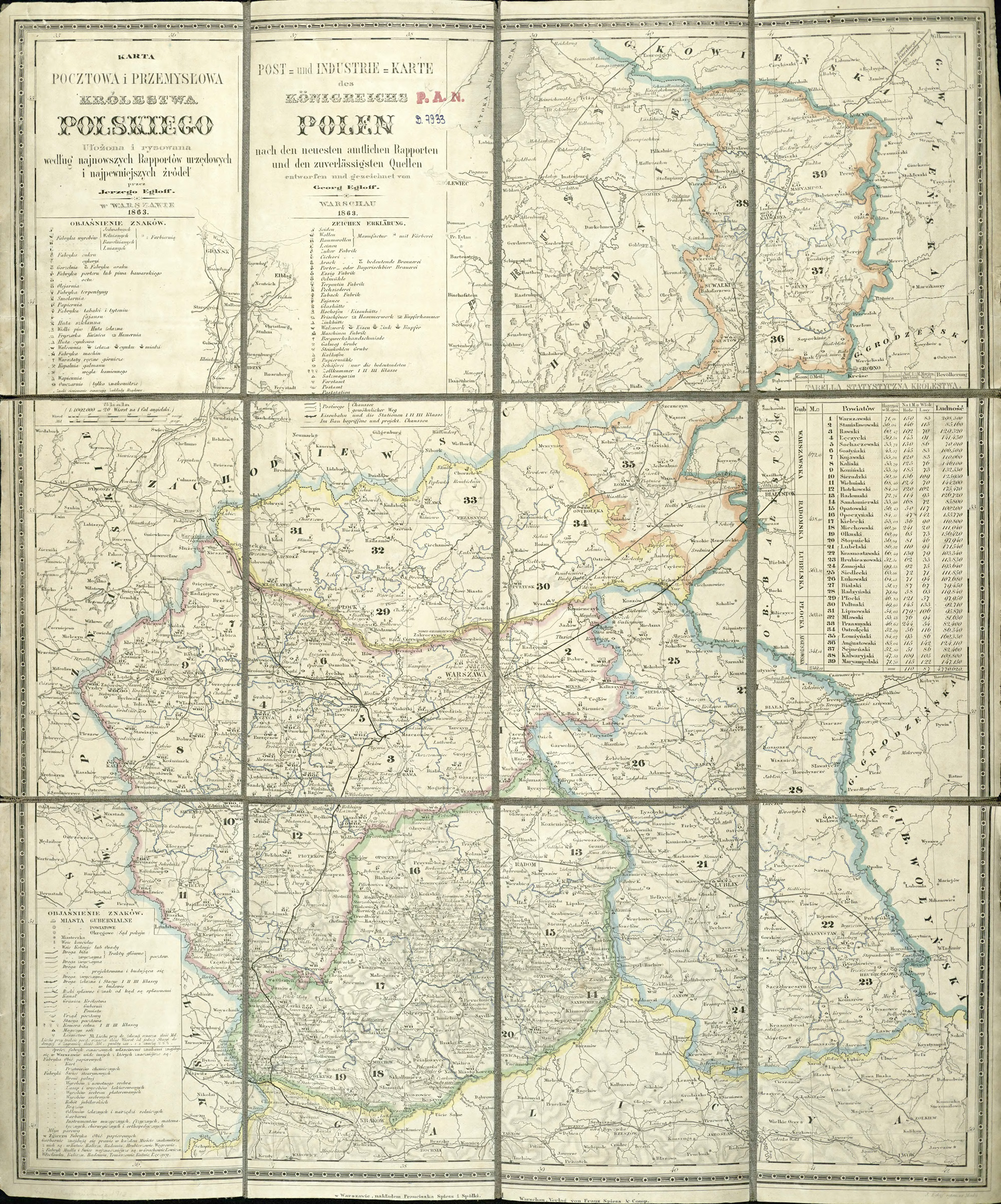
Congress Kingdom of Poland – 1845-1866
Jarzy Egloff, Karta pocztowa i przemysłowa Królestwa Polskiego (Franciszek Spiess and Company, Warsaw, 1863); digital images, Digital Repository of Scientific Institutes (http://rcin.org.pl/publication/51292 : accessed 10 February 2019).
31 December 1866
After the failure of the January Uprising (1863-1864), larger gubernias in the Congress Kingdom of Poland were divided into smaller ones. From 31 December 1866 to 10 March 1879, the administrative division of the Congress Kingdom of Poland was as follows:
- Kalisz Gubernia (Powiats: Kalisz, Koło, Konin, Łęczyca, Sieradz, Słupca, Turek, and Wieluń)
- Kielce Gubernia (Powiats: Jędrzejów, Kielce, Miechów, Olkusz, Pińczów, Stopnica, and Włoszczowa)
- Lublin Gubernia (Powiats: Biłgoraj, Chełm, Hrubieszów, Janów Lubelski, Krasnystaw, Lubartów, Lublin, Puławy [Nowa Aleksandria], Tomaszów Lubelski, Zamość)
- Łomża Gubernia (Powiats: Kolno, Łomża, Maków Mazowiecki, Ostrołęka, Ostrów Mazowiecka, Pułtusk, Szczuczyn, and Wysokie Mazowieckie)
- Piotrków Gubernia (Powiats: Będziń, Brzeziny, Częstochowa, Łask, Łódź, Piotrków Trybunalski, Radomsko, and Rawa Mazowiecka)
- Płock Gubernia (Powiats: Ciechanów, Lipno, Mława, Płock, Płońsk, Przasnysz, Rypin, and Sierpc)
- Radom Gubernia (Powiats: Iłża, Końskie, Kozienice, Opatów, Opoczno, Radom, and Sandomierz)
- Siedlce Gubernia (Powiats: Biała Podlaska, Garwolin, Konstantynów, Łuków, Radzyń, Podlaski, Siedlce, Sokołów Podlaski, Węgrów, and Włodawa)
- Suwalki Gubernia (Powiats: Augustów, Kalwarija, Kudirkos Naumiestis [Władysławów], Marijampolė, Sejny, Suwałki, and Vilkaviškis)
- Warsaw Gubernia (Powiats: Błonie, Góra Kalwarya, Gostyń, Grójec, Kutno, Łowicz, Mińsk Mazowiecki, Radzieje / later Nieszawa, Radzymin, Skierniewice, Sochaczew, Warsaw, and Włocławek)
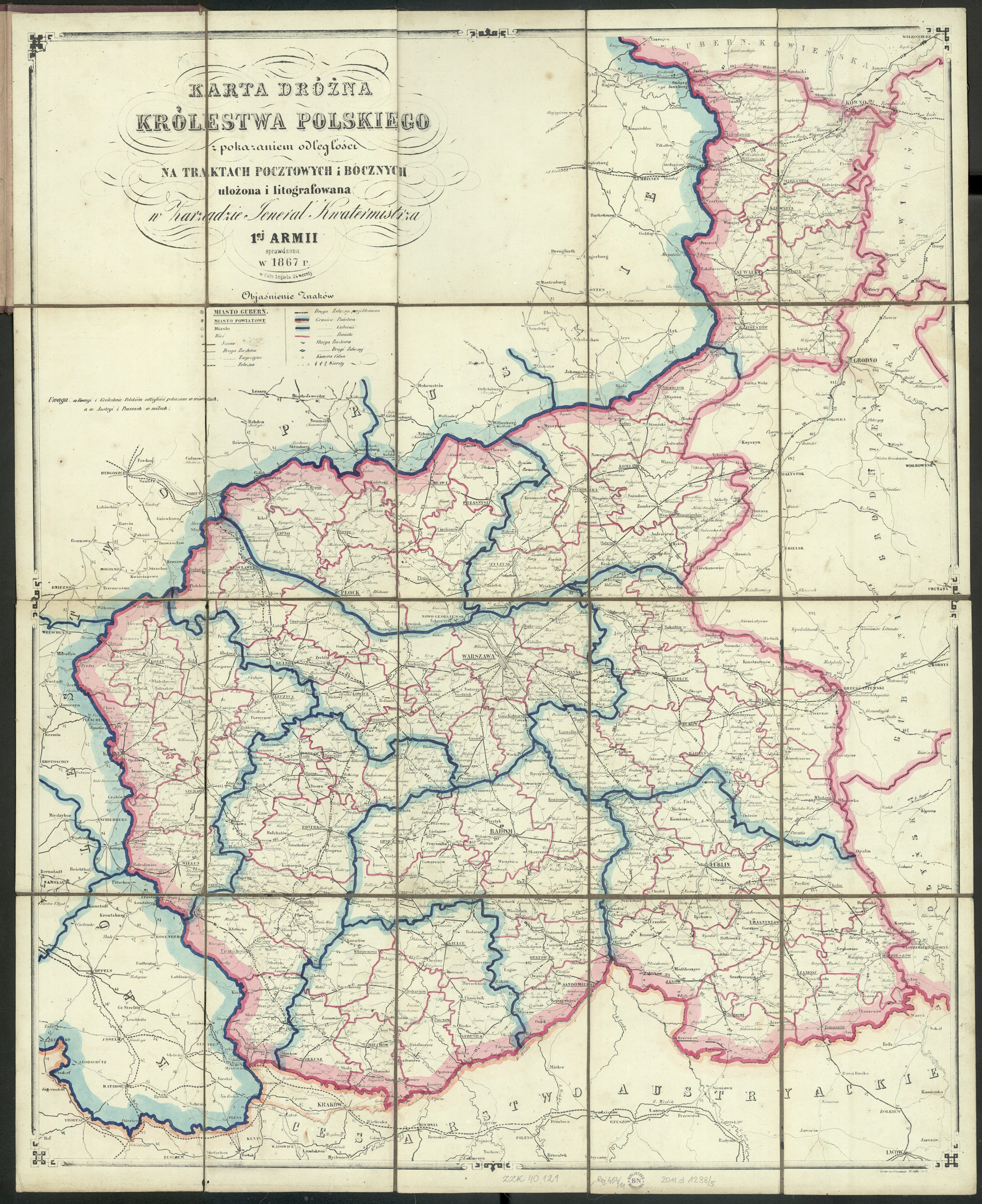
Congress Kingdom of Poland – 1866-1879
Author unknown, Karta Drózna Królestwa Polskiego (Zarządzie General Kwatermistrza 1ej Armii, Place unknown, 1867); digital images, Polona Digital Library (http://polona.pl/item/29081074/ : accessed 09 February 2019).
NOTE: In a proclamation dated 07 September 1870, the city of Warsaw was specifically excluded from the Warsaw Gubernia, subordinate to the General-Governor of Warsaw and the Ministry of Internal Affairs in St. Petersburg.
11 March 1879
In 1879, the Górny Kalwarija Powiat was abolished and its territory was incorporated into the Grójec Powiat. From 11 March 1879 until 17 Oct 1915, the administrative division of the Congress Kingdom of Poland was as follows:
- Kalisz Gubernia (Powiats: Kalisz, Koło, Konin, Łęczyca, Sieradz, Słupca, Turek, and Wieluń)
- Kielce Gubernia (Powiats: Jędrzejów, Kielce, Miechów, Olkusz, Pińczów, Stopnica, and Włoszczowa)
- Lublin Gubernia (Powiats: Biłgoraj, Chełm, Hrubieszów, Janów Lubelski, Krasnystaw, Lubartów, Lublin, Puławy [Nowa Aleksandria], Tomaszów Lubelski, Zamość)
- Łomża Gubernia (Powiats: Kolno, Łomża, Maków Mazowiecki, Ostrołęka, Ostrów Mazowiecka, Pułtusk, Szczuczyn, and Wysokie Mazowieckie)
- Piotrków Gubernia (Powiats: Będziń, Brzeziny, Częstochowa, Łask, Łódź, Piotrków Trybunalski, Radomsko, and Rawa Mazowiecka)
- Płock Gubernia (Powiats: Ciechanów, Lipno, Mława, Płock, Płońsk, Przasnysz, Rypin, and Sierpc)
- Radom Gubernia (Powiats: Iłża, Końskie, Kozienice, Opatów, Opoczno, Radom, and Sandomierz)
- Siedlce Gubernia (Powiats: Biała Podlaska, Garwolin, Konstantynów, Łuków, Radzyń, Podlaski, Siedlce, Sokołów Podlaski, Węgrów, and Włodawa)
- Suwalki Gubernia (Powiats: Augustów, Kalwarija, Kudirkos Naumiestis [Władysławów], Marijampolė, Sejny, Suwałki, and Vilkaviškis)
- Warsaw Gubernia (Powiats: Błonie, Gostyń, Grójec, Kutno, Łowicz, Mińsk Mazowiecki, Radzieje / later Nieszawa, Radzymin, Skierniewice, Sochaczew, Warsaw, and Włocławek)
26 December 1893
In 1893, the Płońsk Powiat (Płock Gubernia) and the Pułtusk Powiat (Łomża Gubernia) were transferred to the Warsaw Gubernia. From 26 December 1893 to 17 Oct 1915, the administrative division of the Congress Kingdom of Poland was as follows:
- Kalisz Gubernia (Powiats: Kalisz, Koło, Konin, Łęczyca, Sieradz, Słupca, Turek, and Wieluń)
- Kielce Gubernia (Powiats: Jędrzejów, Kielce, Miechów, Olkusz, Pińczów, Stopnica, and Włoszczowa)
- Lublin Gubernia (Powiats: Biłgoraj, Chełm, Hrubieszów, Janów Lubelski, Krasnystaw, Lubartów, Lublin, Puławy [Nowa Aleksandria], Tomaszów Lubelski, Zamość)
- Łomża Gubernia (Powiats: Kolno, Łomża, Maków Mazowiecki, Ostrołęka, Ostrów Mazowiecka, Szczuczyn, and Wysokie Mazowieckie)
- Piotrków Gubernia (Powiats: Będziń, Brzeziny, Częstochowa, Łask, Łódź, Piotrków Trybunalski, Radomsko, and Rawa Mazowiecka)
- Płock Gubernia (Powiats: Ciechanów, Lipno, Mława, Płock, Przasnysz, Rypin, and Sierpc)
- Radom Gubernia (Powiats: Iłża, Końskie, Kozienice, Opatów, Opoczno, Radom, and Sandomierz)
- Siedlce Gubernia (Powiats: Biała Podlaska, Garwolin, Konstantynów, Łuków, Radzyń, Podlaski, Siedlce, Sokołów Podlaski, Węgrów, and Włodawa)
- Suwalki Gubernia (Powiats: Augustów, Kalwarija, Kudirkos Naumiestis [Władysławów], Marijampolė, Sejny, Suwałki, and Vilkaviškis)
- Warsaw Gubernia (Powiats: Błonie, Gostyń, Grójec, Kutno, Łowicz, Mińsk Mazowiecki, Nieszawa [formerly Radzieje], Płońsk, Pułtusk, Radzymin, Skierniewice, Sochaczew, Warsaw, and Włocławek)
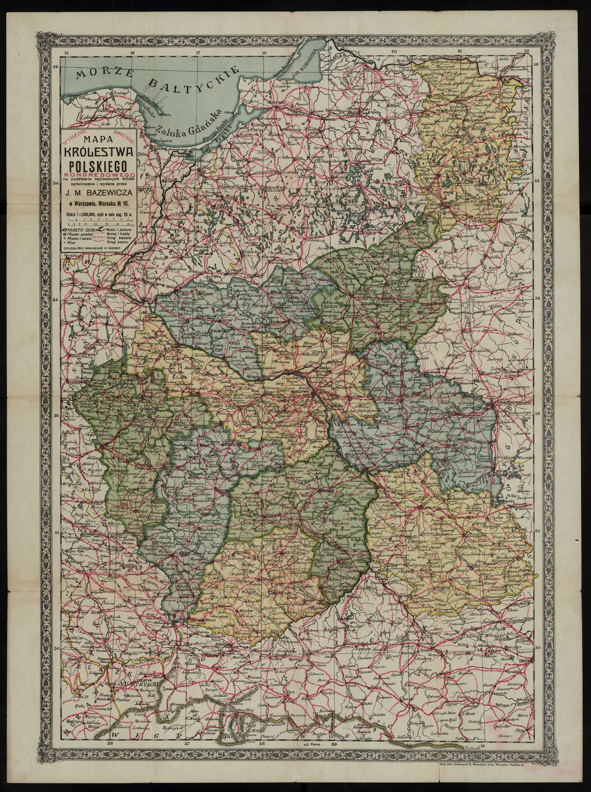
Congress Kingdom of Poland – 1893-1912
Józef Michał Bazewicz, Mapa Królestwa Polskiego Kongresowego : na podstawie najnowszych źródeł (J. M. Bazewicz, Warsaw, about 1914); digital images, Polona Digital Library (http://polona.pl/item/9989656/ : accessed 10 February 2019).
06 July 1912
On 06 July 1912, parts of the Siedlce Gubernia (the Biała Podlaska Powiat, and parts of the Konstantynów, Radzyń, and Włodawa Powiats), and the Lublin Gubernia (the Tomaszów and Hrubiezów Powiats and parts of the Lubartów, Chełm, Krasnystaw, and Biłgoraj Powiats) were split off and combined to form the new Chełm Gubernia. The Węgrów Powiat of the former Siedlce Gubernia was incorporated into the Łomża Gubernia. The remaining territory of the former Siedlce Gubernia was incorporated into the Lublin Gubernia. These changes eliminated the Siedlce Gubernia and resulted in the administrative divisions of the Congress Kingdom of Poland as follows:
- Chełm Gubernia (Powiats: Biłgoraj, Biała Podlaska, Hrubieszów, Chełm, Konstantynów, Tomaszów, Włodawa, and Zamość)
- Kalisz Gubernia (Powiats: Kalisz, Koło, Konin, Łęczyca, Sieradz, Słupca, Turek, and Wieluń)
- Kielce Gubernia (Powiats: Jędrzejów, Kielce, Miechów, Olkusz, Pińczów, Stopnica, and Włoszczowa)
- Lublin Gubernia (Powiats: Garwolin, Janów, Krasnystaw, Lubartów, Lublin, Łuków, Puławy [Nowo-Aleksandria], Radzyń, Siedlce, and Sokołów Podlaski)
- Łomża Gubernia (Powiats: Kolno, Łomża, Maków Mazowiecki, Ostrołęka, Ostrów Mazowiecka, Szczuczyn, Węgrów, and Wysokie Mazowieckie)
- Piotrków Gubernia (Powiats: Będziń, Brzeziny, Częstochowa, Łask, Łódź, Piotrków Trybunalski, Radomsko, and Rawa Mazowiecka)
- Płock Gubernia (Powiats: Ciechanów, Lipno, Mława, Płock, Przasnysz, Rypin, and Sierpc)
- Radom Gubernia (Powiats: Iłża, Końskie, Kozienice, Opatów, Opoczno, Radom, and Sandomierz)
- Suwalki Gubernia (Powiats: Augustów, Kalwarija, Kudirkos Naumiestis [Władysławów], Marijampolė, Sejny, Suwałki, and Vilkaviškis)
- Warsaw Gubernia (Powiats: Błonie, Gostyń, Grójec, Kutno, Łowicz, Mińsk Mazowiecki, Nieszawa [formerly Radzieje], Płońsk, Pułtusk, Radzymin, Skierniewice, Sochaczew, Warsaw, and Włocławek)
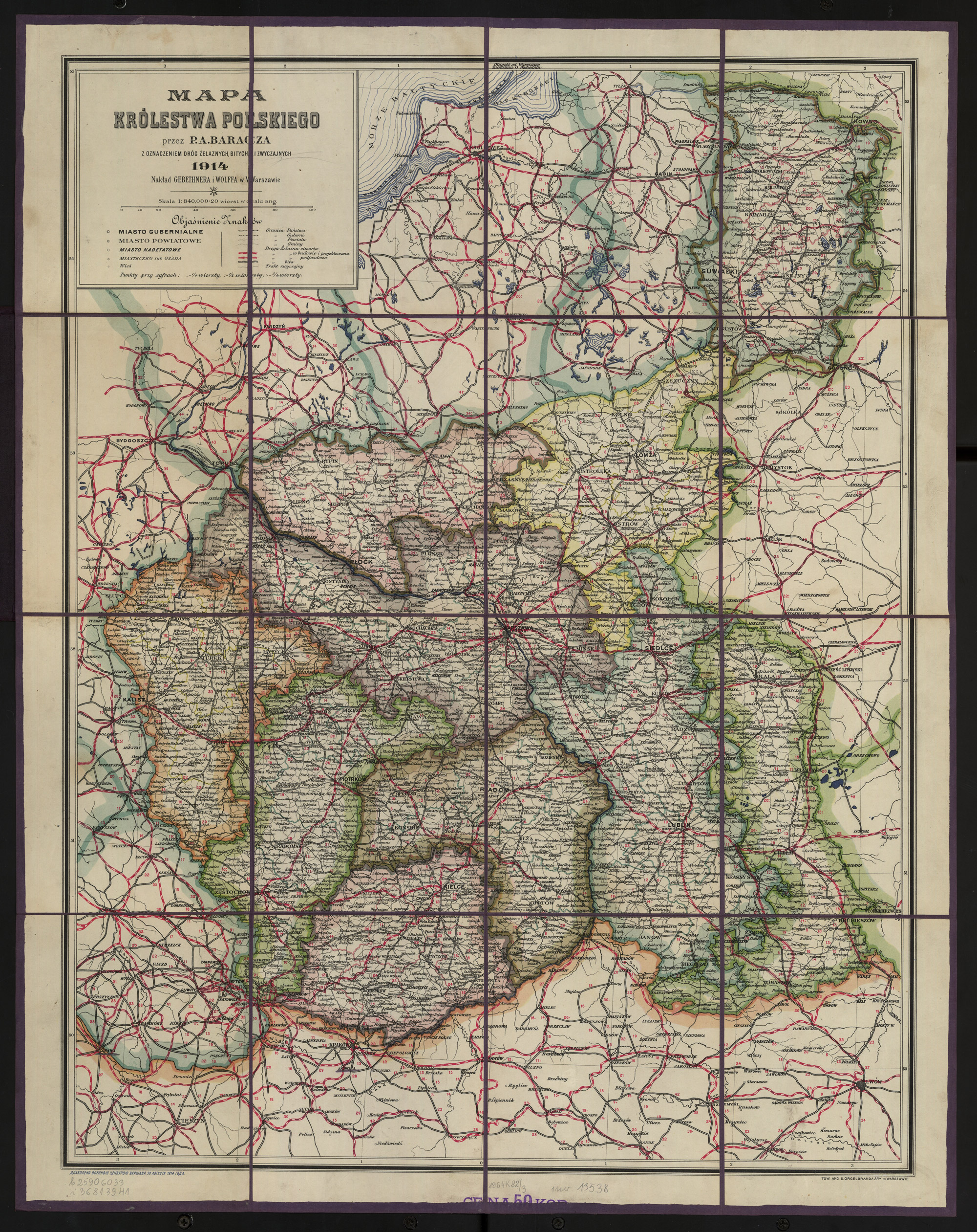
Congress Kingdom of Poland – 1912-1915
P. A. Baracz, Mapa Królestwa Polskiego : z oznaczeniem dróg żelaznych, bitych, i zwyczajnych (Gebethner and Wolff, Warsaw, 1914); digital images, Polona Digital Library (http://polona.pl/item/4901903/ : accessed 10 February 2019).
30 March 1915
On 30 March 1915, the Chełm Gubernia was annexed to the Southwest Krai of the Russian Empire and included the following administrative divisions:
- Chełm Gubernia (Uyezds: Belgoraisky, Belsky, Grubeshovsky, Kholmsk, Konstantinovsky, Tomashevsky, Vlodavsky, and Zamosty)
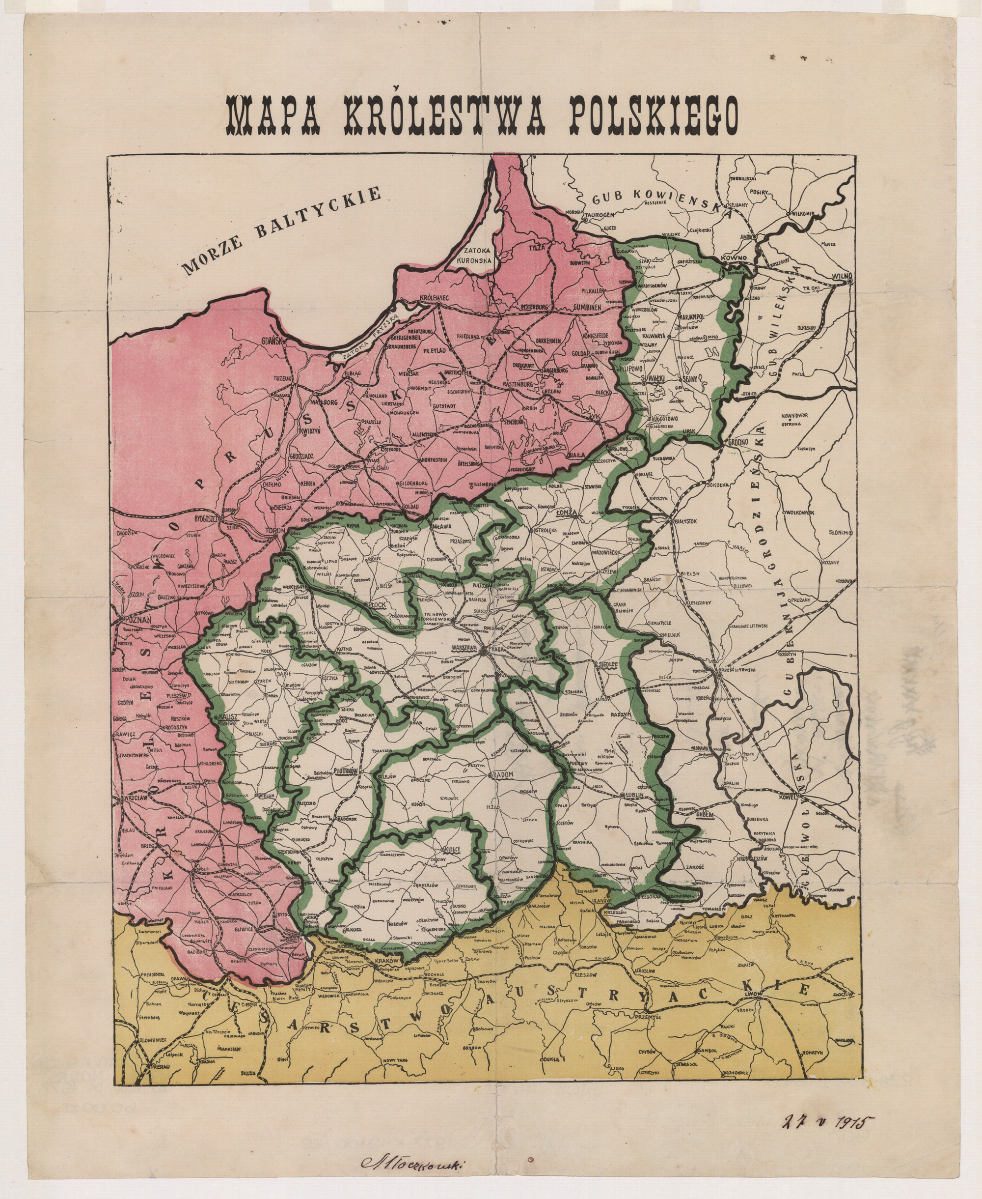
Congress Kingdom of Poland – 1915
Author unknown, Mapa Królestwa Polskiego (Publisher unknown, Place unknown, not before 1915); digital images, Polona Digital Library (http://polona.pl/item/7957782/ : accessed 10 February 2019).
During World War I, the Central Powers divided the territory of the Kingdom of Poland into two zones: German and Austrian. On 01 September 1915, the General Government of Lublin was created from those territories occupied by Austria. The divisions of Gubernias were eliminated from both General Governments. The largest administrative divisions that remained were the Powiats.
01 Septmber 1915
- General Government of Lublin: the former Radom Gubernia, Kielce Gubernia, almost all of the Lublin Gubernia from before 1912, and part of the Piotrków Gubernia
08 September 1915
On 08 September 1915, the General Government of Warsaw was created from those territories occupied by the German Empire.
- General Government of Warsaw: the former Suwalki, Łomża, Płock, Siedlce, and Warsaw Gubernias, almost all of the Kalisz Gubernia (without the Wieluń Powiat), part of the Piotrków Gubernia (all or part of the Brzeziny, Rawa, Łódź, Łasdk, Częstochowa, and Będzin Powiats), and the one powiat from the Lublin Gubernia (Puławy)
- Powiats Włodaw, Radzyn, Bialsk, and Konstantynów were not included in the General Government of Warsaw so that they could be offered to a potential pro-German Ukrainian State
- Suwalki Gubernia was not included in the General Government of Warsaw so that it could be included in the Lithuanian State which was politically connected to the German Reich
Gubernias were abolished and several powiats were combined to form 30 powiats in the General Government of Warsaw, numbered in alphabetical order:
- Będzin
- Błonie
- Częstochowa
- Garwolin
- Grójec
- Kalisz
- Koło
- Konin
- Kutno
- Lipno
- Łęczyca
- Łódż
- Łomża
- Łowicz
- Łuków
- Mińsk Mazowiecki
- Mława
- Ostrołęka
- Ostrów
- Płock
- Pułtusk
- Rawa
- Siedlce
- Sieradz
- Skierniewice
- Sokołów
- Szczuczyn
- Warszawa
- Wieluń
- Włocławek
15 June 1916
- General Government of Lublin: the former Chełm, Hrubieszów, and Tomaszów Powiats were incorporated into the General Government of Lublin
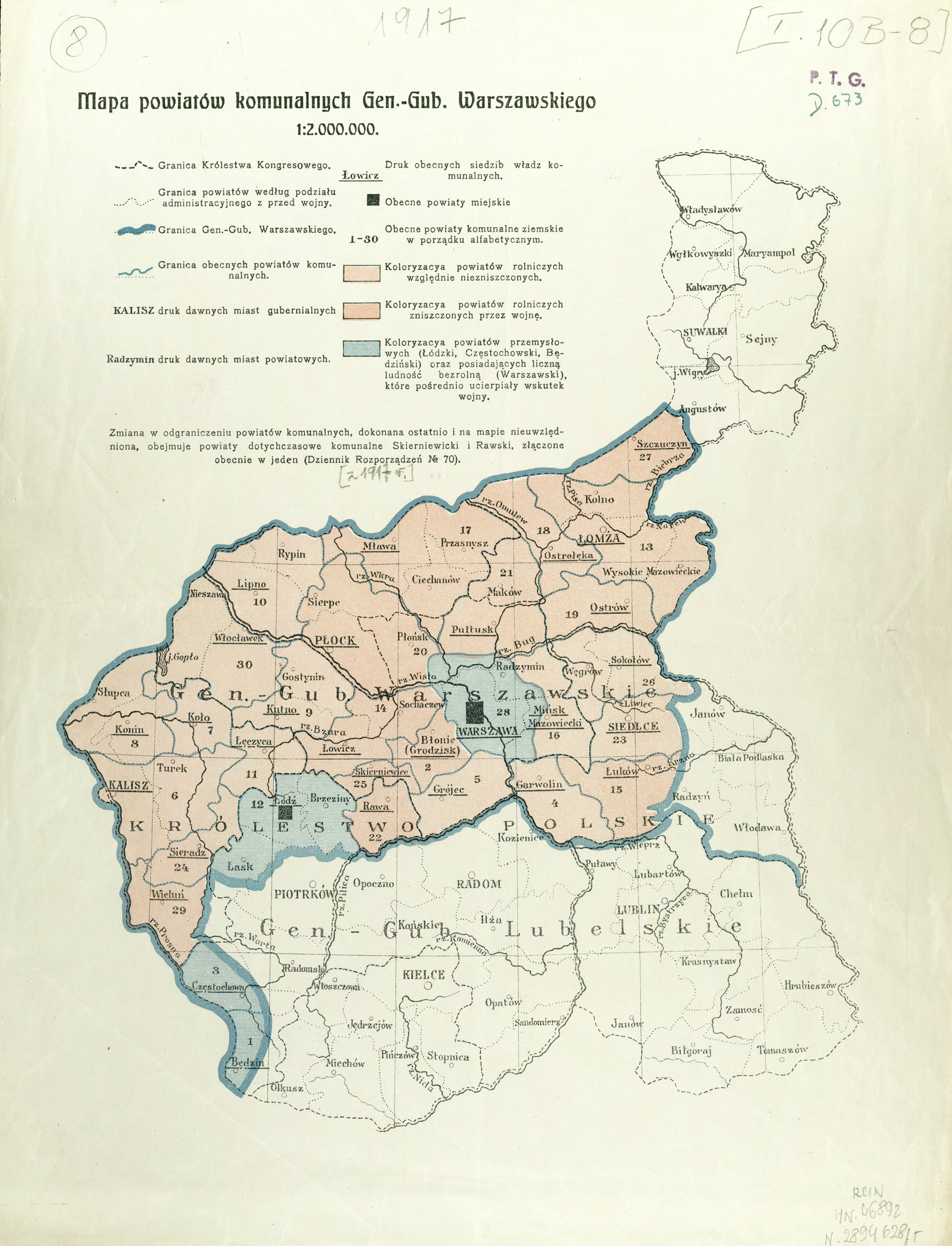
General Governments of Warsaw and Lublin – 1915-1918
Author unknown, Mapa powiatów komunalnych Gen.-Gub. Warszawskiego (Publisher unknown, Place unknown, between 1915-1918); digital images, Digital Repository of Scientific Institutes (http://rcin.org.pl/publication/52547 : accessed 10 February 2019).
REFERENCES:
- Trzebiński, Wojciech, and Adam Borkiewicz. 1956. Podziały administracyjne Królestwa Polskiego w okresie 1815-1918 r.: (zarys historyczny). Warszawa: Polska Akademia Nauk. Instytut Geografii. Image copy. Digital Repository of Scientific Institutes (http://rcin.org.pl/publication/50581 : 2019).
- Borkiewicz, Adam Józzef. 1956. Podziały administracyjne Królestwa Polskiego w okresie 1815-1918 r.: mapy. Warszawa: Polska Akademia Nauk. Instytut Geografii. Image copy. Digital Repository of Scientific Institutes (http://rcin.org.pl/publication/50583 : 2019).
Copyright © 2019 by Stephen J. Danko


Stephen … OUTSTANDING work!
Thanks!
I had never seen a map of how the Kingdom was divided during WW1,
Thank you!