Administrative Structure of the Dubiecko Parish

The villages belonging to either the Roman Catholic or Greek Catholic parish in Dubiecko and named in the Gemeindelexikon der im Reichsrate Vertetenen Konigreiche und Lander XII Galizien (1907) are: Bachórzec, Drohobyczka (including Huta), Dubiecko, Hucisko Nienadowskie, Nienadowa (including Nienadowa Górna), Polchowa (including Podbukowina and Slonne), Przedmieście Dubieckie, Ruska Wieś, and Śliwnica.

Dubiecko Parish - 1910

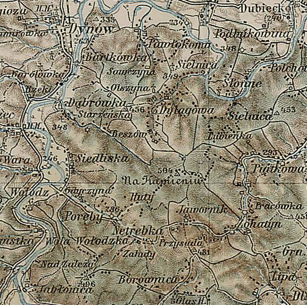
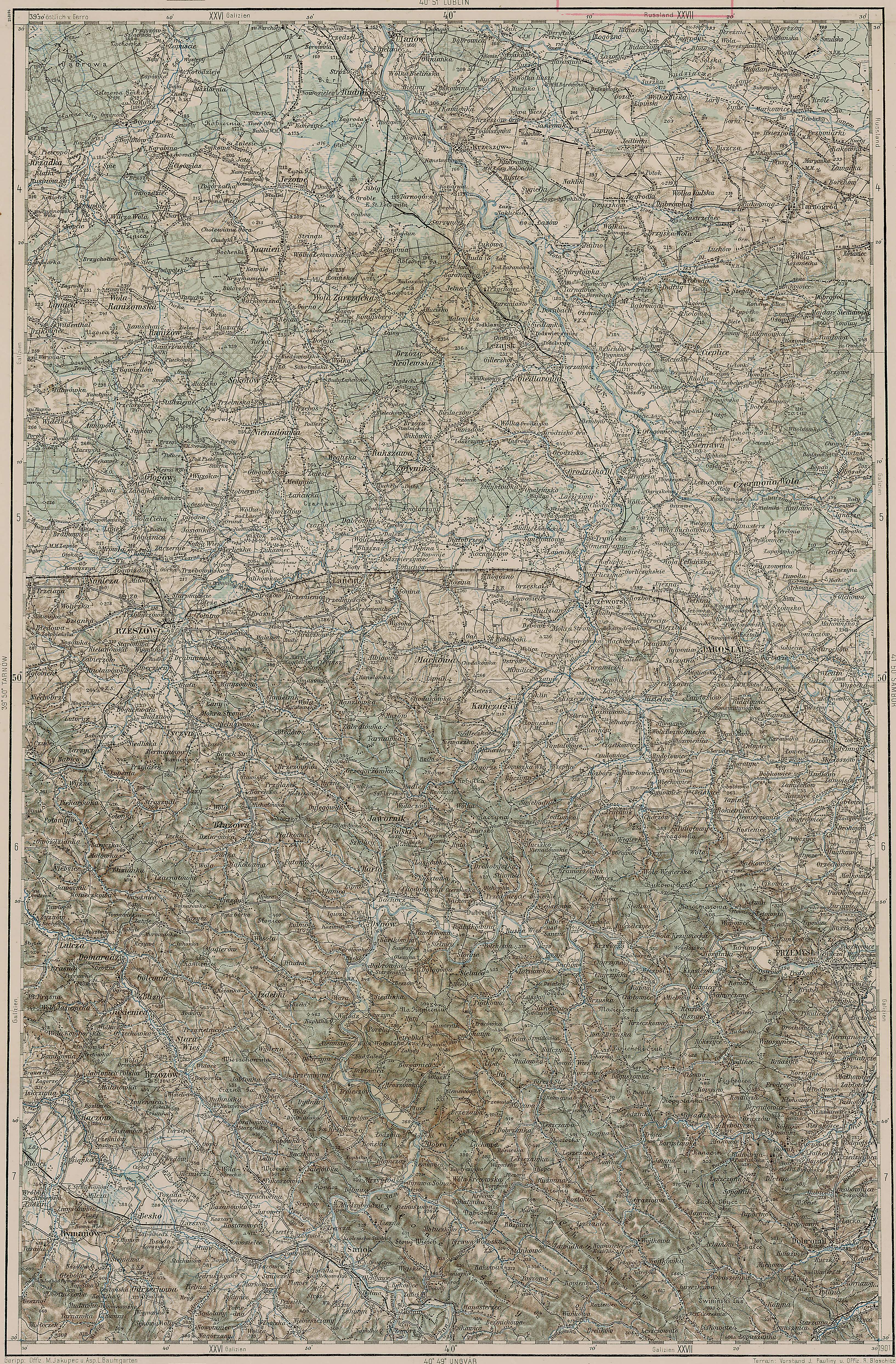
Dubiecko Parish – 1910
Third Military Mapping Survey of Austria-Hungary (ELTE Faculty of Informatics,
Institute of Cartography and Geoinformatics); digital images, Lazarus ELTE
(http://lazarus.elte.hu/hun/digkonyv/topo/200e/40-50.jpg: accessed 21 November 2025)

The administrative structure to which Hucisko Nienadowskie and Nienadowa belonged evolved as follows:

  • 01 Jul 1569-22 Sep 1772: Village, Sanok Powiat, Sanok Ziemia, Ruthenian Voivodeship, Polish-Lithuanian Commonwealth
  • 22 Sep 1772- Nov 1773: Village, Kingdom of Galicia and Lodomeria, Habsburg Monarchy
  • Nov 1773-Nov 1777: Village, Kreis Red Ruthenia, Kingdom of Galicia and Lodomeria, Habsburg Monarchy
  • Nov 1777-21 Mar 1782: Village, Kreisdistrikt Przemyśl, Kreis Sambor, Kingdom of Galicia and Lodomeria, Habsburg Monarchy
  • 22 Mar 1782-11 Aug 1804: Village, Kreis Przemyśl, Kingdom of Galicia and Lodomeria, Habsburg Monarchy
  • 11 Aug 1804-Mar 1854: Village, Kreis Przemyśl, Kingdom of Galicia and Lodomeria, Austrian Empire
  • Apr 1854-28 Mar 1867: Village, Kreis Przemyśl, Lemberg Administrative Area, Kingdom of Galicia and Lodomeria, Austrian Empire
  • 30 Mar 1867-10 Nov 1918: Village, Bezirk Przemyśl, Kingdom of Galicia and Lodomeria, Austria-Hungary
  • 11 Nov 1918-20 Oct 1939: Village, Przemyśl Powiat, Lwów Voivodeship, Second Polish Republic
  • 21 Oct 1939-31 Aug 1941: Village, Ukrainian SSR, Union of Soviet Socialist Republics
  • 01 Sep 1941-27 Jun 1945: Village, District of Kraków, General Government, Nazi Germany
  • 28 Jun 1945-21 Jul 1952: Village, Przemyśl Powiat, Rzeszów Voivodeship, Republic of Poland
  • 22 Jul 1952-31 May 1975: Village, Przemyśl Powiat, Rzeszów Voivodeship, Polish People’s Republic
  • 01 Jun 1975-30 Dec 1989: Village, Przemyśl Voivodeship, Polish People’s Republic
  • 31 Dec 1989-30 Dec 1998: Village, Przemyśl Voivodeship, Third Polish Republic
  • 31 Dec 1998-Present: Village, Przemyśl Powiat, Subcarpathian Voivodeship, Third Polish Republic

The administrative structure to which Bachórzec, Drohobyczka, Dubiecko, Polchowa, Przedmieście Dubieckie, Ruska Wieś, and Śliwnica belonged evolved as follows:

  • 01 Jul 1569-22 Sep 1772: Village, Sanok Powiat, Sanok Ziemia, Ruthenian Voivodeship, Polish-Lithuanian Commonwealth
  • 22 Sep 1772- Nov 1773: Village, Kingdom of Galicia and Lodomeria, Habsburg Monarchy
  • Nov 1773-Nov 1777: Village, Kreis Red Ruthenia, Kingdom of Galicia and Lodomeria, Habsburg Monarchy
  • Nov 1777-21 Mar 1782: Village, Kreisdistrikt Przemyśl, Kreis Sambor, Kingdom of Galicia and Lodomeria, Habsburg Monarchy
  • 22 Mar 1782-11 Aug 1804: Village, Kreis Sanok, Kingdom of Galicia and Lodomeria, Habsburg Monarchy
  • 11 Aug 1804-Mar 1854: Village, Kreis Sanok, Kingdom of Galicia and Lodomeria, Austrian Empire
  • Apr 1854-28 Mar 1867: Village, Kreis Sanok, Lemberg Administrative Area, Kingdom of Galicia and Lodomeria, Austrian Empire
  • 30 Mar 1867-10 Nov 1918: Village, Bezirk Przemyśl, Kingdom of Galicia and Lodomeria, Austria-Hungary
  • 11 Nov 1918-20 Oct 1939: Village, Przemyśl Powiat, Lwów Voivodeship, Second Polish Republic
  • 21 Oct 1939-31 Aug 1941: Village, Ukrainian SSR, Union of Soviet Socialist Republics
  • 01 Sep 1941-27 Jun 1945: Village, District of Kraków, General Government, Nazi Germany
  • 28 Jun 1945-21 Jul 1952: Village, Przemyśl Powiat, Rzeszów Voivodeship, Republic of Poland
  • 22 Jul 1952-31 May 1975: Village, Przemyśl Powiat, Rzeszów Voivodeship, Polish People’s Republic
  • 01 Jun 1975-30 Dec 1989: Village, Przemyśl Voivodeship, Polish People’s Republic
  • 31 Dec 1989-30 Dec 1998: Village, Przemyśl Voivodeship, Third Polish Republic
  • 31 Dec 1998-Present: Village, Przemyśl Powiat, Subcarpathian Voivodeship, Third Polish Republic

Note: According to the Słownik Geograficzny Królewstwa Polskiego (Volume II, published in 1881), the Roman Catholic parish of Dubiecko served the villages of Drobobyczka, Hucisko Nienadowskie, Huta Drohobycka, Nienadowa, Polchowa and Słonne, Przedmieście, and Ruska Wieś; and the Greek Catholic parish of Dubiecko served the villages of Bachorzec, Drohobyczka, Hucisko, Nienadowa, Przedmieście, and Śliwnica.

Copyright © 2025 by Stephen J. Danko

Posted in Daily Journal | Comments Off on Administrative Structure of the Dubiecko Parish

Administrative Structure of the Dudyńce Parish

According to the Słownik Geograficzny Królewstwa Polskiego (Volume 2, published in 1881), the parish of Dudyńce served the villages of Dudyńce, Markowce with Podgaj, Pisarowce, and Pobiedno. According to Wikipedia, the parish of All Saints in Dudyńce once included the villages of Dudyńce, Jędruszkowce, Markowce, Podgaj, Pisarowce, and Pobiedno.

Dudyńce Parish - 1910

Dudyńce Parish – 1910
Third Military Mapping Survey of Austria-Hungary (ELTE Faculty of Informatics,
Institute of Cartography and Geoinformatics); digital images, Lazarus ELTE
(http://lazarus.elte.hu/hun/digkonyv/topo/200e/40-50.jpg: accessed 21 November 2025)

The administrative structure to which Dudyńce, Jędruszkowce, Markowce, Podgaj, Pisarowce, and Pobiedno belonged evolved as follows:

  • 01 Jul 1569-22 Sep 1772: Village, Sanok Powiat, Sanok Ziemia, Ruthenian Voivodeship, Polish-Lithuanian Commonwealth
  • 22 Sep 1772- Nov 1773: Village, Kingdom of Galicia and Lodomeria, Habsburg Monarchy
  • Nov 1773-Nov 1777: Village, Kreis Red Ruthenia, Kingdom of Galicia and Lodomeria, Habsburg Monarchy
  • Nov 1777-21 Mar 1782: Village, Kreisdistrikt Lisko, Kreis Sambor, Kingdom of Galicia and Lodomeria, Habsburg Monarchy
  • 22 Mar 1782-11 Aug 1804: Village, Kreis Sanok, Kingdom of Galicia and Lodomeria, Habsburg Monarchy
  • 11 Aug 1804-Mar 1854: Village, Kreis Sanok, Kingdom of Galicia and Lodomeria, Austrian Empire
  • Apr 1854-28 Mar 1867: Village, Kreis Sanok, Lemberg Administrative Area, Kingdom of Galicia and Lodomeria, Austrian Empire
  • 30 Mar 1867-10 Nov 1918: Village, Bezirk Sanok, Kingdom of Galicia and Lodomeria, Austria-Hungary
  • 11 Nov 1918-20 Oct 1939: Village, Sanok Powiat, Lwów Voivodeship, Second Polish Republic
  • 21 Oct 1939-31 Aug 1941: Village, Ukrainian SSR, Union of Soviet Socialist Republics
  • 01 Sep 1941-27 Jun 1945: Village, District of Kraków, General Government, Nazi Germany
  • 28 Jun 1945-21 Jul 1952: Village, Sanok Powiat, Rzeszów Voivodeship, Republic of Poland
  • 22 Jul 1952-31 May 1975: Village, Sanok Powiat, Rzeszów Voivodeship, Polish People’s Republic
  • 01 Jun 1975-30 Dec 1989: Village, Krosno Voivodeship, Polish People’s Republic
  • 31 Dec 1989-30 Dec 1998: Village, Krosno Voivodeship, Third Polish Republic
  • 31 Dec 1998-Present: Village, Sanok Powiat, Subcarpathian Voivodeship, Third Polish Republic

Copyright © 2025 by Stephen J. Danko

Posted in Daily Journal | Comments Off on Administrative Structure of the Dudyńce Parish

Administrative Structure of the Dylągowa Parish

According to the Słownik Geograficzny Królewstwa Polskiego (Volume 2, published in 1881), the parish of Dylągowa served the villages of Borownica (part of Jawornik Ruski until World War II), Dąbrówka Starzeńska, Dylągowa, Huta Poręby, Jasionów (part of Huta Poręby), Jawornik Ruski, Pawłokoma, Pracówka (part of Żohatyn), Siedliska, Sielnica, Wołodż, and Żohatyn.

Dylągowa Parish - 1910

Dylągowa Parish – 1910
Third Military Mapping Survey of Austria-Hungary (ELTE Faculty of Informatics,
Institute of Cartography and Geoinformatics); digital images, Lazarus ELTE
(http://lazarus.elte.hu/hun/digkonyv/topo/200e/40-50.jpg: accessed 02 October 2025)

The administrative structure to which Dąbrówka Starzeńska, Dylągowa, and Pawłokoma belonged evolved as follows:

  • 01 Jul 1569-22 Sep 1772: Village, Sanok Powiat, Sanok Ziemia, Ruthenian Voivodeship, Polish-Lithuanian Commonwealth
  • 22 Sep 1772- Nov 1773: Village, Kingdom of Galicia and Lodomeria, Habsburg Monarchy
  • Nov 1773-Nov 1777: Village, Kreis Red Ruthenia, Kingdom of Galicia and Lodomeria, Habsburg Monarchy
  • Nov 1777-21 Mar 1782: Village, Kreisdistrikt Przemyśl, Kreis Sambor, Kingdom of Galicia and Lodomeria, Habsburg Monarchy
  • 22 Mar 1782-11 Aug 1804: Village, Kreis Sanok, Kingdom of Galicia and Lodomeria, Habsburg Monarchy
  • 11 Aug 1804-Mar 1854: Village, Kreis Sanok, Kingdom of Galicia and Lodomeria, Austrian Empire
  • Apr 1854-28 Mar 1867: Village, Kreis Sanok, Lemberg Administrative Area, Kingdom of Galicia and Lodomeria, Austrian Empire
  • 30 Mar 1867-10 Nov 1918: Village, Bezirk Brzozów, Kingdom of Galicia and Lodomeria, Austria-Hungary
  • 11 Nov 1918-20 Oct 1939: Village, Brzozów Powiat, Lwów Voivodeship, Second Polish Republic
  • 21 Oct 1939-31 Aug 1941: Village, Ukrainian SSR, Union of Soviet Socialist Republics
  • 01 Sep 1941-27 Jun 1945: Village, District of Kraków, General Government, Nazi Germany
  • 28 Jun 1945-21 Jul 1952: Village, Brzozów Powiat, Rzeszów Voivodeship, Republic of Poland
  • 22 Jul 1952-31 May 1975: Village, Brzozów Powiat, Rzeszów Voivodeship, Polish People’s Republic
  • 01 Jun 1975-30 Dec 1989: Village, Przemyśl Voivodeship, Polish People’s Republic
  • 31 Dec 1989-30 Dec 1998: Village, Przemyśl Voivodeship, Third Polish Republic
  • 31 Dec 1998-Present: Village, Rzeszów Powiat, Subcarpathian Voivodeship, Third Polish Republic

The administrative structure to which Sielnica belonged evolved as follows:

  • 01 Jul 1569-22 Sep 1772: Village, Sanok Powiat, Sanok Ziemia, Ruthenian Voivodeship, Polish-Lithuanian Commonwealth
  • 22 Sep 1772- Nov 1773: Village, Kingdom of Galicia and Lodomeria, Habsburg Monarchy
  • Nov 1773-Nov 1777: Village, Kreis Red Ruthenia, Kingdom of Galicia and Lodomeria, Habsburg Monarchy
  • Nov 1777-21 Mar 1782: Village, Kreisdistrikt Przemyśl, Kreis Sambor, Kingdom of Galicia and Lodomeria, Habsburg Monarchy
  • 22 Mar 1782-11 Aug 1804: Village, Kreis Sanok, Kingdom of Galicia and Lodomeria, Habsburg Monarchy
  • 11 Aug 1804-Mar 1854: Village, Kreis Sanok, Kingdom of Galicia and Lodomeria, Austrian Empire
  • Apr 1854-28 Mar 1867: Village, Kreis Sanok, Lemberg Administrative Area, Kingdom of Galicia and Lodomeria, Austrian Empire
  • 30 Mar 1867-10 Nov 1918: Village, Bezirk Przemyśl, Kingdom of Galicia and Lodomeria, Austria-Hungary
  • 11 Nov 1918-20 Oct 1939: Village, Przemyśl Powiat, Lwów Voivodeship, Second Polish Republic
  • 21 Oct 1939-31 Aug 1941: Village, Ukrainian SSR, Union of Soviet Socialist Republics
  • 01 Sep 1941-27 Jun 1945: Village, District of Kraków, General Government, Nazi Germany
  • 28 Jun 1945-21 Jul 1952: Village, Przemyśl Powiat, Rzeszów Voivodeship, Republic of Poland
  • 22 Jul 1952-31 May 1975: Village, Przemyśl Powiat, Rzeszów Voivodeship, Polish People’s Republic
  • 01 Jun 1975-30 Dec 1989: Village, Przemyśl Voivodeship, Polish People’s Republic
  • 31 Dec 1989-30 Dec 1998: Village, Przemyśl Voivodeship, Third Polish Republic
  • 31 Dec 1998-Present: Village, Przemyśl Powiat, Subcarpathian Voivodeship, Third Polish Republic

The administrative structure to which Borownica, Jawornik Ruski, Pracówka (part of Żohatyn), and Żohatyn belonged evolved as follows:

  • 01 Jul 1569-22 Sep 1772: Village, Sanok Powiat, Sanok Ziemia, Ruthenian Voivodeship, Polish-Lithuanian Commonwealth
  • 22 Sep 1772- Nov 1773: Village, Kingdom of Galicia and Lodomeria, Habsburg Monarchy
  • Nov 1773-Nov 1777: Village, Kreis Red Ruthenia, Kingdom of Galicia and Lodomeria, Habsburg Monarchy
  • Nov 1777-21 Mar 1782: Village, Kreisdistrikt Przemyśl, Kreis Sambor, Kingdom of Galicia and Lodomeria, Habsburg Monarchy
  • 22 Mar 1782-11 Aug 1804: Village, Kreis Sanok, Kingdom of Galicia and Lodomeria, Habsburg Monarchy
  • 11 Aug 1804-Mar 1854: Village, Kreis Sanok, Kingdom of Galicia and Lodomeria, Austrian Empire
  • Apr 1854-28 Mar 1867: Village, Kreis Sanok, Lemberg Administrative Area, Kingdom of Galicia and Lodomeria, Austrian Empire
  • 30 Mar 1867-29 Sep 1876: Village, Bezirk Bircza, Kingdom of Galicia and Lodomeria, Austria-Hungary
  • 30 Sep 1876-10 Nov 1918: Village, Bezirk Dobromil, Kingdom of Galicia and Lodomeria, Austria-Hungary
  • 11 Nov 1918-20 Oct 1939: Village, Dobromil Powiat, Lwów Voivodeship, Second Polish Republic
  • 21 Oct 1939-31 Aug 1941: Village, Ukrainian SSR, Union of Soviet Socialist Republics
  • 01 Sep 1941-27 Jun 1945: Village, District of Kraków, General Government, Nazi Germany
  • 28 Jun 1945-21 Jul 1952: Village, Przemyśl Powiat, Rzeszów Voivodeship, Republic of Poland
  • 22 Jul 1952-31 May 1975: Village, Przemyśl Powiat, Rzeszów Voivodeship, Polish People’s Republic
  • 01 Jun 1975-30 Dec 1989: Village, Przemyśl Voivodeship, Polish People’s Republic
  • 31 Dec 1989-30 Dec 1998: Village, Przemyśl Voivodeship, Third Polish Republic
  • 31 Dec 1998-Present: Village, Przemyśl Powiat, Subcarpathian Voivodeship, Third Polish Republic

The administrative structure to which Huta Poręby, Jasionów (part of Huta Poręby), Siedliska, and Wołodż belonged evolved as follows:

  • 01 Jul 1569-22 Sep 1772: Village, Sanok Powiat, Sanok Ziemia, Ruthenian Voivodeship, Polish-Lithuanian Commonwealth
  • 22 Sep 1772- Nov 1773: Village, Kingdom of Galicia and Lodomeria, Habsburg Monarchy
  • Nov 1773-Nov 1777: Village, Kreis Red Ruthenia, Kingdom of Galicia and Lodomeria, Habsburg Monarchy
  • Nov 1777-21 Mar 1782: Village, Kreisdistrikt Przemyśl, Kreis Sambor, Kingdom of Galicia and Lodomeria, Habsburg Monarchy
  • 22 Mar 1782-11 Aug 1804: Village, Kreis Sanok, Kingdom of Galicia and Lodomeria, Habsburg Monarchy
  • 11 Aug 1804-Mar 1854: Village, Kreis Sanok, Kingdom of Galicia and Lodomeria, Austrian Empire
  • Apr 1854-28 Mar 1867: Village, Kreis Sanok, Lemberg Administrative Area, Kingdom of Galicia and Lodomeria, Austrian Empire
  • 30 Mar 1867-10 Nov 1918: Village, Bezirk Brzozów, Kingdom of Galicia and Lodomeria, Austria-Hungary
  • 11 Nov 1918-20 Oct 1939: Village, Brzozów Powiat, Lwów Voivodeship, Second Polish Republic
  • 21 Oct 1939-31 Aug 1941: Village, Ukrainian SSR, Union of Soviet Socialist Republics
  • 01 Sep 1941-27 Jun 1945: Village, District of Kraków, General Government, Nazi Germany
  • 28 Jun 1945-21 Jul 1952: Village, Brzozów Powiat, Rzeszów Voivodeship, Republic of Poland
  • 22 Jul 1952-31 May 1975: Village, Brzozów Powiat, Rzeszów Voivodeship, Polish People’s Republic
  • 01 Jun 1975-30 Dec 1989: Village, Krosno Voivodeship, Polish People’s Republic
  • 31 Dec 1989-30 Dec 1998: Village, Krosno Voivodeship, Third Polish Republic
  • 31 Dec 1998-Present: Village, Brzozów Powiat, Subcarpathian Voivodeship, Third Polish Republic

Copyright © 2025 by Stephen J. Danko

Posted in Daily Journal | Comments Off on Administrative Structure of the Dylągowa Parish

Marriage of Jan Staroba and Mariana Husták – 1894

Jan Staroba and Mariana Husták were married on 19 November 1894 in Komňa, Uherský Brod District, Hradišťský Region, Margraviate of Moravia, Austria-Hungary. Today, Komňa is in the Uherské Hradiště District, Zlín Region, Czechia. Note that different parts of this record are written in German, Latin, and Czech!

Marriage Record for Jan Staroba and Marianna Hnstak - 1894 - Part 1
Marriage Record for Jan Staroba and Marianna Hnstak - 1894 - Part 2

Marriage Record for Jan Staroba and Marianna Hustak – 1894

As written in German, Latin, and Czech, the record states:

sv. II. Fol. 146. Trauungs-Matrik für das Jahr 1894. Obec Komna
Tom. et Fol.: sv. II. Fol. 146
Jahr, Monat und Tag der Trauung: 1894 listopad 19.
Name und Charakter des trauenden Priesters: Jan Mikulka, farář
Des Bräutigams
Haus-Nro.: 177
Name, Stand und Filiation: Jan Staroba, stolář a domkař v Komně, syn Jan Staroby, domkaře v Komně, a aeho manželky Františky, dcery Františka Malca, domkaře v komně. (4/9 1869)
Relig.: katholicsch
Ulter: Jahre 25, Monate 2
ledig
Der Braut
Haus-Nro.: 57
Name, Stand und Filiation: Haus-Nro.: 177
Name, Stand und Filiation: Marianna, dcera Josefa Hustáka, čtovtnika v Komné, a jeho manželky Marianny, dcery Antonina Mickulky, čtovtnika v Komné (5/8 1875)
Relig.: katholicsch
Alter: Jahre 25, Monate 2
ledig
Nižepsaný otec nezletilé nevésty sooluje ktomsto manželstoí soým a ě svědkú podpisem:
Joznf Hůsták otec; Tomáš [L. Nalno?], svédek; Ondřej Mlčuch, svédek
Der Beistände:
Name: Tomáš [L. Nalno?]; Ondřej Mlčuch
Stand und Wohnort:

Ohlášeni byli Dom. 25. – Dom. 26. – Dom. 27. post Pent. t. j. 4. – 11. – 18. Listopadu 1894.

Coram me parocho
Joanne Mikulka

In English, the record states:

Volume II. Folio 146. Marriage-Register
Volume and Folio: Volume II. Folio 146
Year, month, and date of the wedding: 19 November 1894
Name and character of the officiating priest: Jan Mikulka, parish priest
The Groom:
House Number: 177
Name, Status and Affiliation: Jan Staroba, carpenter and peasant in Komno, son of Jan Staroba, peasant in Komno, and his wife Františka, daughter of František Malc, peasant in Komno. (4/9 1869)
Religion: Catholic
Age: 25 years, 2 months
Single
The Bride:
House Number: 57
Name, Status and Affiliation: Marianna, daughter of Josef Husták, small landowner in Komná, and his wife Marianna, daughter of Antonin Mickulka, small landowner in Komná (5/8 1875)
Age: 19 years, 3 months
Single
The father of a minor bride named below solemnizes the marriage with his and a witness’s signature.
Josef Hůsták father; Tomáš [L. Nalno?]; witness; Ondřej Mlčuch, witness
The Assistants:
Name: Tomáš [L. Nalno?]; Ondřej Mlčuch
Status and Residence: small landowner in Komná; small landowner in Komná

They [marriage banns] were announced on Sunday 25th – Sunday 26th – Sunday 27th after Pentecost, i.e. November 4th – 11th – 18th, 1894.

Before me, the pastor
Jan Mikulka

Note: This record includes several dates written in after this document was originally created. I have not yet deciphered what all these dates mean.

Copyright © 2025 by Stephen J. Danko

Posted in Daily Journal | Comments Off on Marriage of Jan Staroba and Mariana Husták – 1894

Birth and Baptism of Celestina Staroba – 1897

Celestyna Staroba was born on 02 May 1897 and baptized on 04 Mat 1897 in Komňa, Uherský Brod District, Hradišťský Region, Margraviate of Moravia, Austria-Hungary. Today, Komňa is in the Uherské Hradiště District, Zlín Region, Czechia.

Header for Celestina Staroba Birth/Baptismal Record - 1897
Birth and Baptismal Record for Celestina Staroba - 1897

Birth and Baptismal Record for Celestina Staroba – 1897

In Czech, the record states:

Svaz. III. str. 239 Rodní a křestní kniha. Rok 1897. Obec Komna.
Den měsíc a rok narozeni: 2. květen 1897
Den měsíc a rok pokřtěni: 4. květen 1897
Křtěnce:
Číslo domu: 198
jmeno: Celestina
Náboz.: katol
Pohlaví: ženské
Lože: manželskě
Otce:
jmeno, stav a rod: Staroba Jan, stolar, domkař v Komně, syn Jana Staroby, domkaře o Komně, a jeko manželky Františky, dcery Františka Malce, domkaře v Komně.
nábož.: katol.
Matky:
Jmeno, stav a rod: Mariana, dcera Josepfa Hustáka, čtovtnika v Komně, a jeko manželky Mariany, dcery Antonína Mikulky, čtovtnika v Komně.
Nábož.: katol.
Křtící kněz Bába: Jan Mikulka, farář; Frant. Kudelíková, u Komně čis. 171.
Kmotrův jmeno, stav a bydliště: Ondřej Mlčuch čtovtník u Komně a Františka jeho manželka.

In English, the record states:

Vol. III. p. 239 Birth and baptismal register. Year 1897. Komňa village.
Day, month, and year of birth: 02 May 1897
Day, month, and year of baptism: 04 May 1897
Baptism:
House number: 198
Name: Celestina
Religion: Catholic
Sex: female
Marriage: married
Father:
Name, status and parentage: Jan Staroba, carpenter, peasant in Komňa, son of Jan Staroba, peasant in Komňa, and his wife of Františka, daughter of František Malka, peasant in Komno.
Religion: Catholic
Mother:
Name, status and parentage: Mariana, daughter of Josep Husták, small landowner in Komňa, and as wife of Mariana, daughter of Antonín Mikulka, small landowner in Komňa.
Religion: Catholic
Baptizing Priest / midwife?: Jan Mikulka, parish priest; Františka Kudelíková, at Komňa No. 171.
Godfather’s name, status and residence: Ondřej Mlčuch, small landowner at Komňa, and Františka, his wife.

This is the first time I’ve tried to read a Czech record. I apologize for any errors in the transcription or translation. Links to the digital archives of Czechia may be found at: https://www.myczechroots.com/search-tools/digital-archives.

A list of archaic occupations (such as čtvrtláník and domkář) that appear in Czech registries may be found at: http://czechgenealogy.nase-koreny.cz/2012/12/occupation-dictionary-updated.html.

Copyright © 2025 by Stephen J. Danko

Posted in Daily Journal | Comments Off on Birth and Baptism of Celestina Staroba – 1897

Wails of Sax Makes Ma Leave

I stumbled on this newspaper article and thought it was one of the strangest justifications for divorce I’d ever seen.

Wails of Sax Makes Ma Leave
“Wails of Sax Makes Ma Leave.” The Escanaba Daily Press, 17 January 1930. HTML edition, archived. (https://www.newspapers.com/article/the-escanaba-daily-press-wails-of-sax-ma/174599530/ : accessed 15 June 2025), column 2; citing print edition, p. 1.

Wails Of Sax Makes Ma Leave

Detroit, Jan. 16 (AP)—Four wailing saxophones in the hands and mouths of persons “afflicted with notions that some day they might be musicians” drove Mrs. Augusta Rebitske, 60, from home, she testified in her divorce suit here today.

Judge Guy A. Miller granted her a decree after hearing her story of the musical aspirations of her two step-sons, step-daughter and A step-granddaughter. Among other acts of cruelty on the part of the husband, John Rebitske, was his failure to stop the wails of the four instruments, Mrs. Rebitske said.

Copyright © 2025 by Stephen J. Danko

Posted in Daily Journal | Comments Off on Wails of Sax Makes Ma Leave

Archaic Terms in Polish Metrical Records – Part 4

In previous posts, the meanings of the words zawczoraj and onegdaj were both defined as “the day before yesterday”, the word zaonegdaj was defined as “three days ago”, and the word niewieści was defined as “women”. Another related word is also difficult to find in current dictionaries: pozawczoraj.

The Słownik języka polskiego (Dictionary of the Polish language) describes the word pozawczoraj in this way:

Definition of pozawczoraj

pozawczoraj «the day before yesterday; the day before yesterday, the day before yesterday»: The day before yesterday they were alone together on a walk! KRASZ. Poeta 174. I saw your father the day before yesterday, he was in good health and went back to the country. KRASIŃ. Letters II, 335. The day before yesterday I spent the evening talking. SŁOW. Letters I, 113 // SW

Archaic Terms in Polish Metrical Records – Part 1
Archaic Terms in Polish Metrical Records – Part 2
Archaic Terms in Polish Metrical Records – Part 3

Copyright © 2025 by Stephen J. Danko

Posted in Daily Journal | Comments Off on Archaic Terms in Polish Metrical Records – Part 4

Marriage of Telesfor Wincenty Chodkowski and Paulina Kobylińska – 1888

Telesfor Wincenty Chodkowski married Paulina Kobylińska on 12 January 1888 in Płoniawy.

Telesfor’s name was shown as “Telesfor Wincenty (two names) Chodkowski, a.k.a. Kołakowski, whom Izabel Kolakowska confirmed”. He was 31 years old, born in the village of Las (Szelków parish), son of Remigiusz and Franciszka née Kołakowska Chodkowski.

Paulina Kobylińska was 24 years old, born in the village of Bobino Wielkie (Przasnysz parish), daughter of Teodor and Marianna née Chodkowska Kobyliński.

Marriage of Telesfor Wincenty Chodkowski and Paulina Kobylińska - 1888

Marriage of Telesfor Wincenty Chodkowski and Paulina Kobylińska – 1888

In Russian, this document states:

Бобино Вельке
23.
Состоялосъ въ деревне Плонявахъ, тридцать перваго Январ (двенадцатаго Февраля) Тысяча восемьсотъ восемьдесятъ восмаго года, въ три часа по полудни. Объявляемъ что въ присутствии овидетсгей Юзефа Чаплицкаго сорока летъ, Якуба Политовскаго пятьдесяти летъ отъ роду, обоихъ част бладеьцевъ жительствующихъ въ деревне Бобино-Вельке, заключепо сего числа религиозный брачный союзъ между. Телесфоримъ Викентисиъ двухъ именъ Ходковскимъ, онъ же, Колаковскии которого Изабеля Колаковская уеановлела, а которой актъ уеановления, согеласно закона въ копии предявлнъ къ сепу акту выданъ Администраторимъ Шельковскаго Прихода, отъ восемьнадцатаго (мридцатаго) Января сего года, за  номеромъ пятымъ, тридцати одного года, холостылмъ объездчикоиъ Казеннахъ Лесовъ въ деревне Липа Праснымскаго Уезда, урозенцеле селения Лась Шельковскаго Лрихода, Маковскаго Уезда, сыномъ Ремигиуша и Францишки урожденной Колаковской супруговъ Ходковскихъ, пеиющинъ жительство въ деревне Липа, и паулиного Кобылинского девицею родившеюся въ селении Бобино-Вельке, дочерью Теодора и Мариянна урожденной Ходковской, супруговъ Кобылинскихъ, частныхъ впадельцевъ жительствующихъ въ деревне Бобино-Вельке, двадцати четирехъ летъ, жительствующего при родиинеляхъ, – Браку сему предшествовали три огпашения опубликлованные въ Праснышскииъ Приходскихь Костелахъ въ Воскресныь дни, а лменно, семьнадцатаго, двадцать четвертаго, и тридцать перваго Января (двадцать девятаго Января, пятаго и двенадцатаго Февраля) текущаго года. Новобрачные объявляютъ что опи предбрачнаго договора не заключиен. Религиозный обрядъ бракосочетания совершенъ Ксендзомъ Эдуардоиъ Гуто вскииъ Плонявскииъ Администраторомъ. Актъ сей Новобрачнымъ и свидетелямъ прочитанъ Нами и Новобрачными подписанъ, свидетелям неграмотние. – Кс. Эд. Гитовскии плонявскии Администраторъ Содержащий Акты Граж[данскаго] Сост[ояния]
T. W. Chodkowski vel Kołakowski
P. Kobylińska

Translated into English, the document states:

Bobino Wielkie
23.
This took place in the village of Płoniawy on 31 January [Julian calendar] / 12 February [Gregorian calendar] 1888, at 3 o’clock in the afternoon. We declare that in the presence of Joseph Czaplicki, 40 years old, and Jakub Politowski, 50 years old, both of whose parents live in the village of Bobino Wielkie, a religious marriage union was concluded on this day between Telesfor Wincenty (two names) Chodkowski, a.k.a. Kołakowski, whom Izabela Kolakowska confirmed and a copy of whose act of confirmation issued by the Administrator of Szelków Parish on the 18th [Julian calendar] / 30th [Gregorian calendar] of January of this year, number 5, is attached to this record in accordance with the law, 31 years old, unmarried, the ranger of the State Forests in the village of Lipa, Przasnysz Powiat, born in the village of Łaś, Szelków parish, Maków Powiat, son of the married couple Remigiusz and Franciszka née Kołakowska Chodkowski who resided in the village of Lipa, and Paulina Kobylińska, a maiden born in the village of Bobino-Wielkie, daughter of the married couple Teodor and Marianna née Chodkowska Kobyliński, private owners living in the village of Bobino-Wielkie, 24 years old, living with her parents, – This marriage was preceded by three declarations published in the Przasnysz Parish Church on Sundays, namely, the 17th, 24th, and 31st of January [Julian calendar] / 29 January, 5th and 12th of February [Gregorian calendar] of the current year. The newlyweds declare that no prenuptial agreement has been concluded. The religious ceremony of marriage was performed by Father Edward Gutowski, Administrator of Płoniawy. This document was read to the newlyweds and witnesses by us and signed by the newlyweds. The witnesses are illiterate. – Reverend Ed[ward] Gutowski, Administrator of Płoniawy, Maintaining the Records of the Civil State
[signed] T. W. Chodkowski a.k.a. Kołakowski
[signed] P. Kobylińska

It’s not clear why Telesfor’s name is listed as Telesfor Wincenty Chodkowski a.k.a. Kołakowski, or who Izabela Kołakowski is. What is clear, is that there is some legal connection between Telesfor and Izabela.

Copyright © 2025 by Stephen J. Danko

Posted in Daily Journal | Comments Off on Marriage of Telesfor Wincenty Chodkowski and Paulina Kobylińska – 1888

The Death of Aleksander Grabowski – 1899

The death of Aleksander Grabowski was reported in the metrical records for Zielona parish in 1899. He died in the Peterhof Hospital while serving as a private in the 147th Samara Infantry Regiment of the Imperial Russian Army.

Aleksander was born on March 28, 1877 in Grabowo, Przasnysz Obwód, Płock Gubernia, Congress Kingdom of Poland, the seventh child of Seweryn Jan Grabowski and Eleonora née Grabowska. He was also my 3rd cousin, 3× removed.

Death of Aleksander Grabowski - 1899

Death Record for Aleksander Grabowski – 1899

In Russian, this record states:

40
Состояпось въ деревни Зелена семьнадцатаго (двадцать девятаго) Ноября тысяча восемьсотъ девяносто девятаго года. Наосиовании Мироваго Судьи города Цеханова съ девятаго Ноября текущаго года за Номеромъ триета пятьдесятъ шестомъ основаинаго на отиошении Комаидира 147 пехотиого Самарскаи полка оть тридцать перваго Октябр сего года за Номероме пять тысяча двесте семьдесять третьимъ Октября двадцатъ девятаго (Ноябя десятаго) дня тысяча восемьсоть девятосто девятаго года, рядовой выше сказаинаго полка Александерь Грабовскии летъ двадцати двохъ отъ роду въ Петргофском лазарете умеръ; родившийся въ деревие Грабове сынъ Северина Грабовскего и Елеонори урождеииой Грабовской, сей актъ о смерти Александра Грабовскаго местнымъ. Администраторомъ подписанъ.
Кс. Янъ [Гохловски ?]

Translated into English, the document states:

40
This took place in the village of Zielona on November 17th [Julian date] November 29th [Gregorian date] 1899. By order number 3-56 of the Justice of the Peace of the city of Ciechanów on November 9th of the current year, based on request number 5273 of the Commander of the 147th Samara Infantry Regiment dated October 31st of this year: on October 29th [Julian date] November 10th [Gregorian date] 1899, Alexander Grabovsky, a private in the above-mentioned regiment, 22 years old, died in the Peterhof hospital. He was born in the village of Grabowo, son of Severin Grabowski and Eleonora née Grabowska. This death record for Alexander Grabowski was signed by the local administrator.
Reverend Jan [Gocłowski ?]

Copyright © 2025 by Stephen J. Danko

Posted in Daily Journal | Comments Off on The Death of Aleksander Grabowski – 1899

Administrative Structure of Parishes of the Siemiatycze Powiat

The following parishes are currently part of the Siemiatycze Powiat in the Third Polish Republic: DołubowoDrohiczyn, Dziadkowice, Mielnik, Milejczyce, Narojki, Ostrożany, Perlejewo, Siemiatycze, Śledzianów

Kreiskommissariat Bielsk, Kammerdepartement Białystok, Province of New East Prussia, Kingdom of Prussia - 1796-1807
Kreiskommissariat Bielsk, Kammerdepartement Białystok, Province of New East Prussia, Kingdom of Prussia – 1796-1807

Sotzmann, Daniel Friedrich, and Johann Christoph Textor. 1808. “Topographisch Militarische Karte Vom Vormaligen Neu Ostpreussen Oder Dem Jetzigen Nördlichen Theil Des Herzogthums Warschau Nebst Dem Russischen District …” Berlin: D.F. Sotzman. (https://lithuanianmaps.com/TopoMapsNewEastPrussia1808.html : accessed 14 Dec 2024)

The above map shows Kreiskommissariat Bielsk, Kammerdepartement Białystok, Province of New East Prussia, Kingdom of Prussia (in existence from 1796-1807). This map is shown here because current maps are under copyright. This map shows the location of all the parishes except for Milejczyce which was, at that time, located in the section of this map labelled “Russland”.

Note: After the third partition of Poland, the city of Drohiczyn was divided in two. The area on the right bank of the Bug River became part of Prussia and the area on the left bank became part of Galicia and later, when it became part of Russia, the left bank was renamed Ruska Strona.

The administrative structure of the parishes of Dołubowo, Drohiczyn, Narojki (Orthodox/Uniate), Ostrożany, Perlejewo, Siemiatycze, and Śledzianów can be described as follows:

  • 01 Jul 1569-25 Jan 1796: Village, Drohiczyn Ziemia, Podlaskie Voivodeship, Province of Lesser Poland, Polish-Lithuanian Commonwealth
  • 26 Jan 1796-06 Jul 1807: Village, Kreis Drohiczyn, Kammerdepartement Białystok, Province of New East Prussia, Kingdom of Prussia
  • 07 Jul 1807-1842: Village, Drohiczyn Uyezd, Białystok Obwód, Russian Empire
  • 1843-Oct 1914: Village, Bielsk Uyezd, Grodno Gubernija, Russian Empire
  • Nov 1914-10 Nov 1918: Village, Kreis Bielsk, Verwaltungsgebiete Bialystok-Grodno, Ober-Ost, German Empire
  • 11 Nov 1918-16 Sep 1939: Village, Bielsk Powiat, Białystok Voivodeship, Second Polish Republic
  • 17 Sep 1939-21 Jul 1941: Village, Belarusian SSR, USSR
  • 22 Jul 1941-27 Jun 1945: Village, Kreiskommissariat Bielsk, Bezirk Białystok, German Reich
  • 28 Jun 1945-30 Jun 1951: Village, Bielsk Powiat, Białystok Voivodeship, Republic of Poland
  • 01 Jul 1952-31 May 1975: Village, Siemiatycze Powiat, Białystok Voivodeship, Polish People’s Republic
  • 01 Jun 1975-30 Dec 1989: Village, Białystok Voivodeship, Polish People’s Republic
  • 31 Dec 1989-30 Dec 1998: Village, Białystok Voivodeship, Third Polish Republic
  • 31 Dec 1998-Present: Village, Siemiatycze Powiat, Podlaskie Voivodeship, Third Polish Republic

The administrative structure of the parishes of Dziadkowice and Mielnik can be described as follows:

  • 01 Jul 1569-25 Jan 1796: Village, Mielnik Ziemia, Podlaskie Voivodeship, Province of Lesser Poland, Polish-Lithuanian Commonwealth
  • 26 Jan 1796-06 Jul 1807: Village, Kreiskommissariat Bielsk, Kammerdepartement Białystok, Province of New East Prussia, Kingdom of Prussia
  • 07 Jul 1807-1842: Village, Drohiczyn Uyezd, Białystok Obwód, Russian Empire
  • 1843-Oct 1914: Village, Bielsk Uyezd, Grodno Gubernija, Russian Empire
  • Nov 1914-10 Nov 1918: Village, Kreis Bielsk, Verwaltungsgebiete Bialystok-Grodno, Ober-Ost, German Empire
  • 11 Nov 1918-16 Sep 1939: Village, Bielsk Powiat, Białystok Voivodeship, Second Polish Republic
  • 17 Sep 1939-21 Jul 1941: Village, Belarusian SSR, USSR
  • 22 Jul 1941-27 Jun 1945: Village, Kreiskommissariat Bielsk, Bezirk Białystok, German Reich
  • 28 Jun 1945-30 Jun 1951: Village, Bielsk Powiat, Białystok Voivodeship, Republic of Poland
  • 01 Jul 1952-31 May 1975: Village, Siemiatycze Powiat, Białystok Voivodeship, Polish People’s Republic
  • 01 Jun 1975-30 Dec 1989: Village, Białystok Voivodeship, Polish People’s Republic
  • 31 Dec 1989-30 Dec 1998: Village, Białystok Voivodeship, Third Polish Republic
  • 31 Dec 1998-Present: Village, Siemiatycze Powiat, Podlaskie Voivodeship, Third Polish Republic

The administrative structure of the parish of Milejczyce can be described as follows:

  • 01 Jul 1569-25 Jan 1796: Village, Brest Litovsk Powiat, Brest-Litovsk Voivodeship, Grand Duchy of Lithuania, Polish-Lithuanian Commonwealth
  • 26 Jan 1796-Oct 1914: Village, Brest Uyezd, Grodno Gubernija, Russian Empire
  • Nov 1914-10 Nov 1918: Village, Kreis Swislocz, Verwaltungsgebiete Bialystok-Grodno, Ober-Ost, German Empire
  • 11 Nov 1918-01 Jan 1919: Village, Brest Uyezd, Grodno Gubernija, Belarusian People’s Republic
  • 01 Jan 1919-1919: Village, Brest Uyezd, Grodno Gubernija, Socialist Soviet Republic of Byelorussia, USSR
  • 1919-17 Mar 1921: Village, Brest Uyezd, Grodno Gubernija, Socialist Soviet Republic of Lithuania and Belorussia, USSR
  • 18 Mar 1921-16 Sep 1939: Village, Bielsk Powiat, Białystok Voivodeship, Second Polish Republic
  • 17 Sep 1939-15 Aug 1945: Village, Belarusian SSR, USSR
  • 16 Aug 1945-30 Jun 1951: Village, Bielsk Powiat, Białystok Voivodeship, Republic of Poland
  • 01 Jul 1952-31 May 1975: Village, Siemiatycze Powiat, Białystok Voivodeship, Polish People’s Republic
  • 01 Jun 1975-30 Dec 1989: Village, Białystok Voivodeship, Polish People’s Republic
  • 31 Dec 1989-30 Dec 1998: Village, Białystok Voivodeship, Third Polish Republic
  • 31 Dec 1998-Present: Village, Siemiatycze Powiat, Podlaskie Voivodeship, Third Polish Republic

Copyright © 2024 by Stephen J. Danko

Posted in Daily Journal | Comments Off on Administrative Structure of Parishes of the Siemiatycze Powiat