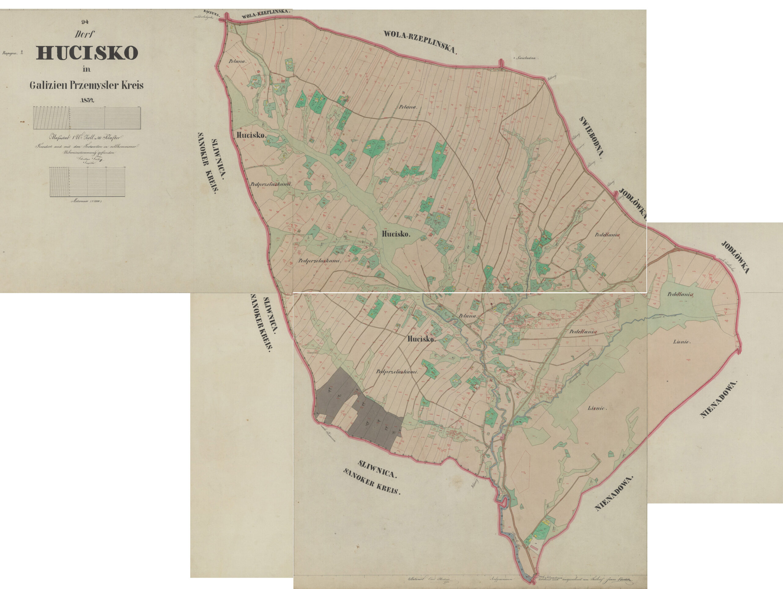
The cadastral map of the Polish village of Hucisko Nienadowskie, created by officials of the Austrian Empire in 1852 is available on the website of the Polish State Archives at Szukaj w Archiwach. The files at Szukaj w Archiwach include five images that, together, form the complete map.
The Dictionary of Polish Place Names (Nazwy Miejscowe Polski) explains the origin of place names in Poland and details how the place name changed over time.
The present-day village of Hucisko Nienadowskie is located in Podkarpackie Voivodeship, 28 kilometers northwest of Przemyśl. According to Polish Place Names, the name of the village was Nienadowa cum Huciska Nienaowskie in 1735, Hucisko in 1794, Huciscko nienadowskie in 1882, and Hucisko Nienadowskie in 1966.
Source: Rymut, Kazimierz, ed., Nazwy Miejscowe Polski (Place Names of Poland) – Krakow 1997, Volume III, page 500.
Click the link for a PDF copy of the Nazwy Miejscowe Polski entry for Hucisko Nienadowskie. Translated from the Polish, the entry reads:
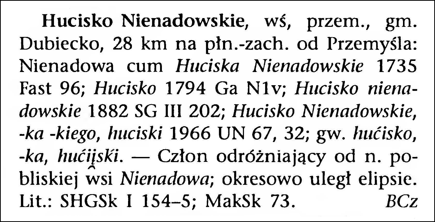
Hucisko Nienadowskie, village, Przemyśl, Dubiecko gmina, 28 km northwest of Przemyśl: Nienadowa cum Huciska Nienadowskie 1735 Fast 96; Hucisko 1794 Ga N1v; Hucisko nienadowskie 1882 SG III 202; Hucisko Nienadowskie, –ka –kiego, huciski 1966 UN 67, 32; jargon hućisko, –ka, hućiḽski. – Clause distinguishing it from the name of the nearby village of Nienadowa; periodically ellipsized. Lithuanian: SHGSk I 154-5; MakSk 73. BCz
The Słownik Geograficzny Królestwa Polskiego i Innych Krajów Słowiańskich (Geographical Dictionary of the Kingdom of Poland and other Slavonic Countries) includes an entry for the village of Hucisko Nienadowskie in Dubiecko Parish.
Source: Sulimierski, Filip, Bronisław Chlebowski, and Władysław Walewski, eds., Słownik Geograficzny Królestwa Polskiego i Innych Krajów Słowiańskich (Geographical Dictionary of the Kingdom of Poland and other Slavonic Countries) – Warsaw 1882, Volume III, page 202.
Click on the link for a PDF copy of the first Słownik Geograficzny entry for Hucisko Nienadowskie (Dubiecko Parish). Translated from the Polish, the entry reads:
11.) H[ucisko] Nienadowskie, a village in Przemyśl County, 32 kilometers northwest of Przemyśl and 6 kilometers northwest of the post office in Dubiecko. To the west it borders Huta Drohobycka and Drohobyczka, to the south Śliwnica and Nienadowa, to the east and north Jarosław County, namely Kramarzówka, Jodłówka, and Świebodna. The area is hilly. On the northwest side of the village, one point rises to 404 meters, and on the county border it reaches Raczyn, 452 meters. To the south of the village lies the Jodłowski Forest, with a peak 378 meters high. Through the center of the village flows the Kamionka stream, a tributary of the San, and collects all its tributaries from the right and the left bank. The larger property (owned by Count Eustachy Dembiński) comprises 98 mórgs of arable land, 3 mórgs of meadows and gardens, 28 mórgs of pastures; the peasants have 494 mórgs of arable land, 39 mórgs of meadows and gardens, 101 mórgs of pastures, and 16 mórgs of forest. According to calculations from 1869, there were 95 houses and 545 residents; according to the schematism of 1881, there are 545 residents of the Roman Catholic religion. In the manor area, there is 1 house and 12 residents. The Roman Catholic parish is in Dubiecko.
The cadastral map of the Polish village of Dubiecko, created by officials of the Austrian Empire in 1852 is available on the website of the Polish State Archives at Szukaj w Archiwach. The files at Szukaj w Archiwach include nine images that, together, form the complete map.
Note that the village of Ruska Wieś (or Ruskawieś) occupies land on both sides of the San River, but also that the map does not show any bridge crossing the San in this area.
Older maps of the area around Dubiecko, Poland (such as the 1855 map below) clearly show the location of the village of Ruska Wieś across the San River from Dubiecko. However, current maps, (such as those on https://www.google.com/maps and https://mapa.szukacz.pl/) show no village called Ruska Wieś where it had appeared on 19th-century maps.
Nazwy Miejscowe Polski (Polish Place Names) has two brief entries about the village of Ruska Wieś in Dubiecko parish:
Source: Rymut, Kazimierz, ed., Nazwy Miejscowe Polski (Polish Place Names) – Krakow 1997, Volume 11, page 450.
Source: Rymut, Kazimierz, Barbara Czopek-Kopciuch, and Urszula Bijak, eds., Nazwy Miejscowe Polski (Polish Place Names) – Krakow 2015, Volume X11, page 68.
Both of these brief entries indicate that a village called either Ruska Wieś or Dubiecko Ruskie is now known as Wybrzeże. Unfortunately, the volume of Nazwy Miejscowe Polski (Polish Place Names) that would provide details about the multiple names of the village of Wybrzeże has not yet been published.
The Polish Wikipedia entry on Wybrzeże states that the village was originally called Dubiecko, from the 15th century until 31 Jul 1947 it was called Ruska Wieś, and from 03 Sep 1949 it was called Brzeżyna.
The Słownik Geograficzny Królestwa Polskiego i Innych Krajów Słowiańskich (Geographical Dictionary of the Kingdom of Poland and other Slavonic Countries) includes an entry for the village of Ruska Wieś in Dubiecko Parish.
Source: Chlebowski, Bronisław, Władysław Walewski, and Filip Sulimierski, eds., Słownik Geograficzny Królestwa Polskiego i Innych Krajów Słowiańskich (Geographical Dictionary of the Kingdom of Poland and other Slavonic Countries) – Warsaw 1889, Volume X, page 30.
Click on the link for a PDF copy of the Słownik Geograficzny entry for Ruska Wieś (Dubiecko Parish). Translated from the Polish, the entry reads:
2.) RuskaWieś, Ruthenian Ruskoje Selo, village, Brzozów powiat, on the right bank of the San, which bends here, bypassing the hill near Dubiecko (2 kilometers) and surrounds the village on three sides (from the west, north, and east). From the south, the village is surrounded by a forest on the Dział hills (414 residents) and Iskańska mountain (379 meters high). There is an island on the San. On the left side of the river lies part of the village with the parish church of St. Michael and the buildings of a larger estate. Elevation above sea level 290 meters and on the bank 232 meters. Part of the right bank of the San borders to the south with Polchowa and Iskań, the part on the left bank to the south with Podbukowina, to the west with Bachórzec and to the north with Dubiecko. The village has 107 houses (5 on the manor area) and 594 residents; 42 Roman Catholics, 539 Greek Catholics and 34 Jews. The larger land (Countess Jadwiga Weissenwolf) has 295 arable fields, 22 meadows and gardens, 51 pastures and 287 mórgs of forest; the smaller land has 436 arable fields, 23 meadows, 86 pastures, and 4 mórgs of forest. There is a primary school here. The Greek Catholic parish belongs to the Przemyśl district, Bircza deanery, and encompasses Polchowa, Płonno, and Podbukowina. The soil is fertile and silty. M. Maciszewski
The Dictionary of Polish Place Names (Nazwy Miejscowe Polski) explains the origin of place names in Poland and details how the place name changed over time.
The present-day town of Dubiecko in Podkarpackie Voivodeship was established in the year 1407 under Magdeburg Law. According to Polish Place Names, the new town took its name from a neighboring village called Dubiecko, and the former village of Dubicko is now known as Wybrzeże.
The name Dubiecko originates from the Ukrainian word дубец, meaning young oak, oak rod, twig, or rod. Through the years, the spelling of the town name appeared as Dubetsko in 1408, Dubeczco in 1426, oppidum Dubiecko in 1441, Dubyeczko in 1515, and finally as Dubiecko in 1589, 1794, 1881, and 1966.
Source: Rymut, Kazimierz, ed., Nazwy Miejscowe Polski (Place Names of Poland) – Krakow 1997, Volume II, page 450.
Click the link for a PDF copy of the Nazwy Miejscowe Polski entry for Dubiecko. Translated from the Polish, the entry reads:
Dubiecko, village, formerly a town, Przemyśl Voivodeship, Dubiecko gmina, 11 km east of Dynów: Dubetsko 1408 AGZ VIII 57; Dubeczco 1426 Łp I nr 1754; oppidum [oppidum is the Latin word for town] Dubiecko 1441 Sng II 137; Dubyeczko 1515, Dubiecko 1589 ZDz XVIII/1, 149, 60; Dubiecko 1794 Ga J1v; Dubiecko 1881 SG II 187; Dubiecko, -ka, dubiecki 1966 UN 67, 10. – The name was taken over from the name of the village of Dubiecko <*Dubiecsko, Ukrainian: Dubecsko, today [called] Wybrzeże, next to which a township under Magdeburg law was founded in the year 1407. The name is from the Ukrainian word dubec ‘young oak’, also ‘oak rod, twig, rod’, proto-Slavic *dǫbъcъ Spsł IV 188-9, with the suffix -sk-. Lithuanian: MakSk 60; RospSEMiG 79. BCz
In 1996, Kazimierz Rymut, a Polish linguist, onomastician, and professor of humanities, began publication of Nazwy Miejscowe Polski (Polish Place Names) an encylopedic dictionary of the names of places in present-day Poland. The title of each article in the dictionary is the name in its current official form, taken from the list of official names of towns in Poland from 1980-1982. Each article attempts to explain the origin of the place name and describe how the place name changed over time.
Kazimierz Rymut died on 14 November 2006, but the publication of additional volumes has continued after his death. The dictionary has been published in volumes as follows:
Volume I, (AB), published in 1996 Volume II, (CD), published in 1997 Volume III, (EI), published in 1999 Volume IV, (J-Kn), published in 2001 Volume V, (Ko-Ky), published in 2003 Volume VI, (L-Ma), published in 2005 Volume VII, (Mą-N), published in 2007 Volume VIII, (O-Mon), published in 2009 Volume IX, (Po-Q), published in 2013 Volume X, (Ra-Re), published in 2015 Volume XI, (Rę-Rs), published in 2015 Volume XII, (Ru-Rż), published in 2015 Volume XIII, (Sa-Si), published in 2016 Volume XIV, (Sk- Sn), published in 2017 Volume XV, (September), published in 2018 Volume XVI, (Stb- Sy), published in 2021
Volume I includes an introduction that describes the scope of work, a list of sources for the information in the dictionary, and a list of abbreviations. To help English-speaking genealogists understand the information included is Rymut’s dictionary, a translation of the introduction and list of abbreviations in Volume I of the series is provided below.
The Słownik Geograficzny Królestwa Polskiego i Innych Krajów Słowiańskich (Geographical Dictionary of the Kingdom of Poland and other Slavonic Countries) includes two entries for the village of Dubiecko, the first is in Volume II.
Source: Sulimierski, Filip, Bronisław Chlebowski, and Władysław Walewski, eds., Słownik Geograficzny Królestwa Polskiego i Innych Krajów Słowiańskich (Geographical Dictionary of the Kingdom of Poland and other Slavonic Countries) – Warsaw 1885, Volume II, pages 187-188.
Click on the link for a PDF copy of the first Słownik Geograficzny entry for Dubiecko Vol. II. Translated from the Polish, the entry reads:
Dubiecko (with Czerwonka), a town, Przemyśl County, lies on the left bank of the San, at 49°50′ north latitude, 40°4′ east longitude, on the government highway running from Przemyśl to Dukla, 3.5 miles from Przemyśl, on the very border of the administrative counties of Przemyśl and Brzozów. The area of the property includes: 52 large arable land, 20 meadows and gardens, 21 pastures; 237 smaller arable land, 24 meadows and gardens, 24 pastures, Austrian morgen. Population: Roman Catholic 690, Greek Catholic 114, Israelites up to 700, total 1,505; townspeople mainly coopers and shoemakers. A post office and two parishes are on site. The Roman Catholic parish belongs to the Dynów deanery of the Przemyśl diocese. A report of a visit to this parish by Bishop Sierakowski, from a manuscript by Andrzej Bobola, former parish priest and hospital superior in Dubiecko (1576), describes how the village of Dubiecko, once located near the San River where the settlement of Ruska Wieś now stands, was relocated by Piotr Kmita, voivode of Sandomierz, to its present location, and King Władysław Jagiełło, at Kmita’s request, granted the village town rights. According to Bobola, Piotr Kmita built a church dedicated to St. Nicholas there at the beginning of the 15th century and secured the parish priest’s income. According to local sources, this foundation dates back to 1407, which is all the more credible given that, in a document from 1408 (the will of Jan, canon and parish priest of Przemyśl), Mikołaj, parish priest of Dubiecko, is also mentioned among other witnesses. The heirs of the aforementioned Piotr Kmita enlarged the foundation, namely Mikołaj Kmita, castellan of Przemyśl and heir of Dubiecko, founded an altar and a prebend [a prebend is land or an endowment used to finance the church and its clergy] around 1447; his son, Dobiesław, voivode of Lublin, endowed the college with three mansionaries [a mansionary is a church sexton whose role was to provide maintenance to the church property] in 1471, from which time on, local parish priests began using the title of provost. In 1551, Stanisław Mateusz Stadnicki, then owner of Dubiecko, having abandoned the Catholic faith, sent Albert of Iłża, an apostate, from his Niedźwiedź estate in the Kraków diocese to Dubiecko. He ordered him to celebrate the Lutheran liturgy first in the hospital church and then in the parish church. He expelled the Catholic parish priest and confiscated the benefice grant. Stadnicki, having become a Calvinist, took under his care Franciszek Stankar, who had been forced to flee Krakow due to heresy. Stankar opened schools in Dubiecko to spread the Reformation, to which young people flocked from all over the world. Due to the spread of the Reformation, the Przemyśl chapter of 1562 resolved that the Dubiecko school, suspected of heresy by the board of the Przemyśl cathedral school, be dissolved. Around 1621, in Dubiecko, heretical prints, now very rare, were published under the name of Jan Szeliga. In 1588, Andrzej Stadnicki, son of the aforementioned Stanisław, cleared Dubiecko of heretical unrest and restored the Catholic cause to its former state. The former parish church, dedicated to Saints Mikołaj, Stanisław, and Marcin, formerly stood next to Dubiecko Castle; but Grzegorz Krasicki of Siecin, the starost of Dolina, demolished it in 1626 under the pretext that it hindered the castle’s defense against enemy attacks. Parish services were moved to the Church of the Exaltation of the Holy Cross in the suburbs, which stands on the same site as the present church. In the 18th century, a new church was built thanks to the efforts of Michał Witosławski, a Przemyśl canon and Dubiecko parish priest, funded by contributions from the faithful. It was consecrated in 1755 by Wacław Sierakowski, Bishop of Przemyśl, under the patronage of the Holy Apostles Simon and Jude. Family tradition and Dubiecko archives attribute the construction of the parish church to Anna Krasicka, née Starzechowska, widow of Jan, castellan of Chełm, as confirmed by her portrait in the church, which depicts her holding a plan of the Dubiecko church. In addition to the Church of the mansionaries of the Holy Cross and the Church of the Hospital of the Poor of the Holy Spirit, records also mention the Chapel of St. Anne, located outside the city in the direction of Babice, near the road leading from Dubiecko to the settlement of Nienadowa. On February 3, 1735, Ignacy Krasicki, Bishop of Warmia and a famous poet, was born in the Dubiecko Castle. To the Roman Catholic parish in Dubiecko belong: Drobobyczka, Huta Drohobycka, Hucisko Nienadowskie, Nienadowa, Polechowa and Słonne, Przedmieście, and Ruska Wieś. The total number of Catholics in the entire parish is 5,252, of Israelites 1,696. The Greek Catholic parish of the Bircza deanery includes, in addition to the town of Dubiecko, the following towns: Przedmieście, Nienadowa, Hucisko, Śliwnica, Drohobyczka, and Bachorzec (until 1871, St. John’s Orthodox church stood here, which burned down that year); the total number of Greek Catholic parishioners is 636. The records of the Greek Catholic parish of Dubiecko contain evidence that such a parish had existed for a long time. In 1591, Łuka Teleśnicki was priest in Dubiecko under the inheritance of Stanisław Krasicki, castellan of Przemyśl. In 1674, Wasyl Korytnicki purchased the Dubiecko parish for 200 Polish zlotys for himself, his wife, and his descendants from Jerzy Krasicki, heir to Dubiecko. In 1747, Grzegorz Teleśnicki, a local priest, bought the Dubiecko popostwo [a popostwo was a Ruthenian parish district] for himself and his descendants for 354 Polish złoty. In 1753, a new church was built at the expense of the court and the community in Dubiecko. There are also documents from 1774 and 1775: the first, a donation of a piece of land for the church in Bachórz by Antoni Krasicki of Siecin, Count of Krasiczyn, Colonel of the Crown Army, Knight of the Order of St. Stanislaus, the Dubiecki and Ruskowiejski estates, the keys of the hereditary lord; the second, a gift made by the same Antoni Krasicki to Father Jerzy Teleśnicki, parish priest in Dubiecko, and, as a result of this gift, a decree nominating the said parish priest in Skopowo as parish priest in Dubiecko, issued in Latin by Atanazy Szeptycki Szeptycki, Greek Catholic Bishop of Przemyśl, at the episcopal residence in Straszewice on March 22, 1775. Since 1588, when Stanislaw Krasicki of Siecin, steward of Anna Jagiellon, the Przemyśl castellan, acquired Dubiecko (with Sliwnica, Przedmieście, Drohobyczka, Połchów, Rybno, Podbukowina, Słonne Wola Jawornicka, Ruska Wieś, and Przysada), thus since the 16th century these estates have belonged to the Krasickis; only Dubiecko Castle and Śliwnica belong to Count Stanisław Konarski, born of Krasicka. The Dubiecko castle holds the archives of the Krackis and related houses, as well as letters from Bishop Ignacy, his portrait painted by Mieris, and three volumes of his manuscripts. A beautiful park stands on the banks of the San River. Around 1608, Dubiecko burned down; that same year, Jan Żabczyc published a poem in Krakow lamenting the fire. B[ronisław] R[ozwadowski]
The second entry for Dubiecko in the Słownik Geograficzny Królestwa Polskiego i Innych Krajów Słowiańskich (Geographical Dictionary of the Kingdom of Poland and other Slavonic Countries) is in Volume XV (Part 1).
Source: Chlebowski, Bronisław, Józef Krzywicki, Filip Sulimierski, and Władysław Walewski, eds., Słownik Geograficzny Królestwa Polskiego i Innych Krajów Słowiańskich (Geographical Dictionary of the Kingdom of Poland and other Slavonic Countries) – Warsaw 1900, Volume II, page 445.
Click on the link for a PDF copy of the second Słownik Geograficzny entry for Dubiecko Vol. XV. Translated from the Polish, the entry reads:
Dubiecko, city, Przemyśl powiat. In 1508 Barbara Kmita, the wife of the castellan of Przemyśl, paid from Dubiecko and villages belonging to it 31-1/2 grosze and 6 denarii [the denarius was worth about 1/10 of a grosz]. The city gives a czopowe [czopowe is a tax on the production, import, and sale of alcoholic beverages] of 5 grzywna [an old Polish monetary unit, equivalent to the Western mark] and 7 grosze. In 1515, she paid 8 grosze, and from the mill 3 grosze. In 1589 she gave 9 florins from 22 craftsmen and merchants, and from 3 wheel mills. Near the city is the Dubiecko Przedmieście and Dubiecko-Ruskie (today Ruska Wieś).
According to Wikipedia, the Parish of the Immaculate Heart of the Blessed Virgin Mary in Dubiecko currently serves the villages of Dubiecko, Nienadowa Dolna, Przedmieście Dubieckie, Słonne, Śliwnica, Wybrzeże, and Winne-Podbukowina.
The cadastral map of the Polish village of Dubiecko, created by officials of the Austrian Empire in 1852 is available on the website of the Polish State Archives at Szukaj w Archiwach. The files at Szukaj w Archiwach include four images that, together, form the complete map.
The Gesher Galicia Map Room includes a high-resolution version of the cadastral map of Dubiecko with the individual images stitched together. One of the great features of the maps in the Gesher Galicia Map Room is that the user can zoom in and out of the maps to view either an overview of the map or concentrate on the smallest details.