The United Polish Genealogical Societies Conference – 2008

The 2008 conference of the United Polish Genealogical Societies has been announced. The conference will be held in Salt Lake City from April 18-21, 2008.

The conference organizers are writing a blog at http://upgs.wordpress.com to communicate details about the conference, introduce the speakers, and provide day-by-day information about the activities at the conference.

Photo of the Family History Library in Salt Lake City

Family History Library, Salt Lake City

SOURCE: The Family History Library in Salt Lake City. Photographed by Stephen J. Danko 25 Nov 2006.

The 2008 Conference will include some exciting new features:

  • Video conferencing with genealogists in Poland
  • Online participation by a famous writer of Polish research materials
  • A BYU Roundtable on Publishing Your Family History

Topics discussed will include information about German Poland, Russian Poland and Austrian Poland. In addition to the scheduled lectures, the conference will feature:

  • Experts on hand to help translate documents in Russian, Polish and German
  • Time to conduct your own research at the Family History Library

Speakers will include the following, appearing in person:

  • Tomasz Nitsch, administrator of Poland’s GenPol
  • Sonja Hoeke-Nishimoto, Family History Library
  • Kahile B. Mehr,  Family History Library
  • Daniel Schlyter, Family History Library
  • Ceil Wendt Jensen of Michigan Polonia

Speakers also include the following who will participate on-line:

  • Katarzyna Grycza of Discovering Roots
  • Łukasz Bielecki of the Poznan Project
Posted in Daily Journal | Tagged | Comments Off on The United Polish Genealogical Societies Conference – 2008

Online Gazetteers of Poland

Specifying a place name in Poland requires knowledge of not only the name of the village, but also the name of the gmina, powiat, wojewódstwo or gubernia, and country.

The name of the country to which a village in central and eastern Europe belonged changed relatively frequently in the past, and those country names can generally be determined by examining published histories and historical maps.

The other divisions: gmina (municipality), powiat (district), and wojewódstwo or gubernia (province) can usually be found in gazetteers.

Three very useful gazetteers of Poland are available online.

Słownik Geograficzny Królestwa Polskiego i Innych Krajów Słowiańskich

The Słownik Geograficzny Królestwa Polskiego i Innych Krajów Słowiańskich (The Geographical Dictionary of the Kingdom of Poland and Other Slavonic Countries) is available in book form, on microfilm, on CD, and is now available online. It is most useful for the period 1864-1918.

The first version is available through the University of Warsaw and uses the DjVu plug-in to view the pages of the Słownik. You may need to install the plug-in before you can view the pages. Select Tekst słownika (Text of the dictionary) on the left side of the page and you’ll be presented with links to selected pages in all the volumes. Select a link to a page close to the one you want to view and the DjVu plug-in will show the page on your screen. From there, you can select any specific page number, or you can move forward or backward page by page using the arrows near the top of the page. This interface is very similar to that found on the CD version of the Słownik.

The second version is available through the Małopolska Digital Library and also uses the DjVu plug-in. Click on the volume you want to view, on the next screen click Show Publication Content!, and on the next screen click Browse Publication. At this point you’ll see the same DjVu interface as available on the University of Warsaw site and on the CD. Again, you can select a specific page number or move forward and backward using the arrows near the top of the page.

The third version is available through the Domena Internetowych Repozytoriów Wiedzy (Internet Domain of Information Repository). This version is searchable. To search, look for Wyszukiwanie (look up) . Type the name of the village in the text box after either w haseł (in header) or w tekście (in text), click the checkbox szukaj w całej serii (search in the entire series) and you’ll be presented with a list of the places in the Słownik where that village name is mentioned. The search isn’t perfect. A search for the village Dubiecko doesn’t find the entry in volume 2, but it does find the entry in volume 15, part 1.

When searching for an entry about a village, search using w hasłach. If you’re interested in all entries that mention your village, use w tekśie. Polish characters must be used when using the search function. To browse the text, select a Tom (Volume) and click on poprzednia strona (previous page), pobierz skan (capture scan), or następna strona (next page). To save an image or print an image, right click on the image and select Save picture as… or Print picture…

You can also go directly to a specific page by scrolling down to the idź do (go to) selection on the lower left of the page. Select a tom (volume) and strona (page) and click on the arrow to the right of the strona entry box.

The Słownik Geograficzny presents information in a paragraph format. The information is in Polish and includes many abbreviations and archaic terms. Many of the abbreviations are explained in Volume I on pages 13-14. In Volume II, pages 929-936, there is a list of powiats with the next larger administrative subdivision (Gubernia of the Russian Empire, Galicia in Austria, or Province of the Kingdom of Prussia)

Skorowidz miejscowości Rzeczypospolitej Polskiej

The Skorowidz miejscowości Rzeczypospolitej Polskiej z oznaczeniem terytorjalnie im właściwych władz i urzędów oraz urządzeń komunikacyjnych (Index of Placenames of the Republic of Poland with corresponding governmental agencies and offices, including communication facilities) is the gazetteer of the Second Polish Republic and is useful for the period from 1918-1945.

The online version is provided by the Digital Library of Wielkopolska. Click on Show Publication Content! and then Browse Publication. This site uses the DjVu viewer and allows you to select a page, browse pages using the arrows near the top of the page, and allows you to print or save a page.

The Skorowidz presents information in a tabular format:

  • Miejscowość i jej charakter: Place and its character (type of place)
  • Terytorjalnie właściwe władze i urzędy oraz urządzenia komunikacyjne: Characteristic territorial authorities and offices as well as transportation devices
  • Gmina: Municipality
  • Powiat polityczny: Political district
  • Wojewódsto: Voivodeship or Province
  • Poczta i telegraf (telefon): Post office and telegraph (telephone)
  • Stacja kolej. z odległością km.: Railway Station with distance in kilometers
  • Najbliższa linja komunik., autobus., z odległością km.: Nearest transit line (bus) with distance in kilometers
  • Sąd: Court
  • Grodzki: Municipal
  • Okręgowy: District
  • Urzędy parafjalna: (rz-kat., gr-kat., wsch. słow., orm.-kat., prawosł., ewang., ew.-ref.): Parish Offices (Roman Catholic, Greek Catholic, Eastern Slavonic, Armenian Catholic, Orthodox, Evangelical Lutheran, Evangelical Reformed)

Copyright © 2007 by Stephen J. Danko

Posted in Daily Journal | Tagged | 4 Comments

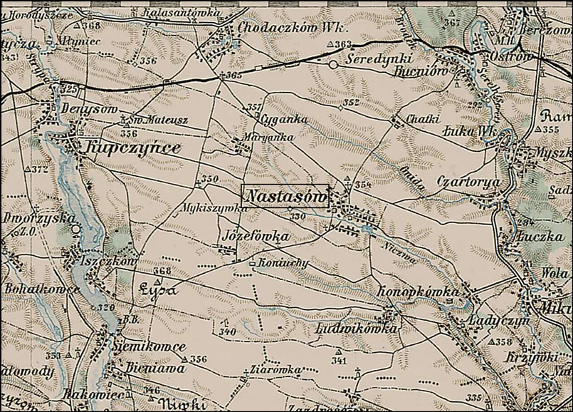
Map of the Village of Nastasiv (Nastasów), Ukraine

The Military Maps of the Austrian Empire provide a great complement to the Słownik Geograficzny Królestwa Polskiego i Innych Krajów Słowiańskich (The Geographical Dictionary of the Kingdom of Poland and Other Slavonic Countries) because the maps and the gazetteer were prepared in the same time period.

Both the maps and the gazetteer were prepared over many years. The map that includes the village of Nastasów, Congress Kingdom of Poland (now Nastasiv, Ukraine) was published in 1889. The Słownik Geograficzny entry I translated yesterday was published in 1885.

Map of Nastasow - Nastasiv

Map of the Village of Nastasiv (Nastasów) and Vicinity

SOURCE: 3rd Military Mapping Survey of Austria-Hungary, Sheet 43-49, Kolomea. Online http://lazarus.elte.hu/hun/digkonyv/topo/200e/43-49.jpg; downloaded 01 Aug 2007.

On this map, one can find many of the villages mentioned in the Słownik Geograficzny entry for Nastasów except for Draganówka, which is on a different map (Sheet 43-50, Brody), and a few other villages such as Strusów which are just out of the view on this map. The first few letters of the names of the villages of Myszkowice and Mikulińce are just visible on the eastern edge of this map, and the tops of the letters of the village of Zadrość are visible at the southern edge of this map.

In combination with the Słownik Geograficzny entry, the location and lifestyle in Nastasów really starts to come to life.

The Family History Library (FHL) has microfilmed copies of the records from the parish church in Nastasów from 1786-1832. The FHL has also microfilmed copies of the records of the Roman Catholic Consistory in L’viv from 1600-1948 and the Greek Catholic Consistory in L’viv from 1607-1945. The records from the Consistory in L’viv should include records from Nastasów, and with luck will include more than just the 1786-1832 records in the microfilms for Nastasów itself.

With this information, I’m ready to start looking for the records of my stepmother’s Halaszyn ancestors.

Copyright © 2007 by Stephen J. Danko

Posted in Halaszyn | Tagged , | 2 Comments

The Ukrainian Village of Nastasiv (Nastasów)

I’m just finishing a class in Research – Ukrainian Ancestors with the National Institute for Genealogical Studies.

I took that course for two main reasons: my step-grandmother, Tekla Halaszyn, was from a village in Ukraine and some of my Polish relatives once lived in the territory that is now Ukraine and so their records are located there.

During the course, I tried to find the name of the village where Tekla Halaszyn was born. Her immigrant passenger manifest provided the answer: she was from Nastasów, now called Nastasiv, near Ternopil’, Ukraine.

I looked for the village of Nastasów in the Słownik Geograficzny Królestwa Polskiego i Innych Krajów Słowiańskich (The Geographical Dictionary of the Kingdom of Poland and Other Slavonic Countries) and found quite a lengthy description of the village.

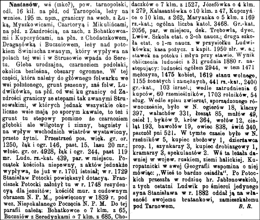
The Slownik Geograficzny Entry for Nastasow

Słownik Geograficzny Entry for Nastasów

Source:  Sulimierski, Filip, Chlebowski, Bronisław, and Władysław Walewski, eds., Słownik Geograficzny Królestwa Polskiego i Innych Krajów Słowiańskich (Geographical Dictionary of the Kingdom of Poland and other Slavonic Countries) – Warsaw 1885, Volume VI, page 927.

Click on the link for a PDF copy of the Slownik Geograficzny Entry for Nastasow. Translated from the Polish, the entry reads:

Nastasów, village (town?), Tarnopol Powiat [District], 16 kilometers to the south not far from Tanopol, it lies on a hill 195 meters above sea level, it borders with Łuka, Myszkowice, Czartorya, and Mikulińce on the east, with Zazdrość on the south, with Bohatkowce and Kupczyńce on the west, with Chodaczków, Draganówka and Bucziów on the north, it lies on the so-called Świniucha creek, which flows in the fields of this village and in Strusów it flows into the Seret river.

It has fertile soil, black-earth fields, treeless surroundings, vast territory.

In this part, which belongs to the main grange [large manorial farmstead] located in the village, there are wheat fields, while the Ludwikówka grange to the south of the village towards the border of Zazdrość borders with the so-called Strusowski steppes in which all the surrounding villages still have a considerable piece, also the land here is steppe despite the deep black earth, but is damp and cold, boggy and is influenced by the winds drawn from the east, and so there is rye.

The expanse has more than 1250 mórgs [1 mórg in the Austrian partition = 1.422 acres] of arable land, 149 mórgs of meadows and gardens, 15 mórgs of pastures, 20 mórgs of forests; the manor has 4928 mórgs of arable land, 244 mórgs of meadows and gardens, 119 mórgs of pastures.

There is population of 439 Roman Catholics and there is a parish there.

The origins of the church are uncertain, in deeds however it has become known that it already existed in the year 1701; in the year 1729 Stanisław Potocki expanded the grant.

Franciszek Potocki established a residence for the Jesuits here in the year 1728; a masonry church with amazing pictures of the Blessed Virgin Mary was dedicated in the year 1839 under the protection of Our Lady Conceived without Sin.

To this parish belong: Bohatkowce about 7 kilometers away with 65 people, Buczniów and Serdynki about 7 kilometers away with 685 people, Chodaczków about 7 kilometers away with 1527 people, Józefówka about 4 kilometers away with 279 people, Kalasantówka about 10 kilometers away with 47 people, Kupczyńce about 10 kilometers away with 262 people, Maryanka about 5 kilometers away with 169 Roman Catholics; the overall number is 3468 Catholics.

There are 2056 Greek Catholics, there is a parish there belonging to the Trębowla deanery in the Lwów diocese.

There is a full-time school with 2 teachers; a second full-time school with one teacher in the hamlet of Ludwikówka; there is a lending bank with 1950 Rhenish złoty in Austrian currency; a pond on the creek and a mill on the pond.

The result of the calculation of the population on 31 December 1880 is as follows: total population 2944, among these are 1471 men, 1475 women, 1619 unmarried, 1155 married men and women, 441 Roman Catholics, 2400 Greek Catholics, 103 Jews; as for employment, there are 6 merchants, 60 craftsmen, 1703 farmers, and 54 servants.

According to the registrations of animals prepared at the same time, in Nastasów there were 18 stallions, 397 mares, 331 geldings, 85 moose cows, 49 mules, 1 donkey, 9 bulls, 364 cows, 12 oxen, 193 calves, 19 buffalo, 838 sheep, 340 pigs, and 521 beehives.

At this time there were in Nastasów 5 butchers, 1 grain merchant, 1 leaseholder, 3 tavern owners, 1 trinket merchant, 3 stall keepers, and 2 speculators.

This village was formerly located in the Ruś [Ruthenian] Województwo [Province], Halych Land.

Kuropatnicki in his Geography mentions this saying: “The village is very settled”.

After the Potockis, it [Nastasów] passed to the family of Count Jabłonski; in the end Ludwik, after the death of the only son Stanisław in the year 1882, ceded it to the property of his nephews residing in Tarnów.

                                                                              Bolesław Rozwadowski

That’s quite a lot of information. The translation still needs work, and I have to check the spellings of the names of the villages mentioned, since many of the village names were inflected in the Polish.

And I need to look this up on a map of the appropriate time period. And I need to check the Family History Library Catalog for microfilmed records, since the parish church was located in Nastasów. And I…

Well, all in good time.

Copyright © 2007 by Stephen J. Danko

Posted in Daily Journal, Halaszyn | Tagged | 8 Comments

Ethics in Publishing Family Histories

Facts can’t be copyrighted.

I was surprised when a friend of mine who practices copyright law first passed this information on to me. Reflecting on this statement, it makes sense. How could anyone claim copyright to the name of the ship on which their immigrant ancestor sailed, or the date of death of their great great grandfather, or the amount that an ancestor paid in monthly rent?

Recent legal opinion has even decided that certain compilations of facts, such as telephone directories, are not subject to copyright.

But what about compiled genealogies? What can I include in a published genealogy without infringing on someone else’s rights? And what rights do I have to the compilations I produce?

Genealogists generally like to share their discoveries by compiling a family tree and providing it to family members or other people who are researching the same line. Many genealogists share their discoveries online, posting GEDCOM files to sites such as RootsWeb, Ancestry.com, or to one of the new Web 2.0 applications for collaborative efforts in Family History Research.

On more than a few occasions, I’ve read tales of how someone shared their pedigree with someone else, only to find their own work published on the Internet without permission, often without any citation of the source of the pedigree. Those whose hard work has been published without their consent have sometimes been furious about having their work published.

So, what recourse does someone have when they find their work published without their consent and without attribution? Do those who produce compiled genealogies own copyright to their compilations of names, dates, and locations?

The facts themselves are not copyrightable. That much is clear. Certain compilations such as phone books are not copyrightable. But what about compiled genealogies?

Since compiled genealogies involve discovering relationships, finding facts in unusual locations, and carefully assembling the information to reflect the structure and organizations of ancestral families, complied genealogies are probably considered creative works and, therefore, are probably protected by copyright. The owner of the copyright to a compiled genealogy would probably have available whatever recourse is available under the applicable copyright laws.

So, can I incorporate several generations of genealogical information compiled by someone else into my own family history and publish the work without permission of the original compiler? Frequently, compiled genealogies are published without information about the person who conducted the research or compiled the work. But, anonymous works are still protected under the copyright laws.

I don’t know the answers to these questions. I’m not a copyright attorney and my opinions are mine alone. As others including footnoteMaven have recently pointed out, even the opinion of someone licensed to practice law is only an opinion. Decisions on copyright issues are generally made by the courts.

To protect the integrity of my work, I can:

  • Incorporate information from other compiled genealogies into my own only after obtaining copies of source material used to support that information.
  • Where appropriate, cite the original compiled genealogy as a source. This source will be a derivative source, but a source, nonetheless.
  • Where possible, obtain permission from the original compiler before incorporating the work into my own published genealogy.

What about sources? Many of the sources genealogists use in their work are publicly available sources such as vital records, census records, and immigration records. Some sources, though, are oral histories, letters, diaries, phone conversations, and e-mail communications. Each of these sources is protected by copyright in and of themselves. Generally, citing sources without reproducing the original work is considered acceptable.

Still, great aunt Marge may not want her private letters to me cited as a source in a published genealogy.

And what about information on living individuals? Genealogists agree that it is never acceptable to publish information on living individuals in a publicly available medium. How about publishing information on living individuals in a family history available only to those named in the work? What about publishing potentially sensitive information such as illegitimate births, same sex relationships, and causes of death?

To avoid disenfranchisement of my relatives and the sources of personal communications, I can:

  • Request permission to include personal communications as sources in compiled genealogies.
  • Never publish information about living individuals in a publicly published genealogy.
  • Request permission to include information about living individuals in family histories destined for distribution to family members.
  • Request permission to include potentially sensitive information from those who might be impacted by publishing that information.

These suggestions will be difficult to reduce to practice. Even if I get permission from the person most closely affected by potentially sensitive information, some other member of the family may be aghast that the information is included.

While my decisions may not always be perfect, I’ll evaluate the information I intend to publish and decide what to include and what information for which to request permission on a case-by-case basis . And I’ll certainly have to consider whether something I publish has the potential to harm someone else.

Even this approach is not without an ethical dilemma. By choosing not to report certain information I may risk compromising the integrity and accuracy of my work.

What to do? Well, I’ll do the best that I can.

Copyright © 2007 by Stephen J. Danko

Posted in Daily Journal | 37 Comments

Voivodeships, Gubernias, and Departments in Russian Poland

After the formation of the Polish-Lithuanian Commonwealth in 1569, the chief administrative division in Poland was the Wojwództwo, translated into English as Voivodeship, Administrative District, or Province.

After the third partition of Poland on 24 Oct 1795, Poland ceased to exist as a nation. The territory had been divided among Russia, Prussia, and Austria. Polish territory in the Russian Partition was divided into sixteen Gubernias. These divisions were changed repeatedly after the partitions.

The Napoleonic Wars led to the formation of the Duchy of Warsaw on 09 Jun 1807 from some of the territory formerly partitioned by Prussia and Russia. On 14 Oct 1809, part of the Austrian partition was also included in the Duchy. The Duchy was divided into Departments, rather than Gubernias.

In 1815, the Congress of Vienna redistributed the Polish lands and created the Congress Kingdom of Poland and, in 1816, the Congress Kingdom of Poland was divided into eight Voivodeships.

This terminology was short-lived, however . After the November Uprising, Russia tightened its grip on the Congress Kingdom of Poland and, on 07 Mar 1837, the administrative divisions were once again called Gubernias. In 1844, the number of Gubernias was reduced from eight to five.

In 1867, after the failed January Uprising, the structure of the Gubernias changed once again. Moreover, the Russian government no longer referred to the territory as the Congress Kingdom of Poland, but as the Vistulan Country or Vistula Land. The names of the Gubernias after 1867 were:

  • Kalisz Gubernia
  • Kielce Gubernia
  • Lublin Gubernia
  • Łomża Gubernia
  • Piotrków Gubernia
  • Płock Gubernia
  • Radom Gubernia
  • Siedlce Gubernia
  • Suwałki Gubernia
  • Warsaw Gubernia

These are the Gubernias seen on maps of the Congress Kingdom of Poland from the late 19th and early 20th centuries .

Finally, in 1912, Chełm Gubernia was formed from parts of the Siedlce and Lublin Gubernias. Chełm Gubernia was administered directly by the Russia Empire, while the other Gubernias were administered through the Vistulan Country.

And so, with all the changes that happened within the territory in this time period, it’s no wonder that anyone has questions about how to describe the location of a Polish village at any given point in history.

Copyright © 2007 by Stephen J. Danko
Posted in Daily Journal | 2 Comments

Using Maps and Gazetteers to Find the Parish for Szulmierz

When Eric first contacted me for help on how to find the records for his Polish ancestors, I showed the Słownik Geograficzny entry for the village of Szulmierz, the village in which his great grandfather was born.

The Słownik Geograficzny entry for Szulmierz did not mention the name of the parish for Szulmierz, but indicated that the reader should compare the entries for Sulmierz and Dunoch. The entry for Sulmierz stated that the parish was located in Niedzborz. The entry for Dunoch stated that the Dunoch was a forested area belonging to Kosiczyn, Szulmierz, Włosty and others, and that the parishes for this area were in Koziczynek and Lekowo.

So, which of these choices is the place where the records of the residents of Szulmierz are located?

Map of the Village of Szulmierz and Vicinity

Map of the Village of Szulmierz and Vicinity

SOURCE: 3rd Military Mapping Survey of Austria-Hungary, Sheet 38-53, Mlawa. Online http://lazarus.elte.hu/hun/digkonyv/topo/200e/38-53.jpg; downloaded 25 Jun 2007.

The map of Szulmierz also shows the locations of the parishes of Koziczynek and Lekowo.

Niedzborz is not on this map and, in fact, is too far from Szulmierz to be a reasonable distance to travel on foot, by horse, or by wagon. I conclude now that Sulmierz and Szulmierz were two different villages, and that the parish for Szulmierz must be either Koziczynek or Lekowo.

Fortunately for Erik, the Family History Library has microfilmed the records of both of these parishes.

Seeing the location of Szulmierz on a map came as a bit of a surprise to me, because Szulmierz is very close to some of my own ancestral villages in Poland. If you look at the far right of the map above, you’ll find the village of Klonowo, and if you look at the lower right hand corner, you’ll find Pałuki, the location of Klonowo’s parish.

And, if that wasn’t enough of a blogging coincidence, take a look at the village between Szulmierz and Koziczynek. It’s a village named Lipa – a village named for the linden tree. Jasia of Creative Gene recently wrote about her surname Lipa and the significance of the linden tree in Poland.

Gazetteers can provide a lot of information about a locality. Maps can provide a visual aid to the geography. The two, together, can provide more genealogical clues than either one alone.

Copyright © 2007 by Stephen J. Danko
Posted in Daily Journal | Tagged , | 1 Comment

The Map of the Polish Village of Pyrzowice

Historical maps of Poland are easier and easier to come by on the web.

Euratlas.com provides a series of maps of Europe through the past 2000 years, allowing the viewer to see how the map of Europe changed with time.

While these maps provide a good overview of Europe, most Polish genealogists will also want to see higher resolution maps.

Two of the best, high-resolution historical maps of Poland available on the web are the Illustrated Geographic Atlas from 1907 (on the website of the Polish Genealogical Society of America) and the Miltary Maps of the Austrian Empire from about 1900-1910. The Military Maps of the Austrian Empire cover much of central and eastern Europe, not just Poland.

The Polish village of Pyrzowice is included on both maps but, in the Illustrated Geographic Atlas, the name of the village is spelled Pyżowice. In Polish, the letters “rz” and “ż” are pronounced identically, so the spelling difference is not unexpected.

Map of Pyrzowice Poland and Vicinity

Map of the Village of Pyrzowice and Vicinity

SOURCE: 3rd Military Mapping Survey of Austria-Hungary, Sheet 37-50, Oswiecim. Online http://lazarus.elte.hu/hun/digkonyv/topo/200e/37-50.jpg; downloaded 27 Jul 2007.

Click on the map above to see a larger and more deailed image.

Not only is Pyrzowice shown on the Military Map of the Austrian Empire, but the parish of Sączów is also shown . Sączów is the place where the records for the village of Pyrzowice were maintained. Unfortunately, the Family History Library Catalog does not yet appear to have records from Sączów on microfilm.

I remember that, at a conference of the United Polish Genealogical Societies, a representative of the Family History Library showed the locations in Poland where the Library was planning to film records, and western Poland was on their schedule. With luck, Sączów may be one of the parishes to be filmed in the near future.

Tomorrow: How using gazetteers and maps together can help answer genealogical questions.

Copyright © 2007 by Stephen J. Danko

Posted in Daily Journal | Tagged | Comments Off on The Map of the Polish Village of Pyrzowice

The Polish Village of Pyrzowice

Yesterday, I wrote about the location of the Polish village of Pyrzowice at the end of the 19th century and beginning of the 20th century. An unambiguous way to identify the location at that time would be:

Pyrzowice, Ożarowice Gmina, Będzin Powiat, Piotrków Gubernia, Congress Kingdom of Poland

Of course, the village didn’t move around; it wasn’t located in physically different places at different times. However, because the borders of Poland changed, and the administrative districts in which Pyrzowice changed, it is important to modify the descriptors of the location to reflect the political boundaries at different times in history.

But how does one find these descriptors? The answer is to consult maps and gazetteers of the appropriate time period.

A valuable gazetteer of Poland for the late 19th century and early 20th century is the Słownik Geograficzny Królestwa Polskiego i Innych Krajów Słowiańskich (The Geographical Dictionary of the Kingdom of Poland and Other Slavonic Countries).

The village of Pyrzowice appears in volume IX on page 328 of that monumental work:

Slownik Geograficzny Entry for Pyrzowice

Słownik Geograficzny Entry for Pyrzowice

Source: Chlebowski, Bronisław, Władysław Walewski, and Filip Sulimierski, eds., Słownik Geograficzny Królestwa Polskiego i Innych Krajów Słowiańskich (Geographical Dictionary of the Kingdom of Poland and other Slavonic Countries) – Warsaw 1888, Volume IX, page 328.

Click on the link for a PDF copy of the Słownik Geograficzny entry for Pyrzowice. Translated from the Polish, the entry states:

Pyrzowice, a village and grange [large manorial farmstead], Powiat [District] będziński, Ożarowice gmina [municipality], Sączów parish; the village has 26 homes, 256 residents, 23 settlements, and 331 mórgs [about 1.388 mórgs per acre] in the manor; the grange has 4 homes, 1006 mórgs (in this 500 mórgs of cultivated land). The territory of the manor house belongs to the holdings of the Reverend Hugo Hohenlohe. In 1827, there were 22 homes and 105 residents. According to Długosz, in the 15th century the village of Pyrzowice was in the Sączów parish, the property of Stanisław Rudzki, the Count of Pilaw. It had 22 fields from which tithes of 6 grosze [pennies] was paid to the Bishop of Kraków; out of this, measures of barley and oats were given to the parish priest in Sżczów (Długosz, Liber Beneficiorum, volume II, page 202). In a second place, this historian provides different details, namely that Pyrzowice was the property of Jan Feliks Tarnowski, it had 12 fields from which tithes of 6 grosze from the fields was given to the Bishop of Kraków. The value of the tithes amounted to 1 grzywnas [historical silver coins worth several denarii] (Liber Beneficiorum, volume III, page 73).
Bronisław Chlebowski

The words and descriptions in square brackets are my own annotations.

Jan Długosz was a historian who included historical information about Polish villages in his multivolume work entitled Liber beneficiorum ecclesiae Cracoviensis (Book of the Benefices of the Bishopric of Krakow). This work is referenced in many places in the Słownik Geograficzny.

The name Bronisław Chlebowski at the end of the article is the name of the author of the article on Pyrzowice.

The name of the country in which the village of Pyrzowice was located at various times in history include:

  • 1025-1569 – Kingdom of Polan (Królestwo Polskiego)
  • 1569-1795 – Polish-Lithuanian Commonwealth (Rzeczpospolita Obojga Narodów)
  • 1795-1807 – Kingdom of Prussia
  • 1807-1815 – Duchy of Warsaw
  • 1815-1864 – Congress Kingdom of Poland
  • 1864-1918 – Congress Kingdom of Poland; also called Vistulaland (Privislinskii krai)
  • 1918-1945 – Republic of Poland (Rzeczpospolita Polska), although this name was not officially established until 1921; also called the Second Republic of Poland
  • 1945-1989 – People’s Republic of Poland (Polska Rzeczpospolita Ludowa)
  • 1989-Present – Republic of Poland (Rzeczpospolita Polska); also called the Third Republic of Poland

Tomorrow: Maps of Poland from the late 19th and early 20th centuries.

Copyright © 2007 by Stephen J. Danko
Posted in Daily Journal | Tagged | 1 Comment

Questions and Answers: How Do I Specify the Exact Locations of Polish Villages?

Erik, who previously wrote to me asking how to find ancestral records in Poland, has another question about Polish research. He asks about the proper way to enter the names of Polish villages in a family history to reflect the political landscape at the time one’s ancestors lived there.

This is a great question and a particularly difficult one to deal with for Poland, since the borders of Poland changed many times throughout history and the political subdivisions changed as well.

To record the location of a Polish village, one must not only where your ancestors lived, but when they lived there. Eric’s ancestors were from the villages of Pyrzowice and Szulmierz, and the discussion below is specific to those villages.

  • From 1569-1795, Pyrzowice and Szulmierz were part of the Polish-Lithuanian Commonwealth, a state that covered a large portion of central and eastern Europe.
  • Beginning in 1772, the Commonwealth was partitioned between Russia, Prussia and Austria. As best as I can tell on the maps I’ve looked at so far, Pyrzowice and Szulmierz both remained in Poland until the third partition in 1795. At that time, both of these villages were incorporated into the Kingdom of Prussia where they remained from 1795-1807.
  • The Napoleonic Wars resulted in another change in the boundaries, and between 1807-1815 both Pyrzowice and Szulmierz belonged to the Duchy of Warsaw, under French authority.
  • After Napoleon’s defeat, Pyrzowice and Szulmierz were part of a state that was established by the Congress of Vienna in 1815 and existed under control of Russia. The name Congress Kingdom of Poland is used to describe this region between 1815 and 1918, although the names Congress Poland and Kingdom of Poland are also used. The name Vistulaland is also sometimes used to refer to the Congress Kingdom of Poland between 1864-1918.
  • Poland regained its independence and became known as the Republic of Poland between 1918-1945, but was also referred to as the Second Republic of Poland.
  • In June 1945 at the Yalta Conference, Poland’s borders were completely changed and the new country was known as the People’s Republic of Poland. This name was used until the overturn of the Communist government in 1989.
  • Since 1989, Poland has been officially known as the Republic of Poland (Rzeczpospolita Polska), although it is also referred to as the Third Republic of Poland.

Erik’s great grandparents were born in the late 19th and early 20th centuries, a common time period for many Polish immigrants to America. Both of Erik’s great grandparents were born in the Congress Kingdom of Poland or Vistulaland.

In a previous article, I reported that, at the time Erik’s great grandparents were born, the village of Szulmierz was in the Regimin Gmina, Ciechanów Powiat, Płock Gubernia, Congress Kingdom of Poland. Gmina may be defined as a municipality, Powiat may be defined as a district, and gubernia may be defined as a province. I would enter the name of this village in my genealogy software as:

Szulmierz, Regimin Gmina, Ciechanów Powiat, Płock Gubernia, Congress Kingdom of Poland

This should be enough detail to allow someone else to find the village . Because several Polish villages in different parts of the country may have the same name, it’s important to list the Gmina, the Powiat, and the Gubernia, if known.

Sometimes, one will see the name of the powiat written as powiat chiechanowski. This is the adjectival form of the powiat name. Ciechanów Powiat uses the noun form of the powiat name. Likewise, one may see the name of the gubernia written as gubernia płockiej, which is also an adjectival form . Either is acceptable, but the noun form of the name might be more palatable to those whose native language is English.

At the time Erik’s great grandparents were born, the village of Pyrzowice was in the Ożarowice Gmina, Będzin Powiat, and Piotrków Gubernia of the Congress Kingdom of Poland. I would write the name in my genealogy software as:

Pyrzowice, Ożarowice Gmina, Będzin Powiat, Piotrków Gubernia, Congress Kingdom of Poland

The adjectival form of the powiat name is powiat będziński, and the adjectival form of the gumbernia name id gubernia piotrkowskiej.

Many genealogy programs won’t allow the entry of the Polish diacritical marks, and so you may have to just leave the diacritical marks off.

Tomorrow: The Słownik Geograficzny entry for Pyrzowice.

Posted in Daily Journal | Comments Off on Questions and Answers: How Do I Specify the Exact Locations of Polish Villages?