During a recent trip to Hong Kong, I visited the Hong Kong Avenue of Comic Stars, an area of Kowloon Park with statues of of characters from Hong Kong comics.
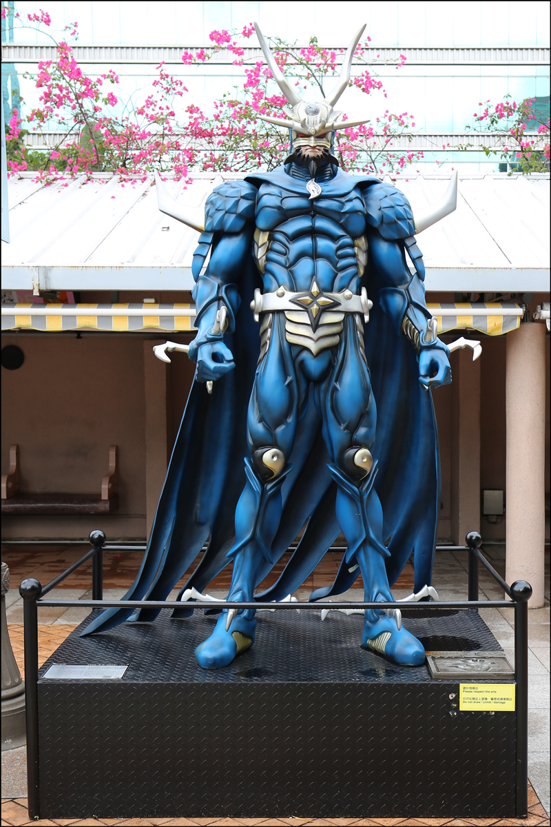
Cloud was drawn by artist Ma Wing-shing as a character in the comic Storm Riders. In the comic, two fellow disciples, Cloud and Wing, rise to fight in order to avoid disaster.
Cloud SOURCE: Cloud (Kowloon Park, Yau Tsim Mong District, Hong Kong Special Administrative Region of the People’s Republic of China); photographed by Stephen J. Danko on 16 April 2019.
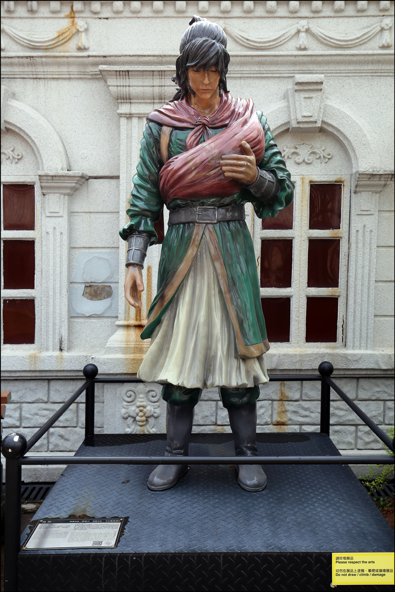
Chan Lok Kwan was drawn by artist Szeto Kim-kiu as a character in the comic Kowloon Walled City. In the comic, Chan Lok Kwan hides himself in the Kowloon Walled City to escape the hunting and killing by the big boss.
Chan Lok Kwan SOURCE: Chan Lok Kwan (Kowloon Park, Yau Tsim Mong District, Hong Kong Special Administrative Region of the People’s Republic of China); photographed by Stephen J. Danko on 16 April 2019.
Dragon Lord was drawn by artist Khoo Fuk-lung (James) as a character in the comic Kowloon Walled City. In the comic, Dragon Lord is a warrior from heaven responsible for safeguarding the Sky Fixer, an artefact that maintains the balance of the universe.
Dragon Lord SOURCE: Dragon Lord (Kowloon Park, Yau Tsim Mong District, Hong Kong Special Administrative Region of the People’s Republic of China); photographed by Stephen J. Danko on 16 April 2019.
Tiger Shark was drawn by artist Wan Yat-leung as a character in the comic Tiger Shark. In the comic, Tiger Shark has a mighty fist with self-destructive power which unleashes all the experience, feelings, and life of its user.
Tiger Shark SOURCE: Tiger Shark (Kowloon Park, Yau Tsim Mong District, Hong Kong Special Administrative Region of the People’s Republic of China); photographed by Stephen J. Danko on 16 April 2019.
Bruce Lee was drawn by artist Vincent Kwong as a character in the comic Bruce Lee. The comic, which was published for almost 40 years, was a breakthrough, making martial art and combat themed comics a mainstream in Hong Kong.
Bruce Lee SOURCE: Bruce Lee (Kowloon Park, Yau Tsim Mong District, Hong Kong Special Administrative Region of the People’s Republic of China); photographed by Stephen J. Danko on 16 April 2019.
Doggie was drawn by artist Cheng Kin-wo as a character in the comic God Legion. The comic unfolds during the Shang and Zhou dynasties in China when humans and gods both lived on earth. Doggie is the child of a human and a god, and he challenges the god’s authority on earth.
Doggie SOURCE: Doggie (Kowloon Park, Yau Tsim Mong District, Hong Kong Special Administrative Region of the People’s Republic of China); photographed by Stephen J. Danko on 16 April 2019.
Andy Chan was drawn by artist Man Kai-ming as a character in the comic Teddy Boy. The comic describes the bonds of loyalty and brotherhood in underground Chinese society.
Andy Chan SOURCE: Andy Chan (Kowloon Park, Yau Tsim Mong District, Hong Kong Special Administrative Region of the People’s Republic of China); photographed by Stephen J. Danko on 16 April 2019.
Wang Xiao Hu was drawn by artist Wong Yuk-long (Tony) as a character in the comic Tiger & Dragon Heroes. In the comic, Wang Xiao Hu helps form a martial arts school to punish evil doers.
Wang Xiao Hu SOURCE: Wang Xiao Hu (Kowloon Park, Yau Tsim Mong District, Hong Kong Special Administrative Region of the People’s Republic of China); photographed by Stephen J. Danko on 16 April 2019.
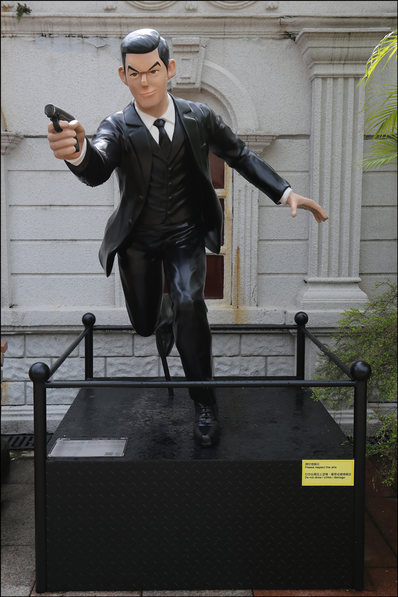
K was drawn by artist Li Chi-tat as a character in the comic K. In the comic, K is a Chinese agent (similar to James Bond) who is with a loose attitude toward romance and heroic characteristics.
K SOURCE: K (Kowloon Park, Yau Tsim Mong District, Hong Kong Special Administrative Region of the People’s Republic of China); photographed by Stephen J. Danko on 16 April 2019.
Liaoyuan Huo was drawn by artist Chan Mou as a character in the comic The Ravages of Time. In the comic, Liaoyuan Huo, the chief of the mercenary assissins “Handicapped Warriors,” becomes the most invincible warrior of the time.
Liaoyuan Huo SOURCE: Liaoyuan Huo (Kowloon Park, Yau Tsim Mong District, Hong Kong Special Administrative Region of the People’s Republic of China); photographed by Stephen J. Danko on 16 April 2019.
Guo Jing was drawn by artist Lee Chi-ching as a character in the comic The Legend of the Condor Heroes. In the comic, Guo Jing exhibit orthodox moral values and traditional chivalry.
Guo Jing SOURCE: Guo Jing (Kowloon Park, Yau Tsim Mong District, Hong Kong Special Administrative Region of the People’s Republic of China); photographed by Stephen J. Danko on 16 April 2019.
Nan Gong Wen Tian was drawn by artist Wong Yuk-long (Tony) as a character in the comic Magical Weapons. In the comic, Nan Gong Wen Tian defends the Nan Gong Clan with the weapon known as Heaven’s Crystal.
Nan Gong Wen Tian SOURCE: Nan Gong Wen Tian (Kowloon Park, Yau Tsim Mong District, Hong Kong Special Administrative Region of the People’s Republic of China); photographed by Stephen J. Danko on 16 April 2019.
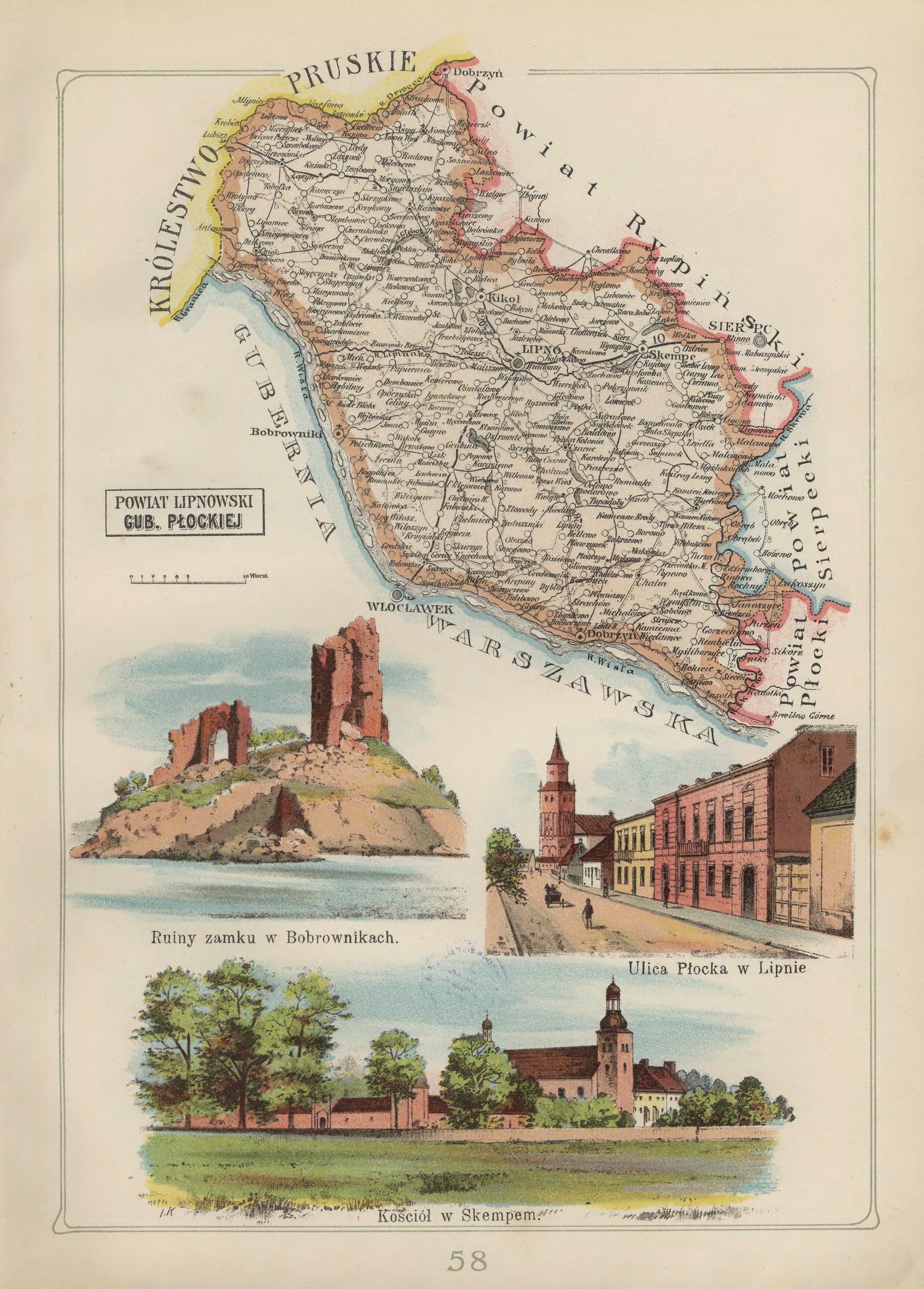
Lipno Powiat in the Płock Gubernia – 1907 Józef Michał Bazewicz, Atlas geograficzny ilustrowany Królestwa Polskiego (Litografia B. A. Bukaty, Warsaw, 1907); digital images, Mapywig (http://igrek.amzp.pl/details.php?id=11767109 : accessed 02 March 2019).
The administrative structure of the parishes of Bobrowniki, Czarne, Dobrzyń nad Wisłą, Grochowalsk, Karnkowo, Kikół, Lipno, Mazowsze, Mokowo, Skępe, Sumin, Tłuchowo, Wielgie, Wola, and Zaduszniki can be described as follows:
01 Jul 1569-22 Jan 1793: Village, Inowrocław Voivodeship, Crown of the Kingdom of Poland, Polish-Lithuanian Commonwealth
23 Jan 1793-04 Oct 1795: Village, Province of South Prussia, Kingdom of Prussia
04 Oct 1795-08 Jul 1807: Village, Lipno Powiat, Kammerdepartement Płock, Province of New East Prussia, Kingdom of Prussia
09 Jul 1807-08 Jun 1815: Village, Lipno Powiat, Płock Department, Duchy of Warsaw
09 Jun 1815-15 Jan 1816: Village, Lipno Powiat, Płock Department, Congress Kingdom of Poland
16 Jan 1816-06 Mar 1837: Village, Lipno Obwód, Płock Voivodeship, Congress Kingdom of Poland
07 Mar 1837-10 Nov 1842: Village, Lipno Obwód, Płock Gubernia, Congress Kingdom of Poland
11 Nov 1842-30 Dec 1866: Village, Lipno Powiat, Płock Gubernia, Congress Kingdom of Poland
31 Dec 1866-07 Sep 1915: Village, Lipno Powiat, Płock Gubernia, Congress Kingdom of Poland
08 Sep 1915-10 Nov 1918: Village, Lipno Powiat, General Government of Warsaw, German Empire
11 Nov 1918-31 Mar 1938: Village, Lipno Powiat, Warsaw Voivodeship, Second Polish Republic
01 Apr 1938-07 Oct 1939: Village, Lipno Powiat, Pomeranian Voivodeship, Second Polish Republic
08 Oct 1939-27 Jun 1945: Village, Kreis Leipe, Regierungsbezirk Marienwerder, Reichsgau Danzig-West Prussia, German Reich
28 Jun 1945-21 Jul 1952: Village, Rypin Powiat, Bydgoszcz Voivodeship, Republic of Poland
22 Jul 1952-31 May 1975: Village, Rypin Powiat, Bydgoszcz Voivodeship, Polish People’s Republic
01 Jun 1975-30 Dec 1989: Village, Włocławek Voivodeship, Polish People’s Republic
31 Dec 1989-30 Dec 1998: Village, Włocławek Voivodeship, Third Polish Republic
31 Dec 1998-Present: Village, Lipno Powiat, Kuyavian-Pomeranian Voivodeship, Third Polish Republic
The administrative structure of the parishes of Dobrzejewice, Osiek nad Wisłą, and Skrzypkowo can be described as follows:
01 Jul 1569-22 Jan 1793: Village, Inowrocław Voivodeship, Crown of the Kingdom of Poland, Polish-Lithuanian Commonwealth
23 Jan 1793-04 Oct 1795: Village, Province of South Prussia, Kingdom of Prussia
04 Oct 1795-08 Jul 1807: Village, Lipno Powiat, Kammerdepartement Płock, Province of New East Prussia, Kingdom of Prussia
09 Jul 1807-08 Jun 1815: Village, Lipno Powiat, Płock Department, Duchy of Warsaw
09 Jun 1815-15 Jan 1816: Village, Lipno Powiat, Płock Department, Congress Kingdom of Poland
16 Jan 1816-06 Mar 1837: Village, Lipno Obwód, Płock Voivodeship, Congress Kingdom of Poland
07 Mar 1837-10 Nov 1842: Village, Lipno Obwód, Płock Gubernia, Congress Kingdom of Poland
11 Nov 1842-30 Dec 1866: Village, Lipno Powiat, Płock Gubernia, Congress Kingdom of Poland
31 Dec 1866-07 Sep 1915: Village, Lipno Powiat, Płock Gubernia, Congress Kingdom of Poland
08 Sep 1915-10 Nov 1918: Village, Lipno Powiat, General Government of Warsaw, German Empire
11 Nov 1918-31 Mar 1938: Village, Lipno Powiat, Warsaw Voivodeship, Second Polish Republic
01 Apr 1938-07 Oct 1939: Village, Lipno Powiat, Pomeranian Voivodeship, Second Polish Republic
08 Oct 1939-27 Jun 1945: Village, Kreis Leipe, Regierungsbezirk Marienwerder, Reichsgau Danzig-West Prussia, German Reich
28 Jun 1945-21 Jul 1952: Village, Rypin Powiat, Bydgoszcz Voivodeship, Republic of Poland
22 Jul 1952-31 May 1975: Village, Rypin Powiat, Bydgoszcz Voivodeship, Polish People’s Republic
01 Jun 1975-30 Dec 1989: Village, Toruń Voivodeship, Polish People’s Republic
31 Dec 1989-30 Dec 1998: Village, Toruń Voivodeship, Third Polish Republic
31 Dec 1998-Present: Village, Toruń Powiat, Kuyavian-Pomeranian Voivodeship, Third Polish Republic
The administrative structure of the parish of Czernikowo can be described as follows:
01 Jul 1569-22 Jan 1793: Village, Inowrocław Voivodeship, Crown of the Kingdom of Poland, Polish-Lithuanian Commonwealth
23 Jan 1793-04 Oct 1795: Village, Province of South Prussia, Kingdom of Prussia
04 Oct 1795-08 Jul 1807: Village, Lipno Powiat, Kammerdepartement Płock, Province of New East Prussia, Kingdom of Prussia
09 Jul 1807-08 Jun 1815: Village, Lipno Powiat, Płock Department, Duchy of Warsaw
09 Jun 1815-15 Jan 1816: Village, Lipno Powiat, Płock Department, Congress Kingdom of Poland
16 Jan 1816-06 Mar 1837: Village, Lipno Obwód, Płock Voivodeship, Congress Kingdom of Poland
07 Mar 1837-10 Nov 1842: Village, Lipno Obwód, Płock Gubernia, Congress Kingdom of Poland
11 Nov 1842-30 Dec 1866: Village, Lipno Powiat, Płock Gubernia, Congress Kingdom of Poland
31 Dec 1866-07 Sep 1915: Village, Lipno Powiat, Płock Gubernia, Congress Kingdom of Poland
08 Sep 1915-10 Nov 1918: Village, Lipno Powiat, General Government of Warsaw, German Empire
11 Nov 1918-31 Mar 1938: Village, Lipno Powiat, Warsaw Voivodeship, Second Polish Republic
01 Apr 1938-07 Oct 1939: Village, Lipno Powiat, Pomeranian Voivodeship, Second Polish Republic
08 Oct 1939-27 Jun 1945: Village, Kreis Leipe, Regierungsbezirk Marienwerder, Reichsgau Danzig-West Prussia, German Reich
28 Jun 1945-21 Jul 1952: Village, Rypin Powiat, Bydgoszcz Voivodeship, Republic of Poland
22 Jul 1952-31 May 1975: Village, Rypin Powiat, Bydgoszcz Voivodeship, Polish People’s Republic
01 Jun 1975-30 Dec 1989: Village, Włocławek Voivodeship, Polish People’s Republic
31 Dec 1989-30 Dec 1998: Village, Włocławek Voivodeship, Third Polish Republic
31 Dec 1998-Present: Village, Toruń Powiat, Kuyavian-Pomeranian Voivodeship, Third Polish Republic
The administrative structure of the parish of Chełmica Duża can be described as follows:
01 Jul 1569-22 Jan 1793: Village, Inowrocław Voivodeship, Crown of the Kingdom of Poland, Polish-Lithuanian Commonwealth
23 Jan 1793-04 Oct 1795: Village, Province of South Prussia, Kingdom of Prussia
04 Oct 1795-08 Jul 1807: Village, Lipno Powiat, Kammerdepartement Płock, Province of New East Prussia, Kingdom of Prussia
09 Jul 1807-08 Jun 1815: Village, Lipno Powiat, Płock Department, Duchy of Warsaw
09 Jun 1815-15 Jan 1816: Village, Lipno Powiat, Płock Department, Congress Kingdom of Poland
16 Jan 1816-06 Mar 1837: Village, Lipno Obwód, Płock Voivodeship, Congress Kingdom of Poland
07 Mar 1837-10 Nov 1842: Village, Lipno Obwód, Płock Gubernia, Congress Kingdom of Poland
11 Nov 1842-30 Dec 1866: Village, Lipno Powiat, Płock Gubernia, Congress Kingdom of Poland
31 Dec 1866-07 Sep 1915: Village, Lipno Powiat, Płock Gubernia, Congress Kingdom of Poland
08 Sep 1915-10 Nov 1918: Village, Lipno Powiat, General Government of Warsaw, German Empire
11 Nov 1918-31 Mar 1938: Village, Lipno Powiat, Warsaw Voivodeship, Second Polish Republic
01 Apr 1938-07 Oct 1939: Village, Lipno Powiat, Pomeranian Voivodeship, Second Polish Republic
08 Oct 1939-27 Jun 1945: Village, Kreis Leipe, Regierungsbezirk Marienwerder, Reichsgau Danzig-West Prussia, German Reich
28 Jun 1945-21 Jul 1952: Village, Rypin Powiat, Bydgoszcz Voivodeship, Republic of Poland
22 Jul 1952-31 May 1975: Village, Rypin Powiat, Bydgoszcz Voivodeship, Polish People’s Republic
01 Jun 1975-30 Dec 1989: Village, Włocławek Voivodeship, Polish People’s Republic
31 Dec 1989-30 Dec 1998: Village, Włocławek Voivodeship, Third Polish Republic
31 Dec 1998-Present: Village, Włocławek Powiat, Kuyavian-Pomeranian Voivodeship, Third Polish Republic
The administrative structure of the parishes of Ciechocin, Nowogród, and Ostrowite can be described as follows:
01 Jul 1569-22 Jan 1793: Village, Inowrocław Voivodeship, Crown of the Kingdom of Poland, Polish-Lithuanian Commonwealth
23 Jan 1793-04 Oct 1795: Village, Province of South Prussia, Kingdom of Prussia
04 Oct 1795-08 Jul 1807: Village, Lipno Powiat, Kammerdepartement Płock, Province of New East Prussia, Kingdom of Prussia
09 Jul 1807-08 Jun 1815: Village, Lipno Powiat, Płock Department, Duchy of Warsaw
09 Jun 1815-15 Jan 1816: Village, Lipno Powiat, Płock Department, Congress Kingdom of Poland
16 Jan 1816-06 Mar 1837: Village, Lipno Obwód, Płock Voivodeship, Congress Kingdom of Poland
07 Mar 1837-10 Nov 1842: Village, Lipno Obwód, Płock Gubernia, Congress Kingdom of Poland
11 Nov 1842-30 Dec 1866: Village, Lipno Powiat, Płock Gubernia, Congress Kingdom of Poland
31 Dec 1866-07 Sep 1915: Village, Lipno Powiat, Płock Gubernia, Congress Kingdom of Poland
08 Sep 1915-10 Nov 1918: Village, Lipno Powiat, General Government of Warsaw, German Empire
11 Nov 1918-31 Mar 1938: Village, Lipno Powiat, Warsaw Voivodeship, Second Polish Republic
01 Apr 1938-07 Oct 1939: Village, Lipno Powiat, Pomeranian Voivodeship, Second Polish Republic
08 Oct 1939-27 Jun 1945: Village, Kreis Leipe, Regierungsbezirk Marienwerder, Reichsgau Danzig-West Prussia, German Reich
28 Jun 1945-21 Jul 1952: Village, Rypin Powiat, Bydgoszcz Voivodeship, Republic of Poland
22 Jul 1952-31 May 1975: Village, Rypin Powiat, Bydgoszcz Voivodeship, Polish People’s Republic
01 Jun 1975-30 Dec 1989: Village, Toruń Voivodeship, Polish People’s Republic
31 Dec 1989-30 Dec 1998: Village, Toruń Voivodeship, Third Polish Republic
31 Dec 1998-Present: Village, Golub-Dobrzyń Powiat, Kuyavian-Pomeranian Voivodeship, Third Polish Republic
The administrative structure of the parish of Działyń can be described as follows:
01 Jul 1569-22 Jan 1793: Village, Inowrocław Voivodeship, Crown of the Kingdom of Poland, Polish-Lithuanian Commonwealth
23 Jan 1793-04 Oct 1795: Village, Province of South Prussia, Kingdom of Prussia
04 Oct 1795-08 Jul 1807: Village, Lipno Powiat, Kammerdepartement Płock, Province of New East Prussia, Kingdom of Prussia
09 Jul 1807-08 Jun 1815: Village, Lipno Powiat, Płock Department, Duchy of Warsaw
09 Jun 1815-15 Jan 1816: Village, Lipno Powiat, Płock Department, Congress Kingdom of Poland
16 Jan 1816-06 Mar 1837: Village, Lipno Obwód, Płock Voivodeship, Congress Kingdom of Poland
07 Mar 1837-10 Nov 1842: Village, Lipno Obwód, Płock Gubernia, Congress Kingdom of Poland
11 Nov 1842-30 Dec 1866: Village, Lipno Powiat, Płock Gubernia, Congress Kingdom of Poland
31 Dec 1866-07 Sep 1915: Village, Lipno Powiat, Płock Gubernia, Congress Kingdom of Poland
08 Sep 1915-10 Nov 1918: Village, Lipno Powiat, General Government of Warsaw, German Empire
11 Nov 1918-31 Mar 1938: Village, Lipno Powiat, Warsaw Voivodeship, Second Polish Republic
01 Apr 1938-07 Oct 1939: Village, Lipno Powiat, Pomeranian Voivodeship, Second Polish Republic
08 Oct 1939-27 Jun 1945: Village, Kreis Leipe, Regierungsbezirk Marienwerder, Reichsgau Danzig-West Prussia, German Reich
28 Jun 1945-21 Jul 1952: Village, Rypin Powiat, Bydgoszcz Voivodeship, Republic of Poland
22 Jul 1952-31 May 1975: Village, Rypin Powiat, Bydgoszcz Voivodeship, Polish People’s Republic
01 Jun 1975-30 Dec 1989: Village, Włocławek Voivodeship, Polish People’s Republic
31 Dec 1989-30 Dec 1998: Village, Włocławek Voivodeship, Third Polish Republic
31 Dec 1998-Present: Village, Golub-Dobrzyń Powiat, Kuyavian-Pomeranian Voivodeship, Third Polish Republic
The administrative structure of the parishes of Bądkowo Kościelne, Rokicie, Sobowo, and Siecień can be described as follows:
01 Jul 1569-22 Jan 1793: Village, Inowrocław Voivodeship, Crown of the Kingdom of Poland, Polish-Lithuanian Commonwealth
23 Jan 1793-04 Oct 1795: Village, Province of South Prussia, Kingdom of Prussia
04 Oct 1795-08 Jul 1807: Village, Lipno Powiat, Kammerdepartement Płock, Province of New East Prussia, Kingdom of Prussia
09 Jul 1807-08 Jun 1815: Village, Lipno Powiat, Płock Department, Duchy of Warsaw
09 Jun 1815-15 Jan 1816: Village, Lipno Powiat, Płock Department, Congress Kingdom of Poland
16 Jan 1816-06 Mar 1837: Village, Lipno Obwód, Płock Voivodeship, Congress Kingdom of Poland
07 Mar 1837-10 Nov 1842: Village, Lipno Obwód, Płock Gubernia, Congress Kingdom of Poland
11 Nov 1842-30 Dec 1866: Village, Lipno Powiat, Płock Gubernia, Congress Kingdom of Poland
31 Dec 1866-07 Sep 1915: Village, Lipno Powiat, Płock Gubernia, Congress Kingdom of Poland
08 Sep 1915-10 Nov 1918: Village, Lipno Powiat, General Government of Warsaw, German Empire
11 Nov 1918-31 Mar 1938: Village, Lipno Powiat, Warsaw Voivodeship, Second Polish Republic
01 Apr 1938-07 Oct 1939: Village, Lipno Powiat, Pomeranian Voivodeship, Second Polish Republic
08 Oct 1939-27 Jun 1945: Village, Kreis Leipe, Regierungsbezirk Marienwerder, Reichsgau Danzig-West Prussia, German Reich
28 Jun 1945-21 Jul 1952: Village, Rypin Powiat, Bydgoszcz Voivodeship, Republic of Poland
22 Jul 1952-31 May 1975: Village, Rypin Powiat, Bydgoszcz Voivodeship, Polish People’s Republic
01 Jun 1975-30 Dec 1989: Village, Płock Voivodeship, Polish People’s Republic
31 Dec 1989-30 Dec 1998: Village, Płock Voivodeship, Third Polish Republic
31 Dec 1998-Present: Village, Płock Powiat, Masovian Voivodeship, Third Polish Republic
The administrative structure of the parish of Ligowo can be described as follows:
01 Jul 1569-22 Jan 1793: Village, Inowrocław Voivodeship, Crown of the Kingdom of Poland, Polish-Lithuanian Commonwealth
23 Jan 1793-04 Oct 1795: Village, Province of South Prussia, Kingdom of Prussia
04 Oct 1795-08 Jul 1807: Village, Lipno Powiat, Kammerdepartement Płock, Province of New East Prussia, Kingdom of Prussia
09 Jul 1807-08 Jun 1815: Village, Lipno Powiat, Płock Department, Duchy of Warsaw
09 Jun 1815-15 Jan 1816: Village, Lipno Powiat, Płock Department, Congress Kingdom of Poland
16 Jan 1816-06 Mar 1837: Village, Lipno Obwód, Płock Voivodeship, Congress Kingdom of Poland
07 Mar 1837-10 Nov 1842: Village, Lipno Obwód, Płock Gubernia, Congress Kingdom of Poland
11 Nov 1842-30 Dec 1866: Village, Lipno Powiat, Płock Gubernia, Congress Kingdom of Poland
31 Dec 1866-07 Sep 1915: Village, Lipno Powiat, Płock Gubernia, Congress Kingdom of Poland
08 Sep 1915-10 Nov 1918: Village, Lipno Powiat, General Government of Warsaw, German Empire
11 Nov 1918-31 Mar 1938: Village, Lipno Powiat, Warsaw Voivodeship, Second Polish Republic
01 Apr 1938-07 Oct 1939: Village, Lipno Powiat, Pomeranian Voivodeship, Second Polish Republic
08 Oct 1939-27 Jun 1945: Village, Kreis Leipe, Regierungsbezirk Marienwerder, Reichsgau Danzig-West Prussia, German Reich
28 Jun 1945-21 Jul 1952: Village, Rypin Powiat, Bydgoszcz Voivodeship, Republic of Poland
22 Jul 1952-31 May 1975: Village, Rypin Powiat, Bydgoszcz Voivodeship, Polish People’s Republic
01 Jun 1975-30 Dec 1989: Village, Płock Voivodeship, Polish People’s Republic
31 Dec 1989-30 Dec 1998: Village, Płock Voivodeship, Third Polish Republic
31 Dec 1998-Present: Village, Sierpc Powiat, Masovian Voivodeship, Third Polish Republic
The Crown of the Kingdom of Poland refers to the territories under the control of the King of Poland. The Union of Lublin, signed on 01 July 1569, joined the Crown of the Kingdom of Poland to the Grand Duchy of Lithuania. The Union of Lublin transferred the Poldaskie, Volhynian (Wołyń), Podole, and Kiev (Kijów) Voivodeships from the Grand Duchy of Lithuania to the Crown of the Kingdom of Poland.
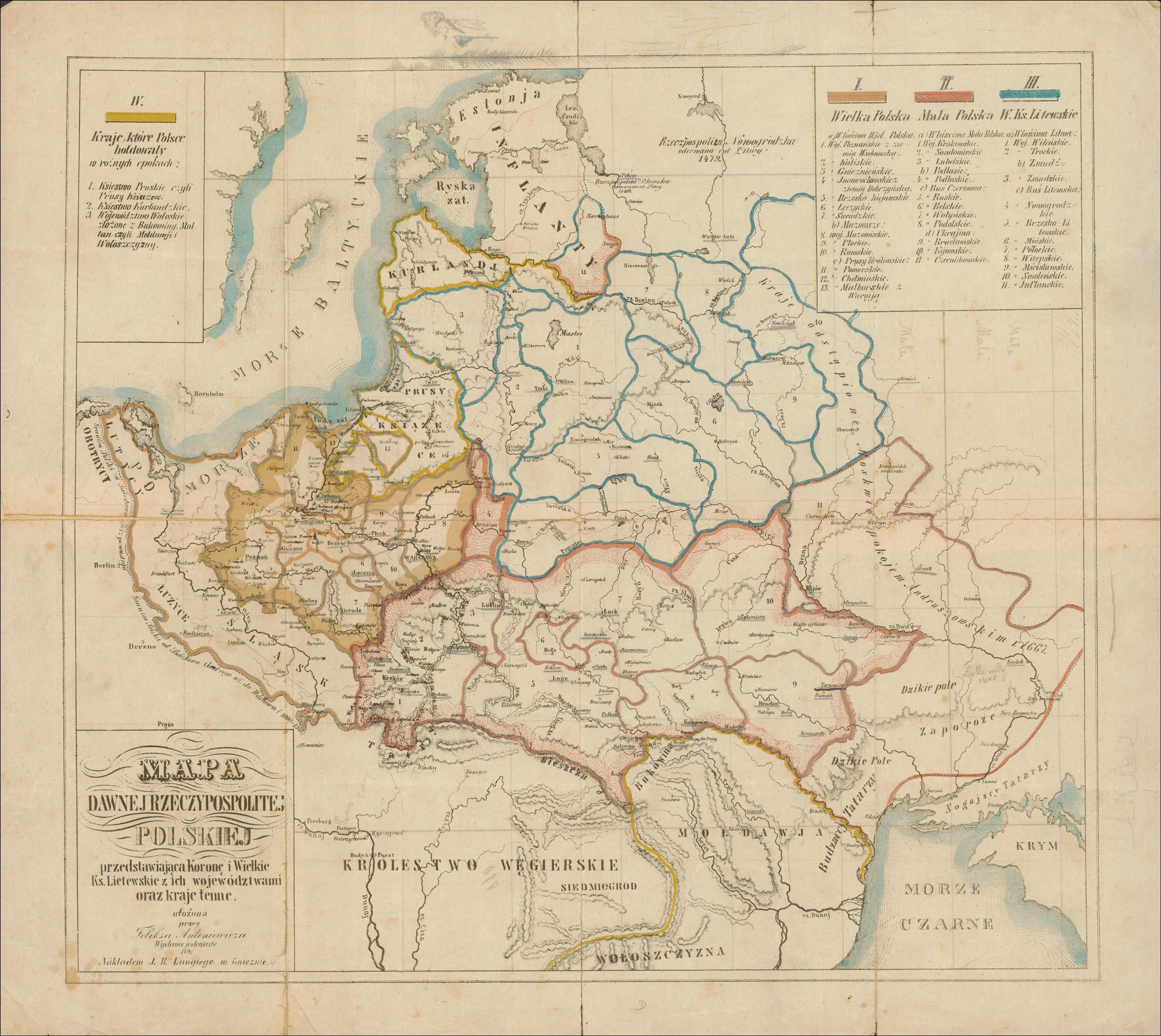
Polish-Lithuanian Commonwealth – After 1667 Feliks Antoniewicz, Mapa dawnej Rzeczypospolitej Polskiej (Jan Bernard Lange, Gniezno, 1891); digital images, Polona Digital Library (http://polona.pl/item/67740800/ : accessed 17 March 2019).
The territories of the Crown of the Kingdom of Poland were divided into the Greater Poland Province (Wielkopolska) and the Lesser Poland Province (Małopolska).
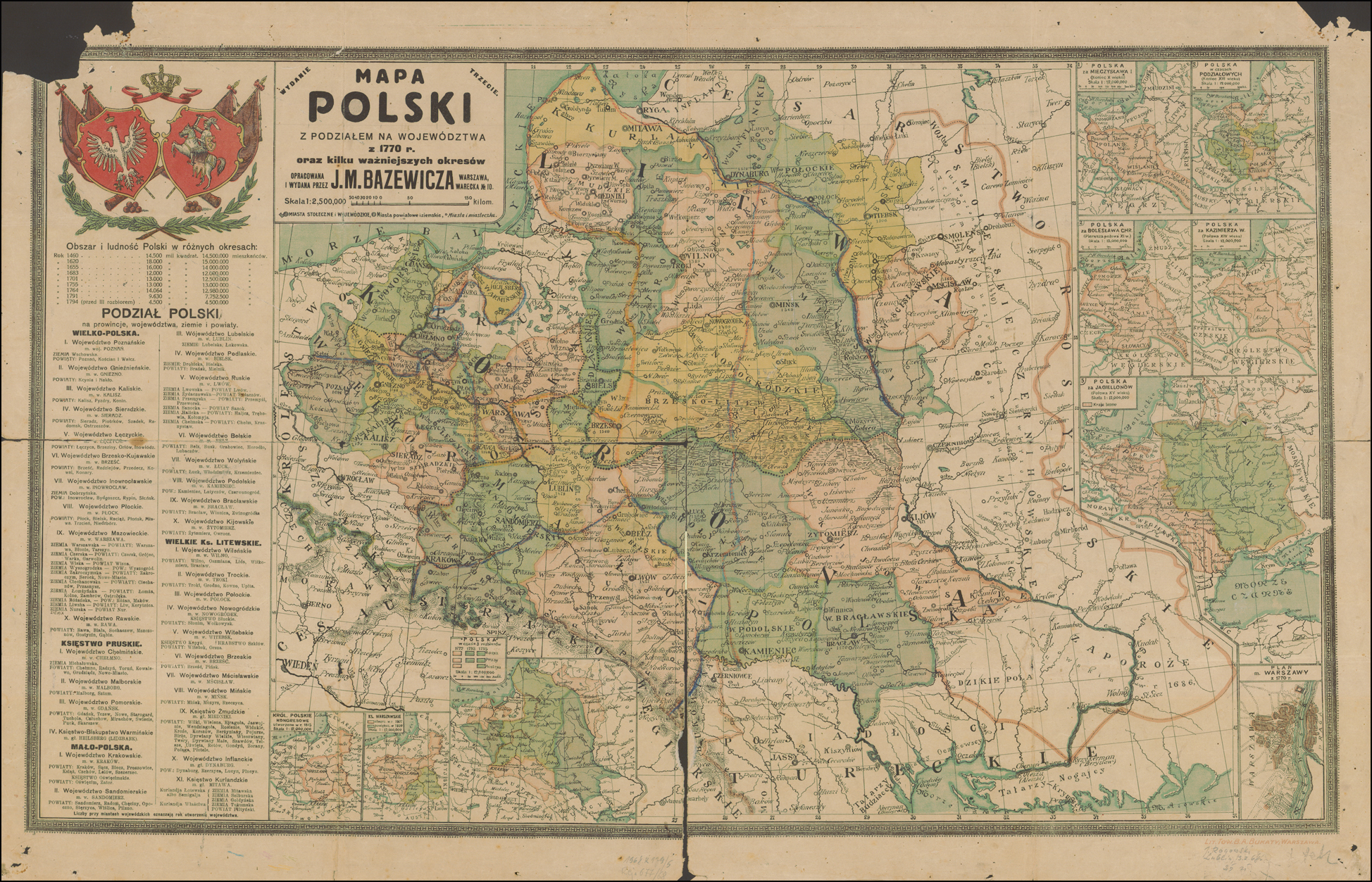
Polish-Lithuanian Commonwealth – 1770 J. M. Bazewicz, Mapa Polski z podziałem na województwa z 1770 rok oraz kilku ważniejszych okresów (Lit. Tow. B. A. Bukaty, Warsaw, before 1918); digital images, Polona Digital Library (http://polona.pl/item/67739482/ : accessed 17 March 2019).
Greater Poland Province (Wielkopolska) Greater Poland Proper
Brześć Kujawski Voivodeship (Powaits: Brzesc, Kowal, Kruszwica, Przedecz, and Radziejów)
Gniezno Voivodeship (Powiats: Gniezno, Kcynia, and Naklo); created from Kalisz Voivodeship in 1768
Inowrocław Voivodeship (Powiats: Bydgoszcz and Inowrocław)
Dobrzyń Ziemia (Powiats: Dobrzyń, Rypin, and Lipno)
Kalisz Voivodeship (Powiats: Gniezno, Kalisz, Kcynia, Konin, Nakło, and Pyzdry); in 1768, powiats Gniezno, Kcynia, and Nakło were transferred to the Gniezno Voivodeship, resulting in (Powiats: Kalisz, Konin, and Pyzdry)
Łęczyca Voivodeship (Powiats: Łęczyca, Brzeziny, and Orłów); an administrative restructuring in 1791 resulted in (Powiats: Inowłodz, Łęczyca, Brzeziny, and Orłów)
Poznań Voivodeship (Powiats: Poznań, Kościan, and Wałcz)
Wschowa Ziemia (Powiat: Wschowa)
Sieradz Voivodeship (Powiats: Piotrków, Radomsko, Sieradz, and Szadek)
Wieluń Ziemia (Powiats; Ostrzeszów and Wieluń)
Greater Poland Province (Wielkopolska) Mazovia
Mazovian Voivodeship
Ciechanów Ziemia (Powiats: Ciechanów, Przasnysz, and Sąchocin)
Czersk Ziema (Powiats: Czersk [sometimes called Garwolin], Grójec, and Warka)
Liw Ziemia (Powiat: Liw)
Łomża Ziemia (Powiats: Kolno, Łomża, Ostrołęka, and Zambrów)
Nur Ziemia (Powiat: Kamieńczyk, Nur, and Ostrów)
Różan Ziemia (Powiats: Różan and Maków)
Warsaw Ziemia (Powiats: Błonie, Tarczyn, and Warsaw)
Wiska Ziemia (Powiats: Radziłów, Wąsosz, and Wizna)
Wyszogród Ziemia (Powiat: Wyszogród)
Zakroczym Ziemia (Powiats: Nowe Miasto and Zakroczym)
Płock Voivodeship
Płock Ziemia (Powiats: Bielsk, Płock, Płońsk, Raciąż, and Sierpc)
Zawkrze Ziemia (Powiats Mława, Niedzbórz, and Szreńsk)
Rawa Voivodeship
Rawa Ziemia (Powiats: Biała and Rawa)
Gostynin Ziemia (Powiats: Gąbin and Gostynin)
Sochaczew Ziemia (Powiats: Mszczonów and Sochaczew)
Greater Poland Province (Wielkopolska) Royal Prussia
Chełmno Voivodeship (Powiats: Chełmno and Michałów); an administrative restructuring in 1764 resulted in:
Chełmno Ziemia (Powiats: Chełmno, Grudziądz, Kowalewo, Radzyń, and Toruń)
Michałowo Ziemia (Powiats: Brodnica and Nowe Miasto)
Malbork Voivodeship (Powiats: Elbląg, Kiszpork [also known as Dziergoń], Malbork, and Sztum)
Prince-Bishopric of Warmia
Pomeranian Voivodeship (Powiats: Człuchów, Gdańsk, Mirachów, Nowe, Puck, Świecie, Tczew, and Tuchola); an administrative restructuring in 1764 resulted in (Powiats: Człuchów, Gdańsk, Kościerzyna, Mirachów, Nowe, Puck, Skarszewy, Świecie, Tczew, and Tuchola)
Lesser Poland Province (Małopolska) Lesser Poland Proper
Kraków Voivodeship (Powiats: Biecz, Książ, Lelów, Sądek, Śląsk, Proszowice, and Szczyrzyc); in 1676 the administrative division included (Powiats: Biecz, Czchów, Kraków, Książ, Lelów, Sądek, Proszowice, and Szczyrzyc)
Duchy of Oświęcim and Zator (Powiats: Oświęcim and Zator)
Lublin Voivodeship (Powiats: Lublin and Urzędów)
Łuków Ziemia (Powiat: Łuków)
Sandomierz Voivodeship
Radom Ziemia (Powiats: Chęciny, Opoczno, and Radom)
Sandomierz Ziemia (Powiats: Pilzno, Sandomierz, and Wiślica)
Stężyca Ziemia (Powiat: Stężyca)
Lesser Poland Province (Małopolska) Podlaskie
Podlaskie Voivodeship
Bielsk Ziemia (Powiats: Brańsk, Tykocin, and Suraż)
Drohiczyn Ziemia
Mielnik Ziemia
Lesser Poland Province (Małopolska) Ruthenia
Bełz Voivodeship (Powiats: Belz, Grabowiec, Horodło, and Lubaczów)
Busk Ziemia (Powiat: Busk)
Podole Voivodeship (Powiats: Czerwonogród, Kamieniec, and Latyczów)
Ruthenian Voivodeship
Chełm Ziemia (Powiats: Chełm and Krasnystaw)
Halicz Ziemia (Powiats: Halicz, Kołomyja, and Trembowla)
Lwów Ziemia (Powiat: Lwów)
Przemyśl Ziemia (Powiats: Przemyśl and Przeworsk)
Sanok Ziemia (Powiat: Sanok)
Żydaczów Ziemia (Powiat: Żydaczów) sometimes part of Lwów Ziemia
Volhynian Voivodeship (Powiats: Krzemieniec, Łuck, and Włodzimierz)
Lesser Poland Province (Małopolska) Ukraine
Bracław Voivodeship (Powiats: Bracław, Winnicki, and Zwinogródka) an administrative restructuring in 1791 resulted in (Powiats: Bracław, Nadboh, Winnicki, and Zwinogródka)
Czernichów Voivodeship (Powiats: Chernihów and Nowogród) created in 1635, lost to Russia on 09 February 1667
Kijów Voivodeship (Powiats: Kijów, Owrucz, and Żytomierz) Kijów Powiat lost to Russia on 09 February 1667 resulting in (Powiats: Owrucz, and Żytomierz)
REFERENCES
Gloger, Zygmunt. 1900. Geografia historyczna ziem dawnej Polski. Warszawa: Spółka Wydawnicza Polska. Image copy. Wielkopolska Biblioteka Cyfrowa (http://www.wbc.poznan.pl/dlibra/docmetadata?id=3149 : 2019).
Gloger, Zygmunt. 1991. Geografia historyczna ziem dawnej Polski. Warszawa: Wydawn. Wiedza Powszechna. Summary. Biblioteka Literatury Polskiej w Internecie (http://literat.ug.edu.pl/glogre/ : 2019)
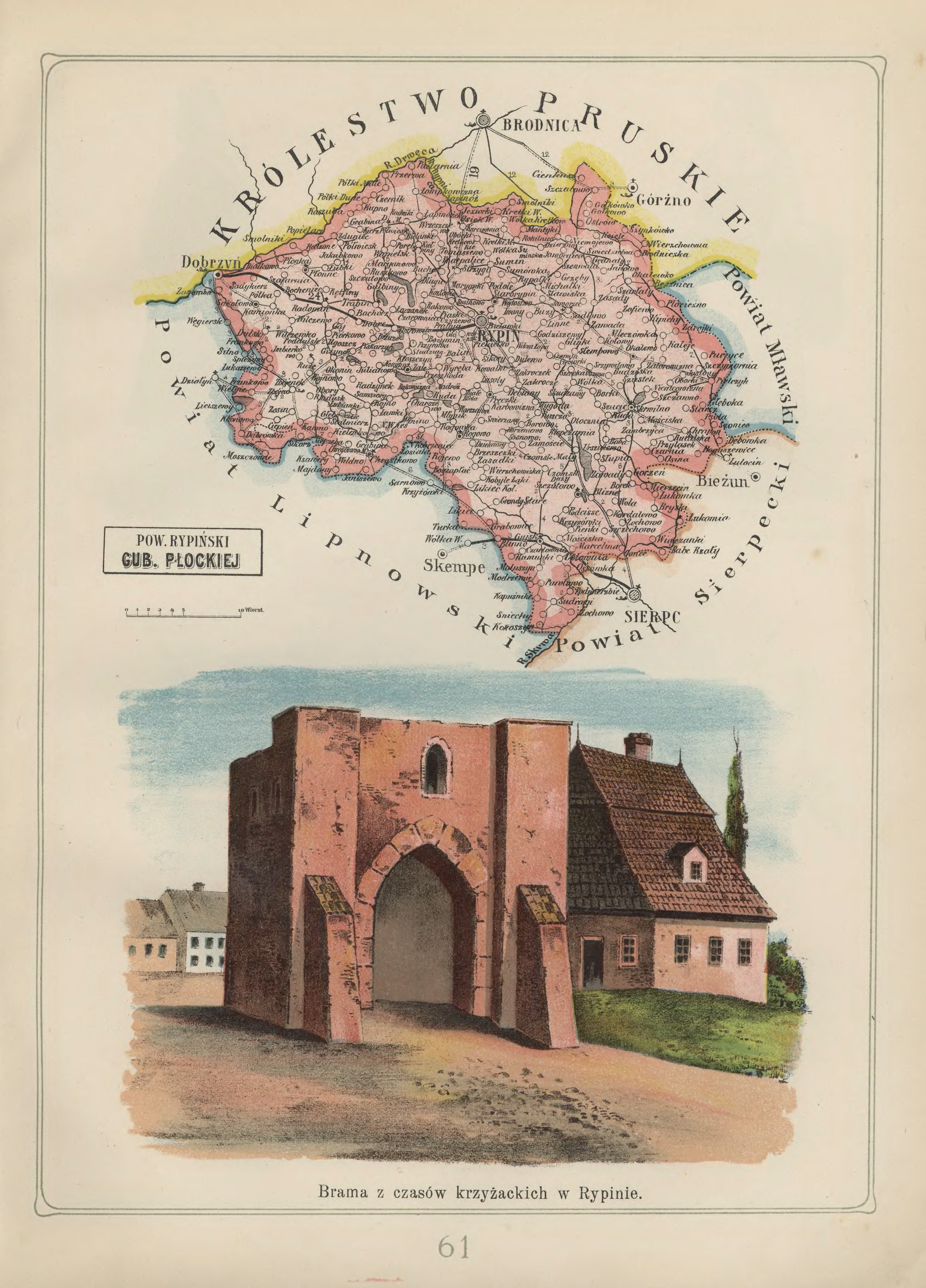
Rypin Powiat in the Płock Gubernia – 1907 Józef Michał Bazewicz, Atlas geograficzny ilustrowany Królestwa Polskiego (Litografia B. A. Bukaty, Warsaw, 1907); digital images, Mapywig (http://igrek.amzp.pl/details.php?id=11767112 : accessed 02 February 2019).
The administrative structure of the parish of Chrostkowo can be described as follows:
01 Jul 1569-22 Jan 1793: Village, Inowrocław Voivodeship, Crown of the Kingdom of Poland, Polish-Lithuanian Commonwealth
23 Jan 1793-04 Oct 1795: Village, Province of South Prussia, Kingdom of Prussia
04 Oct 1795-08 Jul 1807: Village, Lipno Powiat, Kammerdepartement Płock, Province of New East Prussia, Kingdom of Prussia
09 Jul 1807-08 Jun 1815: Village, Lipno Powiat, Płock Department, Duchy of Warsaw
09 Jun 1815-15 Jan 1816: Village, Lipno Powiat, Płock Department, Congress Kingdom of Poland
16 Jan 1816-06 Mar 1837: Village, Lipno Obwód, Płock Voivodeship, Congress Kingdom of Poland
07 Mar 1837-10 Nov 1842: Village, Lipno Obwód, Płock Gubernia, Congress Kingdom of Poland
11 Nov 1842-30 Dec 1866: Village, Lipno Powiat, Płock Gubernia, Congress Kingdom of Poland
31 Dec 1866-18 Oct 1915: Village, Rypin Powiat, Płock Gubernia, Congress Kingdom of Poland
18 Oct 1915-10 Nov 1918: Village, Lipno Powiat, General Government of Warsaw, German Empire
11 Nov 1918-31 Mar 1938: Village, Rypin Powiat, Warsaw Voivodeship, Second Polish Republic
01 Apr 1938-07 Oct 1939: Village, Rypin Powiat, Pomeranian Voivodeship, Second Polish Republic
08 Oct 1939-27 Jun 1945: Village, Landkreis Rippin, Regierungsbezirk Marienwerder, Reichsgau Danzig-West Prussia, German Reich
28 Jun 1945-21 Jul 1952: Village, Rypin Powiat, Bydgoszcz Voivodeship, Republic of Poland
22 Jul 1952-31 May 1975: Village, Rypin Powiat, Bydgoszcz Voivodeship, Polish People’s Republic
01 Jun 1975-30 Dec 1989: Village, Włocławek Voivodeship, Polish People’s Republic
31 Dec 1989-30 Dec 1998: Village, Włocławek Voivodeship, Third Polish Republic
31 Dec 1998-Present: Village, Lipno Powiat, Kuyavian-Pomeranian Voivodeship, Third Polish Republic
The administrative structure of the parishes of Michałki, Osiek, Sumin, and Świedziebnia can be described as follows:
01 Jul 1569-22 Jan 1793: Village, Inowrocław Voivodeship, Crown of the Kingdom of Poland, Polish-Lithuanian Commonwealth
23 Jan 1793-04 Oct 1795: Village, Province of South Prussia, Kingdom of Prussia
04 Oct 1795-08 Jul 1807: Village, Lipno Powiat, Kammerdepartement Płock, Province of New East Prussia, Kingdom of Prussia
09 Jul 1807-08 Jun 1815: Village, Lipno Powiat, Płock Department, Duchy of Warsaw
09 Jun 1815-15 Jan 1816: Village, Lipno Powiat, Płock Department, Congress Kingdom of Poland
16 Jan 1816-06 Mar 1837: Village, Lipno Obwód, Płock Voivodeship, Congress Kingdom of Poland
07 Mar 1837-10 Nov 1842: Village, Lipno Obwód, Płock Gubernia, Congress Kingdom of Poland
11 Nov 1842-30 Dec 1866: Village, Lipno Powiat, Płock Gubernia, Congress Kingdom of Poland
31 Dec 1866-18 Oct 1915: Village, Rypin Powiat, Płock Gubernia, Congress Kingdom of Poland
18 Oct 1915-10 Nov 1918: Village, Lipno Powiat, General Government of Warsaw, German Empire
11 Nov 1918-31 Mar 1938: Village, Rypin Powiat, Warsaw Voivodeship, Second Polish Republic
01 Apr 1938-31 Aug 1939: Village, Rypin Powiat, Pomeranian Voivodeship, Second Polish Republic
08 Oct 1939-27 Jun 1945: Village, Landkreis Rippin, Regierungsbezirk Marienwerder, Reichsgau Danzig-West Prussia, German Reich
28 Jun 1945-21 Jul 1952: Village, Rypin Powiat, Bydgoszcz Voivodeship, Republic of Poland
22 Jul 1952-31 May 1975: Village, Rypin Powiat, Bydgoszcz Voivodeship, Polish People’s Republic
01 Jun 1975-30 Dec 1989: Village, Toruń Voivodeship, Polish People’s Republic
31 Dec 1989-30 Dec 1998: Village, ToruńVoivodeship, Third Polish Republic
31 Dec 1998-Present: Village, Brodnica Powiat, Kuyavian-Pomeranian Voivodeship, Third Polish Republic
The administrative structure of the parishes of Dulsk, and Płonne can be described as follows:
01 Jul 1569-22 Jan 1793: Village, Inowrocław Voivodeship, Crown of the Kingdom of Poland, Polish-Lithuanian Commonwealth
23 Jan 1793-04 Oct 1795: Village, Province of South Prussia, Kingdom of Prussia
04 Oct 1795-08 Jul 1807: Village, Lipno Powiat, Kammerdepartement Płock, Province of New East Prussia, Kingdom of Prussia
09 Jul 1807-08 Jun 1815: Village, Lipno Powiat, Płock Department, Duchy of Warsaw
09 Jun 1815-15 Jan 1816: Village, Lipno Powiat, Płock Department, Congress Kingdom of Poland
16 Jan 1816-06 Mar 1837: Village, Lipno Obwód, Płock Voivodeship, Congress Kingdom of Poland
07 Mar 1837-10 Nov 1842: Village, Lipno Obwód, Płock Gubernia, Congress Kingdom of Poland
11 Nov 1842-30 Dec 1866: Village, Lipno Powiat, Płock Gubernia, Congress Kingdom of Poland
31 Dec 1866-18 Oct 1915: Village, Rypin Powiat, Płock Gubernia, Congress Kingdom of Poland
18 Oct 1915-10 Nov 1918: Village, Lipno Powiat, General Government of Warsaw, German Empire
11 Nov 1918-31 Mar 1938: Village, Rypin Powiat, Warsaw Voivodeship, Second Polish Republic
01 Apr 1938-31 Aug 1939: Village, Rypin Powiat, Pomeranian Voivodeship, Second Polish Republic
08 Oct 1939-27 Jun 1945: Village, Landkreis Rippin, Regierungsbezirk Marienwerder, Reichsgau Danzig-West Prussia, German Reich
28 Jun 1945-21 Jul 1952: Village, Rypin Powiat, Bydgoszcz Voivodeship, Republic of Poland
22 Jul 1952-31 May 1975: Village, Rypin Powiat, Bydgoszcz Voivodeship, Polish People’s Republic
01 Jun 1975-30 Dec 1989: Village, Toruń Voivodeship, Polish People’s Republic
31 Dec 1989-30 Dec 1998: Village, Toruń Voivodeship, Third Polish Republic
31 Dec 1998-Present: Village, Golub-Dobrzyń Powiat, Kuyavian-Pomeranian Voivodeship, Third Polish Republic
The administrative structure of the parish of Radomin can be described as follows:
01 Jul 1569-22 Jan 1793: Village, Inowrocław Voivodeship, Crown of the Kingdom of Poland, Polish-Lithuanian Commonwealth
23 Jan 1793-04 Oct 1795: Village, Province of South Prussia, Kingdom of Prussia
04 Oct 1795-08 Jul 1807: Village, Lipno Powiat, Kammerdepartement Płock, Province of New East Prussia, Kingdom of Prussia
09 Jul 1807-08 Jun 1815: Village, Lipno Powiat, Płock Department, Duchy of Warsaw
09 Jun 1815-15 Jan 1816: Village, Lipno Powiat, Płock Department, Congress Kingdom of Poland
16 Jan 1816-06 Mar 1837: Village, Płock Obwód, Płock Voivodeship, Congress Kingdom of Poland
07 Mar 1837-10 Nov 1842: Village, Lipno Obwód, Płock Gubernia, Congress Kingdom of Poland
11 Nov 1842-30 Dec 1866: Village, Lipno Powiat, Płock Gubernia, Congress Kingdom of Poland
31 Dec 1866-18 Oct 1915: Village, Rypin Powiat, Płock Gubernia, Congress Kingdom of Poland
18 Oct 1915-10 Nov 1918: Village, Lipno Powiat, General Government of Warsaw, German Empire
11 Nov 1918-31 Mar 1938: Village, Rypin Powiat, Warsaw Voivodeship, Second Polish Republic
01 Apr 1938-31 Aug 1939: Village, Rypin Powiat, Pomeranian Voivodeship, Second Polish Republic
08 Oct 1939-27 Jun 1945: Village, Landkreis Rippin, Regierungsbezirk Marienwerder, Reichsgau Danzig-West Prussia, German Reich
28 Jun 1945-21 Jul 1952: Village, Rypin Powiat, Bydgoszcz Voivodeship, Republic of Poland
22 Jul 1952-31 May 1975: Village, Rypin Powiat, Bydgoszcz Voivodeship, Polish People’s Republic
01 Jun 1975-30 Dec 1989: Village, Toruń Voivodeship, Polish People’s Republic
31 Dec 1989-30 Dec 1998: Village, Toruń Voivodeship, Third Polish Republic
31 Dec 1998-Present: Village, Golub-Dobrzyń Powiat, Kuyavian-Pomeranian Voivodeship, Third Polish Republic
The administrative structure of the parish of Ruze can be described as follows:
01 Jul 1569-22 Jan 1793: Village, Inowrocław Voivodeship, Crown of the Kingdom of Poland, Polish-Lithuanian Commonwealth
23 Jan 1793-04 Oct 1795: Village, Province of South Prussia, Kingdom of Prussia
04 Oct 1795-08 Jul 1807: Village, Lipno Powiat, Kammerdepartement Płock, Province of New East Prussia, Kingdom of Prussia
09 Jul 1807-08 Jun 1815: Village, Lipno Powiat, Płock Department, Duchy of Warsaw
09 Jun 1815-15 Jan 1816: Village, Lipno Powiat, Płock Department, Congress Kingdom of Poland
16 Jan 1816-06 Mar 1837: Village, Lipno Obwód, Płock Voivodeship, Congress Kingdom of Poland
07 Mar 1837-10 Nov 1842: Village, Lipno Obwód, Płock Gubernia, Congress Kingdom of Poland
11 Nov 1842-30 Dec 1866: Village, Lipno Powiat, Płock Gubernia, Congress Kingdom of Poland
31 Dec 1866-18 Oct 1915: Village, Rypin Powiat, Płock Gubernia, Congress Kingdom of Poland
18 Oct 1915-10 Nov 1918: Village, Lipno Powiat, General Government of Warsaw, German Empire
11 Nov 1918-31 Mar 1938: Village, Rypin Powiat, Warsaw Voivodeship, Second Polish Republic
01 Apr 1938-31 Aug 1939: Village, Rypin Powiat, Pomeranian Voivodeship, Second Polish Republic
08 Oct 1939-27 Jun 1945: Village, Landkreis Rippin, Regierungsbezirk Marienwerder, Reichsgau Danzig-West Prussia, German Reich
28 Jun 1945-21 Jul 1952: Village, Rypin Powiat, Bydgoszcz Voivodeship, Republic of Poland
22 Jul 1952-31 May 1975: Village, Rypin Powiat, Bydgoszcz Voivodeship, Polish People’s Republic
01 Jun 1975-30 Dec 1989: Village, Włocławek Voivodeship, Polish People’s Republic
31 Dec 1989-30 Dec 1998: Village, Włocławek Voivodeship, Third Polish Republic
31 Dec 1998-Present: Village, Golub-Dobrzyń Powiat, Kuyavian-Pomeranian Voivodeship, Third Polish Republic
The administrative structure of the parishes of Rogowo, Rypin, Sadłowo, Skrwilno, Trąbin-Wieś, and Żałe can be described as follows:
01 Jul 1569-22 Jan 1793: Village, Inowrocław Voivodeship, Crown of the Kingdom of Poland, Polish-Lithuanian Commonwealth
23 Jan 1793-04 Oct 1795: Village, Province of South Prussia, Kingdom of Prussia
04 Oct 1795-08 Jul 1807: Village, Lipno Powiat, Kammerdepartement Płock, Province of New East Prussia, Kingdom of Prussia
09 Jul 1807-08 Jun 1815: Village, Lipno Powiat, Płock Department, Duchy of Warsaw
09 Jun 1815-15 Jan 1816: Village, Lipno Powiat, Płock Department, Congress Kingdom of Poland
16 Jan 1816-06 Mar 1837: Village, Lipno Obwód, Płock Voivodeship, Congress Kingdom of Poland
07 Mar 1837-10 Nov 1842: Village, Lipno Obwód, Płock Gubernia, Congress Kingdom of Poland
11 Nov 1842-30 Dec 1866: Village, Lipno Powiat, Płock Gubernia, Congress Kingdom of Poland
31 Dec 1866-18 Oct 1915: Village, Rypin Powiat, Płock Gubernia, Congress Kingdom of Poland
18 Oct 1915-10 Nov 1918: Village, Lipno Powiat, General Government of Warsaw, German Empire
11 Nov 1918-31 Mar 1938: Village, Rypin Powiat, Warsaw Voivodeship, Second Polish Republic
01 Apr 1938-31 Aug 1939: Village, Rypin Powiat, Pomeranian Voivodeship, Second Polish Republic
08 Oct 1939-27 Jun 1945: Village, Landkreis Rippin, Regierungsbezirk Marienwerder, Reichsgau Danzig-West Prussia, German Reich
28 Jun 1945-21 Jul 1952: Village, Rypin Powiat, Bydgoszcz Voivodeship, Republic of Poland
22 Jul 1952-31 May 1975: Village, Rypin Powiat, Bydgoszcz Voivodeship, Polish People’s Republic
01 Jun 1975-30 Dec 1989: Village, Włocławek Voivodeship, Polish People’s Republic
31 Dec 1989-30 Dec 1998: Village, Włocławek Voivodeship, Third Polish Republic
31 Dec 1998-Present: Village, Rypin Powiat, Kuyavian-Pomeranian Voivodeship, Third Polish Republic
The administrative structure of the parish of Strzygi can be described as follows:
01 Jul 1569-22 Jan 1793: Village, Inowrocław Voivodeship, Crown of the Kingdom of Poland, Polish-Lithuanian Commonwealth
23 Jan 1793-04 Oct 1795: Village, Province of South Prussia, Kingdom of Prussia
04 Oct 1795-08 Jul 1807: Village, Lipno Powiat, Kammerdepartement Płock, Province of New East Prussia, Kingdom of Prussia
09 Jul 1807-08 Jun 1815: Village, Lipno Powiat, Płock Department, Duchy of Warsaw
09 Jun 1815-15 Jan 1816: Village, Lipno Powiat, Płock Department, Congress Kingdom of Poland
16 Jan 1816-06 Mar 1837: Village, Lipno Obwód, Płock Voivodeship, Congress Kingdom of Poland
07 Mar 1837-10 Nov 1842: Village, Lipno Obwód, Płock Gubernia, Congress Kingdom of Poland
11 Nov 1842-30 Dec 1866: Village, Lipno Powiat, Płock Gubernia, Congress Kingdom of Poland
31 Dec 1866-18 Oct 1915: Village, Rypin Powiat, Płock Gubernia, Congress Kingdom of Poland
18 Oct 1915-10 Nov 1918: Village, Lipno Powiat, General Government of Warsaw, German Empire
11 Nov 1918-31 Mar 1938: Village, Rypin Powiat, Warsaw Voivodeship, Second Polish Republic
01 Apr 1938-31 Aug 1939: Village, Rypin Powiat, Pomeranian Voivodeship, Second Polish Republic
08 Oct 1939-27 Jun 1945: Village, Landkreis Rippin, Regierungsbezirk Marienwerder, Reichsgau Danzig-West Prussia, German Reich
28 Jun 1945-21 Jul 1952: Village, Rypin Powiat, Bydgoszcz Voivodeship, Republic of Poland
22 Jul 1952-31 May 1975: Village, Rypin Powiat, Bydgoszcz Voivodeship, Polish People’s Republic
01 Jun 1975-30 Dec 1989: Village, Włocławek Voivodeship, Polish People’s Republic
31 Dec 1989-30 Dec 1998: Village, Włocławek Voivodeship, Third Polish Republic
31 Dec 1998-Present: Village, Włocławek Powiat, Kuyavian-Pomeranian Voivodeship, Third Polish Republic
The administrative structure of the parish of Radziki Duże can be described as follows:
01 Jul 1569-22 Jan 1793: Village, Inowrocław Voivodeship, Crown of the Kingdom of Poland, Polish-Lithuanian Commonwealth
23 Jan 1793-04 Oct 1795: Village, Province of South Prussia, Kingdom of Prussia
04 Oct 1795-08 Jul 1807: Village, Lipno Powiat, Kammerdepartement Płock, Province of New East Prussia, Kingdom of Prussia
09 Jul 1807-08 Jun 1815: Village, Lipno Powiat, Płock Department, Duchy of Warsaw
09 Jun 1815-15 Jan 1816: Village, Lipno Powiat, Płock Department, Congress Kingdom of Poland
16 Jan 1816-06 Mar 1837: Village, Lipno Obwód, Płock Voivodeship, Congress Kingdom of Poland
07 Mar 1837-10 Nov 1842: Village, Lipno Obwód, Płock Gubernia, Congress Kingdom of Poland
11 Nov 1842-30 Dec 1866: Village, Lipno Powiat, Płock Gubernia, Congress Kingdom of Poland
31 Dec 1866-18 Oct 1915: Village, Rypin Powiat, Płock Gubernia, Congress Kingdom of Poland
18 Oct 1915-10 Nov 1918: Village, Lipno Powiat, General Government of Warsaw, German Empire
11 Nov 1918-31 Mar 1938: Village, Rypin Powiat, Warsaw Voivodeship, Second Polish Republic
01 Apr 1938-31 Aug 1939: Village, Rypin Powiat, Pomeranian Voivodeship, Second Polish Republic
08 Oct 1939-27 Jun 1945: Village, Landkreis Rippin, Regierungsbezirk Marienwerder, Reichsgau Danzig-West Prussia, German Reich
28 Jun 1945-21 Jul 1952: Village, Rypin Powiat, Bydgoszcz Voivodeship, Republic of Poland
22 Jul 1952-31 May 1975: Village, Rypin Powiat, Bydgoszcz Voivodeship, Polish People’s Republic
01 Jun 1975-30 Dec 1989: Village, Toruń Voivodeship, Polish People’s Republic
31 Dec 1989-30 Dec 1998: Village, Toruń Voivodeship, Third Polish Republic
31 Dec 1998-Present: Village, Rypin Powiat, Kuyavian-Pomeranian Voivodeship, Third Polish Republic
The administrative structure of the parishes of Gójsk, Łukomie, and Szczutowo can be described as follows:
01 Jul 1569-22 Jan 1793: Village, Inowrocław Voivodeship, Crown of the Kingdom of Poland, Polish-Lithuanian Commonwealth
23 Jan 1793-04 Oct 1795: Village, Province of South Prussia, Kingdom of Prussia
04 Oct 1795-08 Jul 1807: Village, Lipno Powiat, Kammerdepartement Płock, Province of New East Prussia, Kingdom of Prussia
09 Jul 1807-08 Jun 1815: Village, Lipno Powiat, Płock Department, Duchy of Warsaw
09 Jun 1815-15 Jan 1816: Village, Lipno Powiat, Płock Department, Congress Kingdom of Poland
16 Jan 1816-06 Mar 1837: Village, Lipno Obwód, Płock Voivodeship, Congress Kingdom of Poland
07 Mar 1837-10 Nov 1842: Village, Lipno Obwód, Płock Gubernia, Congress Kingdom of Poland
11 Nov 1842-30 Dec 1866: Village, Lipno Powiat, Płock Gubernia, Congress Kingdom of Poland
31 Dec 1866-18 Oct 1915: Village, Rypin Powiat, Płock Gubernia, Congress Kingdom of Poland
18 Oct 1915-10 Nov 1918: Village, Lipno Powiat, General Government of Warsaw, German Empire
11 Nov 1918-31 Mar 1938: Village, Rypin Powiat, Warsaw Voivodeship, Second Polish Republic
01 Apr 1938-31 Aug 1939: Village, Rypin Powiat, Pomeranian Voivodeship, Second Polish Republic
08 Oct 1939-27 Jun 1945: Village, Landkreis Rippin, Regierungsbezirk Marienwerder, Reichsgau Danzig-West Prussia, German Reich
28 Jun 1945-21 Jul 1952: Village, Rypin Powiat, Bydgoszcz Voivodeship, Republic of Poland
22 Jul 1952-31 May 1975: Village, Rypin Powiat, Bydgoszcz Voivodeship, Polish People’s Republic
01 Jun 1975-30 Dec 1989: Village, Płock Voivodeship, Polish People’s Republic
31 Dec 1989-30 Dec 1998: Village, Płock Voivodeship, Third Polish Republic
31 Dec 1998-Present: Village, Sierpc Powiat, Masovian Voivodeship, Third Polish Republic
On 11 November 1918, Poland emerged from over a century of occupation as an independent nation: the Second Polish Republic (sometimes referred to as interwar Poland). Continuing conflicts with its neighbors left the borders with neighboring countries unresolved until 1922. Significant changes to the administrative structure of several western and central voivodeships of the Second Polish Republic were made on 01 April 1938.
11 November 1918
From 11 November 1918 until 31 March 1938, the administrative divisions of the Second Polish Republic were as follows:
Białystok Voivodeship (Powiats: Augustów, [Białowieża from 04 Feb 1921-31 Jul 1922] Białystok, Białystok City, Bielsk, Grodno, Łomża, Ostrołęka, Ostrów Mazowiecka, Sokółka, Suwałki, Szczuczyn, Wołkowysk, and Wysockie Mazowieckie)
Kielce Voivodeship (Powiats: Będzin, Częstochowa, Częstochowa City, Iłża, Jędrzejów, Kielce, Końskie, Miechów, Olkusz, Opoczno, Pińczów, Radom, Radom City, Sandomierz, Sosnowiec City, Stopnica,, Włoszczowa, and Zawiercie)
Kraków Voivodeship (Powiats: Biala Krakowska, Bochnia, Brzesko, Chrzanów, Dąbrowa Tarnowska, Dębica, Gorlice, Jasło, Kraków, Kraków City, Limanowa, Mielec, Myślenice, Nowy Sącz, Nowy Targ, Tarnów, Wadowice, and Żywiec)
Łódź Voivodeship (Powiats: Brzeziny, Kalisz, Koło, Konin, Łask, Łęczyca, Łódź, Łódź City, Piotrków Trybunalski, Radomsko, Sieradz, Turek, and Wieluń)
Lublin Voivodeship [created on 14 August 1919] (Powiats: Biała, Biłgoraj, Chełm, Garwolin, Hrubieszów, Janów, Konstanynów, Krasnystaw, Lubartów, Lublin City, Lublin, Łuków, Puławy, Radzyń, Siedlce, Sokołów, Tomaszów Lubelski, Węgrów, Włodawa, and Zamość)
Lwów Voivodeship (Powiats: Bobrka, Brzozów, Dobromil, Drohobycz, Gródek Jagielloński, Jarosław, Jaworów, Kolbuszowa, Krosno, Lesko, Lubaczów, Lwów, Lwów City, Łańcut, Mościska, Nisko, Przemyśl, Przeworsk, Rawa Ruska, Rudki, Rzeszów, Sambor, Sanok, Sokal, Tarnobrzeg, Turka [transferred from Stanisławów Voivodeship on 17 April 1931] , and Żółkiew)
Nowogródek Voivodeship [created on 19 February 1921] (Powiats: Baranowicze [created on 01 August 1919], Duniłowicze [created on 07 November 1920; transferred to Vilnius Ziemia on 13 Apr 1922], Dzisna [created on 24 October 1919, transferred to Vilnius Ziemia on 13 Apr 1922], Lida, Nieśwież [created on 07 November 1920), Nowogródek, Słonim, Stołpce [created on 12 December 1920], Szczuczyn [created on 21 March 1929], Wilejka [created on 07 November 1920; transferred to Vilnius Ziemia on 13 April 1922], and Wołożyn [created on 12 December 1920])
Polesian Voivodeship [created on 19 February 1921] (Powiats: Brześć, Drohiczyn, Kamień, Kobryń, Kosów [renamed Iwacewicze Powiat on 01 April 1935], Łuniniec, Pińsk, Prużana, Sarny [transferred to Volhynian Voivodeship on 16 December 1930], and Stolin [created on 01 January 1923])
Pomeranian Voivodeship (Powiats: Brodnica, Chełmno, Chojnice, Działdowo, Gdynia City, Grudziądz, Grudziądz City, Kartuzy, Kościerzyna, Lubawa, Sępólno Krajeńskie, Starogard Gdańsk, Świecie, Tczew, Toruń, Toruń City, Tuchola, Wąbrzeźno, and Wejherowo)
Poznań Voivodeship (Powiats: Bydgoszcz, Chodzież, Czarnków, Gniezno, Gniezno City, Gostyń, Inowrocław, Jarocin, Kępno, Kościan, Krotoszyn, Leszno, Międzychód, Mogilno, Nowy Tomyśl, Oborniki, Ostrów Wielkopolski, Poznań, Poznań City, Rawicz, Śrem, Środa Wielkopolska, Szamotuły, Szubin, Wągrowiec, Wolsztyn, Września, and Wyrzysk)
Silesian Voivodeship (Powiats: Bielsko, Bielsko City, Chorzów City, Cieszyn, Frysztat, Katowice, Katowice City, Lubliniec, Pszczyna, Rybnik, and Tarnowskie Góry)
Stanisławów Voivodeship (Powiats: Bohorodczany [incorporated into the Nadwórna and Stanisławów Powiats on 01 April 1932], Dolina, Horodenka, Kałusz, Kołomyja, Kosów, Nadwórna, Peczeniżyn [incorporated into Kołomyja Powiat on 01 April 1929], Rohatyn, Skole [incorporated into Stryj Powiat on 01 April 1932], Stanisławów, Stryj, Śniatyń, Tłumacz, Turka [transferred to Lwów Voivodeship on 17 April 1931], and Żydaczów)
Tarnopol Voivodeship [created on 23 December 1920] (Powiats: Borszczów, Brody, Brzeżany, Buczacz, Czortków, Kamionka Strumiłowa, Kopyczyńce, Podhajce, Przemyślany, Radziechów, Skałat, Tarnopol, Trembowla, Zaleszczyki, Zbaraż, Zborów, and Złoczów)
Volhynian Voivodeship (Powiats: Dubno, Horochów, Kostopol, Kowel, Krzemieniec, Luboml, Łuck, Równe, Sarny Sarny [transferred from Polesian Voivodeship on 16 December 1930], Włodzimierz Wołyński, and Zdołbunów)
Warsaw City Voivodeship(Powiats: Central Warsaw, North Warsaw, South Warsaw, and Warsaw-Praga)
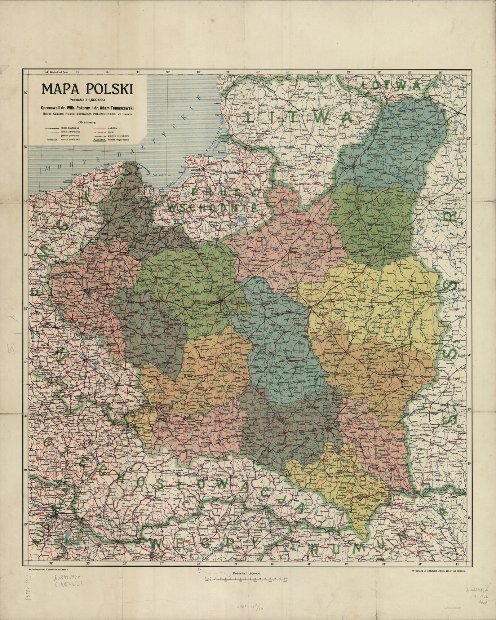
Second Polish Republic – 1927 Wilhelm Humble and Adam Tomaszewski, Mapa Polski (Bernard Połniecki Polish Bookstore, Lwów, 1927); digital images, Polona Digital Library (http://polona.pl/item/15923852/ : accessed 26 February 2019).
01 April 1938
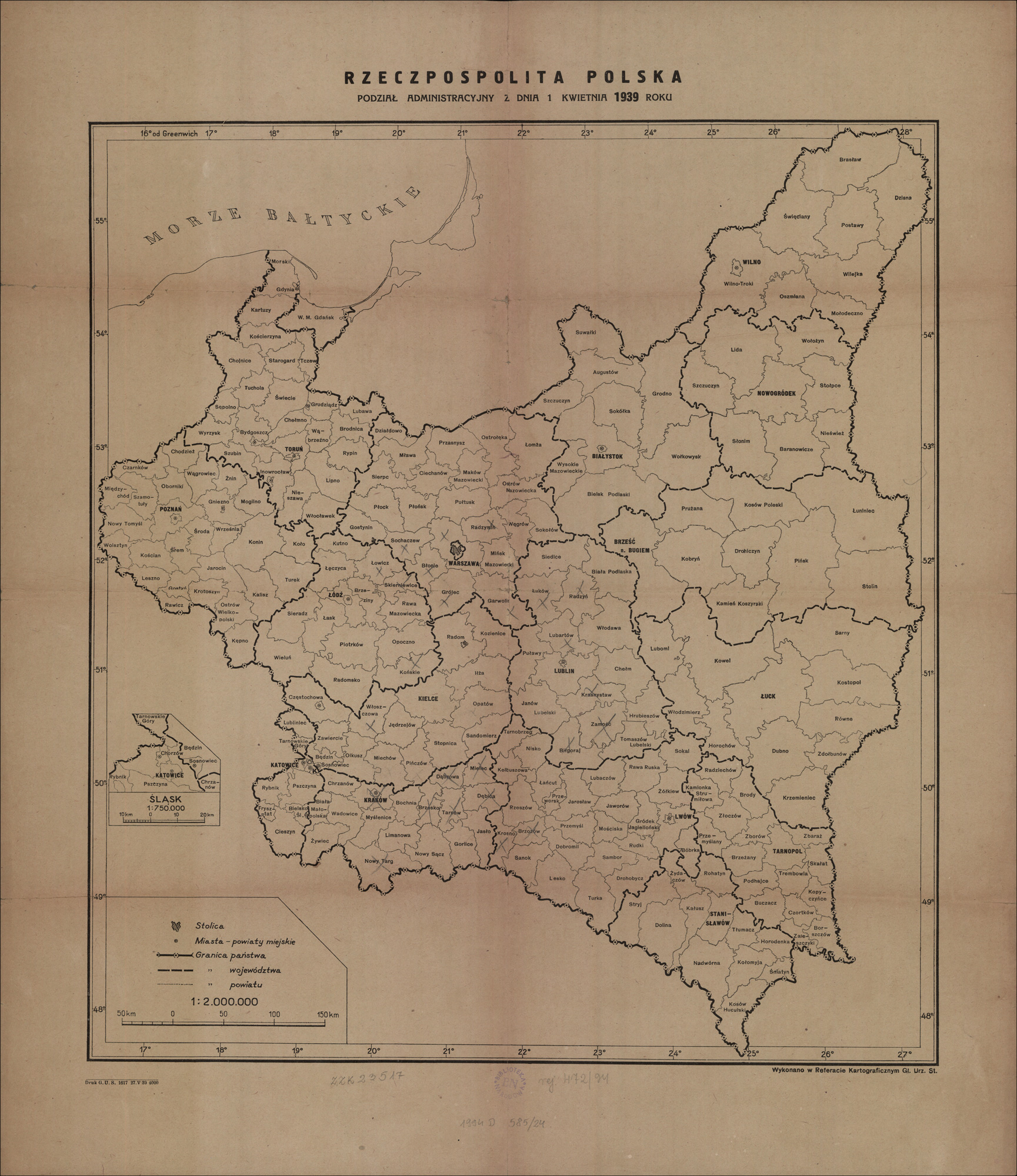
From 01 April 1938 until 31 August 1939, the administrative divisions of Poland were as follows:
Białystok Voivodeship (Powiats: Augustów, Białystok, Białystok City, Bielsk, Grodno, Sokółka, Suwałki, Szczuczyn, Wołkowysk, Wysokie Mazowieckie)
Kielce Voivodeship (Powiats: Będzin, Częstochowa, Częstochowa City, Iłża, Jędrzejów, Kielce, Kozienice, Miechów, Olkusz, Opatów, Pińczów, Radom, Radom City, Sandomierz, Sosnowiec City, Stopnica, Włoszczowa, and Zawiercie)
Kraków Voivodeship (Powiats: Biala Krakowska, Bochnia, Brzesko, Chrzanów, Dąbrowa Tarnowska, Dębica, Gorlice, Jasło, Kraków, Kraków City, Limanowa, Mielec, Myślenice, Nowy Sącz, Nowy Targ, Tarnów, Wadowice, and Żywiec)
Pomeranian Voivodeship (Powiats: Brodnica, Bydgoszcz, Bydgoszcz City, Chełmno, Chojnice, Gdynia City, Grudziądz, Grudziądz City, Inowrocław, Inowrocław City, Kartuzy, Kościerzyna, Lipno, Lubawa, Nieszawa, Rypin, Sępólno Krajeńskie, Starogard Gdańsk, Świecie, Szubin, Tczew, Toruń, Toruń City, Tuchola, Wąbrzeźno, Wejherowo, Włocławek, and Wyrzysk)
Poznań Voivodeship (Powiats: Chodzież, Czarnków, Gniezno, Gniezno City, Gostyń, Jarocin, Kalisz, Kępno, Koło, Konin, Kościan, Krotoszyn, Leszno, Międzychód, Mogilno, Nowy Tomyśl, Oborniki, Ostrów Wielkopolski, Poznań, Poznań City, Rawicz, Śrem, Środa Wielkopolska, Szamotuły, Turek, Wągrowiec, Wolsztyn, and Września)
Silesian Voivodeship (Powiats: Bielsko, Bielsko City, Chorzów City, Cieszyn, Frysztat, Katowice, Katowice City, Lubliniec, Pszczyna, Rybnik, and Tarnowskie Góry)
Second Polish Republic – 1939 Central Statistical Office of Poland, Rzeczpospolita Polska : podział administracyjny z dnia 1 Kwietnia 1939 roku (Central Statistical Office of Poland, Warsaw, 1939); digital images, Polona Digital Library (http://polona.pl/item/16885035/ : accessed 26 February 2019).
REFERENCE:
Poland. 1939. Mały rocznik statystyczny 1939. Warszawa: Nakładem Głównego Urzedu Statystycznego. Image copy. Repozytoriu Cyfrowe Instytutów Naukowych (https://rcin.org.pl/dlibra/doccontent?id=17198: 2023).
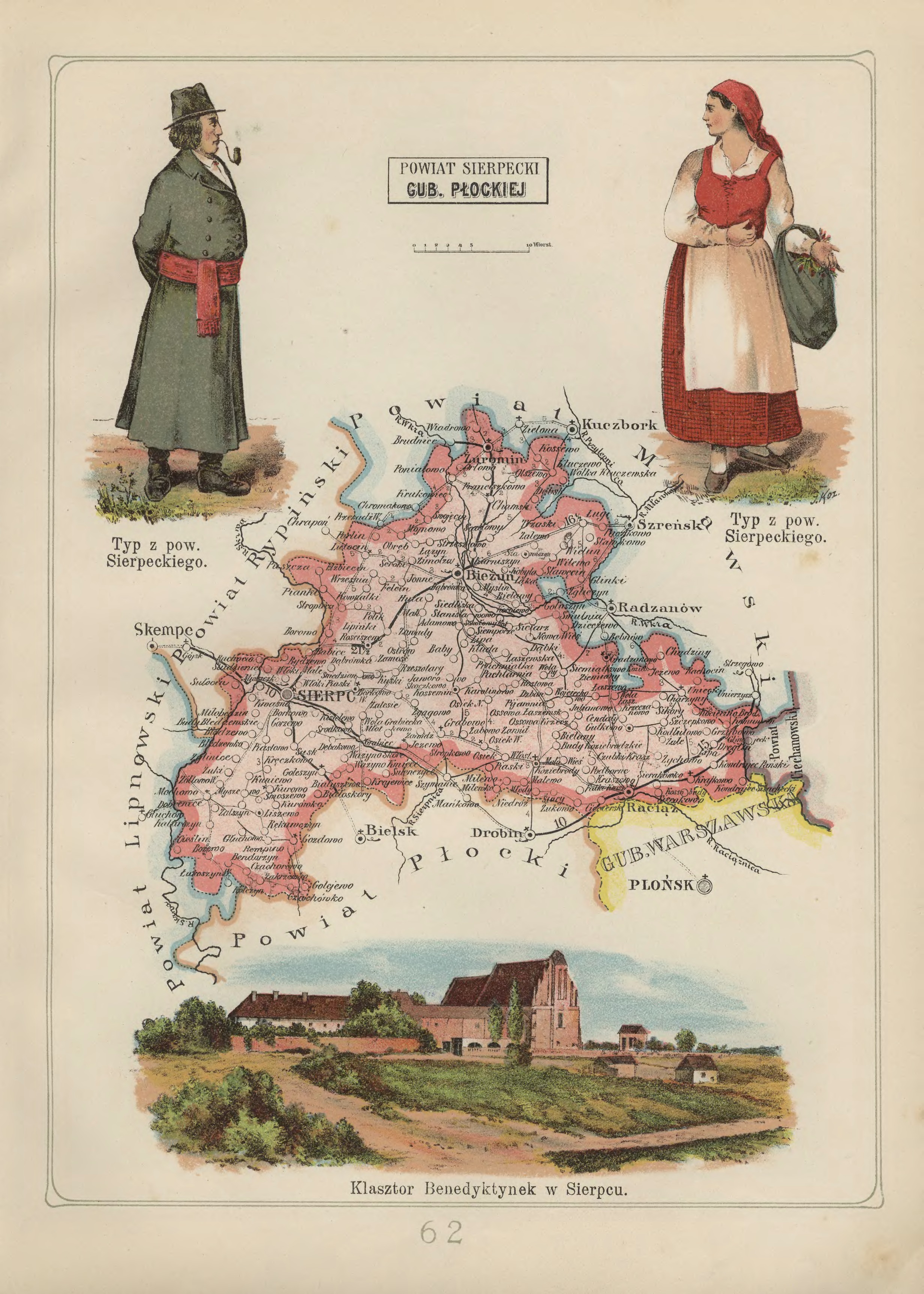
Sierpc Powiat in the Płock Gubernia – 1907 Józef Michał Bazewicz, Atlas geograficzny ilustrowany Królestwa Polskiego (Litografia B. A. Bukaty, Warsaw, 1907); digital images, Mapywig (http://igrek.amzp.pl/details.php?id=11767113 : accessed 02 February 2019).
The administrative structure of the parishes of Borkowo Kościelne, Bożewo, Gozdowo, Grabowo, Jeżewo, Kurowo, Mochowo, Osiek, Rościszewo, Sierpc, and Zawidz Kocielny can be described as follows:
01 Jul 1569-04 Oct 1795:Village, Płock Voivodeship, Crown of the Kingdom of Poland, Polish-Lithuanian Commonwealth
04 Oct 1795-08 Jul 1807:Village, Mława Powiat, Kammerdepartement Płock, Province of New East Prussia, Kingdom of Prussia
09 Jul 1807-08 Jun 1815:Village, Mława Powiat, Płock Department, Duchy of Warsaw
09 Jun 1815-15 Jan 1816:Village, Wyszogród Powiat, Płock Department, Congress Kingdom of Poland
16 Jan 1816-06 Mar 1837:Village, Mława Obwód, Płock Voivodeship, Congress Kingdom of Poland
07 Mar 1837-10 Nov 1842:Village, Mława Obwód, Płock Gubernia, Congress Kingdom of Poland
11 Nov 1842-30 Dec 1866:Village, Mława Powiat, Płock Gubernia, Congress Kingdom of Poland
31 Dec 1866-18 Oct 1915:Village, Sierpc Powiat, Płock Gubernia, Congress Kingdom of Poland
18 Oct 1915-10 Nov 1918:Village, Sierpc Powiat, General Government of Warsaw, German Empire
11 Nov 1918-31 Aug 1939:Village, Sierpc Powiat, Warsaw Voivodeship, Second Polish Republic
01 Sep 1939-27 Jun 1945:Village, Landkreis Sichelberg, Regierungsbezirk Zichenau, Province of East Prussia, German Reich
28 Jun 1945-21 Jul 1952:Village, Sierpc Powiat, Warsaw Voivodeship, Republic of Poland
In 1845, for the “general good of the country”, the borders of six gubernias in the Congress Kingdom of Poland were changed. The Kalisz Gubernia and the Masovian Gubernia were combined to form the Warsaw Gubernia with its seat in Warsaw. The Podlaski Gubernia and the Lublin Gubernia were combined to form the Lublin Gubernia with its seat in Lublin. The Sandomierz Gubernia and the Kielce Gubernia were combined to form the Radom Gubernia with its seat in Radom. The Augustów Gubernia remained unchanged with its seat in Suwalki, and the Płock Gubernia remained unchanged with its seat in Płock. The eight gubernias that had existed in the Congress Kingdom of Poland had been reduced to five.
01 January 1845
From 01 January 1845 until 30 December 1866, the administrative divisions of the Congress Kingdom of Poland were as follows:
Augustów Gubernia (Powiats: Augustów, Kalwaria, Łomża, Mariampol, and Sejny)
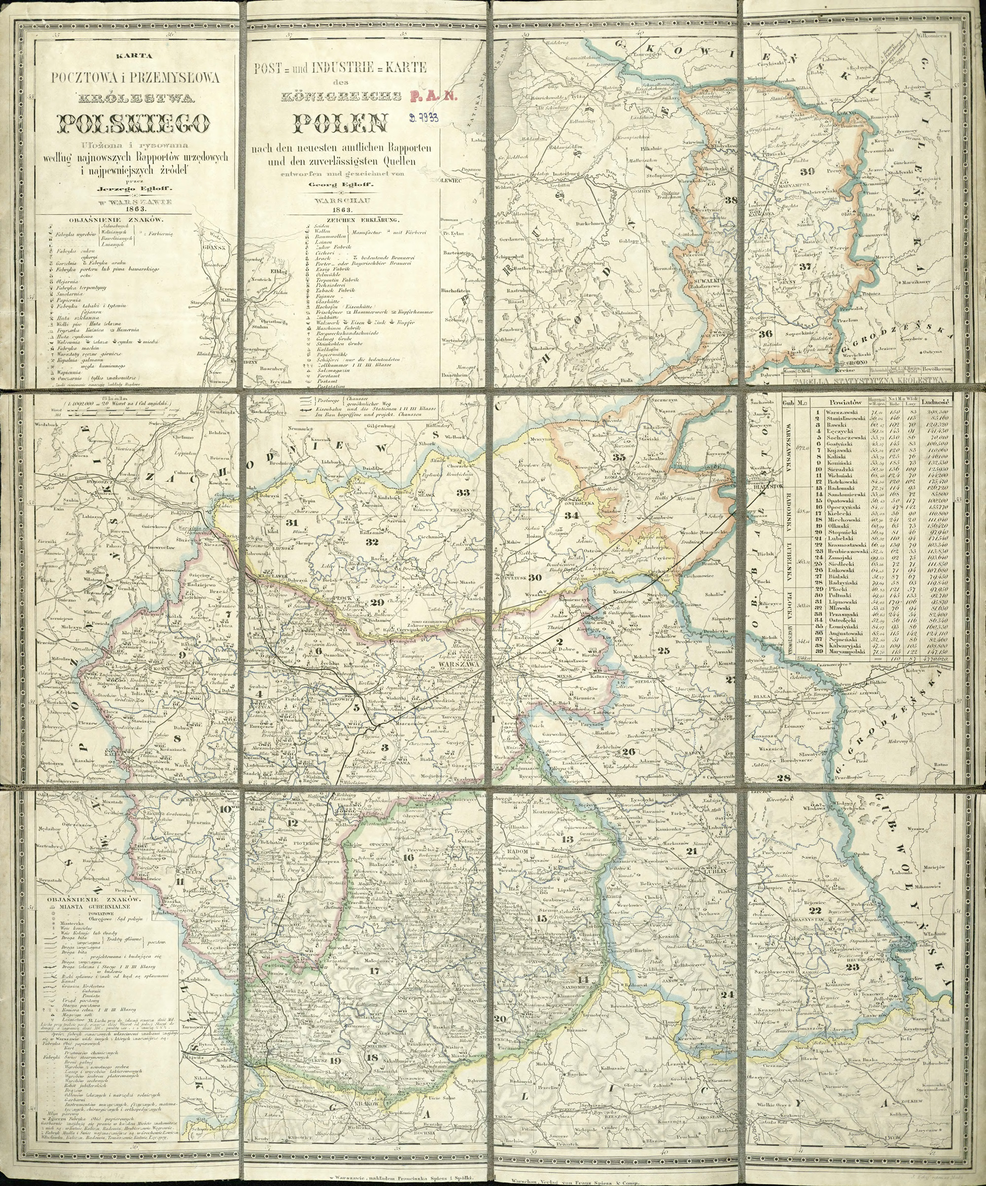
Congress Kingdom of Poland – 1845-1866 Jarzy Egloff, Karta pocztowa i przemysłowa Królestwa Polskiego (Franciszek Spiess and Company, Warsaw, 1863); digital images, Digital Repository of Scientific Institutes (http://rcin.org.pl/publication/51292 : accessed 10 February 2019).
31 December 1866
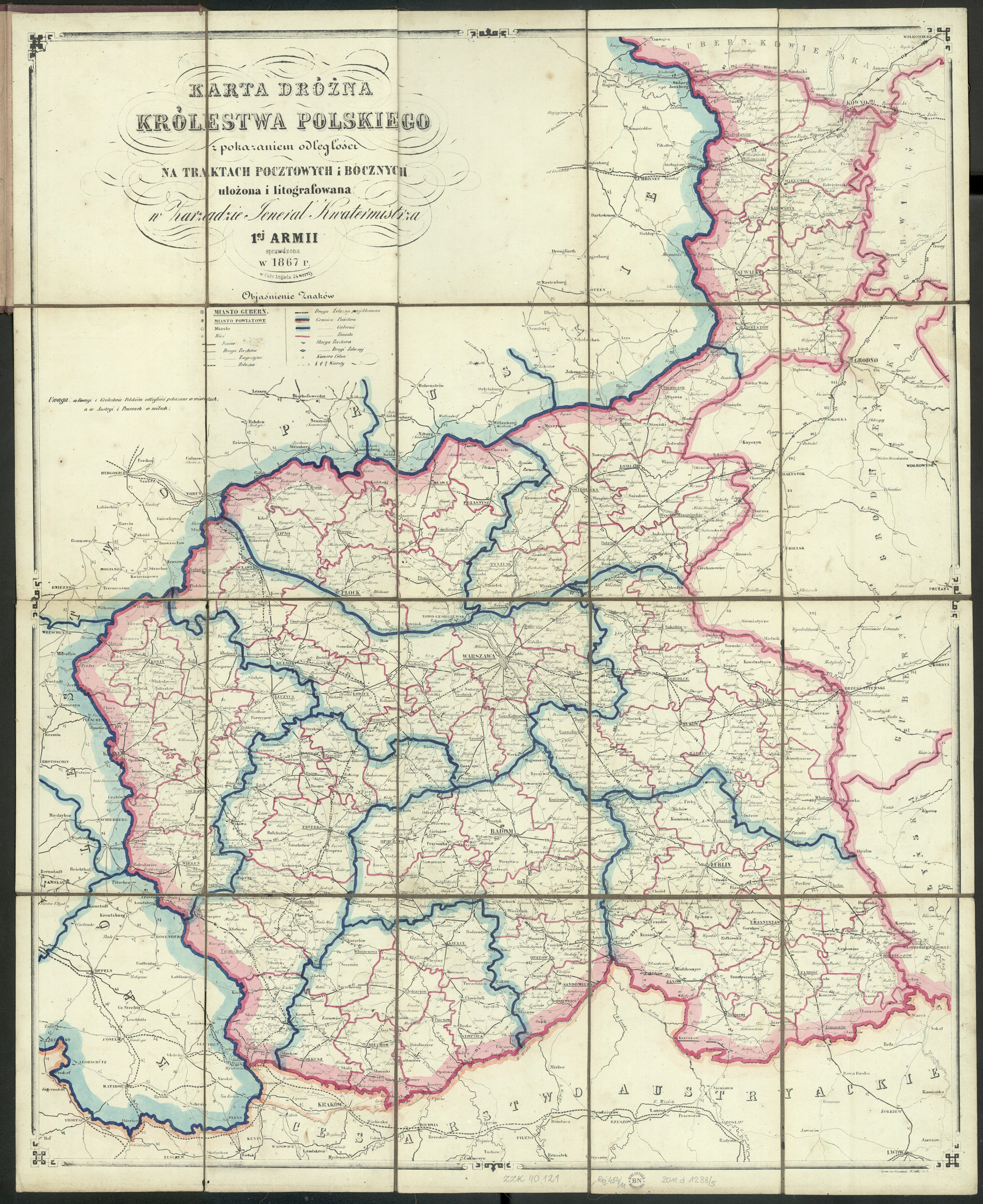
After the failure of the January Uprising (1863-1864), larger gubernias in the Congress Kingdom of Poland were divided into smaller ones. From 31 December 1866 to 10 March 1879, the administrative division of the Congress Kingdom of Poland was as follows:
Suwalki Gubernia (Powiats: Augustów, Kalwarija, Kudirkos Naumiestis [Władysławów], Marijampolė, Sejny, Suwałki, and Vilkaviškis)
Warsaw Gubernia (Powiats: Błonie, Góra Kalwarya, Gostyń, Grójec, Kutno, Łowicz, Mińsk Mazowiecki, Radzieje / later Nieszawa, Radzymin, Skierniewice, Sochaczew, Warsaw, and Włocławek)
Congress Kingdom of Poland – 1866-1879 Author unknown, Karta Drózna Królestwa Polskiego (Zarządzie General Kwatermistrza 1ej Armii, Place unknown, 1867); digital images, Polona Digital Library (http://polona.pl/item/29081074/ : accessed 09 February 2019).
NOTE: In a proclamation dated 07 September 1870, the city of Warsaw was specifically excluded from the Warsaw Gubernia, subordinate to the General-Governor of Warsaw and the Ministry of Internal Affairs in St. Petersburg.
11 March 1879
In 1879, the Górny Kalwarija Powiat was abolished and its territory was incorporated into the Grójec Powiat. From 11 March 1879 until 17 Oct 1915, the administrative division of the Congress Kingdom of Poland was as follows:
Suwalki Gubernia (Powiats: Augustów, Kalwarija, Kudirkos Naumiestis [Władysławów], Marijampolė, Sejny, Suwałki, and Vilkaviškis)
Warsaw Gubernia (Powiats: Błonie, Gostyń, Grójec, Kutno, Łowicz, Mińsk Mazowiecki, Radzieje / later Nieszawa, Radzymin, Skierniewice, Sochaczew, Warsaw, and Włocławek)
26 December 1893
In 1893, the Płońsk Powiat (Płock Gubernia) and the Pułtusk Powiat (Łomża Gubernia) were transferred to the Warsaw Gubernia. From 26 December 1893 to 17 Oct 1915, the administrative division of the Congress Kingdom of Poland was as follows:
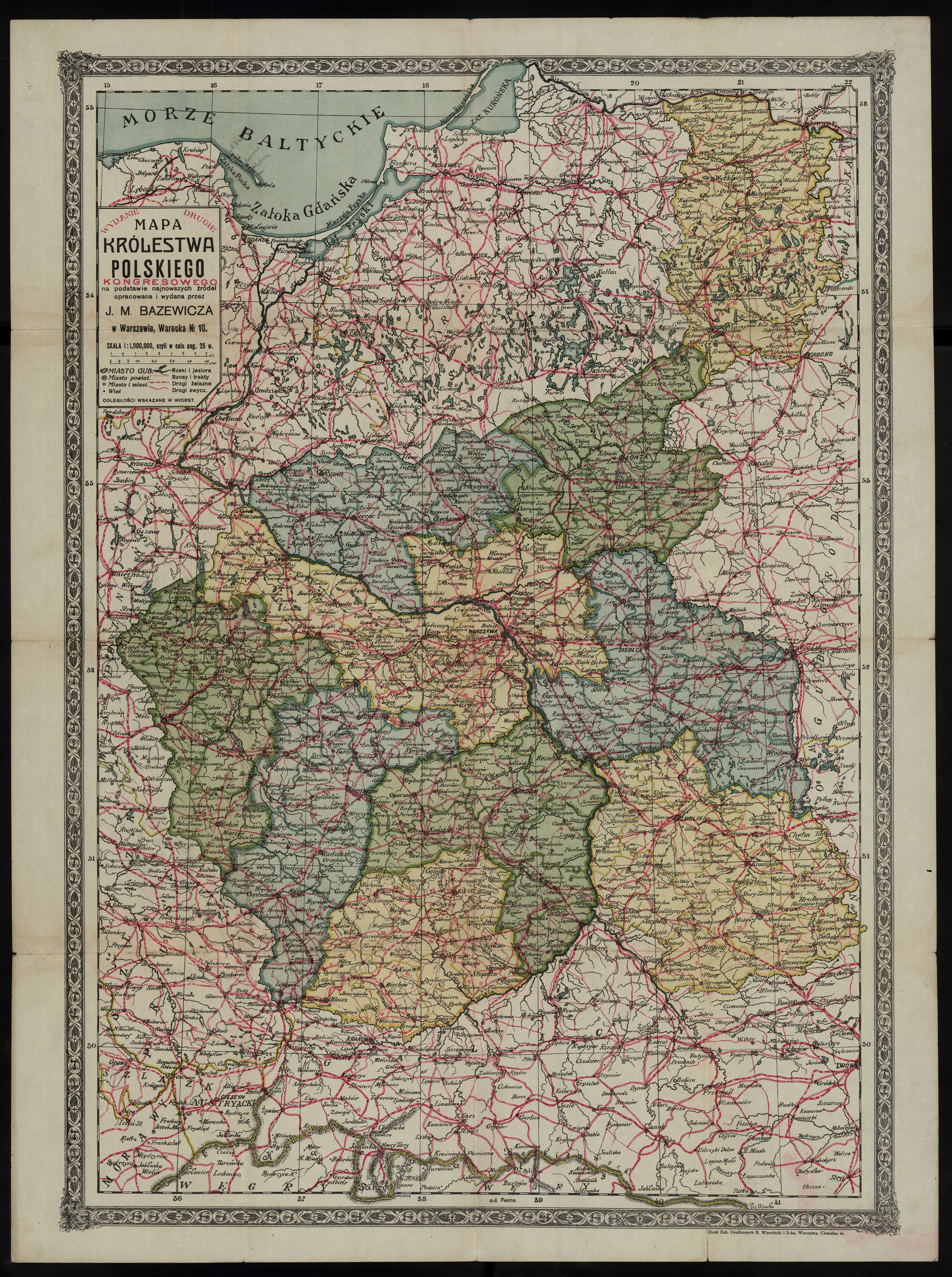
Congress Kingdom of Poland – 1893-1912 Józef Michał Bazewicz, Mapa Królestwa Polskiego Kongresowego : na podstawie najnowszych źródeł (J. M. Bazewicz, Warsaw, about 1914); digital images, Polona Digital Library (http://polona.pl/item/9989656/ : accessed 10 February 2019).
06 July 1912
On 06 July 1912, parts of the Siedlce Gubernia (the Biała Podlaska Powiat, and parts of the Konstantynów, Radzyń, and Włodawa Powiats), and the Lublin Gubernia (the Tomaszów and Hrubiezów Powiats and parts of the Lubartów, Chełm, Krasnystaw, and Biłgoraj Powiats) were split off and combined to form the new Chełm Gubernia. The Węgrów Powiat of the former Siedlce Gubernia was incorporated into the Łomża Gubernia. The remaining territory of the former Siedlce Gubernia was incorporated into the Lublin Gubernia. These changes eliminated the Siedlce Gubernia and resulted in the administrative divisions of the Congress Kingdom of Poland as follows:
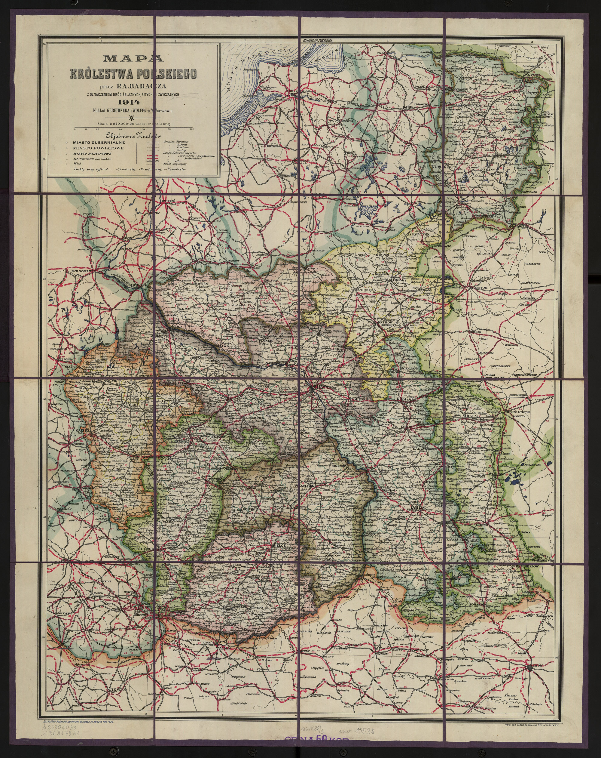
Congress Kingdom of Poland – 1912-1915 P. A. Baracz, Mapa Królestwa Polskiego : z oznaczeniem dróg żelaznych, bitych, i zwyczajnych (Gebethner and Wolff, Warsaw, 1914); digital images, Polona Digital Library (http://polona.pl/item/4901903/ : accessed 10 February 2019).
30 March 1915
On 30 March 1915, the Chełm Gubernia was annexed to the Southwest Krai of the Russian Empire and included the following administrative divisions:
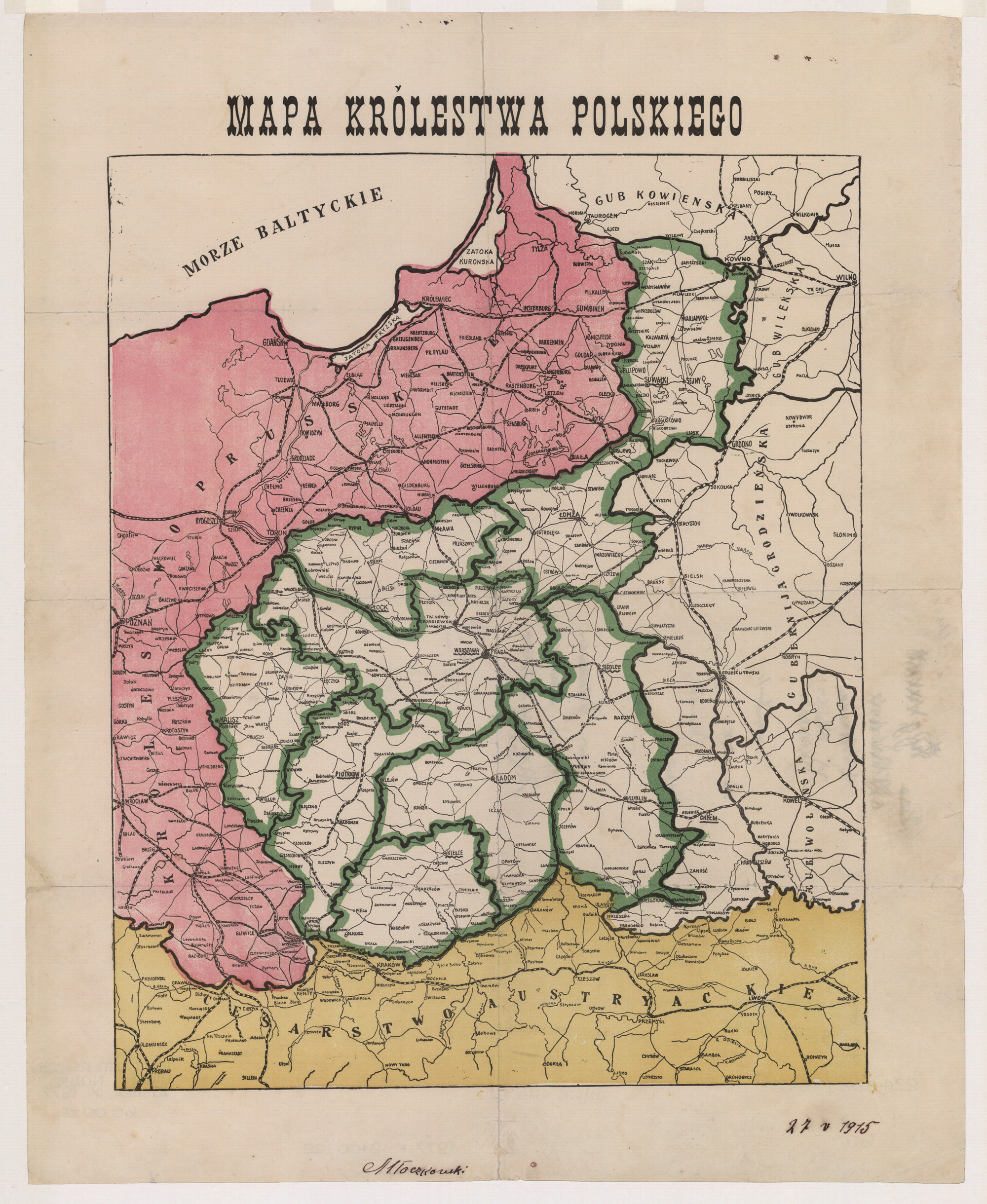
Congress Kingdom of Poland – 1915 Author unknown, Mapa Królestwa Polskiego (Publisher unknown, Place unknown, not before 1915); digital images, Polona Digital Library (http://polona.pl/item/7957782/ : accessed 10 February 2019).
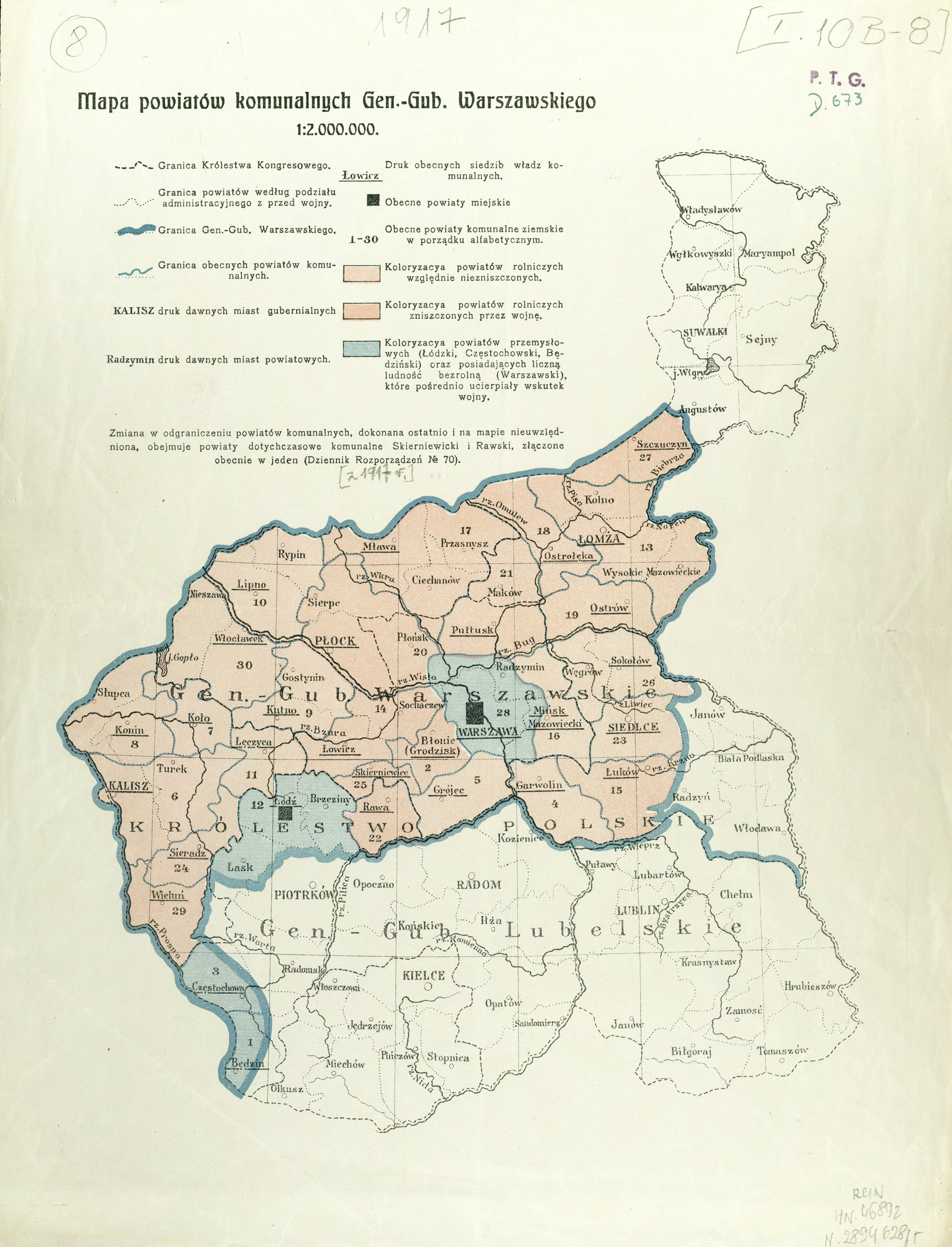
During World War I, the Central Powers divided the territory of the Kingdom of Poland into two zones: German and Austrian. On 01 September 1915, the General Government of Lublin was created from those territories occupied by Austria. The divisions of Gubernias were eliminated from both General Governments. The largest administrative divisions that remained were the Powiats.
01 Septmber 1915
General Government of Lublin: the former Radom Gubernia, Kielce Gubernia, almost all of the Lublin Gubernia from before 1912, and part of the Piotrków Gubernia
08 September 1915
On 08 September 1915, the General Government of Warsaw was created from those territories occupied by the German Empire.
General Government of Warsaw: the former Suwalki, Łomża, Płock, Siedlce, and Warsaw Gubernias, almost all of the Kalisz Gubernia (without the Wieluń Powiat), part of the Piotrków Gubernia (all or part of the Brzeziny, Rawa, Łódź, Łasdk, Częstochowa, and Będzin Powiats), and the one powiat from the Lublin Gubernia (Puławy)
Powiats Włodaw, Radzyn, Bialsk, and Konstantynów were not included in the General Government of Warsaw so that they could be offered to a potential pro-German Ukrainian State
Suwalki Gubernia was not included in the General Government of Warsaw so that it could be included in the Lithuanian State which was politically connected to the German Reich
Gubernias were abolished and several powiats were combined to form 30 powiats in the General Government of Warsaw, numbered in alphabetical order:
Będzin
Błonie
Częstochowa
Garwolin
Grójec
Kalisz
Koło
Konin
Kutno
Lipno
Łęczyca
Łódż
Łomża
Łowicz
Łuków
Mińsk Mazowiecki
Mława
Ostrołęka
Ostrów
Płock
Pułtusk
Rawa
Siedlce
Sieradz
Skierniewice
Sokołów
Szczuczyn
Warszawa
Wieluń
Włocławek
15 June 1916
General Government of Lublin: the former Chełm, Hrubieszów, and Tomaszów Powiats were incorporated into the General Government of Lublin
General Governments of Warsaw and Lublin – 1915-1918 Author unknown, Mapa powiatów komunalnych Gen.-Gub. Warszawskiego (Publisher unknown, Place unknown, between 1915-1918); digital images, Digital Repository of Scientific Institutes (http://rcin.org.pl/publication/52547 : accessed 10 February 2019).
REFERENCES:
Trzebiński, Wojciech, and Adam Borkiewicz. 1956. Podziały administracyjne Królestwa Polskiego w okresie 1815-1918 r.: (zarys historyczny). Warszawa: Polska Akademia Nauk. Instytut Geografii. Image copy. Digital Repository of Scientific Institutes (http://rcin.org.pl/publication/50581 : 2019).
Borkiewicz, Adam Józzef. 1956. Podziały administracyjne Królestwa Polskiego w okresie 1815-1918 r.: mapy. Warszawa: Polska Akademia Nauk. Instytut Geografii. Image copy. Digital Repository of Scientific Institutes (http://rcin.org.pl/publication/50583 : 2019).
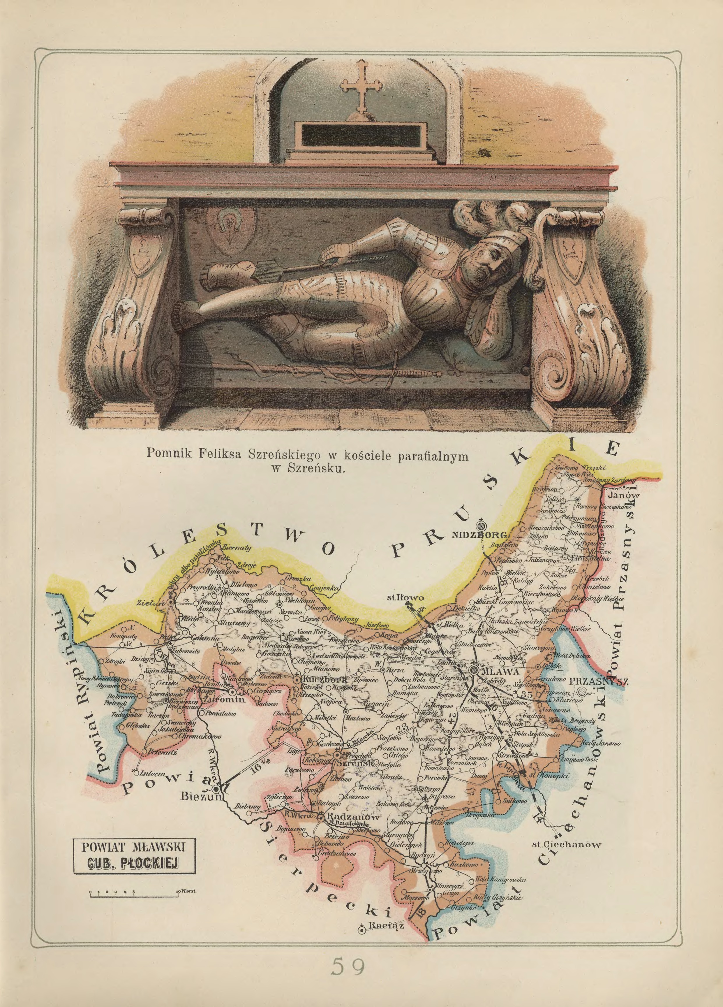
Mława Powiat in the Płock Gubernia – 1907 Józef Michał Bazewicz, Atlas geograficzny ilustrowany Królestwa Polskiego (Litografia B. A. Bukaty, Warsaw, 1907); digital images, Mapywig (http://igrek.amzp.pl/details.php?id=11767110 : accessed 02 February 2019).
The administrative structure of the parishes of Bogurzyn, Dąbrowa, Grzebsk, Kuklin, Lipowiec Kościelny, Łęg, Mława, Radzanów, Stupsk, Strzegowo, Szreńsk, Szydłowo, Unierzyż, Wieczfnia Kościelna, Wojnówka, Wyszyny Kościelne, Zgliczyn, Żmijewo Kościelne, and Żurominek can be described as follows:
01 Jul 1569-03 Oct 1795:Village, Zawkrze Ziemia, Płock Voivodeship, Crown of the Kingdom of Poland, Polish-Lithuanian Commonwealth
04 Oct 1795-08 Jul 1807:Village, Kammerdepartement Płock, Province of New East Prussia, Kingdom of Prussia
09 Jul 1807-08 Jun 1815:Village, Mława Powiat, Płock Department, Duchy of Warsaw
09 Jun 1815-15 Jan 1816:Village, Mława Powiat, Płock Department, Congress Kingdom of Poland
16 Jan 1816-06 Mar 1837:Village, Mława Obwód, Płock Voivodeship, Congress Kingdom of Poland
07 Mar 1837-10 Nov 1842:Village, Mława Obwód, Płock Gubernia, Congress Kingdom of Poland
11 Nov 1842-17 Oct 1915:Village, Mława Powiat, Płock Gubernia, Congress Kingdom of Poland
18 Oct 1915-10 Nov 1918:Village, Mława Powiat, General Government of Warsaw, German Empire
11 Nov 1918-31 Aug 1939:Village, Mława Powiat, Warsaw Voivodeship, Second Polish Republic
01 Sep 1939-27 Jun 1945:Village, Landkreis Mielau, Regierungsbezirk Zichenau, Province of East Prussia, German Reich
28 Jun 1945-21 Jul 1952:Village, Mława Powiat, Warsaw Voivodeship, Republic of Poland
The War of the Fourth Coalition against Napoleon’s French Empire ended with the Treaties of Tilsit, the first signed on 07 July 1907 between the French Empire and Imperial Russia, and the second signed on 09 July 1807 between the French Empire and the Kingdom of Prussia.
In 1807, the Treaties of Tilsit resulted in the creation of of the Duchy of Warsaw from the territories previously acquired by Prussia during the partition of Pland. Part of the territories from the first, all of the second, and all of the third Prussian partitions of Poland became the Duchy of Warsaw.
The War of the Fifth Coalition against the French Empire ended with the Peace in Schrönbrunn on 14 October 1809. As a result, the Duchy was enlarged by the addition of the territories acquired by Austria during the third partition of Poland and the Zamość Kreis of Eastern Galicia.
While nominally free, the Duchy of Warsaw was subordinate to the French Empire.
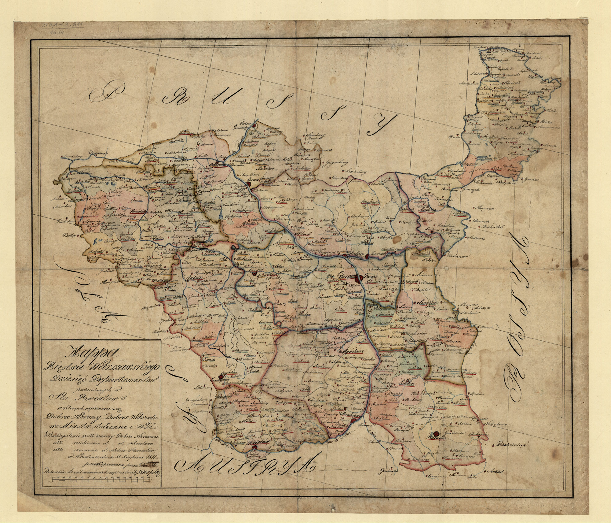
The Duchy of Warsaw – 1811 (Unknown, Mappa Xięstwa Warszawskiego: Dziesięć Departamentów Podzielonych w Sto Powiatów (Publisher Unknown, Kraków, 1811); digital images, Polona Digital Library (http://polona.pl/item/3750917/ : accessed 20 January 2019).
The initial administrative division of the Duchy of Warsaw into six departments and 60 powiats was based on the previous administrative division by Prussia.
Bydgoszcz Department
Breść Powiat
Bydgoszcz Powiat
Chełmno Powiat
Inowrocław Powiat
Kamiń Powiat
Kowal Powiat
Michałowo Powiat
Radziejów Powiat
Toruń Powiat
Wojecki Powiat
Kalisz Department
Częstochowa Powiat
Kalisz Powiat
Konin Powiat
Odolanów Powiat
Ostrzeszów Powiat
Piotrków Powiat
Radomsko Powiat
Sieradz Powiat
Szadkowice Powiat
Warcia Powiat
Wieluń Powiat
New Silesia
Siewierz Powiat and Pilicki Powiat (until 08 December 1807)
Lelów-Siewerz Powiat (beginning on 09 December 1807)
Lelów Powiat and Pilicki Powiat (beginning on 12 December 1808)
Incorporated into the Kraków Department on 17 April 1810
Łomża Department
Biebrza Powiat (seat in Szczuczyn)
Dąbrowa Powiat (seat in Lipsk, later in Augustów)
Kalwaria Powiat
Łomża Powiat
Mariampol Powiat
Tykocin Powiat
Wigry Powiat
Sejny Powiat (after separating from the Wigry parish on 06 May 1808)
Płock Department
Lipińskie Powiat
Mława Powiat
Ostrołęcka Powiat
Pułtusk Powiat
Przasnysz Powiat
Wyszogród Powiat
Poznań Department
Babimost Powiat
Gniezno Powiat
Kościan Powiat
Krobów Powiat
Krotoszyn Powiat
Międzrzecz Powiat
Oborniki Powiat
Powidzki Powiat
Poznań Powiat
Pyzdry Powiat
Śrem Powiat
Środa Powiat
Wągrowiec Powiat
Wschowa Powiat
Warsaw Department
Błonie Powiat
Brzeziny Powiat
Czersk Powiat
Gostynin Powiat
Łęczyca Powiat
Orłowo Powiat
Rawa Powiat
Sochaczew Powiat
Warsaw Powiat
Zgierz Powiat
Siennica Powiat
Incorporated into the Warsaw Department on 17 April 1810)
Stanisławów Powiat
Incorporated into the Warsaw Department on 17 April 1810)
The Peace in Schrönbrunn concluded on 14 October 1809. On 24 February 1810, the territories acquired from Austria were divided into four departments, and on 17 April 1810, the new departments were divided into forty powiats.
Kraków Department
Hebdów Powiat
Jędrejów Powiat
Kraków Powiat
Krzeszowice Powiat
Miechów Powiat
Olkusz Powiat
Skalbmierz Powiat
Stopnica Powiat
Szydłowiec Powiat
Pilica Powiat (from the Kalisz Department)
Lelów Powiat (from the Kalisz Department)
Lublin Department
Chełm Powiat
Hrubieszów Powiat
Kaźmierki Powiat
Krasnystaw Powiat
Kraśnik Powiat
Lubartów Powiat
Lublin Powiat
Tarnogród Powiat
Tomaszów Powiat
Zamość Powiat
Radom Department
Kielce Powiat
Końskie Powiat
Kozienice Powiat
Opatów Powiat
Opoczno Powait
Radom Powiat
Sandomierz Powiat
Solec Powiat
Staszów Powiat
Szydłowiec Powiat
Siedlce Department
Biała Powiat
Garwolin Powiat
Łosice Powiat
Łuków Powiat
Radzyń Powiat
Siedlce Powiat
Węgrów Powiat
Włodawa Powiat
Żelechów Powiat
Seven cities were declared Municipal Offices: Warsaw, Poznań, Kalisz, Toruń, Kraków, Lublin, and Sandomierz.
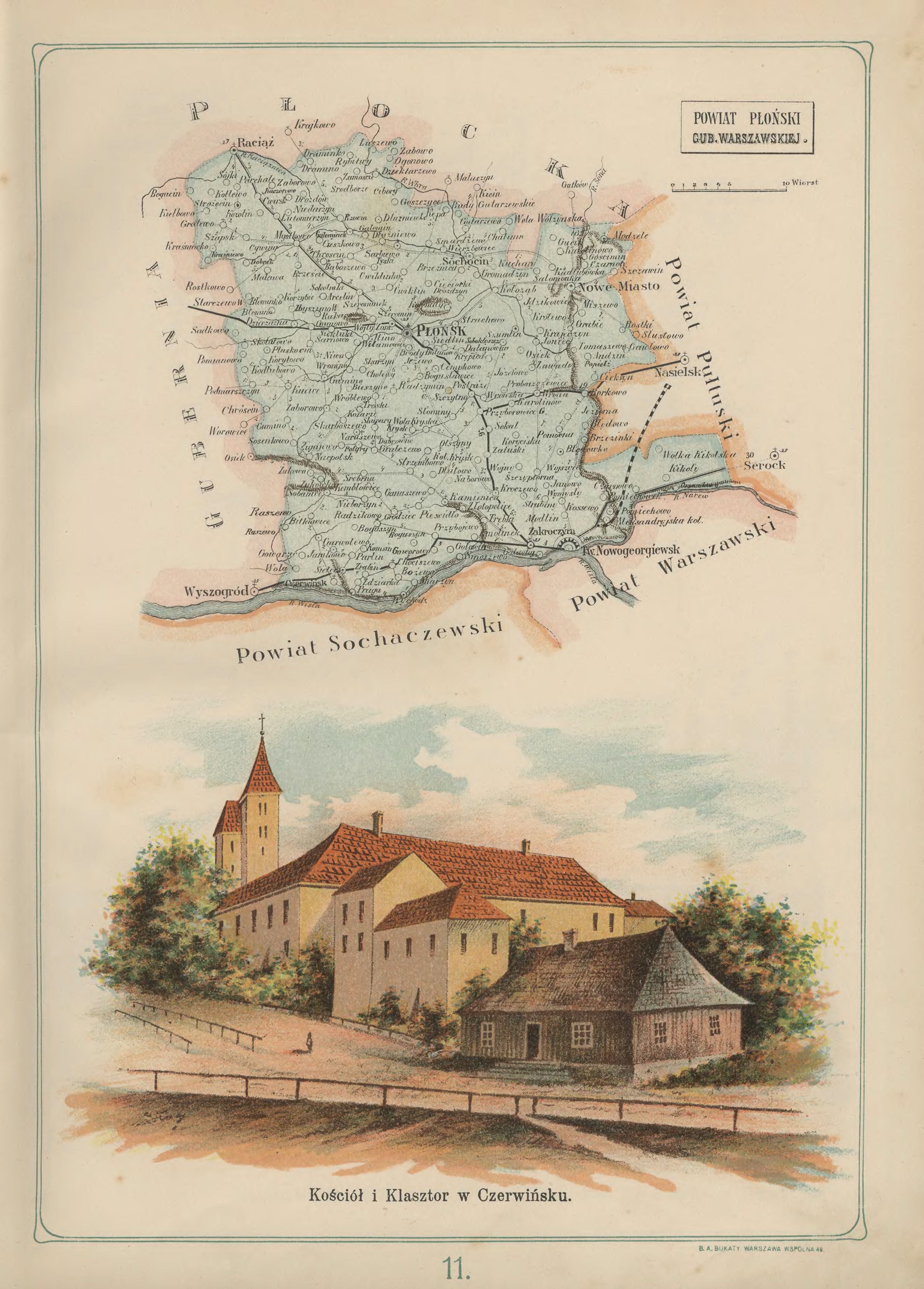
Płońsk Powiat in the Warsaw Gubernia – 1907 Józef Michał Bazewicz, Atlas geograficzny ilustrowany Królestwa Polskiego (Litografia B. A. Bukaty, Warsaw, 1907); digital images, Mapywig (http://igrek.amzp.pl/details.php?id=11767062 : accessed 02 February 2019).
The administrative structure of the parishes of Baboszewo, Czerwińsk, Dziektarzewo, Gromadzyn, Gumino, Joniec, Kamienica, Kroczewo, Królewo, Krysk, Kucice, Naruszewo, Płońsk, Radzikowo, Radzymin, Radzyminek, Sarbiewo, Skołatowo, Sochocin, Wierzbowiec, Wrona, Żukowo can be described as follows:
01 Jul 1569-03 Oct 1795:Village, Masovia Voivodeship, Crown of the Kingdom of Poland, Polish-Lithuanian Commonwealth
04 Oct 1795-08 Jul 1807:Village, Kammerdepartement Płock, Province of New East Prussia, Kingdom of Prussia
09 Jul 1807-08 Jun 1815:Village, Wyszogród Powiat, Płock Department, Duchy of Warsaw
09 Jun 1815-15 Jan 1816:Village, Wyszogród Powiat, Płock Department, Congress Kingdom of Poland
16 Jan 1816-06 Mar 1837:Village, Płock Obwód, Płock Voivodeship, Congress Kingdom of Poland
07 Mar 1837-10 Nov 1842:Village, Płock Obwód, Płock Gubernia, Congress Kingdom of Poland
11 Nov 1842-30 Dec 1866:Village, Płock Powiat, Płock Gubernia, Congress Kingdom of Poland
31 Dec 1866-25 Dec 1893:Village, Płońsk Powiat, Płock Gubernia, Congress Kingdom of Poland
26 Dec 1893-17 Oct 1915:Village, Płońsk Powiat, Warsaw Gubernia, Congress Kingdom of Poland
18 Oct 1915-10 Nov 1918:Village, Płońsk Powiat, General Government of Warsaw, German Empire
11 Nov 1918-31 Aug 1939:Village, Płońsk Powiat, Warsaw Voivodeship, Second Polish Republic
01 Sep 1939-27 Jun 1945:Village, Landkreis Plöhnen, Regierungsbezirk Zichenau, Province of West Prussia, German Reich
28 Jun 1945-21 Jul 1952:Village, Płonśk Powiat, Warsaw Voivodeship, Republic of Poland
01 Jun 1975-30 Dec 1989:Village, Płock Voivodeship, Polish People’s Republic
31 Dec 1989-30 Dec 1998:Village, Płock Voivodeship, Third Polish Republic
31 Dec 1998-Present:Village, Płonsk Powiat, Masovian Voivodeship, Third Polish Republic
The administrative structure of the parishes of Cieksyn, Kolonia Aleksandryka (now known as Stanisławowo), Pomiechówek, Pomiechowo, Smoszewo, and Zakroczym can be described as follows:
01 Jul 1569-03 Oct 1795:Village, Zakroczym Ziemia, Masovia Voivodeship, Crown of the Kingdom of Poland, Polish-Lithuanian Commonwealth
04 Oct 1795-08 Jul 1807:Village, Kammerdepartement Płock, Province of New East Prussia, Kingdom of Prussia
09 Jul 1807-08 Jun 1815:Village, Wyszogród Powiat, Płock Department, Duchy of Warsaw
09 Jun 1815-15 Jan 1816:Village, Wyszogród Powiat, Płock Department, Congress Kingdom of Poland
16 Jan 1816-06 Mar 1837:Village, Płock Obwód, Płock Voivodeship, Congress Kingdom of Poland
07 Mar 1837-10 Nov 1842:Village, Płock Obwód, Płock Gubernia, Congress Kingdom of Poland
11 Nov 1842-30 Dec 1866:Village, Płock Powiat, Płock Gubernia, Congress Kingdom of Poland
31 Dec 1866-25 Dec 1893:Village, Płońsk Powiat, Płock Gubernia, Congress Kingdom of Poland
26 Dec 1893-17 Oct 1915:Village, Płońsk Powiat, Warsaw Gubernia, Congress Kingdom of Poland
18 Oct 1915-10 Nov 1918:Village, Płońsk Powiat, General Government of Warsaw, German Empire
11 Nov 1918-31 Aug 1939:Village, Warsaw Powiat, Warsaw Voivodeship, Second Polish Republic
01 Sep 1939-27 Jun 1945:Village, Landkreis Plöhnen, Regierungsbezirk Zichenau, Province of West Prussia, German Reich
28 Jun 1945-21 Jul 1952:Village, Nowy Dwór Powiat Warsaw Voivodeship, Republic of Poland
22 Jul 1952-31 May 1975:Village, Nowy Dwór Powiat, Warsaw Voivodeship, Polish People’s Republic
01 Jun 1975-30 Dec 1989:Village, Warsaw Voivodeship, Polish People’s Republic
31 Dec 1989-30 Dec 1998:Village, Warsaw Voivodeship, Third Polish Republic
31 Dec 1998-Present:Village, Nowy Dwór Powiat, Masovian Voivodeship, Third Polish Republic
The administrative structure of the parish of Radzikowo (now known as Stare Radzikowo) can be described as follows:
01 Jul 1569-03 Oct 1795:Village, Masovia Voivodeship, Crown of the Kingdom of Poland, Polish-Lithuanian Commonwealth
04 Oct 1795-08 Jul 1807:Village, Kammerdepartement Płock, Province of New East Prussia, Kingdom of Prussia
09 Jul 1807-08 Jun 1815:Village, Płock Powiat, Płock Department, Duchy of Warsaw
09 Jun 1815-15 Jan 1816:Village, Płock Powiat, Płock Department, Congress Kingdom of Poland
16 Jan 1816-06 Mar 1837:Village, Płock Obwód, Płock Voivodeship, Congress Kingdom of Poland
07 Mar 1837-10 Nov 1842:Village, Płock Obwód, Płock Gubernia, Congress Kingdom of Poland
11 Nov 1842-30 Dec 1866:Village, Płock Powiat, Płock Gubernia, Congress Kingdom of Poland
31 Dec 1866-25 Dec 1893:Village, Płońsk Powiat, Płock Gubernia, Congress Kingdom of Poland
26 Dec 1893-17 Oct 1915:Village, Płońsk Powiat, Warsaw Gubernia, Congress Kingdom of Poland
18 Oct 1915-10 Nov 1918:Village, Płońsk Powiat, General Government of Warsaw, German Empire
11 Nov 1918-31 Aug 1939:Village, Płońsk Powiat, Warsaw Voivodeship, Second Polish Republic
01 Sep 1939-27 Jun 1945:Village, Landkreis Plöhnen, Regierungsbezirk Zichenau, Province of West Prussia, German Reich
28 Jun 1945-21 Jul 1952:Village, Płonśk Powiat, Warsaw Voivodeship, Republic of Poland