The Polish Village of Szelków (Szelków Parish)

The Słownik Geograficzny Królestwa Polskiego i Innych Krajów Słowiańskich (Geographical Dictionary of the Kingdom of Poland and other Slavonic Countries) includes three entries for the Polish village of Szelków, two of which apply to the village currently known as Stary Szelków near Maków Mazowiecki. The third entry applies to the village of Shel’viv (Шельвів) which is now in the Volyn Oblast of Ukraine and which will not be discussed here.

Today, the parish of St. Simon and Jude Thaddeus is seated in Stary Szelkow. According to the parish website, the parish includes the villages of Ciepielewo, Kaptury, Laski, Łaś, Magnuszew Duży, Magnuszew Mały, Nowy Sielc, Nowy Strachocin, Nowy Szelków, Orzyc, Rostki, Smrock Dwór, Smrock Kolonia, Stary Sielc, Stary Strachocin, Stary Szelków, and Św. Rozalia-Słojki.

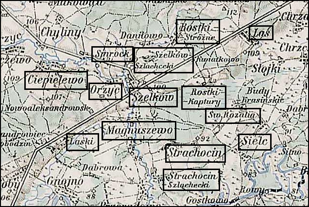
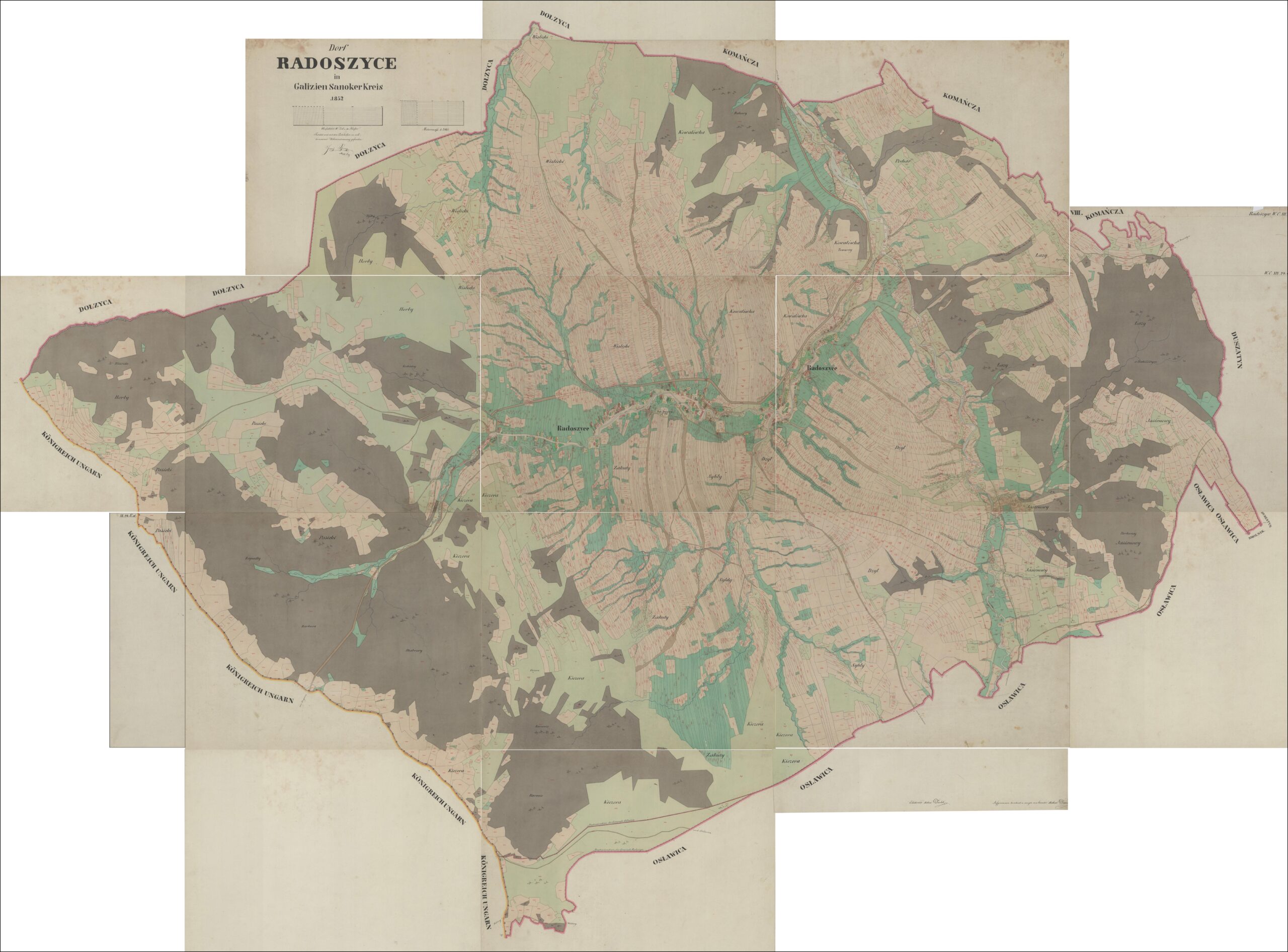
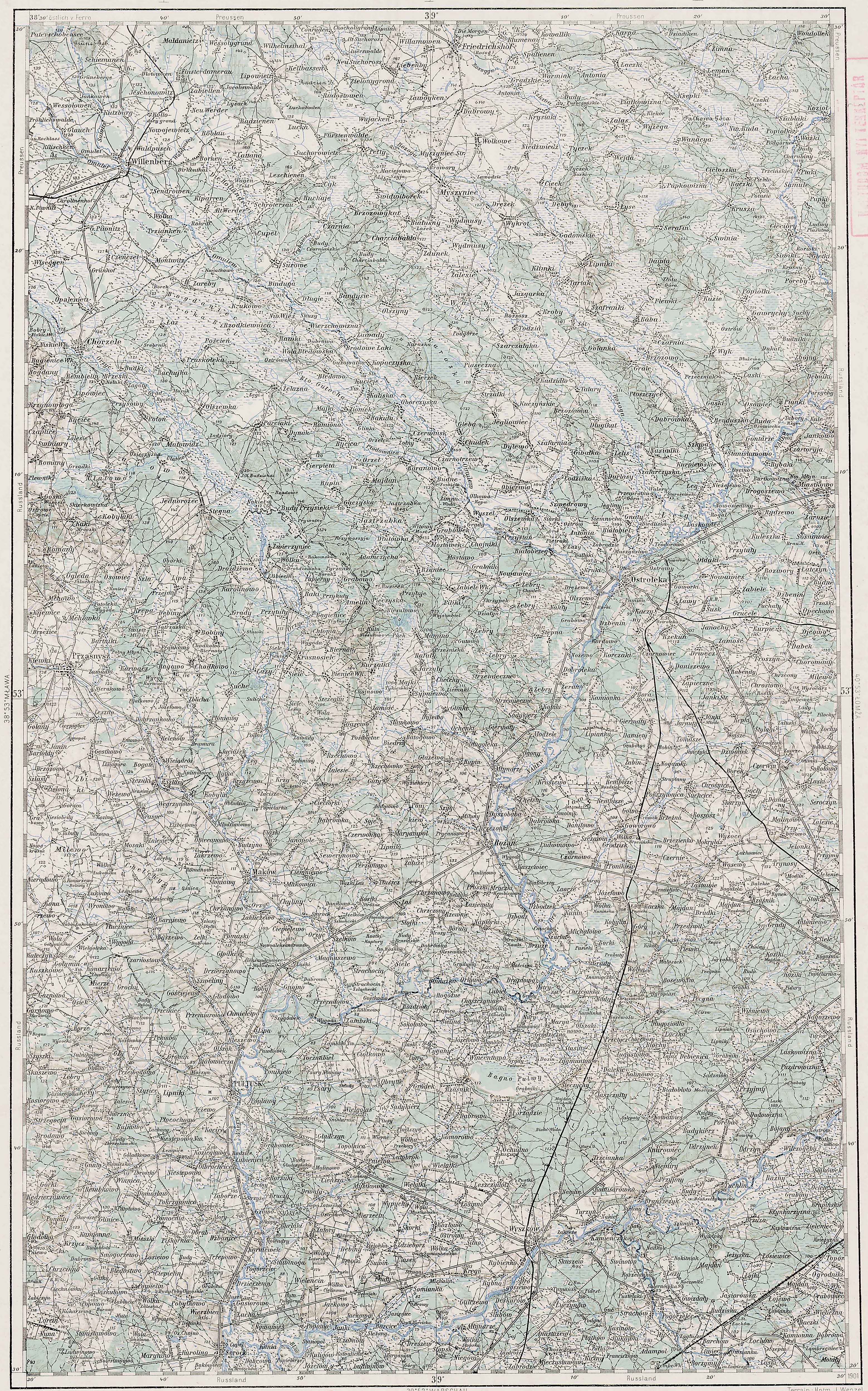
Szelków and Surrounding Area – 1910

Third Military Mapping Survey of Austria-Hungary (ELTE Faculty of Informatics,
Institute of Cartography and Geoinformatics); digital images, Lazarus ELTE
(http://lazarus.elte.hu/hun/digkonyv/topo/200e/39-53.jpg: accessed 20 December 2025)

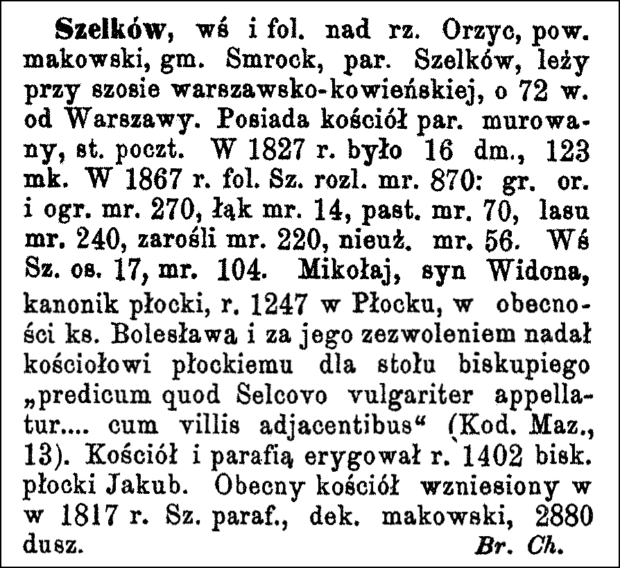
Source: Chlebowski, Bronisław and Władysław Walewski, eds., Słownik Geograficzny Królestwa Polskiego i Innych Krajów Słowiańskich (Geographical Dictionary of the Kingdom of Poland and other Slavonic Countries) – Warsaw 1890, Volume XI, page 890.

Click on the link for a PDF copy of the the Słownik Geograficzny entries for Szelków. Translated from the Polish, the first entry reads:

     Szelków, a village and manor estate on the Orzyc River, Maków powiat, Smrock gmina, Szelków parish, is located on the Warsaw-Kowno highway, 72 km from Warsaw. It has a brick parish church and a post office. In 1827, there were 16 houses and 123 inhabitants. In 1867, the Szelków manor estate covered 870 mórgs [Gerald Ortell’s book on Polish Parish Records states that in the Russian partition 1 mórg = 1.388 acres]: 270 mórgs of arable land and gardens, 14 mórgs of meadows, 70 mórgs of pastures, 240 mórgs of forest, 220 mórgs of thickets, and 56 mórgs of unproductive land. The village of Szelków had 17 settlements and 104 mórgs of land. Mikołaj, son of Widon, a canon of Płock, in 1247 in Płock, in the presence of Prince Bolesław and with his permission, granted to the Płock church for the bishop’s table “the estate which is commonly called Selcovo… with the adjacent villages” (Kod. Maz., 13). The church and parish were established in 1402 by Bishop Jakub of Płock. The present church was built in 1817. Szelków parish, Maków deanery, 2880 souls. Bronisław Chlebowski

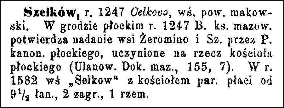
Source: Chlebowski, Bronisław, ed., Słownik Geograficzny Królestwa Polskiego i Innych Krajów Słowiańskich (Geographical Dictionary of the Kingdom of Poland and other Slavonic
Countries
) – Warsaw 1902, Volume XV Part II, page 641.

Translated from the Polish, the second entry reads:

     Szelków, Celkovo in the year 1247, village, Maków powiat. In the Płock castle in 1247, Bolesław I, the Duke of Mazovia, confirmed the grant of the villages of Żeromino and Szelków by P., the canon of Płock, to the Płock church (Ulanow. Documents of Mazovia, 155, 7). In 1582, the village of “Selkow” with its parish church paid taxes on 9 1/2 łans (land units), 2 homesteads, and 1 craftsman.

Copyright © 2025 by Stephen J. Danko

Posted in Daily Journal | Comments Off on The Polish Village of Szelków (Szelków Parish)

Cadastral Map of the Polish Village of Komańcza – 1852

The cadastral map of the Polish village of Komańcza, created by officials of the Austrian Empire in 1852 is available on the website of the Polish State Archives at Szukaj w Archiwach. The files at Szukaj w Archiwach include thirteen images that, together, form the complete map.

Komańcza Cadastral Map – 1852
Dorf Komańcza in Galizien Sanoker Kreis 1852 (State Archives in Poland); digital images, Szukaj w Archiwach
(https://www.szukajwarchiwach.gov.pl/en/jednostka/-/jednostka/18050674: accessed 20 December 2025)

Copyright © 2025 by Stephen J. Danko

Posted in Daily Journal | Comments Off on Cadastral Map of the Polish Village of Komańcza – 1852

The Dictionary of Polish Place Names – Komańcza

The Dictionary of Polish Place Names (Nazwy Miejscowe Polski) explains the origin of place names in Poland and details how the place name changed over time.

Volume V of Nazwy Miejscowe Polski lists one place called Komańcza. The village is currently in Podkarpackie Voivodeship. Szukaj w Archiwach has scanned images of birth/marriage, and death records from 1784-1830 + 1840, and 1830-1851 for the Greek Catholic Church in Komańcza, with branches in Czystohorb and Dołżyca.

Nazwy Miejscowe Polski indicates that Czystogarb was in the Komańcza Gmina, Krosno Voivodeship in the years 1975-1998, and is 25 kilometers southwest of Zagórz. Mentions of the village include “to locate a new village on the river Komanycza, which village will be called Crziemyenna … into the Comancza river” in 1512, Komancza in 1524, “from Komańcza, in Komańcza” in 1561, from Komańcza in 1638, “village of Komancza” in 1786, Komancza in 1794, Komanča in 1860, Komańcza in 1883, and Komańcza, -czy, komaniecki in 1966.

The name of the village may originate with the name of the river Komańcza. Alternatively, the name may be derived from Komanec a member of the Turkic Ko(u)man tribe, also known as Polovtsy, who lived in the territory of Rus’ in the 11th-13th centuries. It may also be derived from the personal name Komanec (Koman, a personal name recorded in the 15th century in the nearby village of Szczawne). The alternative name Krzemienna is from the adjective krzemienny ‘stony’.

Source: Rymut, Kazimierz, ed., Nazwy Miejscowe Polski (Place Names of Poland) – Krakow 2003, Volume V, page 77.

Click the link for a PDF copy of the Nazwy Miejscowe Polski entry for Komańcza. Translated from the Polish, the entry reads:

Komańcza, village, Krosno voivodeship, Komańcza gmina, 25 kilometers southwest of Zagórz: to locate a new village on the river Komanycza, which village will be called Crziemyenna … into the Comancza river 1512 Fast 156, note 655; Komancza 1524 Matr IV/3, no. 23222; from Komańcza, in Komańcza 1561 RZł 61; from Komańcza 1638 RZł 215; village of Komancza 1786 MJ 19, XV, 42, 39; Komancza 1794 Ga R2; Komanča 1860 Sch 119; Komańcza 1883 SG IV 297; Komańcza, -czy, komaniecki 1966 UN 71, 32. – From the river name Komańcza. The name may derive from *Komanec ‘a member of the Turkic Ko(u)man tribe, also known as Polovtsy, who lived in the territory of Rus’ in the 11th-13th centuries’ MakSk 88 or from the personal name *Komanec (: Koman, a personal name recorded in the 15th century in the nearby village of Szczawne Fast 215), with the suffix -ja. Lemkos say komańcza, kumańcza. The alternative name Krzemienna is from the adjective krzemienny ‘stony’. Lithuanian: MakSk 88-9; RiegŁemk 190; Borek, –ьn– 116; RospSEMiG 154.
Barbara Czopek-Kopciuch

Copyright © 2025 by Stephen J. Danko

Posted in Daily Journal | Comments Off on The Dictionary of Polish Place Names – Komańcza

The Polish Village of Komańcza

The Słownik Geograficzny Królestwa Polskiego i Innych Krajów Słowiańskich (Geographical Dictionary of the Kingdom of Poland and other Slavonic Countries) includes an entry for the Polish village of Komańca.

Komańcza and Surrounding Area – 1910

Third Military Mapping Survey of Austria-Hungary (ELTE Faculty of Informatics,
Institute of Cartography and Geoinformatics); digital images, Lazarus ELTE
(http://lazarus.elte.hu/hun/digkonyv/topo/200e/40-50.jpg: accessed 17 December 2025)

Source:  Sulimierski, Filip, Bronisław Chlebowski, and Władysław Walewski, eds., Słownik Geograficzny Królestwa Polskiego i Innych Krajów Słowiańskich (Geographical Dictionary of the Kingdom of Poland and other Slavonic Countries) – Warsaw 1883, Volume IV, pages 296-297.

Click on the link for a PDF copy of the first Słownik Geograficzny entries for Komańcza. Translated from the Polish, the entry reads:

Komańcza, a village on the Osławiczka [now known as Osławica] River, a tributary of the Osława; located on the Przemyśl-Łupków railway line, in a mountainous and forested area of the Sanok district. It has a Greek Catholic parish, a railway station, post office, and telegraph office, and belongs to the Roman Catholic parish in Bukowsko. Of the 819 inhabitants, 112 reside on the larger estate; in terms of religion, there are 725 Greek Catholics, the rest are Roman Catholics and Jews. The Greek Catholic parish church is wooden. The parish priest’s endowment consists of 200 acres of land in total. The parish belongs to the Przemyśl diocese, Jaśliska deanery, and, together with the two churches in Czystohorb [now known as Czystogarb] and Dołżyca, has 1866 Greek Catholics, 30 Roman Catholics, and 69 Jews. The larger estate, owned by a Belgian Company under the name of Counts Piotr and Jerzy Kanicki in Belgium, has 250 mórgs [Gerald Ortell’s book on Polish Parish Records states that in Galicia 1 morg = 1.422 acres] of arable land, 54 mórgs of meadows and gardens, 223 mórgs of pastures, and 842 mórgs of forest; the smaller estate has 1136 mórgs of arable land, 126 mórgs of meadows and gardens, 546 mórgs of pastures, and 20 mórgs of forest. Komańcza borders Czystohorb to the north, Przełuki to the east, Dołżyca to the west, and Radoszyce to the south. The Komańcza railway station is on the Przemyśl-Łupków line, between Szczawne and Łupków, 132 km from Przemyśl.
M. Maciszewski

Copyright © 2025 by Stephen J. Danko

Posted in Daily Journal | Comments Off on The Polish Village of Komańcza

Cadastral Map of the Polish Village of Czystogarb (Czystohorb) – 1852

The cadastral map of the Polish village of Czystogarb (Czystohorb), created by officials of the Austrian Empire in 1852 is available on the website of the Polish State Archives at Szukaj w Archiwach. The files at Szukaj w Archiwach include twelve images that, together, form the complete map.

Czystogarb (Czystohorb) Cadastral Map – 1852
Dorf Czystohorb in Galizien Sanoker Kreis 1852 (State Archives in Poland); digital images, Szukaj w Archiwach
(https://www.szukajwarchiwach.gov.pl/en/jednostka/-/jednostka/18050151: accessed 19 December 2025)

Copyright © 2025 by Stephen J. Danko

Posted in Daily Journal | Comments Off on Cadastral Map of the Polish Village of Czystogarb (Czystohorb) – 1852

The Dictionary of Polish Place Names – Czystogarb (Czystohorb)

The Dictionary of Polish Place Names (Nazwy Miejscowe Polski) explains the origin of place names in Poland and details how the place name changed over time.

Volume II of Nazwy Miejscowe Polski lists one place called Czystogarb. The village is currently in Podkarpackie Voivodeship. Szukaj w Archiwach has scanned images of birth/marriage, and death records from 1784-1814 and 1814-1887 as well as birth records from 1844-1913 and death records from 1865-1926 for Czystogarb (Czystohorb).

Nazwy Miejscowe Polski indicates that Czystogarb was in the Komańcza Gmina, Krosno Voivodeship in the years 1975-1998, and is 24.5 kilometers southwest of Zagórz. The name of the village was written as Czisthihorb in 1524, Czistohorb in 1565, z Orba and z Horba in 1638, Czystohorb in 1665, Czystohorb in 1788, Czystohorb in 1880, and Czystogarb, -bu in 1966. The name of the village comes from the Polish word “czysty” meaning ‘not overgrown’ and the Ukrainian word “horb” and the Polish word “garb” meaning ‘hillock’.

Source: Rymut, Kazimierz, ed., Nazwy Miejscowe Polski (Place Names of Poland) – Krakow 1997, Volume II, page 243.

Click the link for a PDF copy of the Nazwy Miejscowe Polski entry for Cystogarb (Czystohorb). Translated from the Polish, the entry reads:

Czystogarb, village, Krosno district, Komańcza commune, 24.5 km southwest of Zagórz: Czisthihorb 1524 Matr IV/3, no. 23222; Czistohorb 1565 Luukr III 276; z Orba, z Horba 1638 RZł 214; Czystohorb 1665 Lurus I 281; Czystohorb 1788 MJ 19, XV, 43, 109; Czystohorb 1880 SG I 886; Czystogarb, -bu 1966 UN 71, 37. – From Polish “czysty” ‘not overgrown’ and Ukrainian “horb“, Polish “garb” ‘hillock’. Literature: MakSk 54; RiegSan 40. Barbara Czopek-Kopciuch

Copyright © 2025 by Stephen J. Danko

Posted in Daily Journal | Comments Off on The Dictionary of Polish Place Names – Czystogarb (Czystohorb)

The Polish Village of Czystohorb (Czystogarb)

The Słownik Geograficzny Królestwa Polskiego i Innych Krajów Słowiańskich (Geographical Dictionary of the Kingdom of Poland and other Slavonic Countries) includes an entry for the Polish village of Czystohorb (now known as Czystogarb).

Czystohorb and Surrounding Area – 1910

Third Military Mapping Survey of Austria-Hungary (ELTE Faculty of Informatics,
Institute of Cartography and Geoinformatics); digital images, Lazarus ELTE
(http://lazarus.elte.hu/hun/digkonyv/topo/200e/40-50.jpg: accessed 17 December 2025)

Source: Sulmierski, Filip, Bronisław Chlebowski, and Władysław Walewski, eds., Słownik Geograficzny Królestwa Polskiego i Innych Krajów Słowiańskich (Geographical Dictionary of the Kingdom of Poland and other Slavonic Countries) – Warsaw 1880, Volume I, page 886.

Click on the link for a PDF copy of the first Słownik Geograficzny entry for Czystohorb. Translated from the Polish, the entry reads:

     Czystohorb, [now known as Czystogarb] a village in the Sanok powiat, Greek Catholic parish in Komańcza, Roman Catholic parish in Bukowsko; it has 96 houses and 591 inhabitants, mostly Ruthenians. The manor estate does not own any land here; all land belongs to the villagers (collectively), who own 1250 mórgs of arable land, 358 mórgs of meadows and gardens, 675 mórgs of pastures, and 375 mórgs of forest. The villagers are engaged in agriculture and cattle grazing. Czystohorb lies on the very Hungarian border, at the foot of the Beskid Mountains. The lowest point in the commune is 490 meters above sea level; the highest elevation is 849 meters above sea level. The settlement is spread along both banks of the Komańcza stream, which flows into the Osławica river. On the southwestern border of the village, on the Hungarian side, lies the peak of the mountain called “Pasika,” rising to 849 meters above sea level. The second highest mountain peak within the commune is 705 meters above sea level and is called “Bania.” There is a filial wooden church here, dedicated to St. Michael the Archangel. The founding charter for this church was issued on the day of the Dormition [Death and Assumption] of the Mother of God in 1524 by Mikołaj Wolski, castellan of Sochaczew and starost of Sanok. Czystohorb was formerly a royal estate belonging to the Krosno starosty [a storost was a senior administrative official]. The royal estate survey of 1765 calls Czystohorb a Wallachian village, and despite the lack of written evidence, judging from the character of the people, it can be argued that the first settlers here were Wallachians, and the settlement was founded under Wallachian law with a separate principality. The inspection that was carried out found the principality of Czystohorb in the possession of Basil and Michael Kadylczyk and John Jazydy, peasants, by virtue of a privilege granted by Augustus III on June 9, 1750, confirming earlier privileges. The Austrian government sold this principality, along with the entire village, in 1819. W. J. W.

Copyright © 2025 by Stephen J. Danko

Posted in Daily Journal | Comments Off on The Polish Village of Czystohorb (Czystogarb)

Cadastral Map of the Polish Village of Radoszyce – 1852

The cadastral map of the Polish village of Radoszyce, created by officials of the Austrian Empire in 1852 is available on the website of the Polish State Archives at Szukaj w Archiwach. The files at Szukaj w Archiwach include fifteen images that, together, form the complete map.

Radoszyce Cadastral Map – 1852
Dorf Radoszyce in Galizien Sanoker Kreis 1852 (State Archives in Poland); digital images, Szukaj w Archiwach
(https://www.szukajwarchiwach.gov.pl/en/jednostka/-/jednostka/18050612: accessed 17 December 2025)

Copyright © 2025 by Stephen J. Danko

Posted in Daily Journal | Comments Off on Cadastral Map of the Polish Village of Radoszyce – 1852

The Dictionary of Polish Place Names – Radoszyce

The Dictionary of Polish Place Names (Nazwy Miejscowe Polski) explains the origin of place names in Poland and details how the place name changed over time.

Volume X of Nazwy Miejscowe Polski lists three places called Radoszyce. The first is currently in Świętokrzyskie (Holy Cross) Voivodeship, the second is currently in Podkarpackie (Subcarpathian)Voivodeship, and the third is currently in Dolnośląskie (Lower Silesian) Voivodeship. The village currently in Podkarpackie Voivodeship is described here.

Nazwy Miejscowe Polski indicates that the Radoszyce was in the Komańcza Gmina, Krosno Voivodeship in the years 1975-1998, and is 12 kilometers southwest of Szczawne. The name of the village was written as Radoczicze in 1361, “campum dictum Radoszycze” in 1441, “Radosycze de Radoszyczy” in 1468, Bodoczycze in 1473, Brodvszycze in 1476, Radoszycze in 1515, Radożyce in 1554, “w Radoszycach” in 1600, Radoszyce in 1618 and 1786, Radošyca in 1851, Radožyče in 1860, Radoszyce in 1888, and Radoszyce, -szyc, radoszycki in 1965. In Lemko, the village was called Radoszyci.

Source: Rymut, Kazimierz, Barbara Czopek-Kopciuch, and Urszula Bijak, eds., Nazwy Miejscowe Polski (Place Names of Poland) – Krakow 2015, Volume X, page 51.

Click the link for a PDF copy of the Nazwy Miejscowe Polski entry for Radoszyce. Translated from the Polish, the entry reads:

     Radoszyce (2), village, Krosno voivodeship [in the years 1975-1998], Komańcza gmina, 12 kilometers southwest of Szczawne: Radoczicze (!) (1361) KMłp III 143; campum dictum Radoszycze (1441) 1470 ZDM VIII 141; Radosycze de Radoszyczy 1468 AGZ XVI nr 3226; Bodoszycze (!) 1473, Brodvszycze (!) 1476 SHGSk III 74; Radoszycze 1515 ŹDz XVIII/1, 150; in Radożyce 1554, in Radoszycach 1600 RZł 49, 139; Radoszyce 1618 AGZ XX 168; Radoszyce 1786 MJ 19, XV, 15, 109; Radošyca 1851, Radožyče 1860 Sch 153, 120; Radoszyce 1888 SG IX 442–3; Radoszyce, -szyc, radoszycki 1965 UN 71, 34; Lemko: Radoszyci. Lithuanian: SHGSk III 74–5; MakSk 137; RiegŁemk 202. Barbara Czopek-Kopciuch

Copyright © 2025 by Stephen J. Danko

Posted in Daily Journal | Comments Off on The Dictionary of Polish Place Names – Radoszyce

The Polish Village of Radoszyce

The Słownik Geograficzny Królestwa Polskiego i Innych Krajów Słowiańskich (Geographical Dictionary of the Kingdom of Poland and other Slavonic Countries) includes entries for three villages called Radoszyce and one entry for Radoszycki stream. The first entry is for a village in Świętokrzyskie Voivodeship. The second and third entries, as well as the stream, are located in Podkarpackie Voivodeship, and it is these entries in Podkarpackie Voivodeship that are described here.

Radoszyce and Surrounding Area – 1910

Third Military Mapping Survey of Austria-Hungary (ELTE Faculty of Informatics,
Institute of Cartography and Geoinformatics); digital images, Lazarus ELTE
(http://lazarus.elte.hu/hun/digkonyv/topo/200e/40-50.jpg: accessed 17 December 2025)

Source: Chlebowski, Bronisław, Władysław Walewski, and Filip Sulimierski, eds., Słownik Geograficzny Królestwa Polskiego i Innych Krajów Słowiańskich (Geographical Dictionary of the Kingdom of Poland and other Slavonic Countries) – Warsaw 1888, Volume IX, pages 442-443.

Click on the link for a PDF copy of the first Słownik Geograficzny entries for Radoszyce and Radoszycki potok. Translated from the Polish, the entry reads:

     Radoszyce 1.) a village in Sanok County, in the Beskid Mountains on the Barbura stream, a left tributary of the Osławica, on the road from Bukowsko to Hungary, 6 km from the post office and railway station of the Przemyśl-Łupków line in Komańcza. The settlement occupies the valley of the stream at its lowest point (501 meters above sea level), sheltered from the west by a forest covering the main Beskid range, on the watershed between the Laborcza and Osławica rivers. This range forms a saddle here (645 meters elevation) between the peaks of Horb Średni (922 meters) and Groń (698 meters). The main road runs through this saddle. To the north rises Kiczera (718 meters) and Kawałówka (616 meters), to the south Mount Radoszyce (738 meters) and Roztok (600 meters). The soil is cold and stony, the forests are mostly spruce. The village has 148 houses and 940 inhabitants (470 men, 470 women), of whom 25 are Roman Catholic, 871 Greek Catholic, and 44 Jewish. There is a primary school, a watermill, and a wooden parish church. After the annexation of Galicia, a customs office was located here on the border with Hungary. The commune acquired a large estate and owns a total of 4351 mórgs [in Galicia 1 mórg = 1.422 acres] (1917 mórgs of arable land; 389 mórgs of meadows, 877 mórgs of pastures and 1168 mórgs of forest). The parish priest’s endowment consists of 106 mórgs of arable land and 36 mórgs of meadows; in addition, a common pasture with the commune, 20 cords of firewood and 1 beech tree for timber. The parish belongs to the Przemyśl diocese, Jaśliska deanery. It includes Osławica. Formerly, it was a royal village because in 1445 the starost [a kind of district chief or official] Kuropatwa testified before the town court records (A. G. Z., XI, 252, no. 2011) that he owed the queen 50 grzywnas [ancient silver coins, worth several denarii, used in Poland and other countries of Europe] in the village of Radichieze; in 1450 (ibid., p. 359, no. 2865) a dispute over the village headship in this village took place. It borders on the north with Dołżyca, on the south with Osławica, on the west with Hungary, and on the east with Duszatyn, from which it is separated by Osławica, the Przemyśl-Łupków railway line and a wooded range of hills with the Jasieniowa peak (735 meters) forming the watershed between Osławica and Osława. 2.) R., part of the town of Szerzyny, in the Jasło district. M. Maciszewski
     Radoszycki stream, originates in the area of ​​Radoszyce, in the Sanok district, from under Mount Poborza (716 meters), flows north and after 2 1/2 kilometes flows into Barbury, a tributary of Osławica, from the right bank. Bronisław Gustawicz

Copyright © 2025 by Stephen J. Danko

Posted in Daily Journal | Comments Off on The Polish Village of Radoszyce