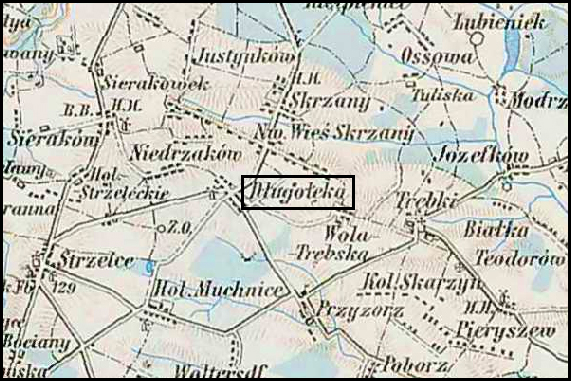
Austrian Military Map of Długołęka (5)

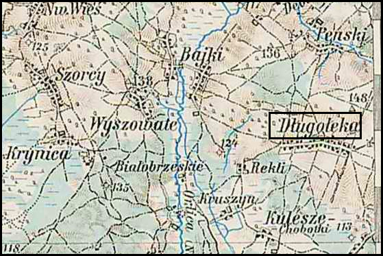
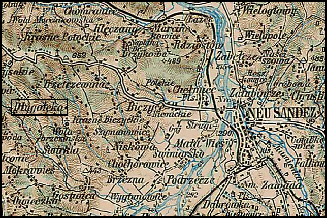
Of the six places called Długołęka in the Słownik Geograficzny Królestwa Polskiego i Innych Krajów Słowiańskich (Geographical Dictionary of the Kingdom of Poland and other Slavonic Countries), the fifth is located in the Świerkli (Świrkli) gmina and appears on the third Military Mapping Survey of Austria-Hungary on Sheet 38-50, Krakkó .  This place is described as a hamlet and was located in Galicia, the Austrian Partition of Poland . Â  The Słownik Geograficzny entry for Długołęka was translated in a previous post.

Austrian Military Map of Długołęka (5) - 1910

Austrian Military Map of Długołęka (5) – 1910

SOURCE: Third Military Mapping Survey of Austria-Hungary, 38-50, Krakkó. Online http://lazarus.elte.hu/hun/digkonyv/topo/200e/38-50.jpg; downloaded 27 Dec 2010.

Copyright © 2010 by Stephen J. Danko

Posted in Daily Journal | Tagged , | Comments Off on Austrian Military Map of Długołęka (5)

Austrian Military Map of Długołęka (4)

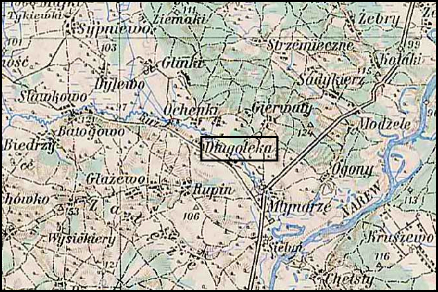
Of the six places called Długołęka in the Słownik Geograficzny Królestwa Polskiego i Innych Krajów Słowiańskich (Geographical Dictionary of the Kingdom of Poland and other Slavonic Countries), the fourth is located in the Maków Powiat and appears on the third Military Mapping Survey of Austria-Hungary on Sheet 39-53, Ostroleka .  This is a village of nobles and is also the village named Długołęka associated with my own ancestors . Â  The Słownik Geograficzny entry for Długołęka was translated in a previous post.

Austrian Military Map of Długołęka (4) - 1910

Austrian Military Map of Długołęka (4) – 1910

SOURCE: Third Military Mapping Survey of Austria-Hungary, 39-53, Ostroleka. Online http://lazarus.elte.hu/hun/digkonyv/topo/200e/39-53.jpg; downloaded 26 Dec 2010.

Copyright © 2010 by Stephen J. Danko

Posted in Daily Journal | Tagged , | Comments Off on Austrian Military Map of Długołęka (4)

Austrian Military Map of Długołęka (3)

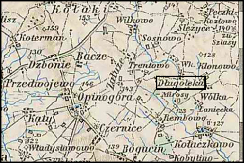
Of the six places called Długołęka in the Słownik Geograficzny Królestwa Polskiego i Innych Krajów Słowiańskich (Geographical Dictionary of the Kingdom of Poland and other Slavonic Countries), the third is located in the Ciechanów Powiat and appears on the third Military Mapping Survey of Austria-Hungary on Sheet 38-53, Mlawa .  This is a village of nobles . Â  The Słownik Geograficzny entry for Długołęka was translated in a previous post.

Austrian Military Map of Długołęka (3) - 1910

Austrian Military Map of Długołęka (3) – 1910

SOURCE: Third Military Mapping Survey of Austria-Hungary, 38-53, Mlawa. Online http://lazarus.elte.hu/hun/digkonyv/topo/200e/38-53.jpg; downloaded 25 Dec 2010.

Copyright © 2010 by Stephen J. Danko

Posted in Daily Journal | Tagged , | Comments Off on Austrian Military Map of Długołęka (3)

Austrian Military Map of Długołęka (2)

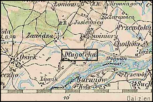
Of the six places called Długołęka in the Słownik Geograficzny Królestwa Polskiego i Innych Krajów Słowiańskich (Geographical Dictionary of the Kingdom of Poland and other Slavonic Countries), the second is located in the Sandomierz Powiat and appears on the third Military Mapping Survey of Austria-Hungary on Sheet 39-51, Radom .  This is the village on the Vistula River . Â  The Słownik Geograficzny entry for Długołęka was translated in a previous post.

Austrian Military Map of Długołęka (2) - 1910

Austrian Military Map of Długołęka (2) – 1910

SOURCE: Third Military Mapping Survey of Austria-Hungary, 39-51, Radom. Online http://lazarus.elte.hu/hun/digkonyv/topo/200e/39-51.jpg; downloaded 24 Dec 2010.

Copyright © 2010 by Stephen J. Danko

Posted in Daily Journal | Tagged , | Comments Off on Austrian Military Map of Długołęka (2)

Austrian Military Map of Długołęka (1)

Of the six places called Długołęka in the Słownik Geograficzny Królestwa Polskiego i Innych Krajów Słowiańskich (Geographical Dictionary of the Kingdom of Poland and other Slavonic Countries), the first is located in the Kutnow Powiat and appears on the third Military Mapping Survey of Austria-Hungary on Sheet 37-52, Lódż .  This was the village owned by a man named Józef Niedziałkowski .  The Słownik Geograficzny entry for Długołęka was translated in a previous post.

Austrian Military Map of Długołęka (1) - 1910

Austrian Military Map of Długołęka (1) – 1910

SOURCE: Third Military Mapping Survey of Austria-Hungary, 37-52, Lódż. Online http://lazarus.elte.hu/hun/digkonyv/topo/200e/37-52.jpg; downloaded 23 Dec 2010.

Copyright © 2010 by Stephen J. Danko

Posted in Daily Journal | Tagged , | Comments Off on Austrian Military Map of Długołęka (1)

The Polish Village of Długołęka

One of the places that appears in the records of verious relatives was Długołęka.  There are three major entries with a total of six records of places by this name in the Słownik Geograficzny Królestwa Polskiego i Innych Krajów Słowiańskich (Geographical Dictionary of the Kingdom of Poland and other Slavonic Countries). In addition, this record specifically mentions a Józef Niedziałkowski who owned one of this villages (I am conducting a one-name study on the Niedziałkowski surname).

Słownik Geograficzny Entry for Długołęka

Słownik Geograficzny Entry for Długołęka

Source:  Sulimierski, Filip, Bronisław Chlebowski, and Władysław Walewski, eds., Słownik Geograficzny Królestwa Polskiego i Innych Krajów Słowiańskich (Geographical Dictionary of the Kingdom of Poland and other Slavonic Countries) – Warsaw 1881, Volume II, page 039.

Click on the link for a PDF copy of the Słownik Geograficzny entry for Długołęka. Translated from the Polish, the entry reads:

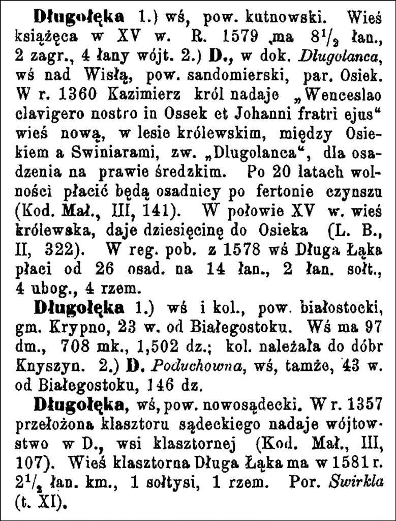
Długołęka  1.) a village in the Kutnow Powiat, Sójki Gmina, and Trąbki Parish.  37 włókas [a historical area measurement unit equal to 16.8 hectares] of arable land, a young forest of 10 włókas, and 359 residents. A beaten track leads 16 versts [0.66 miles per verst] to Kutny. Buildings with stonework and roofs of tile and asphalt. The base of the earth is clay and marl, and farming is prosperous and rational. There is a distillery. In the year 1827, there were 22 homes and 162 residents here, presently the count is 22 homes and 369 residents, there are 1440 morgs [in the Russian partition 1 morg = 1.388 acres] of general space, of which 1134 morgs are arable land, 120 morgs are forests, 60 morgs are meadows, and 126 morgs are the manor. The [unfenced?] Długołęka Starosty [district] came into existence at the beginning of the 17th century with the Gostyń Starosty. This village of Długołęka was assembled with a wójt and folwarks [large manorial farms]. In the year 1771, it was owned by Józef Niedziałkowski and he paid 282 Polish złoty for the quarter and 149 Polish złoty for hiberna [winter quarters for the military]. 2.) Długołęka, a village on the Vistula River in Sandomierz Powiat, Osiek Gmina and Parish. In the year 1827, there totaled 58 homes and 230 residents, currently there total 44 homes, 348 residents, and 503 morgs of land in the manor. It lies 29 versts from Sandomierz. 3.) Długołęka, a neighborhood of nobles in the Ciechanów Powiat, Bartołd Gmina, and Pałuki Parish. Within its limits lie the villages: Długołęka-Gębale, Długołęka-Mirosy (in the year 1827 there were 3 homes and 26 residents), Długołęka-Ossyski or -Osepki (in the year 1827 there were 5 homes and 221 residents), and  Długołęka-Wielka (in the year 1827 there were 12 homes and 69 residents). This last one lies in the Sońsk Parish on the Sona Creek and it totals 100 residents, 9 residential buildings, and an area of 250 morgs of which 228 is arable land. The Długołęka-Mirosy folwark has an area of 122 morgs, namely: 101 morgs of arable land and gardens, 10 morgs of meadows, 3 morgs of unused land and building lots. There are 6 wooden structures. 4.) Długołęka-kaski and Długołęka-wielka, villages in the Maków Powiat and the Sielun Gmina and Parish. Długołęka-kaski  (in the year 1827 there were 6 homes and 30 residents); Długołęka-wielka (in the year 1827 there were 17 homes and 84 residents).
Bronisław Chlebowski and Władysław Walewski

Długołęka, a hamlet in the Świerkli (Świrkli) Gmina.

Długołęka, a village in the Krotoszyn Powiat with 43 homes, 316 residents, 143 Evangelical Lutherans, 173 Roman Catholics, 121 illiterate persons. The post office is about 5 kilometers away in Kobylin; the railroad station is about 20 kilometers away in Krotoszyn.
Michał Studniarski

For the 1910 Austrian Military Maps of these six villages called Długołęka, see the following posts. The first four villages are numbered as in the entry above.  The hamlet in the Świerkli (Świrkli) Gmina is (5) and the village in the Krotoszyn Powiat is (6).

Copyright © 2010 by Stephen J. Danko

Posted in Daily Journal, Niedziałkowski | Tagged , | 3 Comments

The Polish Village of Gogole

One of the places that appear in the records of my Suwiński relatives was called Gogole.  There are two brief records of this village in the Słownik Geograficzny Królestwa Polskiego i Innych Krajów Słowiańskich (Geographical Dictionary of the Kingdom of Poland and other Slavonic Countries).

Austrian Military Map of the Gogole Area - 1910

Austrian Military Map of the Gogole Area – 1910

SOURCE: Third Military Mapping Survey of Austria-Hungary, Sheet 38-53, Mława. Online http://lazarus.elte.hu/hun/digkonyv/topo/200e/38-53.jpg; downloaded 21 Dec 2010.

Słownik Geograficzny Entry for Gogole

Słownik Geograficzny Entry for Gogole

Source:  Sulimierski, Filip, Bronisław Chlebowski, and Władysław Walewski, eds., Słownik Geograficzny Królestwa Polskiego i Innych Krajów Słowiańskich (Geographical Dictionary of the Kingdom of Poland and other Slavonic Countries) – Warsaw 1881, Volume II, pages 648-649.

Click on the link for a PDF copy of the Słownik Geograficzny entry for Gogole. Translated from the Polish, the entry reads:

     Gogole-wielkie and  Gogole-steczki, two villages in the Ciechanów Powiat, Gołymin Gmina, and Pałuki parish, about 13 versts from Ciechanów and about 5 versts from Pałuki. In 1827 Gogole-wielkie had 20 homes and 133 residents, while Gogole-steczki had 5 homes and 35 residents. Today, Gogole-wielkie has 19 homes, 210 residents, and 151 morgs [in the Russian partition 1 morg = 1.388 acres] of settlements, and Gogole-steczki has 9 homes, 61 residents, and 151 morgs of settlements. In the village of Gogole-wielkie there are a few larger folwarks [large manorial farms].
Gogole, see Dąbrowa, page 923.

Copyright © 2010 by Stephen J. Danko

Posted in Suwiński | Tagged | Comments Off on The Polish Village of Gogole

The Polish Village of Osyski

One of the places my Suwiński relatives lived was called Osyski .  There is a brief record of this village in the Słownik Geograficzny Królestwa Polskiego i Innych Krajów Słowiańskich (Geographical Dictionary of the Kingdom of Poland and other Slavonic Countries) which refers the reader to Długołęka, since the village is properly called Długołęka-Osyski.

Austrian Military Map of the Długołęka-Osyski Area - 1910

Austrian Military Map of the Długołęka-Osyski Area – 1910

SOURCE: Third Military Mapping Survey of Austria-Hungary, Sheet 38-53, Mława. Online http://lazarus.elte.hu/hun/digkonyv/topo/200e/38-53.jpg; downloaded 20 Dec 2010.

Słownik Geograficzny Entry for Osyski

Słownik Geograficzny Entry for Osyski

Source:  Chlebowski, Bronisław, Władysław Walewski, and Filip Sulimierski, eds., Słownik Geograficzny Królestwa Polskiego i Innych Krajów Słowiańskich (Geographical Dictionary of the Kingdom of Poland and other Slavonic Countries) – Warsaw 1886, Volume VII, page 749.

Click on the link for a PDF copy of the Słownik Geograficzny entry for Osyski. Translated from the Polish, the entry reads:

     Osyski, properly Długołęka-Osyski, a village on the Sona River, Ciechanów Powiat, Bartołd Gmina .  It has a nursery, an elementary school, and 188 morgs [in the Russian partition 1 morg = 1.388 acres] of territory .  In the year 1781 there were 21 residents here;  see Długołęka.

Copyright © 2010 by Stephen J. Danko

Posted in Suwiński | Tagged | Comments Off on The Polish Village of Osyski

The Polish Village of Bobin

I received a request from a reader named Louise for information about the Polish village of Bobin where she thinks her Bobiński ancestors originated .  I looked up information about the village in the gazetteer Słownik Geograficzny Królestwa Polskiego i Innych Krajów Słowiańskich (Geographical Dictionary of the Kingdom of Poland and other Slavonic Countries) and found two entries.

Słownik Geograficzny Entry for Bobin

Słownik Geograficzny Entry for Bobin

Source:  Source:  Sulimierski, Filip, Bronisław Chlebowski, and Władysław Walewski, eds., Słownik Geograficzny Królestwa Polskiego i Innych Krajów Słowiańskich (Geographical Dictionary of the Kingdom of Poland and other Slavonic Countries) – Warsaw 1880, Volume I, page 256.

Click on the link for a PDF copy of the Słownik Geograficzny entry for Bobin. Translated from the Polish, the entry reads:

     Bobin,  1.) a village on the Szreniawa [River], Pińczowski Powiat, Kościelec Gmina, Bobin Parish .  An extensive village halfway on the road from Proszowice to Koszyce .  It includes a stone parish church; there is a beautiful park of the estate on the Dzreniawa River, a shelter for brood hens and the lame (?), and an elementary school .  In the year 1827 there were 57 homes and 273 residents here .  The parish of Bobin belongs to the Pińczowski deanery and has a total of 1227 souls .  2.) Bobin- Mierzejewo, a village in the Ostrołęcki Powiat, Czwerwin Gmina, and Gaworowo Parish; the population of the manor is 58 and the extent is 120 morgs [in the Russian partition 1 morg = 1.388 acres].
                    Bronisław Chlebowski

Copyright © 2010 by Stephen J. Danko

Posted in Daily Journal | Tagged | Comments Off on The Polish Village of Bobin

Applying The Scientific Method to Genealogical Research (Part 8)

When does the use of The Scientific Method to conduct genealogical research fail to meet the Genealogical Proof Standard?

  1. Define the question:  When was Bronislawa (Bertha) Danko born?
  2. Gather information and resources:  Family members recall that Bronislawa (Bertha) Danko was born sometime around 1910-1915 in Worcester, Massachusetts.
  3. Form hypothesis:  Bronislawa (Bertha) Danko was born around 1910-1915.
  4. Perform experiment and collect data:  Search the birth records in the Massachusetts State Archives for Bronislawa (Bertha) Danko’s birth record.
  5. Analyze data:  Bronislawa Danko’s birth record was found in the Massachusetts State Archives and her date of birth was recorded as January 3, 1912.
  6. Interpret data and draw conclusions:  Bronislawa Danko was born on January 3, 1912.
  7. Publish results:  This information was communicated to family members and published on my blog.
  8. Retest:  To my knowledge, no retest has yet been performed.

The Scientific Method provided the answer to the question of when was Bronislawa (Bertha) Danko born .  This single iteration of The Scientific Method does not, however, satisfy the Genealogical Proof Standard because it does not include a reasonably exhaustive search and it does not resolve conflicting evidence.

Do other records agree with the date recorded in the records at the Massachusetts State Archives?  Bronislawa was probably baptized .  What is the date of birth on the baptismal record?  Does Bronislawa’s age at the time of her death agree with the date of her birth?  Was Bronislawa’s date of birth recorded in a birth announcement or obituary?  What other possible sources for Bronislawa’s date of birth might exist?

Bronislawa’s death certificate reported that she was born on January 2, 1912, not January 3, 1912 .  Which date is correct?

There are clearly more questions to answer here and more research to conduct before we can say that the Genealogical Proof Standard has been satisfied when stating that Bronislawa Danko was born on January 3, 1912.

The shortcomings of The Scientific Method may be remedied by posing new hypotheses such as:

  • Bronislawa (Bertha) Danko’s date of birth is included in her baptismal record or
  • Bronislawa (Bertha) Danko’s date of birth is mentioned in a birth announcement,

and by attempting to resolve the conflicting evidence.

The Scientific Method can help answer genealogical questions, but the researcher must still ensure that the conclusions drawn from The Scientific Method meet the Genealogical Proof Standard.

or other posts in this series, please see:

Copyright © 2010 by Stephen J. Danko

Posted in Dańko, Dziurzyński | Tagged | 3 Comments