The Second Birth of Walter William Dymek – 1912

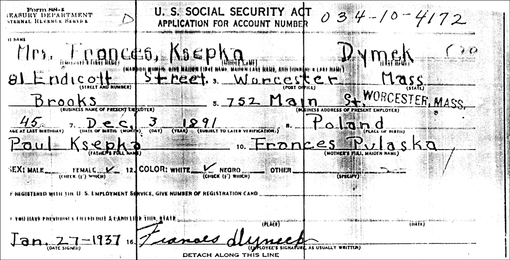
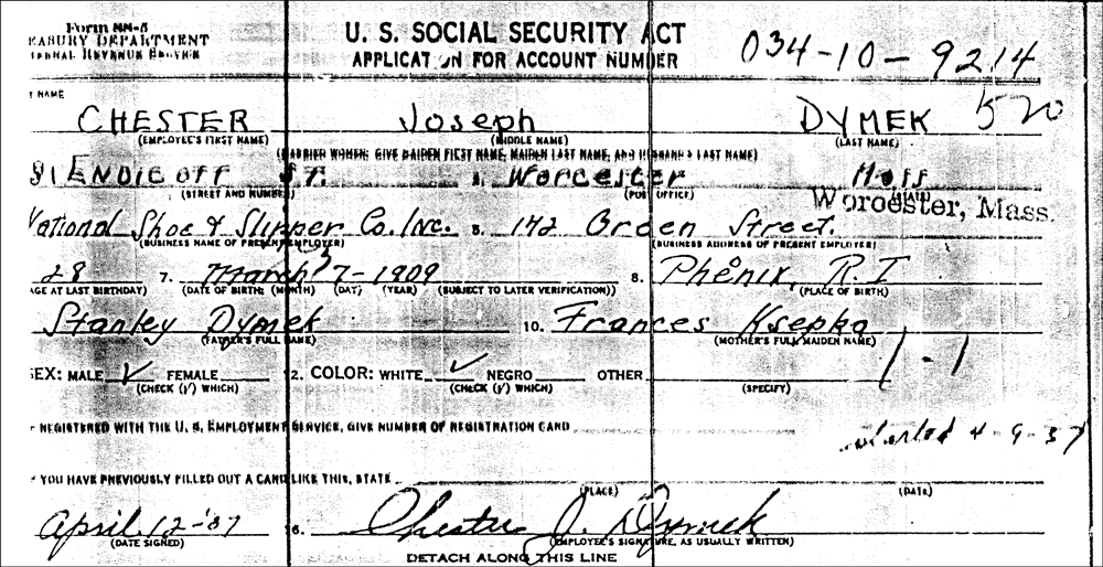
Walter William Dymek, son of Stanisław Dymek and Franciszka Ksepka, was born on 28 December 1911 in Worcester, Worcester County, Massachusetts, USA .  His birth was actually recorded twice in the ledgers for the city of Worcester. The first ledger was recorded in January 1912, shortly after his birth .  The second ledger was recorded in January 1913, over a year after his birth.

The Birth Record of Walter William Dymek - 1912

The Birth Record of Walter William Dymek – 1912

SOURCE:  “Massachusetts Vital Records, 1911-1915,” digital images, American Ancestors (http://www.americanancestors.org : accessed 15 February 2011), Birth of Vadislof Demick, vol. 608, page 488, no. 1970, Worcester, Massachusetts, 01 January 1912; citing Vital Records: 1841-1915, Massachusetts State Archives, Boston, Massachusetts.

The image above is a composite image from the ledger, cropped to emphasize the information for Walter William Dymek .  Click on the link for a PDF copy of the second birth record of Walter William Dymek .  The ledger states:

  • Walter William Dymek’s birth is recorded as No. 1970 in the ledger for the city of Worcester
  • His name is recorded as Waslav Dimick, a male child born in Worcester
  • He was born on 01 January 1912 and his birth was recorded in January 1913
  • His father was Sephen Dimick [Stanisław Dymek], a laborer from Russia Poland residing in Worcester
  • His mother was Frances Zipka [Franciszka Ksepka] from Russia Poland, residing in Worcester

As usual, the names in this record are badly misspelled, but the most startling thing is that Walter’s birth was recorded twice, reporting that he was born on 28 December 1911 in the first record and that he was born on 01 January 1912 in the second record .  He, himself, used the 28 December 1911 birthdate, which is the most reliable from the records since the 01 January 1912 date was recorded in the ledger over a year after his birth.

At the time of Walter’s birth, there was no requirement in Massachusetts for physicians and midwives to promptly report births to the town .  To ensure that all births in a town were properly recorded, canvassers asked local residents about births in their families and reported the results to the town .  Walter’s birth was recorded twice (under different spellings) probably because the family didn’t remember that they had already reported his birth in January 1912, and reported it again in January 1913.

Copyright © 2011 by Stephen J. Danko

Posted in Dymek, Ksepka | Tagged | Comments Off on The Second Birth of Walter William Dymek – 1912

The Birth of Walter William Dymek – 1911

Walter William Dymek, son of Stanisław Dymek and Franciszka Ksepka, was born on 28 December 1911 in Worcester, Worcester County, Massachusetts, USA .  His birth was recorded in a ledger for the city of Worcester where his name was spelled Vadislof (Władysław) Demick.

The Birth Record of Walter William Dymek - 1911

The Birth Record of Walter William Dymek – 1911

SOURCE:  “Massachusetts Vital Records, 1911-1915,” digital images, American Ancestors (http://www.americanancestors.org : accessed 14 February 2011), Birth of Vadislof Demick, vol. 600, page 488, no. 975, Worcester, Massachusetts, 28 December 1911; citing Vital Records: 1841-1915, Massachusetts State Archives, Boston, Massachusetts.

The image above is a composite image from the ledger, cropped to emphasize the information for Walter William Dymek.  Click on the link for a PDF copy of the birth record of Walter William Dymek .  The ledger states:

  • Walter Willliam Dymek’s birth is recorded as No. 975 in the ledger for the city of Worcester,
  • His name is recorded as Vadlislof Demick, a male child born in Worcester,
  • He was born on 28 December 1911 and his birth was recorded in January 1912,
  • His father was Stephen Demick [Stanisław Dymek], a laborer from Russia residing in Worcester,
  • His mother was Frances Skepka [Franciszka Ksepka] from Russia, residing in Worcester.

The names in this record are badly misspelled, but misspellings are typical in Massachusetts vital records from this time period.

Copyright © 2011 by Stephen J. Danko
Posted in Dymek, Ksepka | Tagged | Comments Off on The Birth of Walter William Dymek – 1911

Map of the Polish Village of Piasutno (Kolno Powiat)

Of the two places called Piasutno in the Słownik Geograficzny Królestwa Polskiego i Innych Krajów Słowiańskich (Geographical Dictionary of the Kingdom of Poland and other Slavonic Countries), the first is located in the Kolno Powiat .  The village of Piasutno is named on the Third Military Mapping Survey of Austria-Hungary as Piasutno itself, as Poreby-Piasutno and as Ludwy-Piasutno .  Piasutno is in the Gawrychy Gmina, but Ludwy-Piasutno is probably in the Czerwone Gmina, based on its location relative to other villages (Gietki and Niksowizna) in the Czerwone Gmina. Piasutno is in the Mały Płock Parish, as are Gietki and Niksowizna .  The Słownik Geograficzny entry for Piasutno was translated in a previous post.

Austrian Military Map of the Piasutno Area - 1910

Austrian Military Map of the Piasutno Area – 1910

SOURCE: Third Military Mapping Survey of Austria-Hungary, Sheet 39-53, Ostroleka and Sheet 40-53, Lomża. Online http://lazarus.elte.hu/hun/digkonyv/topo/200e/39-53.jpg and http://lazarus.elte.hu/hun/digkonyv/topo/200e/40-53.jpg; downloaded 09 Feb 2011.

I am interested in the village of Piasutno because I am trying to find the name of the parish to which belonged the village of Dymki, the ancestral home of my Dymek cousins .  Most records state that the Dymeks were from the village of Dymki, but one stated that the name of the village was Peosutno Dymki .  So far, all the research indicates that the village of Dymki belonged to either the Kolno Parish or the neighboring Mały Płock Parish in the Kolno Powiat, Łomża Gubernia.

Copyright © 2011 by Stephen J. Danko
Posted in Dymek | Tagged , | Comments Off on Map of the Polish Village of Piasutno (Kolno Powiat)

Map of the East Prussian Village of Piasutten (Piasutno)

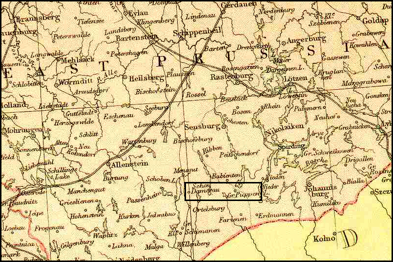
Of the two places called Piasutno in the Słownik Geograficzny Królestwa Polskiego i Innych Krajów Słowiańskich (Geographical Dictionary of the Kingdom of Poland and other Slavonic Countries), the second is located in the what the Słownik Geograficzny calls the Szczytno Powiat .  The village of Piasutno (Piasutten in German) is not named on a map of East Prussia from 1882, but it is located about halfway between Schon Damerau and Gr. Puppen .  Today, Schon Damerau is called Trelkowo and Gr. Puppen is called Spychowo .  The Słownik Geograficzny entry for Piasutno was translated in a previous post.

Map of the Piasutno Area - 1882

Map of the Piasutno Area – 1882

SOURCE:  Blackie & Son Atlas (Edinburgh, 1882), “German Empire, East Prussia 1882”; digital image, The Federation of East European Family History Societies, FEEFHS Map Library
(http://www.feefhs.org/maplibrary/german/ge-eprus.html : accessed 12 Feb 2011).

Of interest to me is the proximity of this village to Schon Damerau (or Gross Schöndamerau, or Trelkowo) .  My grand uncle Józef Niedziałkowski was married twice, both times in Gross Schöndamerau in the interwar years when the area was still under German control.

Copyright © 2011 by Stephen J. Danko
Posted in Daily Journal | Tagged , | 3 Comments

The Polish and Prussian Villages of Piasutno

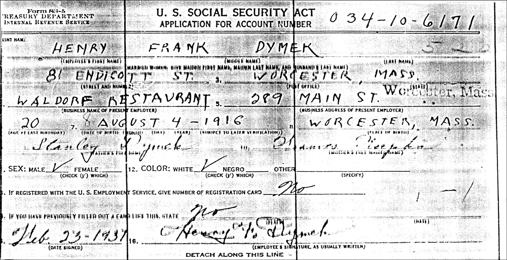
Several of my cousins descend from Józef Dymek of Dymki, Kolno, Łomża in Poland .  The Słownik Geograficzny Królestwa Polskiego i Innych Krajów Słowiańskich (Geographical Dictionary of the Kingdom of Poland and other Slavonic Countries) lists three villages called Dymki, but the one that matches this location, the first in the Słownik Geograficzny entry, does not provide the location of the parish where the records would be located .  A search for the surname Dymek in the World War II draft registrations revealed that a Stanislaw Dymek was from Peosutno Dymki, which I believe may either be the same village for which I am looking or may be another village nearby .  Two villages called Piasutno are described in the Słownik Geograficzny.

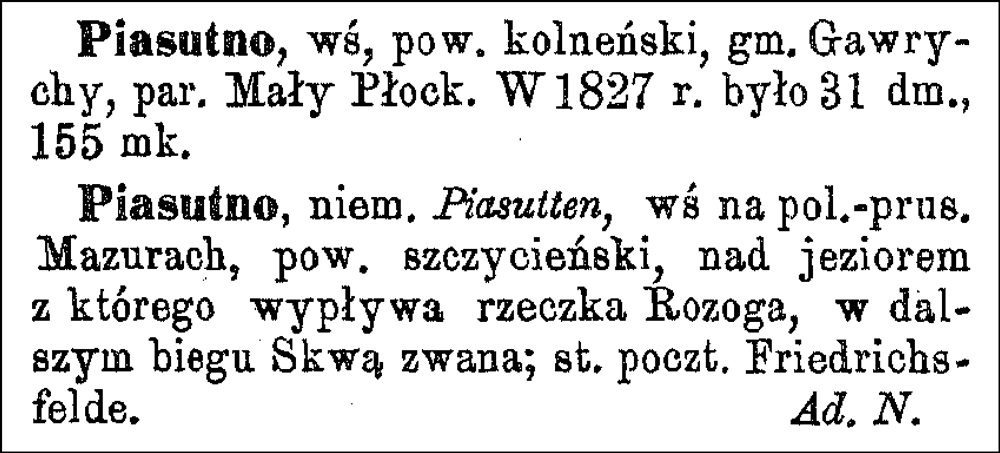
Słownik Geograficzny Entry for Piasutno

Słownik Geograficzny Entry for Piasutno

SOURCE:  Chlebowski, Bronisław, Władysław Walewski, and Filip Sulimierski, eds., Słownik Geograficzny Królestwa Polskiego i Innych Krajów Słowiańskich (Geographical Dictionary of the Kingdom of Poland and other Slavonic Countries) – Warsaw 1887, Volume VIII, page 060.

Click on the link for a PDF copy of the Słownik Geograficzny Entry for Piasutno. Translated from the Polish, the entry reads:

  Piasutno,  a village in the Kolno Powiat, Gawrychy Gmina, and Mały Płock Parish .  In the year 1827 there were 31 homes and 155 residents.
  Piasutno, Piasutten in German, a village in Polish-Prussian Masuria, Szczytno Powiat, on the lake [Piasutno Lake] from which the Rozoga River flows .  Downstream it is called the Szkwa River .  The post office is in Friedrichsfelde [now called Chochół] . Â Â Adam Napieralski

The relevant village is the first one mentioned in the Słownik Geograficzny. The second is located in the territory seized by Prussia in the First Partition of Poland and was incorporated into East Prussia .  If Dymki was the same as Peosutno Dymki or nearby, Dymki may have belonged to the parish of Mały Płock.

For a map of the area around Piasutno, Kolno Powiat (the first entry), see the article Map of the Polish Village of Piasutno (Kolno Powiat) .

For a map of the area around Piasutno, Szczytno Powiat (the second entry), see the article Map of the East Prussian Village of Piasutten (Piasutno) .

Copyright © 2011 by Stephen J. Danko

Posted in Dymek | Tagged | 1 Comment

The World War II Draft Registration Card for Stanislaw Dymek

While trying to find information on where in Poland the family of Józef Dymek originated, I learned that the family came from Dymki, Kolno (Powiat), Łomża (Gubernia) .  However, there is no indication of the name of the parish where the records for Dymki were maintained .  The Słownik Geograficzny Królestwa Polskiego i Innych Krajów Słowiańskich (Geographical Dictionary of the Kingdom of Poland and other Slavonic Countries) only states that this village of Dymki was in the Czerwone Gmina .  The villages in the Czerwone Gmina, Kolno Powiat, Łomża Gubernia belonged to one of three parishes:  Kolno, Lachowo, or Mały Płock .  Which of these is the correct parish for Dymki?  To try to narrow the search further, I looked through the World War I and World War II draft cards for men in Massachusetts with the surname Dymek (or some variant) .  One such card contained some interesting information.

The World War II Draft Card for Stanislaw Dymek - Obverse

The World War II Draft Card for Stanislaw Dymek – Obverse

SOURCE:  “U.S. World War II Draft Registration Cards, 1942,” digital images, Ancestry.com (http://www.ancestry.com : accessed 9 February 2011), Stanislaw Dymek, serial no. 0500, order no. not provided, Draft Board 82, Lee, Berkshire County, Massachusetts; citing United States, Selective Service System. Selective Service Registration Cards, World War II: Fourth Registration, NARA microfilm publication M2090; roll 46.

The World War II Draft Card for Stanislaw Dymek - Reverse

The World War II Draft Card for Stanislaw Dymek – Reverse

SOURCE:  “U.S. World War II Draft Registration Cards, 1942,” digital images, Ancestry.com (http://www.ancestry.com : accessed 9 February 2011), Stanislaw Dymek, serial no. 0500, order no. not provided, Draft Board 82, Lee, Berkshire County, Massachusetts; citing United States, Selective Service System. Selective Service Registration Cards, World War II: Fourth Registration, NARA microfilm publication M2090; roll 46.

I don’t know who this Stanislaw Dymek is or whether he connects into the family I’m researching .  However, he listed his place of birth as Peosutno Dymki, which is a promising lead for the family of interest .  I have not found the village of Dymki on a map, and the Słownki Geograficzny lists no parish for Dymki .  However, the village of Piasutno does appear on maps in the right area, and the Słownik Geograficzny does have an entry for Piasutno .  Perhaps this clue will help me find the correct parish for the Dymeks.

Copyright © 2011 by Stephen J. Danko
Posted in Dymek | Tagged | Comments Off on The World War II Draft Registration Card for Stanislaw Dymek

The Polish Village and Gmina of Czerwone

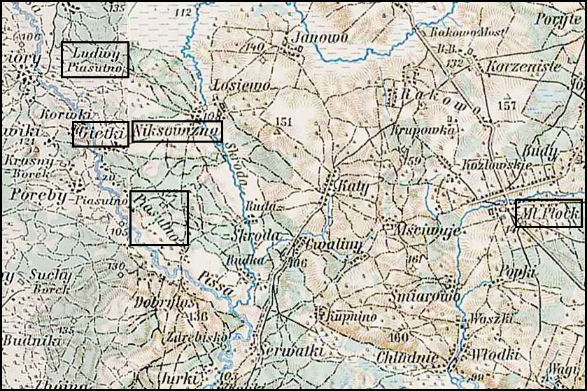
Several of my cousins descend from Józef Dymek of Dymki, Kolno, Łomża in Poland .  The Słownik Geograficzny Królestwa Polskiego i Innych Krajów Słowiańskich (Geographical Dictionary of the Kingdom of Poland and other Slavonic Countries) lists three villages called Dymki, but the one that matches this location, the first in the Słownik Geograficzny entry, does not provide the location of the parish where the records would be located .  The entry does, however, mention that the village was in the Czerwone Gmina .  I looked up Czerwone in the Słownik Geograficzny and found a description of both the village and the Gmina of that name .  The map below is a composite image of the Czerwone Gmina generated from two of the Austrian Military Maps from 1910 .  The vilages that belong to the Czerwone Gmina are highlighted in black boxes .  A few villages belonging to the Gmina are not on this map, but are located to the south of the area shown.

Austrian Military Map of the Czerwone Gmina - 1910

Austrian Military Map of the Czerwone Gmina – 1910

SOURCE: Third Military Mapping Survey of Austria-Hungary, Sheet 39-53, Ostroleka and Sheet 40-53, Lomża. Online http://lazarus.elte.hu/hun/digkonyv/topo/200e/39-53.jpg and http://lazarus.elte.hu/hun/digkonyv/topo/200e/40-53.jpg; downloaded 08 Feb 2011.

Słownik Geograficzny Entry for Czerwone

Słownik Geograficzny Entry for Czerwone

SOURCE:  Sulimierski, Filip Chlebowski, Bronisław, and Władysław Walewski, eds., Słownik Geograficzny Królestwa Polskiego i Innych Krajów Słowiańskich (Geographical Dictionary of the Kingdom of Poland and other Slavonic Countries) – Warsaw 1880, Volume I, page 841.

Click on the link for a PDF copy of the Słownik Geograficzny Entry for Czerwone. Translated from the Polish, the entry reads:

  Czerwone, a village and governmental folwark [a large manorial farmstead] in the Kolno Powiat, Czerwone Gmina, and Kolno Parish .  It lies about 3 versts [0.66 miles per verst] to the northwest of Kolno by a beaten path to the Wincenta storehouse .  The Serafiec Lake and two others are here .  In the year 1827, Czerwone counted 94 homes and 638 residents, currently there are 90 homes, 977 residents, and 3355 morgs [in the Russian partition 1 morg = 1.388 acres] of land. The Czerwone Gmina has a population of 5139 and an expanse of 10194 morgs;  the Gmina office is in the village of Zabiele, the Gmina court for the second district is in Mały Płock, and the post office is in Kolno .  It has a distillery, an alcohol treatment plant, a brewery, two brickyards, two mills, and a peat pit .  There are three elementary schools .  The Gmina consists of 4 villages of the nobility: Gromadzyn-Wykno, Gromadzyn-stary, Pachuczyn i Tyszki łabno;  also 20 peasant villages:  Chaberki, Czarnice, Czerwone, Dudy-nadrzeczne, Dymki, Gietki, Gorszczyzna, Jarubin, Kozioł, Kołymagi, Ludny, Nikrowizna, Ptaki, Pryski, Tupin, Samule, Ważki, Wincenta, Zabiele and Żelazne.
          Bronisław Chlebowski

Most of the villages in the gmina belong to the parish in Kolno .  Wincenta belongs to the parish in Lachowo to the north. Gietki, Niksowizna, and Zelazne belong to the parish in Mały Płock to the south.

With this information, it appears that Dymki probably belonged to one of three parishes: Kolno, Lachowo, or Mały Płock.

Copyright © 2011 by Stephen J. Danko

Posted in Daily Journal | Tagged | Comments Off on The Polish Village and Gmina of Czerwone

Map of the Belarusian Village of Borysov

Of the three places called Dymki in the Słownik Geograficzny Królestwa Polskiego i Innych Krajów Słowiańskich (Geographical Dictionary of the Kingdom of Poland and other Slavonic Countries), the third is located in the Borysów Powiat, now located in Belarus .  Although the village of Dymki does not appear on the 1834 Map of Minsk Gubernia, Dymki was adjacent to Borysov, and Borysov is clearly shown on this map .  The Słownik Geograficzny entry for Dymki was translated in a previous post.

Map of the Borysov Area - 1834

Map of the Borysov Area – 1834

SOURCE: 1834 Map of Minsk Gubernia. Online http://www.jewishgen.org/belarus/1834_minsk_gubernia_map.htm; downloaded 07 Feb 2011.

A search on Wikipedia reveals that Napoleon’s army lost about 36,000 men when trying to cross the Berezina River, confirming that this is the site of the former village of Dymki .  The third Słownik Geograficzny entry for Dymki states that “In the year 1812 on the last day of November, this place was witness to a terrible battle at the time of the retreat of the French .  It was turned to ashes.”

Copyright © 2011 by Stephen J. Danko

Posted in Daily Journal | Tagged | Comments Off on Map of the Belarusian Village of Borysov

Map of the Polish Village of Dymki (Wielun Powiat)

Of the three places called Dymki in the Słownik Geograficzny Królestwa Polskiego i Innych Krajów Słowiańskich (Geographical Dictionary of the Kingdom of Poland and other Slavonic Countries), the second is located in the Wielun Powiat and appears on the third Military Mapping Survey of Austria-Hungary on Sheet 36-51, Opole .  The Słownik Geograficzny entry for Dymki was translated in a previous post.

Austrian Military Map of Dymki (2) - 1910

Austrian Military Map of Dymki (2) – 1910

SOURCE: Third Military Mapping Survey of Austria-Hungary, 36-51, Opole. Online http://lazarus.elte.hu/hun/digkonyv/topo/200e/36-51.jpg; downloaded 07 Feb 2011.

Copyright © 2011 by Stephen J. Danko

Posted in Daily Journal | Tagged | Comments Off on Map of the Polish Village of Dymki (Wielun Powiat)

The Polish and Belarusian Villages of Dymki

Several of my cousins are descended from Józef Dymek .  Rercently, I learned that the Dymeks came from Dymki, Kolno (Powiat?), Łomża (Gubernia?) .  There are brief records of three villages by this name in the Słownik Geograficzny Królestwa Polskiego i Innych Krajów Słowiańskich (Geographical Dictionary of the Kingdom of Poland and other Slavonic Countries).

Słownik Geograficzny Entris for Dymki

Słownik Geograficzny Entry for Dymki

SOURCE:  Sulimierski, Filip Chlebowski, Bronisław, and Władysław Walewski, eds., Słownik Geograficzny Królestwa Polskiego i Innych Krajów Słowiańskich (Geographical Dictionary of the Kingdom of Poland and other Slavonic Countries) – Warsaw 1881, Volume II, page 251.

Click on the link for a PDF copy of the Słownik Geograficzny Entry for Dymki. Translated from the Polish, the entry reads:

  Dymki 1.) a Kurpie village in the Kolno Powiat, Czerwone Gmina. Peasants own 136 morgs [in the Russian partition 1 morg = 1.388 acres] of land, of which 70 are arable .  2.) Dymki, a hamlet in the Czarnożylski estate, Wielun Powiat, Lututów Gmina and Parish; about 3 milas [7 versts per mila] from Wielun, about 4 versts [0.66 miles per verst] from Lututów, on the border of the Sieradz Powiat .  It has 12 homes, 100 residents, 3 morgs of peasant land .  The area of the manor is 53 włókas [30 morgs per włóka] (in which there are 20 włókas of arable land, 6 włókas of meadows, and 25 włókas of forests), there is an active distillery with machinery of old construction; there is a windmill .  In the year 1827 there were 13 homes and 105 residents here. W…r.

  Dymki, a little village in the Borysów Powiat [now in Belarus], across the town of Borysów on the right side of the Berezyna River .  In the year 1812 on the last day of November, this place was witness to a terrible battle at the time of the retreat of the French .  It was turned to ashes.
 Aleksander Jelski

Copyright © 2011 by Stephen J. Danko
Posted in Dymek | Tagged | Comments Off on The Polish and Belarusian Villages of Dymki