
The Słownik Geograficzny Królestwa Polskiego i Innych Krajów Słowiańskich (Geographical Dictionary of the Kingdom of Poland and other Slavonic Countries) does not include an entry for the village of Śliwnica in Dubiecko Parish. Furthermore, the Dictionary of Polish Place Names (Nazwy Miejscowe Polski) that would include an entry for Śliwnica has not yet been published.

Ritter, Karl. 1855. “Administrativ-Karte von Den Königreichen Galizien und Lodomerien.” Wien: Verlag und Eigenthum von Artaria & Co.; digital images, Polona (https://polona.pl/item-view/9341ec1b-5a4b-44a5-9f6b-a22c716faf46?page=36: accessed 30 November 2025)
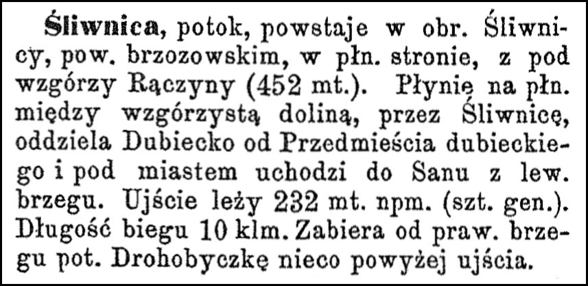
There is, however, an entry in the Słownik Geograficzny Królestwa Polskiego i Innych Krajów Słowiańskich for the Śliwnica stream which flows through Śliwnica and Dubiecko, and this entry is shown here.
Source: Chlebowski, Bronisław, Władysław Walewski, and Filip Sulimierski, eds., Słownik Geograficzny Królestwa Polskiego i Innych Krajów Słowiańskich (Geographical Dictionary of the Kingdom of Poland and other Slavonic Countries) – Warsaw 1889, Volume X, page 767.
Click on the link for a PDF copy of the second Słownik Geograficzny entry for Śliwnica, potok. Translated from the Polish, the entry reads:
Śliwnica, a stream, rises in the vicinity of Śliwnica, Brzozów County, on the northern side, from under the Rączyna hills (452 mt). It flows northward between a hilly valley, through Śliwnica, separates Dubiecko from Przedmieście Dubiecko and flows into the San River on the left bank near the city. Its mouth lies 232 meters above sea level (general height). The length of its course is 10 km. It takes in the Drohobyczka Stream from its right bank, slightly above its mouth.
Copyright © 2025 by Stephen J. Danko


