The Polish Villages of Zbiki

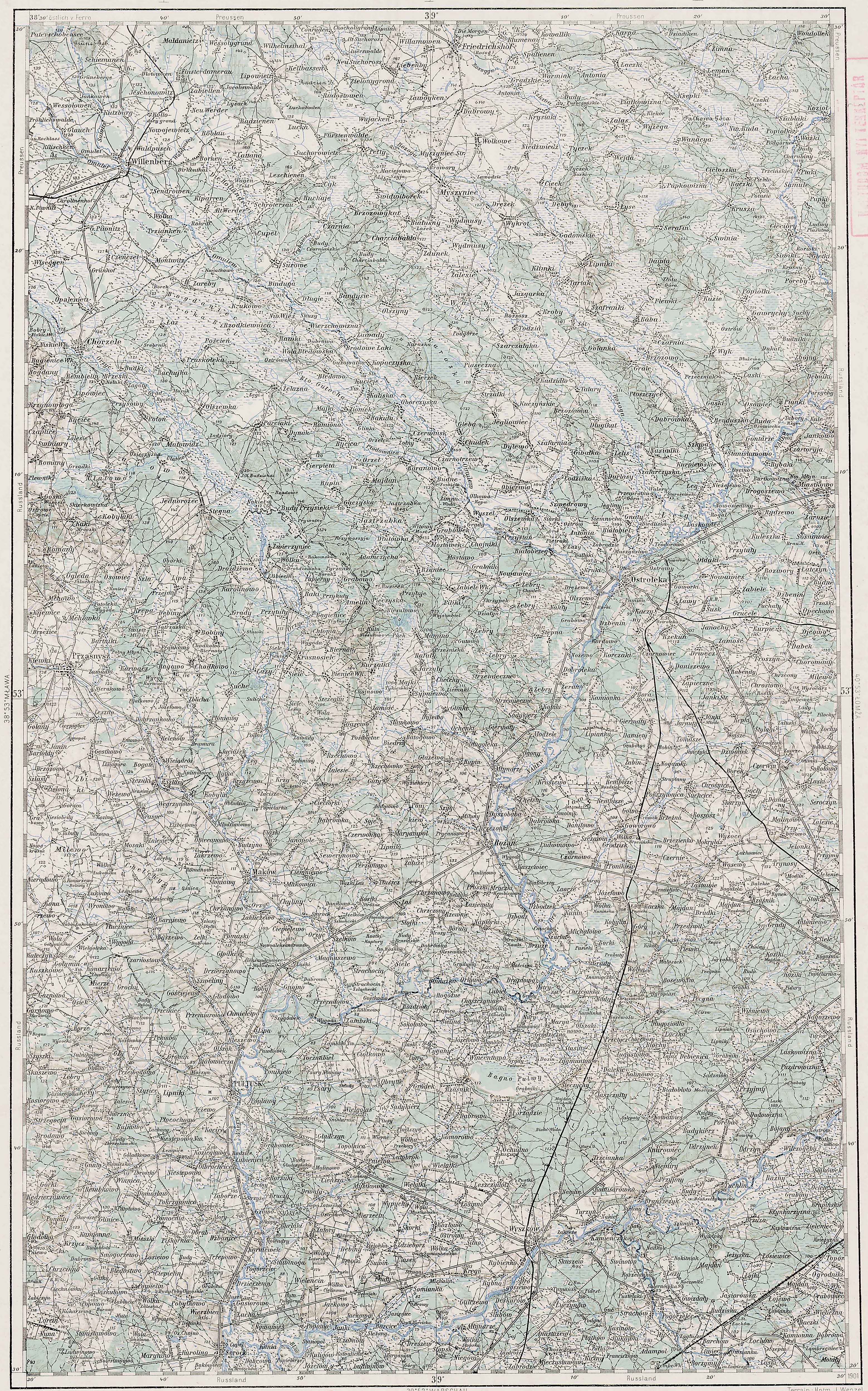
The villages of Zbiki are significant in my family history because they were locations where some of my Chodkowski cousins lived. In particular, some of my Chodkowski cousins lived in Zbiki Gawronki and Zbiki Kierzki.

Austrian Military Map of the Zbiki Area - 1910

Austrian Military Map of the Zbiki Area – 1910

SOURCE: Third Military Mapping Survey of Austria-Hungary, Sheet 39-53, Ostrolecka. Online http://lazarus.elte.hu/hun/digkonyv/topo/200e/39-53.jpg; downloaded 22 May 2010.

Słownik Geograficzny Entry for Zbiki

Słownik Geograficzny Entry for Zbiki

Source:  Chlebowski, Bronisław, Józef Krzywicki, Filip Sulimierski, and Władysław Walewski, eds., Słownik Geograficzny Królestwa Polskiego i Innych Krajów Słowiańskich (Geographical Dictionary of the Kingdom of Poland and other Slavonic Countries) – Warsaw 1895, Volume XIV, page 518.

Click on the link for a PDF copy of the Słownik Geograficzny entry for Zbiki. Translated from the Polish, the entry reads:

Zbiki 1.) in the 16th century, Zdbiki, a village in the Żegocin Parish (Kalisz Powiat), see Żbiki. 2.) Zbiki, in the 16th century Zdbyki, the name of an area in the Ciechanów Powiat, Zalesie Gmina, and Krasne Parish, 24 versts [0.66 miles per verst] from Ciechanów. In this area the following villages and granges [large manorial farmsteads] are found:  Zbiki Antosy, a village that has 6 homes, 54 residents, and 185 morgs [in the Russian partition 1 morg = 1.388 acres]. A few nobles live here. In the year 1827 there were 8 homes and 61 residents. Zbiki Gawronki, a village that has 8 homes, 82 residents, and 210 morgs. A few nobles live here. In the year 1827 there were 11 homes and 66 residents. Zbiki Kierzki, a village that has 12 homes, 91 residents, and 308 morgs. A few nobles live here. In the year 1827 there were 8 homes and 54 residents. Zbiki Starki, a grange that has 2 homes, 22 residents, and 140 morgs. It belongs to the property of Krasne. In the year 1827 there were 2 homes, 11 residents. Zbiki Wielkie, a grange and village that had 14 homes, 63 residents, and 910 morgs in the grange, 41 morgs in the manor. The grange belongs to the property of Augustów in the domain of Krasne. In the year 1827 there were 20 homes and 150 residents. In the year 1567 Zdbyki Antoni had 4 włóki [1 włóka = 16.8 hectares]; Zbiki Gawronki had 5 divisions of ½ włóka, 10 morgs, and 1 garden; Zbiki Janusze has 1 włóka, 6 morgs, and 2 parts of ¼ włóka; Zbiki Stara Wieś had 3 włóki, 3 divisions of ½ włoka, 7 parts of 1 włóka, 10 craftsmen, 3 włóki, 9 craftsmen; Zbiki Karpieta (Wielkie) ½ włóka and 2 parts of 3/8 włóka (Pawiński, Mazowsze, 345).The place labeled as 2.) in this entry is the one in which my cousins resided.

The notation (Pawiński, Mazowsze, 345) refers to:

Pawiński, Adolf. 1892. Mazowsze. Polska XVI wieku pod względem geograficzno-statystycznym, t. 5. Warszawa: skł. gł. w Księgarni Gebethnera i Wolffa.

This publication is available online at the Digital Library of Wielkopolska.

The maps of the Third Military Mapping Survey of Austria-Hungary and the entries in the Słownik Geograficzny were prepared at about the same time and make a good pair for studying places in and around the Congress Kingdom of Poland at the end of the 19th century and beginning of the 20th century, a time period when the Eastern European ancestors of present-day Americans left their homelands for the United States.

Copyright © 2010 by Stephen J. Danko

Posted in Chodkowski | Tagged , | Comments Off on The Polish Villages of Zbiki

The Polish Village of Zakrzewo

The village of Zakrzewo is significant in my family history because it was the location where some of my Chodkowski cousins were born.

Austrian Military Map of the Zakrzewo Area - 1910

Austrian Military Map of the Zakrzewo Area – 1910

SOURCE: Third Military Mapping Survey of Austria-Hungary, Sheet 39-53, Ostrolecka. Online http://lazarus.elte.hu/hun/digkonyv/topo/200e/39-53.jpg; downloaded 21 May 2010.

Słownik Geograficzny Entry for Zakrzewo

Słownik Geograficzny Entry for Zakrzewo

Source:  Chlebowski, Bronisław, Józef Krzywicki, Filip Sulimierski, and Władysław Walewski, eds., Słownik Geograficzny Królestwa Polskiego i Innych Krajów Słowiańskich (Geographical Dictionary of the Kingdom of Poland and other Slavonic Countries) – Warsaw 1895, Volume XIV, page 319.

Click on the link for a PDF copy of the Słownik Geograficzny entry for Zakrzewo. Translated from the Polish, the entry reads:

11.) Zakrzewo, a village and grange [large manorial farmstead] in the Maków Powiat, Karniewo Gmina, and Maków Parish (4 versts distant) versts [0.66 miles per verst]. In the year 1885, the Zakrzewo grange extended 206 morgs [in the Russian partition 1 morg = 1.388 acres]: 167 morgs of [arable] land and gardens, 20 morgs of meadows, 12 morgs of pastures, 8 morgs of wastelands. There are 7 wooden buildings. The village of Zakrzewo includes 4 settlements and 5 morgs.

The place described in this entry is only one of at least 37 places in Poland called Zakrzewo.

The maps of the Third Military Mapping Survey of Austria-Hungary and the entries in the Słownik Geograficzny were prepared at about the same time and make a good pair for studying places in and around the Congress Kingdom of Poland at the end of the 19th century and beginning of the 20th century, a time period when the Eastern European ancestors of present-day Americans left their homelands for the United States.

Copyright © 2010 by Stephen J. Danko

Posted in Chodkowski | Tagged , | 1 Comment

The Polish Village of Wężewo

The village of Wężewo is significant in my family history because it was the location where the spouses of some distant Chodkowski relatives lived.

Austrian Military Map of the Wężewo Area - 1910

Austrian Military Map of the Wężewo Area – 1910

SOURCE: Third Military Mapping Survey of Austria-Hungary, Sheet 39-53, Ostrolecka. Online http://lazarus.elte.hu/hun/digkonyv/topo/200e/39-53.jpg; downloaded 20 May 2010.

Słownik Geograficzny Entry for Wężewo

Słownik Geograficzny Entry for Wężewo

Source:  Chlebowski, Bronisław, Filip Sulimierski, and Władysław Walewski, eds., Słownik Geograficzny Królestwa Polskiego i Innych Krajów Słowiańskich (Geographical Dictionary of the Kingdom of Poland and other Slavonic Countries) – Warsaw 1893, Volume XIII, page 113.

Click on the link for a PDF copy of the Słownik Geograficzny entry for Wężewo. Translated from the Polish, the entry reads:

Wężewo, a village in Ciechanów Powiat, Zalesie Gmina, and Bogate Parish, 25 versts [0.66 miles per verst] from Ciechanów. It has 21 homes, 184 residents, and 453 morgs morgs [in the Russian partition 1 morg = 1.388 acres] of land (9 morgs of wastelands); a clearcut settlement belonging to the property of Augustów. In the year 1567, the village of Wężewo in the Bogate Parish consisted of 4 parts, having from 2 ½ to 3 ½ włóki [1 włóka = 16.8 hectares] (Pawiński, Mazowsze, 347). In the year 1827 there were 12 homes and 112 residents. It belonged to the Krasne Parish.

The reference to Pawiński, Mazowsze, 347 refers to:

Pawiński, Adolf. 1892. Mazowsze. Polska XVI wieku pod względem geograficzno-statystycznym, t. 5. Warszawa: skł. gł. w Księgarni Gebethnera i Wolffa.

This publication is available online at the Digital Library of Wielkopolska.

Note that the village of Wężewo belonged to the Krasne Parish in 1827, but belonged to the Bogate Parish in 1567. The Słownik Geograficzny entry inplies that Wężewo belonged to the Bogate Parish at the time the Słownik was written (1893), but a search of Internet resources show that, today, Wężewo belongs to the Krasne Parish.

The maps of the Third Military Mapping Survey of Austria-Hungary and the entries in the Słownik Geograficzny were prepared at about the same time and make a good pair for studying places in and around the Congress Kingdom of Poland at the end of the 19th century and beginning of the 20th century, a time period when the Eastern European ancestors of present-day Americans left their homelands for the United States.

Copyright © 2010 by Stephen J. Danko

Posted in Chodkowski | Tagged , , | Comments Off on The Polish Village of Wężewo

The Polish Village of Niesiobędy

The village of Niesiobędy is significant in my family history because it was the location where some distant Grabowski relatives lived.

Austrian Military Map of the Niesiobędy Area - 1910

Austrian Military Map of the Niesiobędy Area – 1910

SOURCE: Third Military Mapping Survey of Austria-Hungary, Sheet 39-53, Ostrolecka. Online http://lazarus.elte.hu/hun/digkonyv/topo/200e/39-53.jpg; downloaded 19 May 2010.

Słownik Geograficzny Entry for Niesiobędy

Słownik Geograficzny Entry for Niesiobędy

Source:  Chlebowski, Bronisław, Władysław Walewski, and Filip Sulimierski, eds., Słownik Geograficzny Królestwa Polskiego i Innych Krajów Słowiańskich (Geographical Dictionary of the Kingdom of Poland and other Slavonic Countries) – Warsaw 1886, Volume VII, page 113

Click on the link for a PDF copy of the Słownik Geograficzny entry for Niesiobędy. Translated from the Polish, the entry reads:

Niesiobędy,(Stara wieś [Old Village]), a village in Ciechanów Powiat, Bartołdy Gmina, and Zielona Parish, about 15 versts [0.66 miles per verst] from Ciechanów. It has 7 homes, 62 residents, 262 morgs [in the Russian partition 1 morg = 1.388 acres] of land, and 8 morgs unused.

The maps of the Third Military Mapping Survey of Austria-Hungary and the entries in the Słownik Geograficzny were prepared at about the same time and make a good pair for studying places in and around the Congress Kingdom of Poland at the end of the 19th century and beginning of the 20th century, a time period when the Eastern European ancestors of present-day Americans left their homelands for the United States.

Copyright © 2010 by Stephen J. Danko

Posted in Grabowski | Tagged , | Comments Off on The Polish Village of Niesiobędy

The Polish Village of Zielona

The village of Zielona is significant in my family history because it was the location of the parish church that many of my Chodkowski relatives and their spouses attended.

Austrian Military Map of the Zielona Area - 1910

Austrian Military Map of the Zielona Area – 1910

SOURCE: Third Military Mapping Survey of Austria-Hungary, Sheet 39-53, Ostrolecka. Online http://lazarus.elte.hu/hun/digkonyv/topo/200e/39-53.jpg; downloaded 18 May 2010.

Słownik Geograficzny Entry for Zielona

Słownik Geograficzny Entry for Zielona

Source:  Chlebowski, Bronisław, Józef Krzywicki, Filip Sulimierski, and Władysław Walewski, eds., Słownik Geograficzny Królestwa Polskiego i Innych Krajów Słowiańskich (Geographical Dictionary of the Kingdom of Poland and other Slavonic Countries) – Warsaw 1895, Volume XIV, pages 596-597.

Click on the link for a PDF copy of the Słownik Geograficzny entry for Zielona. Translated from the Polish, the entry reads:

11.) Zielona, a village on the Sona River, Ciechanów Powiat, Bartołdy Gmina, and Zielona Parish, 19 versts [0.66 miles per verst] from Ciechanów. It includes a wooden parish church, an elementary school, 18 homes, 186 residents, 403 morgs [in the Russian partition 1 morg = 1.388 acres] of which 61 belong to the peasants. A few nobles live here. In the year 1827 there were 12 homes and 62 residents. The parish church already existed here in 1567. The current [church] originated in the year 1774. In the year 1567 a few nobles lived here, having a few lots and in which there were altogether 1 ¾ włóki (1 włóka = 16.8 hectares), 4 gardens, 1 slaughterhouse, and in the parts of Zielona Stoszie ¼ włóka (Pawiński, Mazowsze, 331). The Parish of Zielona belonged to the Ciechanów Deanery (formerly it belonged to the Przasznysz Deanery) [and served] 2100 souls.

The reference to Pawiński, Mazowsze, 331 refers to:

Pawiński, Adolf. 1892. Mazowsze. Polska XVI wieku pod względem geograficzno-statystycznym, t. 5. Warszawa: skł. gł. w Księgarni Gebethnera i Wolffa.

This publication is available online at the Digital Library of Wielkopolska.

The place described here is only one of many places in Poland called Zielona. In this entry, the Sona River is mentioned. The Słownik Geograficzny entry for the Sona River was previously translated.

The maps of the Third Military Mapping Survey of Austria-Hungary and the entries in the Słownik Geograficzny were prepared at about the same time and make a good pair for studying places in and around the Congress Kingdom of Poland at the end of the 19th century and beginning of the 20th century, a time period when the Eastern European ancestors of present-day Americans left their homelands for the United States.

Copyright © 2010 by Stephen J. Danko

Posted in Chodkowski | Tagged , | 1 Comment

The Polish Village of Bartołdy

The village of Bartołdy is significant in my family history because the spouses of some of my Chodkowski relatives (surnames Witkowski and Pajewski) were either born there or died there. The village belonged to the parish of Zielona.

Austrian Military Map of the Bartołdy Area - 1910

Austrian Military Map of the Bartołdy Area – 1910

SOURCE: Third Military Mapping Survey of Austria-Hungary, Sheet 39-53, Ostrolecka. Online http://lazarus.elte.hu/hun/digkonyv/topo/200e/39-53.jpg; downloaded 17 May 2010.

Słownik Geograficzny Entry for Bartołdy

Słownik Geograficzny Entry for Bartołdy

Source:  Sulimierski, Filip, Bronisław Chlebowski, and Władysław Walewski, eds., Słownik Geograficzny Królestwa Polskiego i Innych Krajów Słowiańskich (Geographical Dictionary of the Kingdom of Poland and other Slavonic Countries) – Warsaw 1880, Volume I, page 112.

Click on the link for a PDF copy of the Słownik Geograficzny entry for Bartołdy. Translated from the Polish, the entry reads:

Bartołdy, a village in the Ciechanów Powiat, Gmina of the same name, and Zielona parish, to the right of the beaten track from Ciechanów to Przasnysz, about 6 versts [0.66 miles per verst] to the southwest of Przasnysz. There are 200 residents, a minor landowner, and a windmill. The Bartołdy Gmina belongs to the municipal court of the second okręg in Opinogórze. There is a post office in Przasnysz. It is 14 versts from Ciechanów. There are three nursery schools in the Gmina and a population of 3648.

The maps of the Third Military Mapping Survey of Austria-Hungary and the entries in the Słownik Geograficzny were prepared at about the same time and make a good pair for studying places in and around the Congress Kingdom of Poland at the end of the 19th century and beginning of the 20th century, a time period when the Eastern European ancestors of present-day Americans left their homelands for the United States.

Copyright © 2010 by Stephen J. Danko

Posted in Chodkowski, Pajewski, Witkowski | Tagged , | Comments Off on The Polish Village of Bartołdy

The Polish Village of Chełchy

The village of Chełchy is significant in my family history because some of my Chodkowski and Burski relatives lived there. The village belonged to the parish of Karniewo.

Austrian Military Map of the Chełchy Area - 1910

Austrian Military Map of the Chełchy Area – 1910

SOURCE: Third Military Mapping Survey of Austria-Hungary, Sheet 39-53, Ostrolecka. Online http://lazarus.elte.hu/hun/digkonyv/topo/200e/39-53.jpg; downloaded 16 May 2010.

Słownik Geograficzny Entry for Chełchy

Słownik Geograficzny Entry for Chełchy

Source:  Sulimierski, Filip, Bronisław Chlebowski, and Władysław Walewski, eds., Słownik Geograficzny Królestwa Polskiego i Innych Krajów Słowiańskich (Geographical Dictionary of the Kingdom of Poland and other Slavonic Countries) – Warsaw 1880, Volume I, page 552.

Click on the link for a PDF copy of the Słownik Geograficzny entry for Chełchy. Translated from the Polish, the entry reads:

Chełchy, the names of ten villages in the Maków Powiat, and in the Gmina and Parish of Karniewo, with which lie:
1) Chełchy Iłowe (erroneously called Silowe), together with Mosaki Iłowe, in other words Iłówek, extends 530 morgs [in the Russian partition 1 morg = 1.388 acres], the property of the Chełchowskis;
2) Chełchy Klimki, extends 267 morgs, of which 12 morgs belong to 4 peasants, 255 morgs belong to the manor; the land is mostly pastures; 195 morgs under the plow;
3) Chełchy Kmiece, extends 692 morgs; 604 morgs of grange land, 88 morgs of peasant land, and 30 homesteads;
4) Chełchy Chabdzyno, besides the grange lands, it includes 12 morgs of peasant lands and 7 homesteads;

5) Chełchy Cibory and
6) Chełchy Dzierskie, constitute one whole [hypoteczna?] about one half mile from Maków; 165 morgs of space, 5 morgs belong to the peasants, of the grange lands, 49 morgs are in wheat, 94 morgs in rye, 10 morgs in meadows and pastures, and 7 morgs are unused;
7) Chełchy Jakusy.
In the Sypniewo Gmina and Gąsewo Parish lie:
8) Chełchy Falki and
9) Chełchy Seborym, having the municipal court for the second okręg in Krasnosielc and post office in Maków.
The first seven villages named Chełchy also use the same post office but belong to the municipal court for the first okręg in Maków.
In the year 1827, all these villages together had 72 homes and 450 residents . A.T.
2.) Chełchy,  a village in the Szczuczyn Powiat, Szczuczyn Gmina, and Niedżwiadno Parish. In 1827, there were a total of 14 homes and 79 residents.
Chełchy, Chelchen in German, 1.) a village in the Łęck Powiat, below Ełk [East Prussia], 2.) Chełchy, a village in the Olecko Powiat, below Kowale [East Prussia], 3.) Chełchy, a possession in the Olecko Powiat, post office in Dunajek [East Prussia].

There are several other entries for places named Chełchy, including one in the Szczuczsyn Powiat and three in East Prussia.

The maps of the Third Military Mapping Survey of Austria-Hungary and the entries in the Słownik Geograficzny were prepared at about the same time and make a good pair for studying places in and around the Congress Kingdom of Poland at the end of the 19th century and beginning of the 20th century, a time period when the Eastern European ancestors of present-day Americans left their homelands for the United States.

Copyright © 2010 by Stephen J. Danko

Posted in Burski, Chodkowski | Tagged , | Comments Off on The Polish Village of Chełchy

MyHeritage.com Names Top 100 Genealogy Sites

MyHeritage.com Top 100 Genealogy Sites

MyHeritage.com has posted a list of what they consider the top 100 genealogy sites on the Internet, and Steve’s Genealogy Blog is included in that list!

The criteria MyHeritage used to evaluate genealogy sites included:

1) high quality content; 2) originality in topic choice, approach and design; and 3) frequently updated content. We’re hoping to showcase the best genealogy sites in smaller countries, as well as those as far afield as Greece, Hungary and the Czech Republic.

The three criteria MyHeritage used to evaluate genealogy site are certainly three of the criteria I use myself on my blog, and so I am pleased to be recognized for that.

The entire list of MyHeritage.com’s Top 100 Genealogy Sites can be found on the MyHeritage.com blog.

Thanks MyHeritage.com!

Copyright © 2010 by Stephen J. Danko

Posted in Daily Journal | Tagged | Comments Off on MyHeritage.com Names Top 100 Genealogy Sites

The Polish Village of Leszno

The village of Leszno is significant in my family history because some of my Chodkowski relatives lived there. The village belonged to the parish of Przasnysz.

Austrian Military Map of the Leszno Area - 1910

Austrian Military Map of the Leszno Area – 1910

SOURCE: Third Military Mapping Survey of Austria-Hungary, Sheet 39-53, Ostrolecka. Online http://lazarus.elte.hu/hun/digkonyv/topo/200e/39-53.jpg; downloaded 10 May 2010.

Słownik Geograficzny Entry for Leszno

Słownik Geograficzny Entry for Leszno

Source:  Sulimierski, Filip, Bronisław Chlebowski, and Władysław Walewski, eds., Słownik Geograficzny Królestwa Polskiego i Innych Krajów Słowiańskich (Geographical Dictionary of the Kingdom of Poland and other Slavonic Countries) – Warsaw 1884, Volume V, page 177.

Click on the link for a PDF copy of the Słownik Geograficzny entry for Leszno. Translated from the Polish, the entry reads:

4.) Leszno, a village in the Przasnysz Powiat, Karwacz Gmina, and Przasnysz Parish, about 4 versts from Przasnysz.
It has a school, a windmill, a tavern, 56 homes, 614 residents, 1815 morgs of land and 32 morgs of wastelands. In the year 1827 there were 33 homes and 285 residents. The property of Leszno consists of the granges of Leszno and Annopol, the villages of Leszno, Annopol, and Osieczyzna. It is 21 versts from Ciechanów. Its range extends to 1473 morgs; the Leszno grange includes 683 morgs of arable land and gardens, 90 morgs of meadows, 16 morgs of pastures, 158 morgs of forests, 34 morgs of wastelands and town squares, altogether 981 morgs, 7 stone buildings, 18 wooden buildings; The Annopol grange includes 314 morgs of arable land and gardens, 23 morgs of meadows, 2 morgs of pastures, 135 morgs of forests, 18 morgs of wastelands and town squares, altogether 492 morgs, 1 stone building, 8 wooden buildings; crop rotation 1 l-field; there is a beer brewery and a reserve of peat. The village of Leszno has 96 settlers with 832 morgs of land; the village of Annopol has 8 settlers with 8 morgs of land; the village of Osieczyzna has 8 settlers with 39 morgs of land.
              Sob. and Bronisław Chlebowski

There are several other entries for places named Leszno, but I have translated only the one relevant to my own family history.

The maps of the Third Military Mapping Survey of Austria-Hungary and the entries in the Słownik Geograficzny were prepared at about the same time and make a good pair for studying places in and around the Congress Kingdom of Poland at the end of the 19th century and beginning of the 20th century, a time period when the Eastern European ancestors of present-day Americans left their homelands for the United States.

Copyright © 2010 by Stephen J. Danko

Posted in Chodkowski | Tagged , | 1 Comment

The Polish Village of Chodkowo (Chotkowo)

The village of Chodkowo (Chotkowo) is significant in my family history because many of my Chodkowski (Chotkowski) ancestors lived there. The village belonged to the parish of Podoś until 1828, after which time the village belonged to the parish of Płoniawy.

Austrian Military Map of the Chodkowo (Chotkowo) Area - 1910

Austrian Military Map of the Chodkowo Area – 1910

SOURCE: Third Military Mapping Survey of Austria-Hungary, Sheet 39-53, Ostrolecka. Online http://lazarus.elte.hu/hun/digkonyv/topo/200e/39-53.jpg; downloaded 09 May 2010.

Słownik Geograficzny Entry for Chodkowo (Chotkowo)

Słownik Geograficzny Entry for Chodkowo

Source:  Sulimierski, Filip, Bronisław Chlebowski, and Władysław Walewski, eds., Słownik Geograficzny Królestwa Polskiego i Innych Krajów Słowiańskich (Geographical Dictionary of the Kingdom of Poland and other Slavonic Countries) – Warsaw 1880, Volume II, page 638.

Click on the link for a PDF copy of the Słownik Geograficzny entry for Chodkowo. Translated from the Polish, the entry reads:

Chotkowo, an area of nobles in the Maków Powiat, Płoniawy Gmina and Parish. Within its limits lie the villages Chodkowo biernaty, Chodkowo wielkie, Chodkowo kuchny and Chodkowo załogi. In the year 1827, Chodkowo wielkie included 18 homes and 104 residents, Chodkowo biernaty included 11 homes and 41 residents, Chodkowo kuchny included 15 homes and 80 residents, and Chodkowo załogi included 20 homes and 98 residents. Bronisław Chlebowski

Chotkowo, a wood and iron station on the Moscow to Jarosław [railroad] in the Moscow Gubernia.

The second entry for Chotkowo has nothing to do with the village of my ancestors, but I included it here for completeness.

The maps of the Third Military Mapping Survey of Austria-Hungary and the entries in the Słownik Geograficzny were prepared at about the same time and make a good pair for studying places in and around the Congress Kingdom of Poland at the end of the 19th century and beginning of the 20th century, a time period when the Eastern European ancestors of present-day Americans left their homelands for the United States.

Copyright © 2010 by Stephen J. Danko

Posted in Chodkowski | Tagged , , | Comments Off on The Polish Village of Chodkowo (Chotkowo)