Genealogical research is usually enhanced when one uses maps and gazetteers to place the locations of ones ancestors in context with the geography of the area. In Polish genealogical research, the use of maps and gazetteers is essential to finding the ancestral village of ones ancestors and to finding the parish where the records of baptisms, marriages, and deaths are maintained.
My great-great grandfather Wojciech Niedziałkowski’s Death Record stated that he was born in Mosaki, but his Birth and Baptismal Record stated that he was born in Godacze. A gazetteer helps to understand why these two records are both correct.
The Polish gazetteer that I use most often is the Słownik Geograficzny Królestwa Polskiego i Innych Krajów Słowanskich (The Geographical Dictionary of the Kingdom of Poland and Other Slavonic Countries). This monumental work is a 16 volume gazetteer published in Warsaw under the direction of Filip Sulimierski in the years 1880-1902. The Słownik provides descriptions of nearly every city, town, and village in Poland and the surrounding areas, and was written at about the time the ancestors of many Polish-American citizens still lived in the old country.
The entry for Mosaki is short and to the point.
Słownik Geograficny Entry for Mosaki
Translated from the Polish, this entry states:
Mosaki, see Mossaki
Well, it didn’t take me long to translate that. The entry for Mossaki appears later in the same volume.
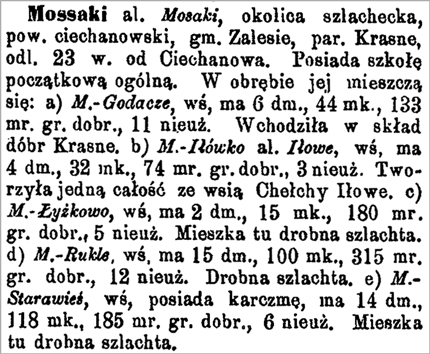
Słownik Geograficny Entry for Mossaki
Translated from the Polish, this entry states:
Mossaki also known as Mosaki, a nobleman’s neighborhood, Powiat [District] Ciechanów, Zalesie gmina [municipality], Krasne parish, 23 wiorstas [kilometers] from Ciechanów. It possesses a common elementary school. Within it, there are contained: a) Mossaki-Godacze, a village, it has 6 houses, 44 inhabitants, 133 mórgs of good arable land, 11 unused. It is part of Krasne. b) Mossaki-Iłówko also known as Iłowe, a village, it has 4 homes, 32 inhabitants, 74 mórgs of good arable land, 3 unused. It formed one whole village with the village of Chełchy Iłowe. c) Mossaki-Łyżkowo, a village, it has 2 homes, 15 inhabitants, 180 mórgs of good arable land, 5 of unused land. Lower level noblemen live here. d) Mossaki-Rukle, a village, it has 15 homes, 100 residents, 315 mórgs of good arable land, 12 unused. Lower level noblemen. e) Mossaki-Starawieś, a village, it possesses a tavern, it has 14 homes, 118 inhabitants, 186 mórgs of good arable land, 6 unused. Lower level noblemen live here.
One term that may be unfamiliar is mórg. A mórg is a measure of area – theoretically the amount of land one man could plow in a single day. The actual size of a mórg varied between the Polish Partitions: 1 mórg in the Russian Partition was 1.388 acres, in the Prussian Partition a mórg was 0.631 acres, and in the Austrian Partition a mórg was 1.422 acres. Since Mosaki (or Mossaki) was in the Russian Partition, 1 mórg in Mosaki was equal to about 1.388 acres.
This entry states that Mossaki-Godacze was part of Mossaki. The reference to Godzcze in Wojciech Niedziałkowski’s Birth and Baptismal Record apparently means Mossaki-Godacze, and therefore both the Birth and Baptismal Record and the Death Record are correct.
At the time this entry was published in 1885, Mossaki-Godacze had just 6 houses and 44 inhabitants.
This entry also verifies that Krasne is the parish for the village of Mossaki and that Mossaki is a village of lower-level nobility.
Click on the link for a PDF copy of the Słownik Geograficzny Królestwa Polskiego entry for Mosaki/Mossaki.
Copyright © 2006 by Stephen J. Danko


