
The Słownik Geograficzny Królestwa Polskiego i Innych Krajów Słowiańskich (Geographical Dictionary of the Kingdom of Poland and other Slavonic Countries) includes an entry for the village of Nienadowa in Dubiecko Parish.

Ritter, Karl. 1855. “Administrativ-Karte von Den Königreichen Galizien und Lodomerien.” Wien: Verlag und Eigenthum von Artaria & Co.; digital images, Polona (https://polona.pl/item-view/9341ec1b-5a4b-44a5-9f6b-a22c716faf46?page=36: accessed 30 November 2025)
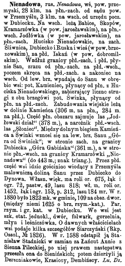
Source: Sulimierski, Filip, Bronisław Chlebowski, and Władysław Walewski, eds., Słownik Geograficzny Królestwa Polskiego i Innych Krajów Słowiańskich (Geographical Dictionary of the Kingdom of Poland and other Slavonic Countries) – Warsaw 1882, Volume III, page 202.
Click on the link for a PDF copy of the first Słownik Geograficzny entry for Nienadowa (Dubiecko Parish). Translated from the Polish, the entry reads:
Nienadowa, Nenadowa in Ruthenian; a village in Przemyśł Powiat, 28 kilometers to the north-west of the powiat court in Przemyśl, 3 kilometers east of the post office in Dubiecko. To the east are located Babice, Skopów, Kramarzówka (in Jarosław Powiat), to the north-west Hucisko Nienadowskie, to the west Śliwnica, Dubiecko and Ruska wieś (in Brzozów Powiat), to the south Iskań (in Dobromil Powiat). The San River flows along the south-west and southern border, initially from the north-west to the south-east, then it turns to the north-west and to the east. From the left bank, the following streams flow from within the village into the San River: the Kamieniec Stream, flowing from the north from Hucisko Nienadowski, absorbing numerous streams from both banks, and the Świnka Stream, flowing from the north to the south-west. The village buildings are situated in the Kamieńica valley (306 m to the north, 284 m to the south). The northern part of the area is occupied by the “Jodłowski section” forest (378 m), and the south-east corner by the “Słoniec” forest. Between the lower reaches of Kamieniec and Świnka, the “Góra od Świniek” rises on the left bank of the San; on the west side, on the border of Dubiecko, “Góra Gabińska” (361 m), and on the north-east side, on the border of Kramarzówka, “Nienadowa” (443 m, triangulation mark). The road leading from Przemyśl through the picturesque San valley through Dubiecko to Dynów goes through the southern part of the village. The larger property has 675 mórgs [1 mórg = 5755 m²] of arable land, 72 mórgs of meadows and gardens, 49 mórgs of pastures, 818 mórgs of forests; the property has 1452 mórgs of arable land, 153 mórgs of meadows and gardens, 312 mórgs of pastures, and 184 mórgs of forests.In 1880, there were 1,823 m2 residents in the gmina, 109 residents on the area of the manor (between them there were 1625 residents on the Roman Catholic shore of the San River). There are Roman Catholic and Greek Catholic parishes in Dubiecko. In the village there is a full-time one-room school, a manor house, a farm, a distillery, a mill, and a forester’s lodge. Siarczyński gives some details about the former owners of the village (Rkp. Ossolineum, No. 1826). In 1588, Stanisław Stadnicki gave up Nienadowa to Anna of Sienna Pilecka in exchange for Łańcut, after which Nienadowa passed to the Sieniński family by succession; then it was held by the Dersiniaks, the Krasickis and the Dembińskis. Lukasz Dz
Today, the historical village of Nienadowa includes two distinct villages: Nienadowa Dolna and Nienadowa Górna.
Copyright © 2025 by Stephen J. Danko


