
Ezechiel Chodowski, my 5th cousin, 3x removed, was born in Suwino. Helena Chodkowska, my 6th cousin, 2x removed, was living in Brzęczki when she was married. Finding the locations of these two villages gave me fits because neither is listed by those names in the Słownik Geograficzny Królestwa Polskiego i Innych Krajów Słowiańskich (Geographical Dictionary of the Kingdom of Poland and other Slavonic Countries). Neither are those two villages located under those names on the current map of Poland.
But, perseverance pays off. From the death record of Ezechiel Chodowski and the marriage record of Helena Chodkowska, I knew that these villages both belonged to the parish of Węgra. I looked for these villages in the vicinity of Węgra on the map of Poland at mapa.szukacz.pl and found them about 4 km to the northeast of Węgra. The names of the villages on the map? Smoleń-Suwino and Smoleń-Brzęczki. Interestingly, these two villages are not named on Google Maps at all.
The Słownik Geograficzny includes three main entries for Smoleń. The second entry includes descriptions of five smaller villages: Smolen-Brzęczki, Smoleń-Daćbogi, Smoleń-Poluby, Smoleń-Suwino, and Smoleń-Trzcianka. These five small villages appear on the Third Military Mapping Survey of Austria-Hungary on Sheet 39-53, Ostrołęcka, although they are collectively named Smoleń. Both Smoleń and its parish Węgra are highlighted on the map below by boxes surrounding the names of the villages.
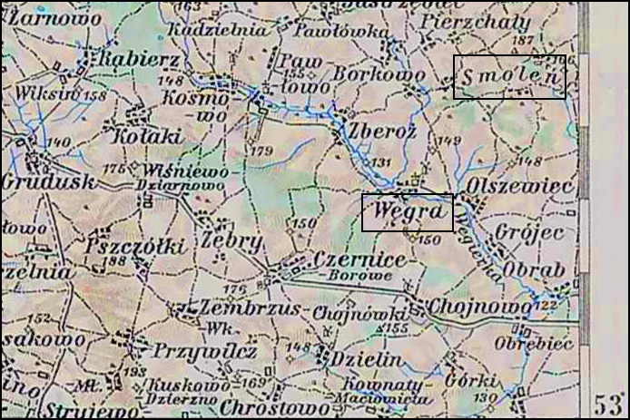
SOURCE: Third Military Mapping Survey of Austria-Hungary, 39-53, Ostrołęcka. Onlinehttp://lazarus.elte.hu/hun/digkonyv/topo/200e/39-53.jpg; downloaded 26 July 2016.
The places called Smoleń where my ancestors lived are described in subentry 2 and includes the descriptions of 5 different small villages.
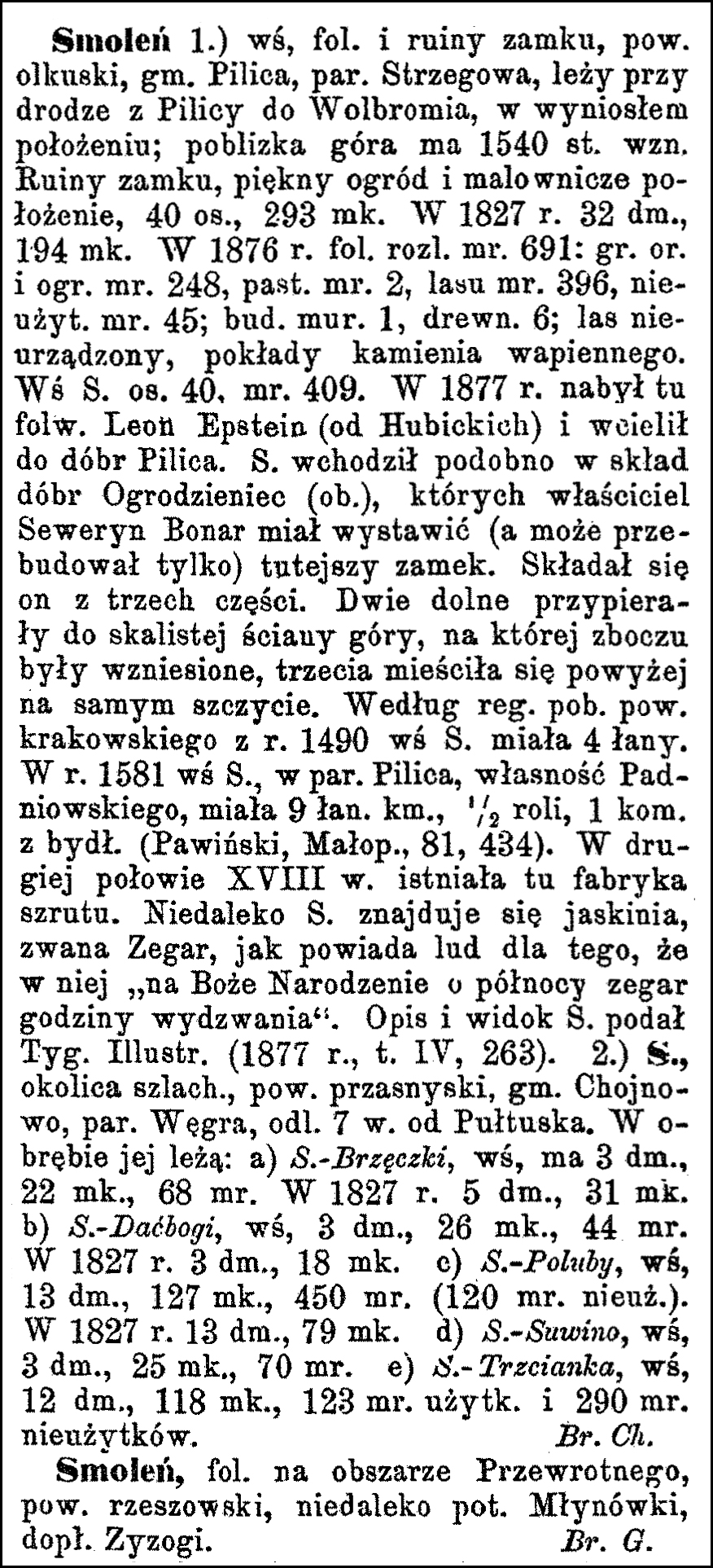
SOURCE: Sulimierski, Filip, Bronisław Chlebowski, and Władysław Walewski, eds., Słownik Geograficzny Królestwa Polskiego i Innych Krajów Słowiańskich (Geographical Dictionary of the Kingdom of Poland and other Slavonic Countries) – Warsaw 1889, Volume X, page 897, digital images, University of Warsaw ICM (http://dir.icm.edu.pl/pl/Slownik_geograficzny/Tom_X/897) : accessed 04 July 2016). Text in Polish, translated by Stephen J. Danko, 04 July 2016.
Click on the link for a PDF copy of the Słownik Geograficzny Entry for Smoleń. The record, translated from the Polish, states:
Smoleń 1) village, folwark [a large manorial farmstead], and castle ruins, Olkusz powiat [district], Pilica gmina [community], Strzegowa parish, it lies on the road from Pilica to Wolbromia, in a high position; the nearby mountain is 1540 feet high. There are castle ruins, a beautiful garden, and a scenic location, 40 settlements, 293 residents. In 1827, there were 32 homes, 194 residents. In 1876, the area of the folwark was 691 mórgs [in the Russian partition, 1 mórg = 1.388 acres], 248 mórgs of arable land and gardens, 2 mórgs of pastures, 396 mórgs of forests, 45 mórgs unused; 1 brick building, 6 wooden buildings, unimproved forest, deposits of limestone. The village of Smoleń has 40 settlements, 409 mórgs. In 1877, leon Epstein purchased the folwark here (from Hubicki) and he contributed to the goods of Pilica. Smoleń reportedly entered the goods into Ogrodzieniec (see that entry) where the owner Seweryn Bonar had erected (or perhaps had only rebuilt) the local castle. It consisted of three parts: the lower two parts stopping at a rocky mountain wall were built on a slope, and the third was located above, at the very top. According to the registers of nearby Krków powiat, in 1490, the village of Smoleń had 4 fields. In 1581, the village of Smoleń in Pilica parish, the property of the Padniowskiegos, had 9 peasant fields, ½ agricultural, 1 enclosure with animals. (Pawiński, Małop., 81, 434). In the second half of the eighteenth century, there was a gravel factory here. There is a cave called The Clock. Therefore, the people say that, therein, at Christmas midnight the clock hour tolls. A description and image are provided in Tyg. Illustr. (1877 r., t. IV, 263).
2) Smoleń, an area of nobles, Przasnysz powiat, Chojnowo gmina, Węgra parish, 7 versts [1 verst = 0.663 miles] from Pułtusk. Within this are:
a) Smolen-Brzęczki, a village with 3 homes, 22 residents, and 68 mórgs. In 1827, there were 5 homes and 31 residents;
b) Smoleń-Daćbogi, a village with 3 homes, 26 residents, and 44 mórgs.
In 1827, there were 3 homes and 18 residents;
c) Smoleń-Poluby, a village with 13 homes, 127 residents, and 450 mórgs (120 mórgs unused). In 1827, there were 13 homes and 79 residents;
d) Smoleń-Suwino, a village with 12 homes, 25 residents, and 70 mórgs.
e) Smoleń-Trzcianka, a village with 12 homes, 188 residents, and 123 mórgs cultivated and 290 mórgs uncultivated.
Br[onisław] Ch[lebowski]
Smoleń, a folwark in the Przewrotne area, Rzesów powiat, not far from the Młynówka River, a tributary of the Zyzogi.
Br[onisław] G[ustawicz]
Copyright © 2016 by Stephen J. Danko


