The Marriage Record for Antoni Wszeborowski and Małgorzata née Podeszwa Skowrońska – 1892

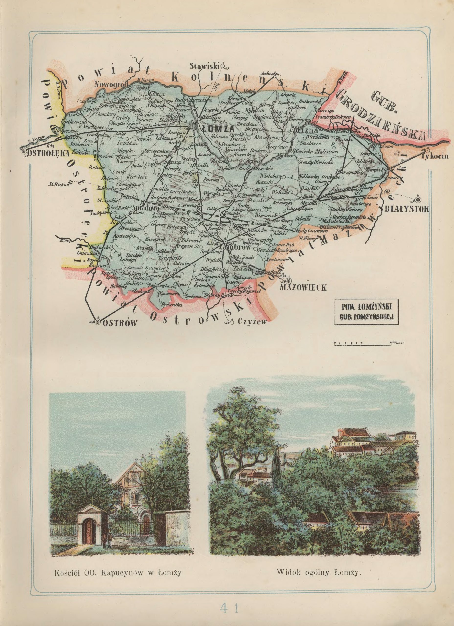
Antoni Wseborowski, the son of Katarzyna Wseborowski and widower after the death of his first wife Ewa Pydzewska, was married to Małgorzata née Podeszwa Skowrońska, daughter of Jakub Podeszwa and Anna Dymerska and widow after the death of her husband Franciszek Skowronski, on 27 January 1892 in Nowogród, Łomża Powiat, Łomża Gubernia, Congress Kingdom of Poland.

Marriage Record for Antoni Wseborowski and Małgorzata née Podeszwa Skowrońska - 1892

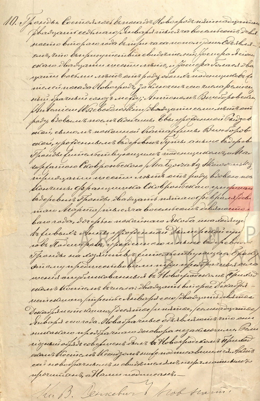
Marriage Record for Antoni Wseborowski and Małgorzata née Podeszwa Skowrońska – 1892

Roman Catholic Parish of the Nativity of the Blessed Virgin Mary (Nowogród, Łomża Powiat, Łomża Gubernia, Congress Kingdom of Poland), Civil Registrations of the Roman Catholic Parish of Nowogród for the Year 1892, folio 27 recto, entry 10, marriage record for Antoni Wseborowski and Małgorzata née Podeszwa Skowrońska, recorded 27 January 1892; State Archives in Bialystok Branch in Łomża, digital images, Szukaj w Archiwach (https://www.szukajwarchiwach.gov.pl : accessed 18 January 2021).

Click on the image above to view a higher resolution image. Click on the link for a PDF copy of the Marriage Record for Antoni Wszeborowski and Małgorzata née Podeszwa Skowrońska. Translated from the Russian, the record reads:

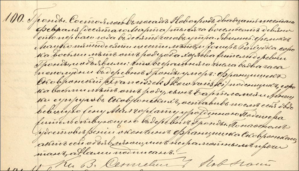
10. Grądy. This happened in the village of Novogród on the fifteenth [Julian Calendar]/ twenty-seventh [Gregorian Calendar]/ of January in the year one-thousand eight-hundred and ninety-two at three o’clock in the afternoon. We declare that in the presence of witnesses: Józef Jasionowski, twenty-six years old, and Józef Gołaś, twenty-eight years old, both day laborers and residents of the village of Nowogród, a religious marriage was contracted on this date between Antoni Wszeborowski, twenty-seven years old, widowed after the death of Eva née Pydzewska, the son of the deceased Katarzyna Wszeborowska, born in the village of Guty and now working as a day-laborer, residing in the village of Grądy, and Malgorzata Skowrońska, thirty-six years old, the widow of the deceased Franciszek Skowroński who died in the village of Grądy on the twenty-fifth of February [Gregorian Calendar]/ the ninth of March [Julian Calendar]/ in the year one-thousand eight-hundred and ninety-one, the daughter of the late Jakub and the still-living Anna née Dymerska Podeszfa, born in the village of Grądy and now residing on a farm in the village of Grądy. This marriage was preceded by three announcements of the banns in the Novogród Parish Church on: the twenty-second and twenty-ninth of December of the previous year and the tenth of January of the current year [Julian Calendar] / third, fifth, and seventeenth of January of the current year [Gregorian Calendar]. The newlyweds announce that they have not concluded any prenuptial agreement. The religious rite was performed in the Novogród Parish Church by the priest who signed below. This record was read to the newlyweds and to the witnesses who are illiterate, and signed by us. Reverend [Wincenty] Sienkiewicz, Nowogród Parish

Małgorzata née Podeszwa Skowrońska was the paternal grandmother of Helen Skowronski, the wife of my paternal uncle, Joseph Danko.

Copyright © 2021 by Stephen J. Danko

Posted in Daily Journal | Comments Off on The Marriage Record for Antoni Wszeborowski and Małgorzata née Podeszwa Skowrońska – 1892

The Birth and Baptismal Record for Maryanna Skowrońska – 1835

Maryanna Skowrońska, daughter of Bartłomiej Skowroński and Agnieszka Ciak, was born on 24 March 1835 in Trzaski, Ostrołęka Powiat, Płock Gubernia, Congress Kingdom of Poland. She was baptized at the parish church in Kleczkowo, Ostrołęka Powiat, Płock Gubernia, Congress Kingdom of Poland on 25 March 1835.

Birth and Baptismal Record for Maryanna Skowrońska - 1835

Birth and Baptismal Record for Maryanna Skowrońska – 1835

Roman Catholic Parish of Saint Lawrence (Kleczkowo, Ostrołęka Powiat, Łomża Gubernia, Congress Kingdom of Poland), Civil Registrations of the Roman Catholic Parish of Kleczkowo for the Year 1835, Akt 21, birth and baptismal record for Maryanna Skowrońska, recorded 25 Mar 1835; State Archives in Bialystok Branch in Łomża.

Click on the image above to view a higher resolution image. Click on the link for a PDF copy of the Birth and Baptismal Record for Maryanna Skowrońska. Translated from the Polish, the record reads:

No. 21. Trzaski. This happened in village of Kleczkowo on the thirteenth [Julian calendar]/ twenty-fifth [Gregorian calendar] of March in the year one-thousand eight hundred thirty-five at eleven o’clock before noon. There appeared the peasant Bartłomiej Skowroński, a farmhand at the manor, residing in Trzaski, thirty-three years of age, in the presence of Wojciech Walerzak, a farmer [on land cleared from the forest], twenty-six years old, and also Jan Truszkowski, a farmhand at the manor, twenty-three years old, both residing in Traszki, and he showed us a female child born in Trzaski on the twelfth [Julian Calendar] / twenty-fourth [Gregorian Calendar] day of this month, at the hour of eleven at night of his wife Agnieszka née Ciak, twenty-seven years old. At Holy Baptism performed on this day, the child was given the name Maryanna Skowrońska, and her godparents were the afore-mentioned Jan Truszkowski and Franciszka Walerzak. This document was read aloud to the declarant and witnesses which, since they could not write, was signed by Us.
Reverend Jan Uszyński, pastor of the parish of Kleczkowo

Maryanna Skowrońska was the paternal grandaunt of Helen Skowronski, the wife of my paternal uncle, Joseph Danko.

Copyright © 2021 by Stephen J. Danko

Posted in Daily Journal | Comments Off on The Birth and Baptismal Record for Maryanna Skowrońska – 1835

The Birth and Baptismal Record for Anna Skowrońska – 1837

Anna Skowrońska, daughter of Bartłomiej Skowroński and Agnieszka Ciak, was born on 20 June 1837 in Trzaski, Ostrołęka Powiat, Płock Gubernia, Congress Kingdom of Poland. She was baptized at the parish church in Kleczkowo, Ostrołęka Powiat, Płock Gubernia, Congress Kingdom of Poland on 21 June 1837.

Birth and Baptismal Record for Anna Skowrońska - 1837

Birth and Baptismal Record for Anna Skowrońska – 1837

Roman Catholic Parish of Saint Lawrence (Kleczkowo, Ostrołęka Powiat, Łomża Gubernia, Congress Kingdom of Poland), Civil Registrations of the Roman Catholic Parish of Kleczkowo for the Year 1837, Akt 31, birth and baptismal record for Anna Skowrońska, recorded 21 Jun 1837; State Archives in Bialystok Branch in Łomża.

Click on the image above to view a higher resolution image. Click on the link for a PDF copy of the Birth and Baptismal Record for Anna Skowrońska. Translated from the Polish, the record reads:

No. 31. Trzaski. This happened in village of Kleczkowo on the ninth [Julian calendar]/ twenty-first [Gregorian calendar] of June in the year one-thousand eight hundred thirty-seven at seven o’clock in the morning. There appeared Bartłomiej Skowroński, a servant at the manor, residing in Trzaski, thirty years of age, in the presence of the peasant Paweł‚ Michalak, fifty-nine years old, and also Kacper Cerkies, forty-six years old, both farmers residing in Traszki, and he showed us a female child born in Trzaski yesterday, at the hour of eleven before noon of his wife Agnieszka née Ciak, twenty-eight years old. At Holy Baptism performed on this day, the child was given the name Anna Skowrońska, and her godparents were the afore-mentioned Kacper Cerkies and Barbara Ślaska. This document was read aloud to the declarant and witnesses which, since they could not write, was signed by Us.
Reverend Jan Uszyński, pastor of Kleczkowo, Canon of Płock

Anna Skowrońska was the paternal grandaunt of Helen Skowronski, the wife of my paternal uncle, Joseph Danko.

Copyright © 2021 by Stephen J. Danko

Posted in Daily Journal | Comments Off on The Birth and Baptismal Record for Anna Skowrońska – 1837

The Birth and Baptismal Record for Franciszek Skowroński – 1844

Franciszek Skowroński, son of Bartłomiej Skowroński and Agnieszka Ciak, was born on 02 June 1844 in Kleczkowo, Ostrołęka Powiat, Płock Gubernia, Congress Kingdom of Poland. He was baptized at the parish church in Kleczkowo, Ostrołęka Powiat, Płock Gubernia, Congress Kingdom of Poland on 06 June 1844.

Birth and Baptismal Record for Franciszek Skowroński - 1844

Birth and Baptismal Record for Franciszek Skowroński – 1844

Roman Catholic Parish of Saint Lawrence (Kleczkowo, Ostrołeka Powiat, Łomża Gubernia, Congress Kingdom of Poland), Civil Registrations of the Roman Catholic Parish of Kleczkowo for the Year 1844, Akt 36, birth and baptismal record for Franciszek Skowroński, recorded 06 Jun 1844; State Archives in Bialystok Branch in Łomża.

Click on the image above to view a higher resolution image. Click on the link for a PDF copy of the Birth and Baptismal Record for Franciszek Skowroński. Translated from the Polish, the record reads:

No. 36 Kleczkowo. This happened in village of Kleczkowo on the / twenty-fifth of May [Julian calendar]/ sixth of June [Gregorian calendar] in the year one-thousand eight hundred forty-four at ten o’clock before noon. There appeared Bartłomiej Skowroński, a farmer [on land cleared from the forest] residing here in Klezkowo, thirty-eight years of age, in the presence of Kacper Kupidłoski, thirty-two years old, and also Jan Tkacz, twenty-three years old, both farmers [on land cleared from the forest] residing here in Kleczkowo, and he showed us a male child born here in Kleczkowo on the / twenty-first of May [Julian Calendar] / second of June [Gregorian Calendar] of this year, at two in the afternnon of his wife Agnieszka née Ciak, thirty-nine years old. At Holy Baptism performed on this day, the child was given the name Franciszek Skowroński, and his godparents were Mikołaj Podgórski and Ewa Kupidłoska. This document was read aloud to the declarant and witnesses which, when they declared they could not write, was signed by Us.
Reverend Jan Uszyński, Canon of Płock, pastor of Kleczkowo.

Franciszek Skowroński was the paternal grandfather of Helen Skowronski, the wife of my paternal uncle, Joseph Danko.

Copyright © 2021 by Stephen J. Danko

Posted in Daily Journal | Comments Off on The Birth and Baptismal Record for Franciszek Skowroński – 1844

The Death and Burial Record for Franciszek Skowroński – 1891

Franciszek Skowroński, son of Bartłomiej Skowroński and Agnieszka Ciak, died on 09 March 1891 in Grądy, Łomża Powiat, Łomża Gubernia, Congress Kingdom of Poland. He was buried at the parish cemetery in Nowogród, Łomża Powiat, Łomża Gubernia, Congress Kingdom of Poland on 10 March 1891.

Death and Burial Record for Franciszek Skowroński - 1891

Death and Burial Record for Franciszek Skowroński – 1891

SOURCE: Roman Catholic Parish of the Nativity of the Blessed Virgin Mary (Nowogród, Łomża Powiat, Łomża Gubernia, Congress Kingdom of Poland), Civil Registrations of the Roman Catholic Parish of Nowogród for the Year 1891, folio 202 verso, entry 100, death and burial record for Franciszek Skowroński, recorded 10 March 1891; State Archives in Bialystok Branch in Łomża, digital images, Szukaj w Archiwach (https://szukajwarchiwach.gov.pl : accessed 17 January 2021).

Click on the image above to view a higher resolution image. Click on the link for a PDF copy of the Death and Burial Record for Franciszek Skowroński. Translated from the Russian, the record reads:

100. Grądy. This happened in village of Nowogród on the twenty-sixth of February [Julian calendar]/ tenth of March [Gregorian calendar]/ in the year one-thousand eight hundred ninety-one at ten o’clock in the morning. There appeared: Feliks Macko, fifty-six years old, and Józef Rachudna forty-eight years old, both farmers residing in the village of Grądy, and they stated: that yesterday at two o’clock in the morning, in the village of Grądy, Franciszek Skowroński, a day-laborer, died, forty-eight years old, the son of the married couple Bartłomiej and Agnieszka Skowroński, leaving behind his wife Małgorzata née Podeszfa residing in the village of Grądy. After eyewitness testamony on the death of Franciszek Skowroński, this document was read aloud to the illiterate and was signed by us.
Reverend [Wincenty] Sienkiewicz, Nowogród Parish

Franciszek Skowroński was the paternal grandfather of Helen Skowronski, the wife of my paternal uncle, Joseph Danko.

Copyright © 2021 by Stephen J. Danko

Posted in Daily Journal | Comments Off on The Death and Burial Record for Franciszek Skowroński – 1891

Administrative Structure of the Płock Powiat

The following parishes were part of the Płock Powiat at the beginning of the 20th Century: Biała (Stara Biała), Bielsk, Blichowo, Bodzanów, Bonisław, Brwilno, Bulkowo, Chylino (Chylin), Ciachcin, Daniszewo, Drobin, Góra (Nowa Góra), Imielnica, Kobylniki, Łęg (Łęg Kościelny), Łętowo, Łubki (Stare Łubki), Miszewko Gawarckie (Miszewko), Miszewko Strzałkowskie, Miszewo Murowane, Orszymowo, Pilichowo, Płock, Proboszczewice, Radzanowo, Rębowo, Rogotwórsk, Sikórz, Słupia, Słupno, Staroźreby, Swięcieniec, Trzepowo, Woźniki, Wyszogród, Zagroba, and Zakrzewo.

Płock Powiat in the Płock Gubernia - 1907
Płock Powiat in the Płock Gubernia – 1907
Józef Michał Bazewicz, Atlas geograficzny ilustrowany Królestwa Polskiego (Litografia B. A. Bukaty, Warsaw, 1907); digital images, Mapywig (http://igrek.amzp.pl/details.php?id=11767107 : accessed 25 March 2019).

The administrative structure of the parishes of Biała (Stara Biała), Bielsk, Blichowo, Brwilno, Chylino (Stary Chylin), Ciachcin, Daniszewo, Drobin, Góra (Nowa Góra), Imielnica, Kobylniki, Łęg (Łęg Kościelny), Łętowo, Łubki (Stare Łubki), Miszewko Gawarckie (Miszewko), Miszewko Strzałkowskie, Miszewo Murowane, Orszymowo, Pilichowo, Płock, Radzanowo, Rębowo, Rogotwórsk, Sikórz, Słupno, Staroźreby, Swięcieniec, Woźniki, Wyszogród, Zagroba, and Zakrzewo can be described as follows:

  • 01 Jul 1569-03 Oct 1795: Village, Dobrzyń Ziemia, Masovian Voivodeship, Crown of the Kingdom of Poland, Polish-Lithuanian Commonwealth
  • 04 Oct 1795-08 Jul 1807: Village, Kreis Płock, Kammerdepartement Płock, Province of New East Prussia Prussia, Kingdom of Prussia
  • 09 Jul 1807-08 Jun 1815: Village, Wyszogród Powiat, Płock Department, Duchy of Warsaw
  • 09 Jun 1815-15 Jan 1816: Village, Wyszogród Powiat, Płock Department, Congress Kingdom of Poland
  • 16 Jan 1816-06 Mar 1837: Village, Płock Obwód, Płock Voivodeship, Congress Kingdom of Poland
  • 07 Mar 1837-10 Nov 1842: Village, Płock Obwód, Płock Gubernia, Congress Kingdom of Poland
  • 11 Nov 1842-07 Sep 1915: Village, Płock Powiat, Płock Gubernia, Congress Kingdom of Poland
  • 08 Sep 1915-10 Nov 1918: Village, Płock Powiat, General Government of Warsaw, German Empire
  • 11 Nov 1918-07 Oct 1939: Village, Płock Powiat, Warsaw Voivodeship, Second Polish Republic
  • 08 Oct 1939-27 Jun 1945: Village, Kreis Schröttersburg, Regierungsbezirk Marienwerder, Reichsgau Danzig-West Prussia, German Reich
  • 28 Jun 1945-21 Jul 1952: Village, Płock Powiat, Warsaw Voivodeship, Republic of Poland
  • 22 Jul 1952-31 May 1975: Village, Płock Powiat, Warsaw Voivodeship, Polish People’s Republic
  • 01 Jun 1975-30 Dec 1989: Village, Płock Voivodeship, Polish People’s Republic
  • 31 Dec 1989-30 Dec 1998: Village, Płock Voivodeship, Third Polish Republic
  • 31 Dec 1998-Present: Village, Płock Powiat, Masovian Voivodeship, Third Polish Republic

The administrative structure of the parishes of Bonisław and Słupia can be described as follows:

  • 01 Jul 1569-03 Oct 1795: Village, Dobrzyń Ziemia, Masovian Voivodeship, Crown of the Kingdom of Poland, Polish-Lithuanian Commonwealth
  • 04 Oct 1795-08 Jul 1807: Village, Kreis Płock, Kammerdepartement Płock, Province of New East Prussia Prussia, Kingdom of Prussia
  • 09 Jul 1807-08 Jun 1815: Village, Wyszogród Powiat, Płock Department, Duchy of Warsaw
  • 09 Jun 1815-15 Jan 1816: Village, Wyszogród Powiat, Płock Department, Congress Kingdom of Poland
  • 16 Jan 1816-06 Mar 1837: Village, Płock Obwód, Płock Voivodeship, Congress Kingdom of Poland
  • 07 Mar 1837-10 Nov 1842: Village, Płock Obwód, Płock Gubernia, Congress Kingdom of Poland
  • 11 Nov 1842-07 Sep 1915: Village, Płock Powiat, Płock Gubernia, Congress Kingdom of Poland
  • 08 Sep 1915-10 Nov 1918: Village, Płock Powiat, General Government of Warsaw, German Empire
  • 11 Nov 1918-07 Oct 1939: Village, Płock Powiat, Warsaw Voivodeship, Second Polish Republic
  • 08 Oct 1939-27 Jun 1945: Village, Kreis Schröttersburg, Regierungsbezirk Marienwerder, Reichsgau Danzig-West Prussia, German Reich
  • 28 Jun 1945-21 Jul 1952: Village, Płock Powiat, Warsaw Voivodeship, Republic of Poland
  • 22 Jul 1952-31 May 1975: Village, Płock Powiat, Warsaw Voivodeship, Polish People’s Republic
  • 01 Jun 1975-30 Dec 1989: Village, Płock Voivodeship, Polish People’s Republic
  • 31 Dec 1989-30 Dec 1998: Village, Płock Voivodeship, Third Polish Republic
  • 31 Dec 1998-Present: Village, Sierpc Powiat, Masovian Voivodeship, Third Polish Republic

The administrative structure of the parish of Proboszczewice can be described as follows:

  • 01 Jul 1569-03 Oct 1795: Village, Płock Ziemia, Masovian Voivodeship, Crown of the Kingdom of Poland, Polish-Lithuanian Commonwealth
  • 04 Oct 1795-08 Jul 1807: Village, Kreis Płock, Kammerdepartement Płock, Province of New East Prussia Prussia, Kingdom of Prussia
  • 09 Jul 1807-08 Jun 1815: Village, Wyszogród Powiat, Płock Department, Duchy of Warsaw
  • 09 Jun 1815-15 Jan 1816: Village, Wyszogród Powiat, Płock Department, Congress Kingdom of Poland
  • 16 Jan 1816-06 Mar 1837: Village, Płock Obwód, Płock Voivodeship, Congress Kingdom of Poland
  • 07 Mar 1837-10 Nov 1842: Village, Płock Obwód, Płock Gubernia, Congress Kingdom of Poland
  • 11 Nov 1842-07 Sep 1915: Village, Płock Powiat, Płock Gubernia, Congress Kingdom of Poland
  • 08 Sep 1915-10 Nov 1918: Village, Płock Powiat, General Government of Warsaw, German Empire
  • 11 Nov 1918-07 Oct 1939: Village, Płock Powiat, Warsaw Voivodeship, Second Polish Republic
  • 08 Oct 1939-27 Jun 1945: Village, Kreis Schröttersburg, Regierungsbezirk Marienwerder, Reichsgau Danzig-West Prussia, German Reich
  • 28 Jun 1945-21 Jul 1952: Village, Płock Powiat, Warsaw Voivodeship, Republic of Poland
  • 22 Jul 1952-31 May 1975: Village, Płock Powiat, Warsaw Voivodeship, Polish People’s Republic
  • 01 Jun 1975-30 Dec 1989: Village, Ciechanów Voivodeship, Polish People’s Republic
  • 31 Dec 1989-30 Dec 1998: Village, Ciechanów Voivodeship, Third Polish Republic
  • 31 Dec 1998-Present: Village, Płonsk Powiat, Masovian Voivodeship, Third Polish Republic

Copyright © 2019-2022 by Stephen J. Danko

Posted in Daily Journal | Tagged | Comments Off on Administrative Structure of the Płock Powiat

Administrative Structure of the Łomża Powiat

The following parishes were part of the Łomża Powiat at the beginning of the 20th Century: Drozdowo, Kolaki Kościelne, Łomża, Stary Lubotyń, Miastkowo, Nowogród, Piątnica Poduchowna, Rutki-Kossaki, Śniadowo, Szczepankowo, Wizna, Zambrów, and Zawady.

Łomża Powiat in the Łomża Gubernia - 1907
Łomża Powiat in the Łomża Gubernia – 1907
Józef Michał Bazewicz, Atlas geograficzny ilustrowany Królestwa Polskiego (Litografia B. A. Bukaty, Warsaw, 1907); digital images, Mapywig (http://igrek.amzp.pl/details.php?id=11767092 : accessed 14 Nov 2021).

The administrative structure of the parishes of Łomża, Miastkowo, Nowogród, Śniadowo, Szczepankowo can be described as follows:

  • 01 Jul 1569-03 Oct 1795: Village, Łomża Ziemia, Masovia Voivodeship, Province of Greater Poland, Polish-Lithuanian Commonwealth
  • 04 Oct 1795-08 Jul 1807: Village, Kammerdepartement Białystok, Province of New East Prussia, Kingdom of Prussia
  • 09 Jul 1807-08 Jun 1815: Village, Łomża Powiat, Łomża Department, Duchy of Warsaw
  • 09 Jun 1815-15 Jan 1816: Village, Łomża Powiat, Łomża Department, Congress Kingdom of Poland
  • 16 Jan 1816-09 Nov 1842: Village, Łomża Obwód, Augustów Voivodeship, Congress Kingdom of Poland
  • 10 Nov 1842-30 Dec 1866: Village, Łomża Obwód, Augustów Gubernia, Congress Kingdom of Poland
  • 31 Dec 1866-07 Sep 1915: Village, Łomża Powiat, Łomża Gubernia, Congress Kingdom of Poland
  • 08 Sep 1915-10 Nov 1918: Village, Łomża Powiat, General Government of Warsaw, German Empire
  • 11 Nov 1918-31 Mar 1938: Village, Łomża Powiat, Białystok Voivodeship, Second Polish Republic
  • 01 Apr 1938-03 Dec 1939: Village, Łomża Powiat, Warsaw Voivodeship, Second Polish Republic
  • 04 Dec 1939-21 Jul 1941: Village, Bialystok Oblast, Byelorussian SSR, USSR
  • 22 Jul 1941-19 Sep 1944: Village, Landkreis Lomscha, Bezirk Bialystok, German Reich
  • 20 Sep 1944-15 Aug 1945: Village, Grodno Oblast, Byelorussian SSR, USSR
  • 16 Aug 1945-18 Feb 1947: Village, Łomża Powiat, Białystok Voivodeship, Provisional Government of National Unity
  • 19 Feb 1947-21 Jul 1952: Village, Łomża Powiat, Białystok Voivodeship, Republic of Poland
  • 22 Jul 1952-31 May 1975: Village, Łomża Powiat, Białystok Voivodeship, Polish People’s Republic
  • 01 Jun 1975-30 Dec 1989: Village, Łomża Voivodeship, Polish People’s Republic
  • 31 Dec 1989-30 Dec 1998: Village, Łomża Voivodeship, Third Polish Republic
  • 31 Dec 1998-Present: Village, Łomża Powiat, Podlaskie Voivodeship, Third Polish Republic

The administrative structure of the parishes of Drozdowo and Piątnica Poduchowna can be described as follows:

  • 01 Jul 1569-03 Oct 1795: Village, Wizna Ziemia, Masovia Voivodeship, Province of Greater Poland, Polish-Lithuanian Commonwealth
  • 04 Oct 1795-08 Jul 1807: Village, Kammerdepartement Białystok, Province of New East Prussia, Kingdom of Prussia
  • 09 Jul 1807-08 Jun 1815: Village, Łomża Powiat, Łomża Department, Duchy of Warsaw
  • 09 Jun 1815-15 Jan 1816: Village, Łomża Powiat, Łomża Department, Congress Kingdom of Poland
  • 16 Jan 1816-09 Nov 1842: Village, Łomża Obwód, Augustów Voivodeship, Congress Kingdom of Poland
  • 10 Nov 1842-30 Dec 1866: Village, Łomża Obwód, Augustów Gubernia, Congress Kingdom of Poland
  • 31 Dec 1866-07 Sep 1915: Village, Łomża Powiat, Łomża Gubernia, Congress Kingdom of Poland
  • 08 Sep 1915-10 Nov 1918: Village, Łomża Powiat, General Government of Warsaw, German Empire
  • 11 Nov 1918-31 Mar 1938: Village, Łomża Powiat, Białystok Voivodeship, Second Polish Republic
  • 01 Apr 1938-03 Dec 1939: Village, Łomża Powiat, Warsaw Voivodeship, Second Polish Republic
  • 04 Dec 1939-21 Jul 1941: Village, Bialystok Oblast, Byelorussian SSR, USSR
  • 22 Jul 1941-19 Sep 1944: Village, Landkreis Lomscha, Bezirk Bialystok, German Reich
  • 20 Sep 1944-15 Aug 1945: Village, Grodno Oblast, Byelorussian SSR, USSR
  • 16 Aug 1945-18 Feb 1947: Village, Łomża Powiat, Białystok Voivodeship, Provisional Government of National Unity
  • 19 Feb 1947-21 Jul 1952: Village, Łomża Powiat, Białystok Voivodeship, Republic of Poland
  • 22 Jul 1952-31 May 1975: Village, Łomża Powiat, Białystok Voivodeship, Polish People’s Republic
  • 01 Jun 1975-30 Dec 1989: Village, Łomża Voivodeship, Polish People’s Republic
  • 31 Dec 1989-30 Dec 1998: Village, Łomża Voivodeship, Third Polish Republic
  • 31 Dec 1998-Present: Village, Łomża Powiat, Podlaskie Voivodeship, Third Polish Republic

The administrative structure of the parish of Wizna can be described as follows:

  • 01 Jul 1569-03 Oct 1795: Village, Wizna Ziemia, Masovia Voivodeship, Province of Greater Poland, Polish-Lithuanian Commonwealth
  • 04 Oct 1795-08 Jul 1807: Village, Kammerdepartement Białystok, Province of New East Prussia, Kingdom of Prussia
  • 09 Jul 1807-08 Jun 1815: Village, Biebrza Powiat, Łomża Department, Duchy of Warsaw
  • 09 Jun 1815-15 Jan 1816: Village, Łomża Powiat, Łomża Department, Congress Kingdom of Poland
  • 16 Jan 1816-09 Nov 1842: Village, Augustów Obwód, Augustów Voivodeship, Congress Kingdom of Poland
  • 10 Nov 1842-30 Dec 1866: Village, Augustów Obwód, Augustów Gubernia, Congress Kingdom of Poland
  • 31 Dec 1866-07 Sep 1915: Village, Łomża Powiat, Łomża Gubernia, Congress Kingdom of Poland
  • 08 Sep 1915-10 Nov 1918: Village, Łomża Powiat, General Government of Warsaw, German Empire
  • 11 Nov 1918-31 Mar 1938: Village, Lomża Powiat, Białystok Voivodeship, Second Polish Republic
  • 01 Apr 1938-03 Dec 1939: Village, Łomża Powiat, Warsaw Voivodeship, Second Polish Republic
  • 04 Dec 1939-21 Jul 1941: Village, Bialystok Oblast, Byelorussian SSR, USSR
  • 22 Jul 1941-19 Sep 1944: Village, Landkreis Lomscha, Bezirk Bialystok, German Reich
  • 20 Sep 1944-15 Aug 1945: Village, Grodno Oblast, Byelorussian SSR, USSR
  • 16 Aug 1945-18 Feb 1947: Village, Łomża Powiat, Białystok Voivodeship, Provisional Government of National Unity
  • 19 Feb 1947-21 Jul 1952: Village, Łomża Powiat, Białystok Voivodeship, Republic of Poland
  • 22 Jul 1952-31 May 1975: Village, Łomża Powiat, Białystok Voivodeship, Polish People’s Republic
  • 01 Jun 1975-30 Dec 1989: Village, Łomża Voivodeship, Polish People’s Republic
  • 31 Dec 1989-30 Dec 1998: Village, Łomża Voivodeship, Third Polish Republic
  • 31 Dec 1998-Present: Village, Łomża Powiat, Podlaskie Voivodeship, Third Polish Republic

The administrative structure of the parish of Stary Lubotyń can be described as follows:

  • 01 Jul 1569-03 Oct 1795: Village, Łomża Ziemia, Masovia Voivodeship, Province of Greater Poland, Polish-Lithuanian Commonwealth
  • 04 Oct 1795-08 Jul 1807: Village, Kammerdepartement Białystok, Province of New East Prussia, Kingdom of Prussia
  • 09 Jul 1807-08 Jun 1815: Village, Łomża Powiat, Łomża Department, Duchy of Warsaw
  • 09 Jun 1815-15 Jan 1816: Village, Łomża Powiat, Łomża Department, Congress Kingdom of Poland
  • 16 Jan 1816-09 Nov 1842: Village, Łomża Obwód, Augustów Voivodeship, Congress Kingdom of Poland
  • 10 Nov 1842-30 Dec 1866: Village, Łomża Obwód, Augustów Gubernia, Congress Kingdom of Poland
  • 31 Dec 1866-07 Sep 1915: Village, Łomża Powiat, Łomża Gubernia, Congress Kingdom of Poland
  • 08 Sep 1915-10 Nov 1918: Village, Łomża Powiat, General Government of Warsaw, German Empire
  • 11 Nov 1918-31 Mar 1938: Village, Łomża Powiat, Białystok Voivodeship, Second Polish Republic
  • 01 Apr 1938-03 Dec 1939: Village, Łomża Powiat, Warsaw Voivodeship, Second Polish Republic
  • 04 Dec 1939-21 Jul 1941: Village, Bialystok Oblast, Byelorussian SSR, USSR
  • 22 Jul 1941-19 Sep 1944: Village, Landkreis Lomscha, Bezirk Bialystok, German Reich
  • 20 Sep 1944-15 Aug 1945: Village, Grodno Oblast, Byelorussian SSR, USSR
  • 16 Aug 1945-18 Feb 1947: Village, Łomża Powiat, Białystok Voivodeship, Provisional Government of National Unity
  • 19 Feb 1947-21 Jul 1952: Village, Łomża Powiat, Białystok Voivodeship, Republic of Poland
  • 22 Jul 1952-31 May 1975: Village, Łomża Powiat, Białystok Voivodeship, Polish People’s Republic
  • 01 Jun 1975-30 Dec 1989: Village, Ostrołęka Voivodeship, Polish People’s Republic
  • 31 Dec 1989-30 Dec 1998: Village, Ostrołęka Voivodeship, Third Polish Republic
  • 31 Dec 1998-Present: Village, Ostrów Powiat, Masovian Voivodeship, Third Polish Republic

The administrative structure of the parish of Zambrów can be described as follows:

  • 01 Jul 1569-03 Oct 1795: Village, Łomża Ziemia, Masovia Voivodeship, Province of Greater Poland, Polish-Lithuanian Commonwealth
  • 04 Oct 1795-08 Jul 1807: Village, Kammerdepartement Białystok, Province of New East Prussia, Kingdom of Prussia
  • 09 Jul 1807-08 Jun 1815: Village, Łomża Powiat, Łomża Department, Duchy of Warsaw
  • 09 Jun 1815-15 Jan 1816: Village, Łomża Powiat, Łomża Department, Congress Kingdom of Poland
  • 16 Jan 1816-09 Nov 1842: Village, Łomża Obwód, Augustów Voivodeship, Congress Kingdom of Poland
  • 10 Nov 1842-30 Dec 1866: Village, Łomża Obwód, Augustów Gubernia, Congress Kingdom of Poland
  • 31 Dec 1866-07 Sep 1915: Village, Łomża Powiat, Łomża Gubernia, Congress Kingdom of Poland
  • 08 Sep 1915-10 Nov 1918: Village, Łomża Powiat, General Government of Warsaw, German Empire
  • 11 Nov 1918-31 Mar 1938: Village, Łomża Powiat, Białystok Voivodeship, Second Polish Republic
  • 01 Apr 1938-03 Dec 1939: Village, Łomża Powiat, Warsaw Voivodeship, Second Polish Republic
  • 04 Dec 1939-21 Jul 1941: Village, Bialystok Oblast, Byelorussian SSR, USSR
  • 22 Jul 1941-19 Sep 1944: Village, Landkreis Lomscha, Bezirk Bialystok, German Reich
  • 20 Sep 1944-15 Aug 1945: Village, Grodno Oblast, Byelorussian SSR, USSR
  • 16 Aug 1945-18 Feb 1947: Village, Łomża Powiat, Białystok Voivodeship, Provisional Government of National Unity
  • 19 Feb 1947-21 Jul 1952: Village, Łomża Powiat, Białystok Voivodeship, Republic of Poland
  • 22 Jul 1952-12 Nov 1954: Village, Łomża Powiat, Białystok Voivodeship, Polish People’s Republic
  • 13 Nov 1954-31 May 1975: Village, Zambrów Powiat, Białystok Voivodeship, Polish People’s Republic
  • 01 Jun 1975-30 Dec 1989: Village, Ostrołęka Voivodeship, Polish People’s Republic
  • 31 Dec 1989-30 Dec 1998: Village, Ostrołęka Voivodeship, Third Polish Republic
  • 31 Dec 1998-Present: Village, Zambrów Powiat, Podlasie Voivodeship, Third Polish Republic

The administrative structure of the parish of Kołaki Kościelne can be described as follows:

  • 01 Jul 1569-03 Oct 1795: Village, Łomża Ziemia, Masovia Voivodeship, Province of Greater Poland, Polish-Lithuanian Commonwealth
  • 04 Oct 1795-08 Jul 1807: Village, Kammerdepartement Białystok, Province of New East Prussia, Kingdom of Prussia
  • 09 Jul 1807-08 Jun 1815: Village, Łomża Powiat, Łomża Department, Duchy of Warsaw
  • 09 Jun 1815-15 Jan 1816: Village, Łomża Powiat, Łomża Department, Congress Kingdom of Poland
  • 16 Jan 1816-06 Mar 1837: Village, Augustów Obwód, Augustów Voivodeship, Congress Kingdom of Poland
  • 07 Mar 1837-30 Dec 1866: Village, Augustów Obwód, Augustów Gubernia, Congress Kingdom of Poland
  • 31 Dec 1866-07 Sep 1915: Village, Łomża Powiat, Łomża Gubernia, Congress Kingdom of Poland
  • 08 Sep 1915-10 Nov 1918: Village, Łomża Powiat, General Government of Warsaw, German Empire
  • 11 Nov 1918-31 Mar 1938: Village, Łomża Powiat, Białystok Voivodeship, Second Polish Republic
  • 01 Apr 1938-03 Dec 1939: Village, Łomża Powiat, Warsaw Voivodeship, Second Polish Republic
  • 04 Dec 1939-21 Jul 1941: Village, Bialystok Oblast, Byelorussian SSR, USSR
  • 22 Jul 1941-19 Sep 1944: Village, Landkreis Lomscha, Bezirk Bialystok, German Reich
  • 20 Sep 1944-15 Aug 1945: Village, Grodno Oblast, Byelorussian SSR, USSR
  • 16 Aug 1945-18 Feb 1947: Village, Łomża Powiat, Białystok Voivodeship, Provisional Government of National Unity
  • 19 Feb 1947-21 Jul 1952: Village, Łomża Powiat, Białystok Voivodeship, Republic of Poland
  • 22 Jul 1952-12 Nov 1954: Village, Łomża Powiat, Białystok Voivodeship, Polish People’s Republic
  • 13 Nov 1954-31 May 1975: Village, Zambrów Powiat, Białystok Voivodeship, Polish People’s Republic
  • 01 Jun 1975-30 Dec 1989: Village, Łomża Voivodeship, Polish People’s Republic
  • 31 Dec 1989-30 Dec 1998: Village, Łomża Voivodeship, Third Polish Republic
  • 31 Dec 1998-Present: Village, Zambrów Powiat, Podlasie Voivodeship, Third Polish Republic

The administrative structure of the parish of Rutki-Kossaki can be described as follows:

  • 01 Jul 1569-03 Oct 1795: Village, Łomża Ziemia, Masovia Voivodeship, Province of Greater Poland, Polish-Lithuanian Commonwealth
  • 04 Oct 1795-08 Jul 1807: Village, Kammerdepartement Białystok, Province of New East Prussia, Kingdom of Prussia
  • 09 Jul 1807-08 Jun 1815: Village, Łomża Powiat, Łomża Department, Duchy of Warsaw
  • 09 Jun 1815-15 Jan 1816: Village, Łomża Powiat, Łomża Department, Congress Kingdom of Poland
  • 16 Jan 1816-06 Mar 1837: Village, Łomża Obwód, Augustów Voivodeship, Congress Kingdom of Poland
  • 07 Mar 1837-30 Dec 1866: Village, Łomża Obwód, Augustów Gubernia, Congress Kingdom of Poland
  • 31 Dec 1866-07 Sep 1915: Village, Łomża Powiat, Łomża Gubernia, Congress Kingdom of Poland
  • 08 Sep 1915-10 Nov 1918: Village, Łomża Powiat, General Government of Warsaw, German Empire
  • 11 Nov 1918-31 Mar 1938: Village, Łomża Powiat, Białystok Voivodeship, Second Polish Republic
  • 01 Apr 1938-03 Dec 1939: Village, Łomża Powiat, Warsaw Voivodeship, Second Polish Republic
  • 04 Dec 1939-21 Jul 1941: Village, Bialystok Oblast, Byelorussian SSR, USSR
  • 22 Jul 1941-19 Sep 1944: Village, Landkreis Lomscha, Bezirk Bialystok, German Reich
  • 20 Sep 1944-15 Aug 1945: Village, Grodno Oblast, Byelorussian SSR, USSR
  • 16 Aug 1945-18 Feb 1947: Village, Łomża Powiat, Białystok Voivodeship, Provisional Government of National Unity
  • 19 Feb 1947-21 Jul 1952: Village, Łomża Powiat, Białystok Voivodeship, Republic of Poland
  • 22 Jul 1952-12 Nov 1954: Village, Łomża Powiat, Białystok Voivodeship, Polish People’s Republic
  • 13 Nov 1954-31 May 1975: Village, Zambrów Powiat, Białystok Voivodeship, Polish People’s Republic
  • 01 Jun 1975-30 Dec 1989: Village, Łomża Voivodeship, Polish People’s Republic
  • 31 Dec 1989-30 Dec 1998: Village, Łomża Voivodeship, Third Polish Republic
  • 31 Dec 1998-Present: Village, Zambrów Powiat, Podlasie Voivodeship, Third Polish Republic

The administrative structure of the parish of Zawady can be described as follows:

  • 01 Jul 1569-03 Oct 1795: Village, Łomża Ziemia, Masovia Voivodeship, Province of Greater Poland, Polish-Lithuanian Commonwealth
  • 04 Oct 1795-08 Jul 1807: Village, Kammerdepartement Białystok, Province of New East Prussia, Kingdom of Prussia
  • 09 Jul 1807-08 Jun 1815: Village, Łomża Powiat, Łomża Department, Duchy of Warsaw
  • 09 Jun 1815-15 Jan 1816: Village, Łomża Powiat, Łomża Department, Congress Kingdom of Poland
  • 16 Jan 1816-06 Mar 1837: Village, Łomża Obwód, Augustów Voivodeship, Congress Kingdom of Poland
  • 07 Mar 1837-30 Dec 1866: Village, Łomża Obwód, Augustów Gubernia, Congress Kingdom of Poland
  • 31 Dec 1866-07 Sep 1915: Village, Łomża Powiat, Łomża Gubernia, Congress Kingdom of Poland
  • 08 Sep 1915-10 Nov 1918: Village, Łomża Powiat, General Government of Warsaw, German Empire
  • 11 Nov 1918-31 Mar 1938: Village, Łomża Powiat, Białystok Voivodeship, Second Polish Republic
  • 01 Apr 1938-03 Dec 1939: Village, Łomża Powiat, Warsaw Voivodeship, Second Polish Republic
  • 04 Dec 1939-21 Jul 1941: Village, Bialystok Oblast, Byelorussian SSR, USSR
  • 22 Jul 1941-19 Sep 1944: Village, Landkreis Lomscha, Bezirk Bialystok, German Reich
  • 20 Sep 1944-15 Aug 1945: Village, Grodno Oblast, Byelorussian SSR, USSR
  • 16 Aug 1945-18 Feb 1947: Village, Łomża Powiat, Białystok Voivodeship, Provisional Government of National Unity
  • 19 Feb 1947-21 Jul 1952: Village, Łomża Powiat, Białystok Voivodeship, Republic of Poland
  • 22 Jul 1952-12 Nov 1954: Village, Łomża Powiat, Białystok Voivodeship, Polish People’s Republic
  • 13 Nov 1954-31 May 1975: Village, Zambrów Powiat, Białystok Voivodeship, Polish People’s Republic
  • 01 Jun 1975-30 Dec 1989: Village, Łomża Voivodeship, Polish People’s Republic
  • 31 Dec 1989-30 Dec 1998: Village, Łomża Voivodeship, Third Polish Republic
  • 31 Dec 1998-Present: Village, Białystok Powiat, Podlasie Voivodeship, Third Polish Republic

Copyright © 2020-2021 by Stephen J. Danko

Posted in Daily Journal | Tagged | Comments Off on Administrative Structure of the Łomża Powiat

Miho no Matsubara (三保の松原 Miho Pine Grove)

Miho no Matsubara is a 7 km long seashore lined with pine trees in the Shizuoka Prefecture of Shizuoka on the island of Honshu in Japan. Miho no Matsubara is the site of the Legend of Hagoromo (The Feathered Robe) which tells of a celestial being who left her feathered robe on a pine tree so she could bathe in the water there. A fisherman named Hakuryo took the feathered robe and refused to return it until she danced for him. A statue of Hakuryo watching the dance is at the entrance to the park.

Legend of the Pine Tree
SOURCE: Legend of the Pine Tree (Shizuoka, Shizuoka Prefecture, Honshu, Japan); photographed by Stephen J. Danko on 26 April 2019.
Legend of the Pine T
Legend of the Pine Tree – Detail
SOURCE: Legend of the Pine Tree – Detail (Shizuoka, Shizuoka Prefecture, Honshu, Japan); photographed by Stephen J. Danko on 26 April 2019.
Hakuryo Holding the Robe
SOURCE: Hakuryo Holding the Robe (Shizuoka, Shizuoka Prefecture, Honshu, Japan); photographed by Stephen J. Danko on 26 April 2019.
Miho no Matsubara - 1
Miho no Matsubara – 1
SOURCE: Miho no Matsubara – 1 (Shizuoka, Shizuoka Prefecture, Honshu, Japan); photographed by Stephen J. Danko on 26 April 2019.
Miho no Matsubara - 2
Miho no Matsubara – 2
SOURCE: Miho no Matsubara – 2 (Shizuoka, Shizuoka Prefecture, Honshu, Japan); photographed by Stephen J. Danko on 26 April 2019.
Miho no Matsubara - 3
Miho no Matsubara – 3
SOURCE: Miho no Matsubara – 3 (Shizuoka, Shizuoka Prefecture, Honshu, Japan); photographed by Stephen J. Danko on 26 April 2019.
Miho no Matsubara - 4
Miho no Matsubara – 4
SOURCE: Miho no Matsubara – 4 (Shizuoka, Shizuoka Prefecture, Honshu, Japan); photographed by Stephen J. Danko on 26 April 2019.
Miho no Matsubara - 5
Miho no Matsubara – 5
SOURCE: Miho no Matsubara – 4 (Shizuoka, Shizuoka Prefecture, Honshu, Japan); photographed by Stephen J. Danko on 26 April 2019.

Copyright © 2019 by Stephen J. Danko

Posted in Daily Journal | Tagged | Comments Off on Miho no Matsubara (三保の松原 Miho Pine Grove)

Hōjūjidono and Sanjūsangen-dō in Kyōto, Japan

The Hōjūjidono in the Higashiyama district of Kyōto, Japan was the home of the Cloistered Emperor Shirakawa II, and Sanjūsangen-d is a Buddhist temple on the site, originally built in 1164 for Emperor Shirakawa.

Sanjūsangen-dō is famous for its long hondō (main hall) containing 1001 sculptures of standing Thousand-armed Kannon. Sculptures also include 28 standing attendants, a statue of Fūjin (Japanese god of the wind), a statue of Raijin (Japanese god of thunder), and a huge seated statue of Thousand-armed Kannon. Visitors were asked not to take photographs inside the temple, and so I have no pictures of these incredible sculptures.

Hōjūji Palace Sign
Hōjūji Palace Sign
SOURCE: Hōjūji Palace Sign (Kyōto, Kyōto Prefecture, Honshu, Japan); photographed by Stephen J. Danko on 25 April 2019.
Hōjūji Palace Gardens - 1
Hōjūji Palace Gardens – 1
SOURCE: Hōjūji Palace Gardens – 1 (Kyōto, Kyōto Prefecture, Honshu, Japan); photographed by Stephen J. Danko on 25 April 2019.
Hōjūji Palace Gardens - 2
Hōjūji Palace Gardens – 2
SOURCE: Hōjūji Palace Gardens – 2 (Kyōto, Kyōto Prefecture, Honshu, Japan); photographed by Stephen J. Danko on 25 April 2019.
Sanjūsangen-dō Temple
SOURCE: Sanjūsangen-dō Temple (Kyōto, Kyōto Prefecture, Honshu, Japan); photographed by Stephen J. Danko on 25 April 2019.

Copyright © 2019 by Stephen J. Danko

Posted in Daily Journal | Tagged | Comments Off on Hōjūjidono and Sanjūsangen-dō in Kyōto, Japan

Gardens and Interiors of Nijō Castle in Kyōto, Japan

Nijō Castle is located in Kyōto, Japan was built for Tokugawa Ieyasu, the first shōgun, but the structure wasn’t completed until 1621, ten years after Tokugawa Ieyasu’s death. Nijō Castle did serve as the Kyōto residence for the third shōgun and the shōguns who followed.

The Ninomaru Palace is divided into several rooms for guests, for audiences with the shogun, and for the shogun‘s residence. The floors connecting the rooms where guests were allowed to linger make chirping noises when walked upon when the flooring nails scrape against the wood. Legend says that these “nightingale floors” serve to provide warning that someone is moving about the palace.

Nijō Castle Garden
Nijō Castle Garden
SOURCE: Nijō Castle Garden (Kyōto, Kyōto Prefecture, Honshu, Japan); photographed by Stephen J. Danko on 25 April 2019.
Ninomaru Garden - 1
Ninomaru Garden – 1
SOURCE: Ninomaru Garden – 1 (Kyōto, Kyōto Prefecture, Honshu, Japan); photographed by Stephen J. Danko on 25 April 2019.
Ninomaru Garden - 2
Ninomaru Garden – 2
SOURCE: Ninomaru Garden – 2 (Kyōto, Kyōto Prefecture, Honshu, Japan); photographed by Stephen J. Danko on 25 April 2019.
 Nijō Castle Interior - 1
Nijō Castle Interior – 1
SOURCE: Nijō Castle Interior – 1 (Kyōto, Kyōto Prefecture, Honshu, Japan); photographed by Stephen J. Danko on 25 April 2019.
Nijō Castle Interior - 2
Nijō Castle Interior – 2
SOURCE: Nijō Castle Interior – 2 (Kyōto, Kyōto Prefecture, Honshu, Japan); photographed by Stephen J. Danko on 25 April 2019.
Nijō Castle Interior - 3
Nijō Castle Interior – 3
SOURCE: Nijō Castle Interior – 3 (Kyōto, Kyōto Prefecture, Honshu, Japan); photographed by Stephen J. Danko on 25 April 2019.

Copyright © 2019 by Stephen J. Danko

Posted in Daily Journal | Tagged | Comments Off on Gardens and Interiors of Nijō Castle in Kyōto, Japan